6th September 1819, Inverness

Monday 6th September 1819

 
LUCY 126c.jpg

Monday 6th Sept remained here the whole of the day.


OBSERVATIONS & COMMENTS:

We have no record of what the family did on this day. There was a castle, but it is not the one we see today, which was built in 1836 by architect William Burn on the site of an 11th-century defensive structure.

Castle of Inverness. J. Clack, lithographed by Schenck, Edinburgh. This image is in the public domain and is available from the National Library of Scotland under the sequence number or Shelfmark ID Blaikie.SNPG. https://en.wikipedia.org/wiki/Invern…

Castle of Inverness. J. Clack, lithographed by Schenck, Edinburgh. This image is in the public domain and is available from the National Library of Scotland under the sequence number or Shelfmark ID Blaikie.SNPG. https://en.wikipedia.org/wiki/Inverness_Castle#/media/File:Jacobite_broadside_-_Castle_of_Inverness..jpg

The castle today houses the Inverness Sheriff Court and is not generally open to the public.

2010: Inverness Castle and River Ness, Inverness, Scotland, by Dave Conner from Inverness. This file is licensed under the Creative Commons Attribution 2.0 Generic license. https://commons.wikimedia.org/wiki/File:Inverness_Castle_and_River_Ness_Inve…

2010: Inverness Castle and River Ness, Inverness, Scotland, by Dave Conner from Inverness. This file is licensed under the Creative Commons Attribution 2.0 Generic license. https://commons.wikimedia.org/wiki/File:Inverness_Castle_and_River_Ness_Inverness_Scotland_-_conner395.jpg

2011: Inverness Castle by Avarim, the copyright holder of this work, and licensed under the Creative Commons Attribution-Share Alike 3.0 Unported license. https://commons.wikimedia.org/wiki/File:001_-_inverness_castle.jpg

2011: Inverness Castle by Avarim, the copyright holder of this work, and licensed under the Creative Commons Attribution-Share Alike 3.0 Unported license. https://commons.wikimedia.org/wiki/File:001_-_inverness_castle.jpg

If they wandered around the city they may also have seen the streets that Pierre Delavault painted in the last decade of the century.

Streets of Inverness: Neil Fraser has published an excellent article on Pierre Delavault, who was born in Paris in 1859, but came to Inverness as the Art Master at Inverness Royal Academy in 1890. A book published in 1903 featuring his watercolour paintings of Inverness scenes is an important source of information on buildings which have since disappeared. The following are taken from Neil Fraser’s wonderful article entitled: Pierre Delavault: Visions Of Inverness https://www.lostinverness.co.uk/pierre-delavault/

W. Mackay, bookseller and stationer on the High Street.

W. Mackay, bookseller and stationer on the High Street.

A Castle Street courtyard.

A Castle Street courtyard.

The house in Abertarff Close, built in 1592-93, is the oldest building still standing in Inverness today.

The house in Abertarff Close, built in 1592-93, is the oldest building still standing in Inverness today.

Gordon Place next to the bridge. These homes were replaced by Castle Tolmie in 1900.

Gordon Place next to the bridge. These homes were replaced by Castle Tolmie in 1900.

Building on the corner of Church Street and Queensgate

Building on the corner of Church Street and Queensgate


Can you help us?

Old Regency Prints, Pictures an Coaching maps: Do you have access to any prints or pictures showing what town and country would have looked like when Lucy travelled through? Any illustrations of what she would have seen in 1819 will enliven our research.

New Pictures: Do you have any modern pictures of the streets, buildings, gardens and views that would enable us to see the changes that two centuries have wrought?

5th September 1819, Inverness, bridge, Church

Sunday 5th September 1819

 
LUCY 126b.jpg
 

Sunday 5th Sept We did not go to Church till the evening English service was tolerably performed there the Church is very small but there are others where the Scotch service is performed that are larger we then walked about the town which is irregularly built & not very large there is a pretty bridge of seven arches thrown over the river Ness which divides part of the town the streets are narrow but it is a pretty looking town


OBSERVATIONS & COMMENTS:

Church: Contemporary Anglican church not found

The Town:

Inverness, engraved by M J Starling after J Brown, published by K. Douglas, Inverness. http://www.rareoldprints.com/p/20128

Inverness, engraved by M J Starling after J Brown, published by K. Douglas, Inverness. http://www.rareoldprints.com/p/20128

The city today

2006: High Street, Inverness, Highland, Scotland , by sunny ravin and licensed under the Creative Commons Attribution-Share Alike 2.0 Generic license. https://commons.wikimedia.org/wiki/File:A_street_in_inverness.jpg

2006: High Street, Inverness, Highland, Scotland , by sunny ravin and licensed under the Creative Commons Attribution-Share Alike 2.0 Generic license. https://commons.wikimedia.org/wiki/File:A_street_in_inverness.jpg

Bridge: A series of wooden bridges first occupied this site. A seven-span masonry arch viaduct was built here in 1685, but washed away in a flood in 1849 http://happypontist.blogspot.com/2012/07/scottish-bridges-32-ness-bridge.html Ness bridge, with its seven arches, is shown in the 1836 print below.

1836: Inverness from the West. (Inverness-shire). Engraving by R. Sands after T. Allom. https://antique-prints-maps.com/acatalog/ref1.php?imagefile=../largeimages/SEInvernessFromWest.jpg

1836: Inverness from the West. (Inverness-shire). Engraving by R. Sands after T. Allom. https://antique-prints-maps.com/acatalog/ref1.php?imagefile=../largeimages/SEInvernessFromWest.jpg

Lucy notes that the river Ness …divides part of the town :

circa 1875: "Inverness" published in Picturesque Europe. http://www.antiqueprints.com/proddetail.php?prod=g9495

circa 1875: "Inverness" published in Picturesque Europe. http://www.antiqueprints.com/proddetail.php?prod=g9495

2004: River Ness in Inverness, Scotland. (Daveahearn-commonswiki). Released into the public domain by the copyright holder. https://commons.wikimedia.org/wiki/File:River_Ness.jpg

2004: River Ness in Inverness, Scotland. (Daveahearn-commonswiki). Released into the public domain by the copyright holder. https://commons.wikimedia.org/wiki/File:River_Ness.jpg


Can you help us?

Church: Where was the Anglican church that Lucy judged “very small”?

Old Regency Prints, Pictures an Coaching maps: Do you have access to any prints or pictures showing what town and country would have looked like when Lucy travelled through? Any illustrations of what she would have seen in 1819 will enliven our research.

New Pictures: Do you have any modern pictures of the streets, buildings, gardens and views that would enable us to see the changes that two centuries have wrought?

4th September 1819, Invermoriston, Loch Ness, Fall of Foyers, Drumnadrochit, Inverness

Saturday 4th September 1819

 
LUCY 124b.jpg
 
LUCY 125.jpg
 
LUCY 126a.jpg

Saturday Sept 4th We left Fort Augustus & breakfasted at Invermoriston ?***? this road to this place lies on the bank of Loch Ness the Inn is very good ; there a short distance from this Inn is a pretty

waterfall seen from a summerhouse; after breakfast we took a boat & crossed Loch Ness (5 miles) to the Fall of Foyers This cataract is decidedly the finest we have yet seen it falls down a precipice of about two hundred feet into a dark abyss of water surrounded by craggy rocks. This is called the Lower Fall the upper one is not so fine, but a pretty bridge is thrown over it and built on rock the rocks and distance distant foliage seen under it is beautiful. We then again crossed the water to a place called Rushie where our carriages were waiting & then proceeded on the banks of Loch Ness to Drumnadrochit an excellent Inn where took dinner we were much surprised within a mile of this place to see the face of the country so entirely changed cultivation appeared on all sides & the lake’s miserable hovels were changed into comparatively neat cottages a few miles further back are the ruins of Drumnadrochit Castle in an advanced state of

decay; after dinner we advanced through a comparatively flat country to Inverness 15 miles we took up our abode at Bennett’s hotel an excellent Inn.


OBSERVATIONS & COMMENTS:

Invermoriston: The village's most visited attraction is the Thomas Telford bridge, built in 1813, which crosses the spectacular River Moriston falls. This bridge used to form part of the main road between Drumnadrochit and Fort Augustus but was replaced in the 1930s with the new bridge used today. https://en.wikipedia.org/wiki/Invermoriston

2007: Invermoriston Old Bridge, Scotland, built in the middle of the 18th century. Photograph by James F Carter, the copyright holder of this work, published under the Creative Commons Attribution-Share Alike 3.0 Unported license. https://commons.wi…

2007: Invermoriston Old Bridge, Scotland, built in the middle of the 18th century. Photograph by James F Carter, the copyright holder of this work, published under the Creative Commons Attribution-Share Alike 3.0 Unported license. https://commons.wikimedia.org/wiki/File:Telford_Bridge_at_Invermoriston.jpg

Lucy would have crossed this bridge by Thomas Telford when it was only six years old. The newly routed new road uses the 1930s bridge.

Loch Ness is known as the home of the Loch Ness Monster, a cryptid, reputedly a large unknown animal. It is similar to other supposed lake monsters in Scotland and elsewhere, though its description varies from one account to the next. Popular interest and belief in the animal's existence have varied since it was first brought to the world's attention in 1933.

2008: Loch Ness Panorama by Carlesmari, the copyright holder of this work, licensed under the Creative Commons Attribution 3.0 Unported license. https://commons.wikimedia.org/wiki/File:Loch_Ness_Panoramin_July_2008.JPG

2008: Loch Ness Panorama by Carlesmari, the copyright holder of this work, licensed under the Creative Commons Attribution 3.0 Unported license. https://commons.wikimedia.org/wiki/File:Loch_Ness_Panoramin_July_2008.JPG

Loch Ness is the second largest Scottish loch by surface area at 56 km2 (22 sq mi) after Loch Lomond, but due to its great depth, it is the largest by volume in the British Isles. It contains more fresh water than all the lakes in England and Wales combined, and is the largest body of water in the Great Glen, which runs from Inverness in the north to Fort William in the south. https://en.wikipedia.org/wiki/Loch_Ness

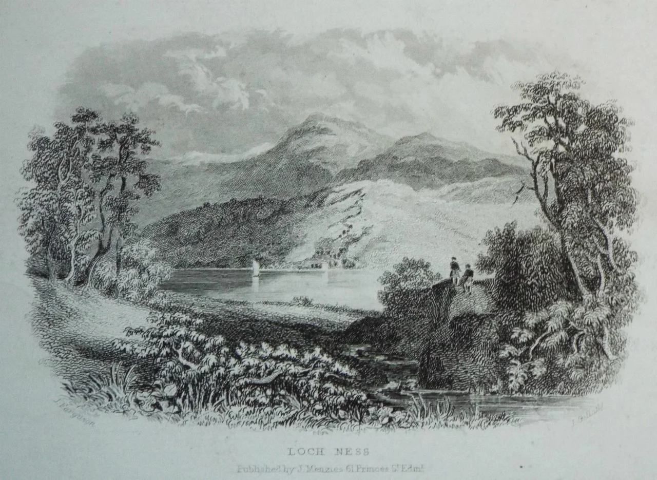
Loch Ness, by John Fleming, engraved by J Gellatly, published by J Menzies, Edinburgh. http://www.rareoldprints.com/z/21765

Loch Ness, by John Fleming, engraved by J Gellatly, published by J Menzies, Edinburgh. http://www.rareoldprints.com/z/21765

Glenmoriston Arms Hotel where Lucy would have enjoyed her breakfast and the Inn. It was originally a drover's inn, a stopover point for farmers taking their cattle to and from market. It dates to 1740, 6 years before the battle of Culloden. Part of this original structure is still in place today forming the Moriston Bar and Reception area with granite walls 3-4 feet thick.

From the Hotel's website, http://glenmoristonarms.co.uk/index.php

From the Hotel's website, http://glenmoristonarms.co.uk/index.php

It was the meeting place for Johnson & Boswell when they charted their journey to the Hebrides and also a favourite haunt for Charlie Chaplin in the 1930’s. http://glenmoristonarms.co.uk/index.php & http://glenmoristonarms.co.uk/Glen_Moriston_Brochure.pdf

Fall of Foyers: The river Foyers drops a spectacular 140 feet in to the gorge know as the Falls of Foyers, and then runs into Loch Ness, in 1787 inspiring Robert (Robbie) Burns to write a dramatic poem about the Falls. The falls and gorge soon became a popular tourist attraction for the “gentry”, arriving by paddle steamer from Inverness. http://enjoylochness.com/activities/falls-of-foyers

2009: The Fall of Foyers, by Zenit and licensed under the Creative Commons Attribution 2.0 Generic license. https://commons.wikimedia.org/wiki/File:Foyers_Falls.jpg

2009: The Fall of Foyers, by Zenit and licensed under the Creative Commons Attribution 2.0 Generic license. https://commons.wikimedia.org/wiki/File:Foyers_Falls.jpg

Below, from Lucy’s sketchbook dated September 4th 1819, her sketch entitled “Bridge over the Upper Fall of Foyers”

0904 bridge over upper fall of foyers.jpg

The earlier print below of the Upper Fall, circa 1774, shows a more perilous bridge hung straight over the falls

circa 1774: Upper Fall of Fyers. Engraving by P. Mazell after W. Tomkyns. https://antique-prints-maps.com/acatalog/ref1.php?imagefile=../largeimages/SEUpperFallsFyers19.jpg

circa 1774: Upper Fall of Fyers. Engraving by P. Mazell after W. Tomkyns. https://antique-prints-maps.com/acatalog/ref1.php?imagefile=../largeimages/SEUpperFallsFyers19.jpg

This waterfall influenced Robert Addams to write a paper in 1834 about the motion aftereffect. See https://www.illusionsindex.org/ir/waterfall-illusion

The Falls of Foyers by W. Beattie https://www.illusionsindex.org/ir/waterfall-illusion

Lucy’s sketch attempts to record the height of what she saw - “ Rough Sketch of the Lower Fall of Foyers Inverness-shire Sept 4th 1819” - below:

20190817_195222.jpg

Inn: Possibly the Drumnadrochit Hotel. It was the landlady here whose sighting of the Loch Ness Monster in 1833 spurred much of the modern interest in the phenomenon. Today the building holds one of two exhibitions in the village devoted to the loch and its monster. https://www.scottishaccommodationindex.com/drumnadrochitpics.htm

Drumnadrochit Castle. Lucy is referring to Urquhart Castle, near the village of Drumnadrochit.

2014 : Panorama of Urquhart Castle English by Cédric Bonhomme, the copyright holder of this work, and licensed under the Creative Commons Attribution-Share Alike 4.0 International license. https://commons.wikimedia.org/wiki/File:Urquhart_Castle_Pano…

2014 : Panorama of Urquhart Castle English by Cédric Bonhomme, the copyright holder of this work, and licensed under the Creative Commons Attribution-Share Alike 4.0 International license. https://commons.wikimedia.org/wiki/File:Urquhart_Castle_Panorama.jpg

The first documentary record of Urquhart Castle occurs in 1296, when it was captured by Edward I of England, marking the beginning of the Wars of Scottish Independence, which would go on intermittently until 1357. Subjected to clan feuds, the castle was subjected to ruinous damage, but by the close of the 16th century Urquhart had been rebuilt by the Grants, now a powerful force in the Highlands. Repairs and remodelling continued as late as 1623. In 1644 a mob of Covenanters (Presbyterian agitators) broke into the castle when Lady Mary Grant was staying, robbing her and turning her out for her adherence to Episcopalianism. An inventory taken in 1647 shows the castle virtually empty. When Oliver Cromwell invaded Scotland in 1650, he disregarded Urquhart in favour of building forts at either end of the Great Glen.

1779-1790c: Castle Urquhart, in the Shire of Inverness, in Scotland from the Modern Universal British Traveller http://www.rareoldprints.com/p/16639

1779-1790c: Castle Urquhart, in the Shire of Inverness, in Scotland from the Modern Universal British Traveller http://www.rareoldprints.com/p/16639

circa 1830: Castle Urquhart, Loch Ness. Granted by Charter to the family of Grant of Grant now Earls of Seafield. Engraving by W. Forrest after J. Fleming. https://antique-prints-maps.com/acatalog/ref1.php?imagefile=../largeimages/SECastleUrqhuartWF…

circa 1830: Castle Urquhart, Loch Ness. Granted by Charter to the family of Grant of Grant now Earls of Seafield. Engraving by W. Forrest after J. Fleming. https://antique-prints-maps.com/acatalog/ref1.php?imagefile=../largeimages/SECastleUrqhuartWF18.jpg

By the 1770s the castle was roofless, and was regarded as a romantic ruin by 19th-century painters and visitors to the Highlands. https://en.wikipedia.org/wiki/Urquhart_Castle

Inverness is the administrative centre for The Highland Council and is regarded as the capital of the Highlands.

2011: View over Inverness from the river Ness to the North , by Avarim , the copyright holder of this work, licensed under the Creative Commons Attribution-Share Alike 3.0 Unported license. https://commons.wikimedia.org/wiki/File:Inverness-pano.jpg

2011: View over Inverness from the river Ness to the North , by Avarim , the copyright holder of this work, licensed under the Creative Commons Attribution-Share Alike 3.0 Unported license. https://commons.wikimedia.org/wiki/File:Inverness-pano.jpg

It lies near two important battle sites: the 11th-century battle of Blàr nam Fèinne against Norway which took place on the Aird and the 18th century Battle of Culloden which took place on Culloden Moor. It is the northernmost city in the United Kingdom and lies within the Great Glen (Gleann Mòr) at its north-eastern extremity where the River Ness enters the Moray Firth. The Gaelic king Mac Bethad Mac Findláich (MacBeth) whose 11th-century killing of King Duncan was immortalised in Shakespeare's largely fictionalized play Macbeth, held a castle within the city where he ruled as Mormaer of Moray and Ross.

circa 1800: A view of Inverness in Scotland, with its bridge over the River Ness and Fort George on an Eminence near it, engraved for "The Modern Universal British Traveller." https://antique-prints-maps.com/acatalog/ref1.php?imagefile=../largeimage…

circa 1800: A view of Inverness in Scotland, with its bridge over the River Ness and Fort George on an Eminence near it, engraved for "The Modern Universal British Traveller." https://antique-prints-maps.com/acatalog/ref1.php?imagefile=../largeimages/SEInvernessEngTrav.JPG

In 1562, during the progress undertaken to suppress Huntly's insurrection, Mary, Queen of Scots, was denied admittance into Inverness Castle by the governor, who belonged to the earl's faction, and whom she afterwards caused to be hanged. https://en.wikipedia.org/wiki/Inverness

Bennett’s hotel is recorded as being visited by Count Itterberg, son of the ex-king of Sweden, on 7 June 1820. https://books.google.co.uk/books?id=rrQvAAAAYAAJ&pg=RA1-PA72&lpg=RA1-PA72&dq=%22bennett%27s%22+Hotel+Inverness&source=bl&ots=zb1W9UCRFF&sig=_3_za2BLJXF16ilIyfw0P5cyRl8&hl=en&sa=X&ved=2ahUKEwio9cWgvPzdAhUQyaQKHXCeCjoQ6AEwAXoECAsQAQ#v=onepage&q=%22bennett's%22%20Hotel%20Inverness&f=false


Can you help us?

Transcription problems: As untrained transcribers we sometimes experience problems interpreting some of Lucy’s writing. We have a problem deciphering a section today:

LUCY 124b-extract.jpg

We left Fort Augustus & breakfasted at Invermoriston ?***? this road to this ..
the word inserted by Lucy between Invermoriston and this has been a challenge. Help please!

Bennett’s hotel: Does the hotel still exist? It was the luxury hotel of its day - does it have another name? Was it rebuilt for a different purpose?

Old Regency Prints, Pictures an Coaching maps: Do you have access to any prints or pictures showing what town and country would have looked like when Lucy travelled through? Any illustrations of what she would have seen in 1819 will enliven our research.

New Pictures: Do you have any modern pictures of the streets, buildings, gardens and views that would enable us to see the changes that two centuries have wrought?

3rd September 1819, Letterfinlay, Loch Lochy, Inverlochy castle, Ben Nevis, new Caledonian Canal, Glengary Castle, Loch Oich

Friday 3rd September 1819

 
LUCY 123c.jpg
 
LUCY 124a.jpg
 

Sept 3rd The morning being sufficiently favourable for ascending Ben Nevis we started after breakfast for Letter Finly leaving on our left a short distance from Fort William the ruins of Inverlock Castle, we passed over 8 miles of a swept wild country catching fine views of the tremendous Ben Nevis on the north side of which

we saw a great quantity of snow which constantly remains Letter Finley Inn is situated on the side of Loch Lochy we took some refreshment’s there & proceeded to Fort Augustus passing in our way thither the new Caledonian Canal which is quite in an unfinished state & adopted for vessels navigating the North Sea to avoid the dangerous navigation of the Pentland Firth & north coast of Scotland & as a safe passage for shipping from the eastern coast of Britain. Glengary Castle is a picturesque ruin the ancient seat of the Macdonalds & situated on the banks of Loch Oich. Fort Augustus resembles in some degree Fort William situated a short distance from Loch Ness the Inn is very comfortable.


OBSERVATIONS & COMMENTS:

Letterfinlay is a small community midway along the length of Loch Lochy. http://www.maplandia.com/united-kingdom/scotland/scotland/highland/letterfinlay/

Inverlochy Castle originally dated back to the 13th century.

1857: Inverlochy Castle, by Horatio McCulloch (1805–1867), in the public domain https://commons.wikimedia.org/wiki/File:Inverlochycastle.jpg

1857: Inverlochy Castle, by Horatio McCulloch (1805–1867), in the public domain https://commons.wikimedia.org/wiki/File:Inverlochycastle.jpg

1888: Inverlochy Castle, Fort William, West Highlands. chromolithographic print. https://www.ebay.co.uk/itm/153454907353

1888: Inverlochy Castle, Fort William, West Highlands. chromolithographic print. https://www.ebay.co.uk/itm/153454907353

It last played a part in Scottish and English history during the Civil Wars of the 1640’s. In 1645 the royalist Earl of Montrose routed the roundhead forces of the Campbell Chief Duke of Argyll at the second Battle of Inverlochy. In 1654 the Castle was abandoned in favour of a large timber fort built nearby by Cromwell which in 1690 was then replaced by a stone fort named “Fort William” after King William III. https://www.inverlochycastle.co.uk/

2006: Inverlochy Castle near Fort William, by Jmb at English Wikipedia, licensed under the Creative Commons Attribution 2.5 Generic license. https://commons.wikimedia.org/wiki/File:Inverlochy_Castle_PICT6929.jpg

2006: Inverlochy Castle near Fort William, by Jmb at English Wikipedia, licensed under the Creative Commons Attribution 2.5 Generic license. https://commons.wikimedia.org/wiki/File:Inverlochy_Castle_PICT6929.jpg

Ben Nevis is the highest mountain in the British Isles. The first recorded ascent was made on 17 August 1771 by James Robertson, an Edinburgh botanist, who was in the region to collect botanical specimens. John Keats climbed the mountain in 1818, comparing the ascent to "mounting ten St. Pauls without the convenience of a staircase".

1836: Ben Nevis and Entrance to the Caledonian Canal, an engraving by S. Fisher after T. Allom. https://antique-prints-maps.com/acatalog/ref1.php?imagefile=../largeimages/SEBenNevisCalCanal12.jpg

1836: Ben Nevis and Entrance to the Caledonian Canal, an engraving by S. Fisher after T. Allom. https://antique-prints-maps.com/acatalog/ref1.php?imagefile=../largeimages/SEBenNevisCalCanal12.jpg

In the year of Lucy’s visit (1819), William MacGillivray, who was later to become a distinguished naturalist, reached the summit only to find "fragments of earthen and glass ware, chicken bones, corks, and bits of paper". https://en.wikipedia.org/wiki/Ben_Nevis


1889: Ben Nevis From Corpach from, “Souvenir of Scotland: its Cities, Lakes, and Mountains.” Published by T. Nelson and Sons, London, Edinburgh and New York. https://www.mapsandantiqueprints.com/wp-content/uploads/2010/11/p-1494-446-509.jpg

1889: Ben Nevis From Corpach from, “Souvenir of Scotland: its Cities, Lakes, and Mountains.” Published by T. Nelson and Sons, London, Edinburgh and New York. https://www.mapsandantiqueprints.com/wp-content/uploads/2010/11/p-1494-446-509.jpg

2005: Ben Nevis, 1,344 metres, Scotland. Photograph taken from Banavie about 8 km north west. This work has been released into the public domain by its author, Thincat. https://commons.wikimedia.org/wiki/File:BenNevis2005.jpg

2005: Ben Nevis, 1,344 metres, Scotland. Photograph taken from Banavie about 8 km north west. This work has been released into the public domain by its author, Thincat. https://commons.wikimedia.org/wiki/File:BenNevis2005.jpg

Letter Finley Inn (now “Kings House”, a holiday rental property) was built in 1735. History books say General Wade once stayed here and Prince Charlie rested at this former Inn after landing in Scotland. The property is decorated in a mix of Jacobean and contemporary styles. https://www.tripadvisor.co.uk/VacationRentalReview-g1096487-d12481119-Historic_Kings_House-Letterfinlay_Scottish_Highlands_Scotland.html

Loch Lochy is the third-deepest loch of Scotland. The River Lochy flows from its southwestern end while the Caledonian Canal links its north-eastern extent to Loch Oich. Folklore tales mention 'a supernatural being' called the River Horse which was said to emerge from the lake and assume a horse's shape before feeding on the loch's banks. The River Horse was also known as the Lord of The Lake and the Water King and would overturn boats and 'entice mares from their pastures'.

2005: Loch Lochy, by Andrew McLean. This image was taken from the Geograph project collection. The copyright on this image is owned by Andrew McLean and is licensed for reuse under the Creative Commons Attribution-ShareAlike 2.0 license. https://com…

2005: Loch Lochy, by Andrew McLean. This image was taken from the Geograph project collection. The copyright on this image is owned by Andrew McLean and is licensed for reuse under the Creative Commons Attribution-ShareAlike 2.0 license. https://commons.wikimedia.org/wiki/File:Loch_Lochy.jpg

Another tradition was that of the River Bull, 'a gentle, harmless creature', who would 'emerge from the lake into the pasture of cows'. https://en.wikipedia.org/wiki/Loch_Lochy

Fort Augustus was originally a Gaelic settlement that was renamed Fort Augustus in the aftermath of the Jacobite rising in 1715. General Wade built a fort (taking from 1729 until 1742) which was named after the Duke of Cumberland. He had planned to build a town around the new barracks and call it Wadesburgh. The settlement grew, and eventually took the name of this fort.

1788: The old fort at Fort Augusts, Scottish Highlands from "Remarkable ruins, and romantic prospects, of North Britain : with ancient monuments, and singular subjects of natural history". By Charles Cordiner https://commons.wikimedia.org/wiki/File:…

1788: The old fort at Fort Augusts, Scottish Highlands from "Remarkable ruins, and romantic prospects, of North Britain : with ancient monuments, and singular subjects of natural history". By Charles Cordiner https://commons.wikimedia.org/wiki/File:Fort_Augusts_(Old_Fort)_2.png

1882: Fort Augustus, Scotland, from Ordnance gazetteer of Scotland : a survey of Scottish topography, statistical, biographical, and historical by Francis Hindes Groome, 1851-1902, published T.C. Jack, Edinburgh https://commons.wikimedia.org/wiki/Fi…

1882: Fort Augustus, Scotland, from Ordnance gazetteer of Scotland : a survey of Scottish topography, statistical, biographical, and historical by Francis Hindes Groome, 1851-1902, published T.C. Jack, Edinburgh https://commons.wikimedia.org/wiki/File:Fort_Augustus_(old_fort).jpg

The fort was captured by the Jacobites in March 1746, just prior to the Battle of Culloden. https://en.wikipedia.org/wiki/Fort_Augustus

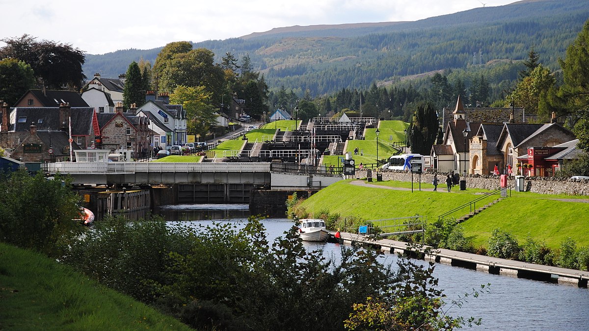
Caledonian Canal: In 1620, a Highland prophet called the Brahan Seer predicted that full-rigged ships would one day be sailing round the back of Tomnahurick, near Inverness, at a time when the only navigable route near the location was the River Ness, on the other side of Tomnahurick. The Commissioners of Forfeited Estates had originally been set up to handle the seizure and sale of land previously owned by those who had been convicted of treason following the Jacobite rising of 1715. By 1773, they had turned their attention to helping the fishing industry, and commissioned the inventor and mechanical engineer James Watt to make a survey of the route. His report in 1774, emphasised the benefits to the fishing industry, of a shorter and safer route from the east to the west coast of Scotland, and the potential for supplying the population with cheaper corn. In 1785 John Knox expounded the benefits of it relieving distress in the Highlands, and preventing ships having to navigate the dangerous Pentland Firth between the Orkney Islands and Caithness. William Fraser, when proposing his own scheme for a canal in 1793, announced that "nature had finished more than half of it already". At the time, much of the Highlands were depressed as a result of the Highland Clearances, which had deprived many of their homes and jobs. Laws had been introduced which sought to eradicate the local culture, including bans on wearing tartan, playing the bagpipes, and speaking Scottish Gaelic. Many emigrated to Canada or elsewhere, or moved to the Scottish Lowlands. The engineer Thomas Telford was asked to investigate the problem of emigration in 1801, and in 1802 published his report, which suggested that the problem was caused by landowners who had previously kept cattle creating vast sheep-farms. Realising that direct government action to tackle the issue would be seen as interference, he therefore suggested that a programme of public works, involving roads, bridges and canals, would be a way to provide jobs for people who had been displaced by the sheep farming, and to stimulate industry, fishery and agriculture. Telford consulted widely with shipowners, who favoured a canal . An additional benefit would be the protection that the canal offered to shipping from attacks by French privateers.

1903: An antique engraving which was published in "The Illustrated London News" on March 21st, 1903. A Bird's Eye view of the positions of Forth and Clyde Canal, Bowling Harbour, Caledonian Railway, North British Railway, River Clyde, Bowling Shipya…

1903: An antique engraving which was published in "The Illustrated London News" on March 21st, 1903. A Bird's Eye view of the positions of Forth and Clyde Canal, Bowling Harbour, Caledonian Railway, North British Railway, River Clyde, Bowling Shipyard, Dunglass Castle, Lord Blantyre's Mansion, Auchintorlie House, Old Kilpatrick, Glasgow and Paisley.

In 1803, an Act of Parliament was passed to authorise the project and enable the work to start. A second Act of Parliament granted £50,000 per year of government money, payable in two instalments, to fund the ongoing work and provision was made for private investors to buy shares in the scheme, for any amount over £50. The canal was expected to take seven years to complete, and to cost £474,000, to be funded by the Government, but both estimates were inadequate. There were also problems with the labour force, with high levels of absence, particularly during and after the potato harvest and the peat cutting season. This led to Telford bringing in Irish navvies to manage the shortfall, which led to further criticism, since one of the main aims of the project was to reduce unemployment in the Highlands. The canal finally opened in 1822, having taken an extra 12 years to complete, and cost £910,000. Over 3,000 local people had been employed in its construction, but the draught had been reduced from 20 feet to 15 feet, in an effort to save costs.

2009: The Dochgarroch Lock along the Caledonian Canal with its lower gates open. The upper gates leading to Loch Dochfour are closed, by Gregory J Kingsley, the copyright holder of this work, licensed under the Creative Commons Attribution-Share Ali…

2009: The Dochgarroch Lock along the Caledonian Canal with its lower gates open. The upper gates leading to Loch Dochfour are closed, by Gregory J Kingsley, the copyright holder of this work, licensed under the Creative Commons Attribution-Share Alike 3.0 Unported license https://commons.wikimedia.org/wiki/File:Dochgarroch_Lock_-_kingsley_-_30-JUN-09.JPG

2002: Caledonian Canal in Fort Augustus, Scotland by Wojsyl, the copyright holder of this work and licensed under the Creative Commons Attribution-Share Alike 3.0 Unported license. https://commons.wikimedia.org/wiki/File:Scotland_FortAugustus_Caledo…

2002: Caledonian Canal in Fort Augustus, Scotland by Wojsyl, the copyright holder of this work and licensed under the Creative Commons Attribution-Share Alike 3.0 Unported license. https://commons.wikimedia.org/wiki/File:Scotland_FortAugustus_CaledonianCanal.jpg

In the meantime, shipbuilding had advanced, with the introduction of steam-powered iron-hulled ships, many of which were now too big to use the canal. The Royal Navy did not need to use the canal either, as Napoleon had been defeated at Waterloo in 1815, and the perceived threat to shipping when the canal was started was now gone. https://en.wikipedia.org/wiki/Caledonian_Canal - LUCY NOTES ITS UNFINISHED STATE

2011: Caledonian Canal, Fort Augustus, Scotland. By Leandro Neumann Ciuffo, Eclusas do canal Caledonia. This file is licensed under the Creative Commons Attribution 2.0 Generic license. https://commons.wikimedia.org/wiki/File:Eclusas_do_canal_Caledo…

2011: Caledonian Canal, Fort Augustus, Scotland. By Leandro Neumann Ciuffo, Eclusas do canal Caledonia. This file is licensed under the Creative Commons Attribution 2.0 Generic license. https://commons.wikimedia.org/wiki/File:Eclusas_do_canal_Caledonia_(6194580521).jpg

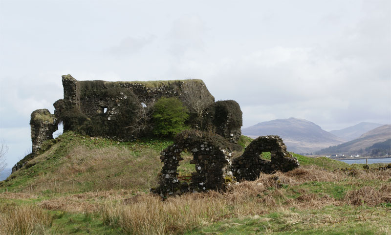
Glengary Castle: During the Jacobite risings of 1745 to 1746, Prince Charles Edward Stuart – "Bonnie Prince Charlie" – visited the Castle shortly after the raising of the Royal Standard at Glenfinnan and is said to have rested there after his defeat at the Battle of Culloden, in 1746. In the aftermath of Culloden it was sacked and partially blown up by troops under Duke of Cumberland as part of his systematic suppression of the Highlands.

1836: Loch Oich, with Invergarry Castle. (Invernesshire), engraving by J. Redaway after T. Allom. https://antique-prints-maps.com/acatalog/ref1.php?imagefile=../largeimages/SELochOich15.jpg

1836: Loch Oich, with Invergarry Castle. (Invernesshire), engraving by J. Redaway after T. Allom. https://antique-prints-maps.com/acatalog/ref1.php?imagefile=../largeimages/SELochOich15.jpg

1889: Invergarry Castle Loch Oich Scotland antique print from “Souvenir of Scotland: its Cities, Lakes, and Mountains.” Published by T. Nelson and Sons, London, Edinburgh and New York. https://www.mapsandantiqueprints.com/wp-content/uploads/2010/09/…

1889: Invergarry Castle Loch Oich Scotland antique print from “Souvenir of Scotland: its Cities, Lakes, and Mountains.” Published by T. Nelson and Sons, London, Edinburgh and New York. https://www.mapsandantiqueprints.com/wp-content/uploads/2010/09/p-957-265-319.jpg

2009: Invergarry Old Castle Invergarry Castle by Astrid Horn. This image was taken from the Geograph project collection. The copyright on this image is owned by Astrid Horn and is licensed for reuse under the Creative Commons Attribution-ShareAlike …

2009: Invergarry Old Castle Invergarry Castle by Astrid Horn. This image was taken from the Geograph project collection. The copyright on this image is owned by Astrid Horn and is licensed for reuse under the Creative Commons Attribution-ShareAlike 2.0 license. https://commons.wikimedia.org/wiki/File:Invergarry_Old_Castle_-_geograph.org.uk_-_1515750.jpg

However the stout walls refused to yield and have survived the centuries to serve as a reminder to their history. https://en.wikipedia.org/wiki/Invergarry_Castle

Loch Oich forms part of the Caledonian Canal, of which it is the highest point. Thomas Telford artificially raised the level of the loch by many feet to provide a navigable channel for the Caledonian Canal. https://en.wikipedia.org/wiki/Loch_Oich

2005: Loch Oich, the highest loch in the Great Glen geological fault, by Claire Pegrum. This image was taken from the Geograph project collection. The copyright on this image is owned by Claire Pegrum and is licensed for reuse under the Creative Com…

2005: Loch Oich, the highest loch in the Great Glen geological fault, by Claire Pegrum. This image was taken from the Geograph project collection. The copyright on this image is owned by Claire Pegrum and is licensed for reuse under the Creative Commons Attribution-ShareAlike 2.0 license. https://commons.wikimedia.org/wiki/File:Loch_Oich.jpg

The Kings Inn, built in 1705 during the construction of General Wade's roads, is reputedly the oldest surviving building in Fort Augustus. The original inn, now separated into three dwellings, has had several famous guests in the past including: Samuel Taylor Coleridge Boswell and Dr Johnson. https://www.britainexpress.com/scotland/Highlands/bb/BE48421.htm


Can you help us?

Old Regency Prints, Pictures an Coaching maps: Do you have access to any prints or pictures showing what town and country would have looked like when Lucy travelled through? Any illustrations of what she would have seen in 1819 will enliven our research.

New Pictures: Do you have any modern pictures of the streets, buildings, gardens and views that would enable us to see the changes that two centuries have wrought?

2nd September 1819, Fort William, Loch Eil

Thursday 2nd September 1819

 
LUCY 123b.jpg

Thursday Sept 2nd About one o’clock we crossed the ferry & proceeded to Fort William to dinner 14 miles, the road which is excessively good lies over the banks of Loch Eil encompassed by fine mountains; Fort William is a small town with a pretty fort Major Cameron a very agreeable gentleman whom we met here showed us all over the it the Inn is very comfortable.


OBSERVATIONS & COMMENTS:

Fort William: The earliest recorded settlement on the site is a Cromwellian wooden fort built in 1654 as a base for English troops to "pacify" Clan Cameron after the Wars of the Three Kingdoms. The post-Glorious Revolution fort was named Fort William after William of Orange who ordered that it be built to control the Highland clans.

1889: Loch Eil and Fort William from, “Souvenir of Scotland: its Cities, Lakes, and Mountains.” Published by T. Nelson and Sons, London, Edinburgh and New York. https://www.mapsandantiqueprints.com/wp-content/uploads/2010/09/p-981-273-327-1000x675.j…

1889: Loch Eil and Fort William from, “Souvenir of Scotland: its Cities, Lakes, and Mountains.” Published by T. Nelson and Sons, London, Edinburgh and New York. https://www.mapsandantiqueprints.com/wp-content/uploads/2010/09/p-981-273-327-1000x675.jpg

2007: Fort William viewed from Corpach by Andrew R Palmer and licensed under the Creative Commons Attribution-ShareAlike 3.0 License. https://en.wikipedia.org/wiki/File:FortWilliam.jpg

2007: Fort William viewed from Corpach by Andrew R Palmer and licensed under the Creative Commons Attribution-ShareAlike 3.0 License. https://en.wikipedia.org/wiki/File:FortWilliam.jpg

The settlement that grew around it was called Maryburgh, after his wife Mary II of England. This settlement was later renamed Gordonsburgh, and then Duncansburgh before being renamed Fort William, this time after Prince William, Duke of Cumberland; known to some Scots as "Butcher Cumberland". https://en.wikipedia.org/wiki/Fort_William,_Highland

2011: Fort William Parade and the Duncansburgh MacIntosh Parish Church by Elizabeth B. Thomsen, the copyright holder. Licensed under the Creative Commons Attribution-Share Alike 4.0 International license. https://commons.wikimedia.org/wiki/File:Fort…

2011: Fort William Parade and the Duncansburgh MacIntosh Parish Church by Elizabeth B. Thomsen, the copyright holder. Licensed under the Creative Commons Attribution-Share Alike 4.0 International license. https://commons.wikimedia.org/wiki/File:FortWilliamParade.jpg

2005: Fort William High Street Lochaber High School band march down the High Street by Sarah Charlesworth, the copyright holder. This image was taken from the Geograph project collection and is licensed for reuse under the Creative Commons Attributi…

2005: Fort William High Street Lochaber High School band march down the High Street by Sarah Charlesworth, the copyright holder. This image was taken from the Geograph project collection and is licensed for reuse under the Creative Commons Attribution-Share Alike 2.0 Generic license. https://commons.wikimedia.org/wiki/File:Fort_William_High_Street_-_geograph.org.uk_-_987377.jpg

NOTE: Lucy and family were shown around the garrison by Major Cameron (the Cameron Clan was local to the area)

Below, artistic impression of Bonnie Prince Charlie’s march with his highland army along Loch Eil in 1746

1836: Passage of the Highland Army along the side of Loch Eil, 1746, by Thomas Allom (1804-72), engraved H. Griffiths, from "Scotland Illustrated" by William Beattie (1793-1875), published George Virtue https://antiquemaps.co.nz/products/passage-of-…

1836: Passage of the Highland Army along the side of Loch Eil, 1746, by Thomas Allom (1804-72), engraved H. Griffiths, from "Scotland Illustrated" by William Beattie (1793-1875), published George Virtue https://antiquemaps.co.nz/products/passage-of-the-highland-army-loch-eil-1746

Loch Eil is a sea loch that opens into Loch Linnhe near the town of Fort William. The name of the Chief of Clan Cameron is spelt LOCHIEL, while the name of the loch is spelt LOCH EIL. Lochiel was a historic place east of Fassfern on the north shore of Loch Eil and home to Jacobite chieftain Donald Cameron, of Lochiel. https://en.wikipedia.org/wiki/Loch_Eil

2016: Eilean nan Craobh, once home to Lochiel, chief of Clan Cameron by Ronald Cameron, the copyright holder of this work, published under the Creative Commons Attribution-Share Alike 4.0 International license. https://commons.wikimedia.org/wiki/Fil…

2016: Eilean nan Craobh, once home to Lochiel, chief of Clan Cameron by Ronald Cameron, the copyright holder of this work, published under the Creative Commons Attribution-Share Alike 4.0 International license. https://commons.wikimedia.org/wiki/File:Eilean_nan_Craobh.jpg

2016: Loch Eil and head of Loch Linnhe from the slopes of Carn Mòr Dearg by Ronald Cameron, the copyright holder of this work, published under the Creative Commons Attribution-Share Alike 4.0 international license. https://commons.wikimedia.org/wiki…

2016: Loch Eil and head of Loch Linnhe from the slopes of Carn Mòr Dearg by Ronald Cameron, the copyright holder of this work, published under the Creative Commons Attribution-Share Alike 4.0 international license. https://commons.wikimedia.org/wiki/File:Loch_Eil_from_CMD.jpg


Can you help us?

Old Regency Prints, Pictures an Coaching maps: Do you have access to any prints or pictures showing what town and country would have looked like when Lucy travelled through? Any illustrations of what she would have seen in 1819 will enliven our research.

New Pictures: Do you have any modern pictures of the streets, buildings, gardens and views that would enable us to see the changes that two centuries have wrought?

1st September 1819, Glencoe

Wednesday 1st September 1819

 
LUCY 122b.jpg
 
LUCY 123a.jpg

Wednesday Sept 1st We were very much alarmed last night at the gentleman not returning till very late on account of the tremendous weather which obliged them to land several miles away & walk to the Inn in the dark the waterfalls were nothing very striking at two o’clock this morning we made an excursion to Glenco whose stupendous & craggy mountains surpass anything I have seen the incessant rain of yesterday which has still continued rendered the generally ?***? cataracts quite torrents & the angry clouds which hovered about the mountains gave

the whole a grand & terrific effect we rode a few miles through the glen & returned the same way to the Inn


OBSERVATIONS & COMMENTS:

Glencoe: Glencoe’s scenic beauty has led to its inclusion in the Ben Nevis and Glen Coe National Scenic Area.

1812: To the Most Noble George Marquis of Tweedale &c &c this View of the Valley of Glencoe is respectfully Inscribed by His Lordships most obedient Servant, Robert Andrew Riddell. Engraver: R A Robertson, Publisher: Boydell & Co http://…

1812: To the Most Noble George Marquis of Tweedale &c &c this View of the Valley of Glencoe is respectfully Inscribed by His Lordships most obedient Servant, Robert Andrew Riddell. Engraver: R A Robertson, Publisher: Boydell & Co http://www.rareoldprints.com/p/3429

A review of the national scenic areas by Scottish Natural Heritage in 2010 referred to the "soaring, dramatic splendour of Glen Coe", and "the suddenness of the transition between high mountain pass and the lightly wooded strath" in the lower glen.

1889: The Pass of Glencoe, Scottish Highlands, from “Souvenir of Scotland: its Cities, Lakes, and Mountains.” Published by T. Nelson and Sons, London, Edinburgh and New York. https://www.mapsandantiqueprints.com/wp-content/uploads/2010/09/p-1119-319…

1889: The Pass of Glencoe, Scottish Highlands, from “Souvenir of Scotland: its Cities, Lakes, and Mountains.” Published by T. Nelson and Sons, London, Edinburgh and New York. https://www.mapsandantiqueprints.com/wp-content/uploads/2010/09/p-1119-319-373.jpg

2013: View from the old road, now the West Highland Way, at the entrance to Glen Coe, looking west, with Buachaille Etive Mòr and Buachaille Etive Beag on the left, and Aonach Eagach to the right. By Dave Souza, the copyright holder of this work, an…

2013: View from the old road, now the West Highland Way, at the entrance to Glen Coe, looking west, with Buachaille Etive Mòr and Buachaille Etive Beag on the left, and Aonach Eagach to the right. By Dave Souza, the copyright holder of this work, and licensed under the Creative Commons Attribution-Share Alike 3.0 Unported license. https://commons.wikimedia.org/wiki/File:130707_Glen_Coe_from_east_C.jpg

2006: Glencoe, Scotland, by Superbass, the copyright holder of this work, and licensed under the Creative Commons Attribution-Share Alike 3.0 Unported license. https://commons.wikimedia.org/wiki/File:Glencoepanorama.jpg

2006: Glencoe, Scotland, by Superbass, the copyright holder of this work, and licensed under the Creative Commons Attribution-Share Alike 3.0 Unported license. https://commons.wikimedia.org/wiki/File:Glencoepanorama.jpg

The main settlement is the village of Glencoe located at the foot of the glen, which is regarded as the home of Scottish mountaineering. On the 13 February 1692, in the aftermath of the Jacobite uprising of 1689, an incident known as the Massacre of Glencoe took place in the glen. Thirty-eight men from Clan MacDonald of Glencoe were killed by government forces who were billeted with them on the grounds that they had not been prompt in pledging allegiance to the new monarchs, William II and Mary II. Glencoe is supposed to have been the birthplace of Ossian. https://en.wikipedia.org/wiki/Glen_Coe

2012: The 'cave' can be seen upper right on the slope of Aonach Dubh, one of The Three Sisters in the 'Glen of Weeping'. By Kim Traynor, the copyright holder of this work, licensed under the Creative Commons Attribution-Share Alike 3.0 Unported lice…

2012: The 'cave' can be seen upper right on the slope of Aonach Dubh, one of The Three Sisters in the 'Glen of Weeping'. By Kim Traynor, the copyright holder of this work, licensed under the Creative Commons Attribution-Share Alike 3.0 Unported license. https://commons.wikimedia.org/wiki/File:Ossian%27s_Cave,_Glencoe.JPG

Ossian was reputed to be the narrator and purported author of a cycle of epic poems published by the Scottish poet James Macpherson from 1760. Macpherson claimed to have collected word-of-mouth material in Scottish Gaelic, said to be from ancient sources, and that the work was his translation of that material. Ossian is based on Oisín, son of Finn or Fionn mac Cumhaill, anglicised to Finn McCool, a legendary bard who is a character in Irish mythology. Contemporary critics were divided in their view of the work's authenticity, but the consensus since is that Macpherson framed the poems himself, based on old folk tales he had collected. https://en.wikipedia.org/wiki/Ossian


Can you help us?

Transcription problems: As untrained transcribers we sometimes experience problems interpreting some of Lucy’s writing. We have a problem deciphering a section today:

LUCY 122b-extract.jpg

has still continued rendered the generally ?***? cataracts quite torrents &
We need expert help on interpreting this word.

Old Regency Prints, Pictures an Coaching maps: Do you have access to any prints or pictures showing what town and country would have looked like when Lucy travelled through? Any illustrations of what she would have seen in 1819 will enliven our research.

New Pictures: Do you have any modern pictures of the streets, buildings, gardens and views that would enable us to see the changes that two centuries have wrought?

31st August 1819, Ballachulish, waterfall

Tuesday 31st August 1819

 
LUCY 121c.jpg
 
LUCY 122a.jpg
 

Tuesday 31st The morning was beautifully serene & after breakfast we embarked for Ballachulish a breeze fortunately

sprang up in our favour which kindly wafted us to our place of destination in two or three hours the Ferry house which is the Inn is tolerably comfortable; the gentlemen sailed on some miles further to see a waterfall.


OBSERVATIONS & COMMENTS:


Ballachulish Ferry House. Its history timeline is carefully detailed by the Ballachulish Community Association:

1800: Dr Thomas Garnett undertook a tour of the Highlands in 1800, and wrote an ‘Observation’ or diary of his journey. He had the following to say of his stay at the Ballachulish Ferry House: “We found the accommodation both for ourselves and our horse at the ferry-house of Ballichellish very uncomfortable, but being fatigued by the labour and heat of the preceding day, we slept tolerably, and early the next morning set off for Glencoe.”

1801: After over a Decade at Christ Church College in Oxford, John Stoddart undertook a tour of Scotland in 1801. He was later to be editor of The Times, but his main career was as a lawyer and later Judge. He wrote about his tour of Scotland in ‘Remarks on the Local Scenery and Manners of Scotland’ and has this to say about his stay in Ballachulish: “A mile or two more brought us to Ballachulish, where we experienced the warmest welcome from Captain and Mrs Stewart… The landscape is continually varied, by cottages, by the great slate-work of Ballachulish, by a lime-kiln, and various other objects on the wayside; by the islands in the lake; and by the woods and residences at the base of the mountains.”

1801: Mrs Mary Aust wrote a ‘Companion and Useful Guide to Beauties of Scotland’ in which she says that “The Inn at Bailechoalish is small, but it was neatly kept by a new landlady. In general it is ill kept.” This seems to support Garnett’s opinion of the previous year, but suggests that the new landlady may be trying to improve matters. There are further words of warning, however, as she also claims that it once took 11 hours to do the ‘about 26 miles’ from Oban to Ballachulish, thanks to the lack of people available to help load her carriage at Connel and Shian ferries. Sadly there is no mention of her experience with the Ballachulish Ferry.

1817-21: The Commission for Highland Roads and Bridges, under the supervision of Thomas Telford takes over responsibility for the Military Roads and also the Glencoe Drove Road. Subsequent to this, improvements are carried out on the route along Loch Leven and over the Ballachulish Ferry.

In 1819, on their tour of Telford’s Works, Thomas Telford, his colleagues Joseph Mitchell and John Rickman and their friend the poet Robert Southey stayed at Ballachulish Ferry for the night. Because neither Inn had enough room for all of their party, they split into two groups, half staying on each side of the ferry. http://balla-hall.co.uk/ballachulish-heritage/ballachulish-timeline/1800-1869/

This photograph was taken from the hotel’s website, http://www.lochlevenhotel.co.uk/

This photograph was taken from the hotel’s website, http://www.lochlevenhotel.co.uk/

The Loch Leven Hotel claims to be a historic ferry Inn dating back to the time of Bonnie Prince Charlie. http://www.lochlevenhotel.co.uk/ However, The Ballachulish Community Association notes that: “As with the Ballachulish Hotel above, there has almost certainly been an Inn or Hotel on the current site since the early 18th Century when the ferry started operating, if not long before. However, the current building appears to largely date from c1860.”


Can you help us?

Ballachulish Ferry House: Does it still exist?

Loch Levin Hotel: Could this be where the Coplands stayed?

Old Regency Prints, Pictures an Coaching maps: Do you have access to any prints or pictures showing what town and country would have looked like when Lucy travelled through? Any illustrations of what she would have seen in 1819 will enliven our research.

New Pictures: Do you have any modern pictures of the streets, buildings, gardens and views that would enable us to see the changes that two centuries have wrought?

30th August 1819, Ballachulish, Appin

Monday 30th August 1819

 
LUCY 121b.jpg
 

Monday 30th August At nine o’clock we set sail for Ballachulish the day was very wet & the wind quite against us both which disagreeable circumstances greatly increasing towards the evening obliged us to land & sleep at a place called Appin where there is a very small Inn 16 miles from Ballachulish we arrived here at a very late hour.


OBSERVATIONS & COMMENTS:

Ballachulish (from Gaelic) means "the Village by the Narrows" at the mouth of Loch Leven.

2006: Ballachulish, Lochaber, Highland, Scotland seen from the lower slopes of Beinn Bhàn, by Lessthankris41. This work has been released into the public domain by its author, Lessthankris41 at English Wikipedia. https://commons.wikimedia.org/wiki/F…

2006: Ballachulish, Lochaber, Highland, Scotland seen from the lower slopes of Beinn Bhàn, by Lessthankris41. This work has been released into the public domain by its author, Lessthankris41 at English Wikipedia. https://commons.wikimedia.org/wiki/File:Balachulish_by_Lessthankris.jpg

As there was no road to the head of Loch Leven, the Ballachulish Ferry, established in 1733, was essential.

circa 1870: Ballachulish Ferry Hotels, photograph by James Valentine, in the public domain. https://en.wikipedia.org/wiki/Ballachulish#/media/File:Ballachulish_Ferry_Hotels,_James_Valentine_photograph_c._1870.png

circa 1870: Ballachulish Ferry Hotels, photograph by James Valentine, in the public domain. https://en.wikipedia.org/wiki/Ballachulish#/media/File:Ballachulish_Ferry_Hotels,_James_Valentine_photograph_c._1870.png

Ballachulish House was reputed to be haunted, and the drive leading to it was ridden by a headless horseman. Overlooking the narrows is the monument to James of the Glen, "hanged on this spot for a crime of which he was not guilty". Robert Louis Stevenson based his novel Kidnapped around the story of the Appin Murder. https://en.wikipedia.org/wiki/Ballachulish

Appin village lies at the seaward end of the Strath of Appin.

2005: Appin Village , by Mike and Kirsty Grundy. This image was taken from the Geograph project collection. The copyright on this image is owned by Mike and Kirsty Grundy and is licensed for reuse under the Creative Commons Attribution-ShareAlike 2.…

2005: Appin Village , by Mike and Kirsty Grundy. This image was taken from the Geograph project collection. The copyright on this image is owned by Mike and Kirsty Grundy and is licensed for reuse under the Creative Commons Attribution-ShareAlike 2.0 license. https://commons.wikimedia.org/wiki/File:Appin_Village.jpg

https://en.wikipedia.org/wiki/Appin

Inn: The original 18th century ferry inn at Port Appin is now the Airds Hotel. Their website states Once through into the main hallway of the original 18th century ferry inn, the atmosphere of our family run, luxury 4-star hotel is one of a Scottish country house, where personal service, luxury and a gourmet dining experience are the very essence of all that is great about a visit to our exclusive retreat. https://www.airds-hotel.com/information/contact-us/ Lucy describes their accommodation as a very small Inn and some doubt must remain as to whether this is where they stayed.


Can you help us?

Old Regency Prints, Pictures an Coaching maps: Do you have access to any prints or pictures showing what town and country would have looked like when Lucy travelled through? Any illustrations of what she would have seen in 1819 will enliven our research.

New Pictures: Do you have any modern pictures of the streets, buildings, gardens and views that would enable us to see the changes that two centuries have wrought?

29th August 1819, Staffa, Fingal’s Cave, Aros

Sunday 29th August 1819

 
LUCY 119c.jpg
 
LUCY 120.jpg
 
LUCY 121a.jpg
 

Sunday 29th Augt We determined not

to remain longer in this wretched place than we could help & took a boat at seven o’clock & sailed to Staffa in two hours the wind being quite favourable; on arriving we were much struck with the great beauty of this natural curiosity the islands near Ulva I must describe are all of a basaltic nature but the pillars of Staffa are much finer: this is this island is about 3 quarters of a mile in length and covered at the top with grass; when we landed we walked on the top of the columns to Fingal’s Cave I was much struck with it the sea goes in a considerable distance through a narrow chasm covered with large basaltic pillars I think it is out of my power to describe in any way this great

curiosity & after passing some time here we ascended on the tops of the columns which from their irregularity form a kind of staircase to the summit of the island we took some refreshment; we then did intend to go to Iona but the wind being directly against us we returned to Aross where we slept.


OBSERVATIONS & COMMENTS:

Staffa derives its name from the Old Norse for stave or pillar island. The Vikings gave it this name as its columnar basalt reminded them of their houses, which were built from vertically placed tree-logs.

2018: Panorama of the Isle of Staffa, Inner Hebrides, Scotland by Pderuvo, the copyright holder, and published it under the Creative Commons Attribution-Share Alike 4.0 International license. https://commons.wikimedia.org/wiki/File:Isle_of_Staffa_Pa…

2018: Panorama of the Isle of Staffa, Inner Hebrides, Scotland by Pderuvo, the copyright holder, and published it under the Creative Commons Attribution-Share Alike 4.0 International license. https://commons.wikimedia.org/wiki/File:Isle_of_Staffa_Panorama.jpg

circa 1774: Bending Pillars in Staffa. Engraving by P. Mazell after Millar. https://antique-prints-maps.com/acatalog/ref1.php?imagefile=../largeimages/SEBendingPillars19.jpg

circa 1774: Bending Pillars in Staffa. Engraving by P. Mazell after Millar. https://antique-prints-maps.com/acatalog/ref1.php?imagefile=../largeimages/SEBendingPillars19.jpg

2004: Basalt on the little island beside the Isle of Staffa, Scotland by Hartmut Josi Bennöhr. This file is licensed under the Creative Commons Attribution-Share Alike 3.0 Unported license. https://commons.wikimedia.org/wiki/File:Staffa_beside_14624…

2004: Basalt on the little island beside the Isle of Staffa, Scotland by Hartmut Josi Bennöhr. This file is licensed under the Creative Commons Attribution-Share Alike 3.0 Unported license. https://commons.wikimedia.org/wiki/File:Staffa_beside_14624.JPG

The island came to prominence in the late 18th century after a visit by Sir Joseph Banks. He and his fellow-travellers extolled the natural beauty of the basalt columns in general and of the island's main sea cavern, which Banks renamed 'Fingal's Cave'.

Staffa04.jpg

Their visit was followed by those of many other prominent personalities throughout the next two centuries, including Queen Victoria and Felix Mendelssohn (1832). The latter's Hebrides Overture brought further fame to the island, which was by then uninhabited. It is now in the care of the National Trust for Scotland. https://en.wikipedia.org/wiki/Staffa

Fingal’s Cave was also visited by J M W Turner (1830), Sir Walter Scott, William Wordsworth, Lord Tennyson, Jules Verne, Robert Louis Stevenson and John Keats https://www.nts.org.uk/visit/places/staffa.

1772: Fingal's Cave by John Cleveley Jnr., published in T Pennant, A Tour In Scotland And Voyage To The Hebrides. https://en.wikipedia.org/wiki/Staffa#/media/File:Fingal's_Cave,_Staffa_(18thC).JPG

1772: Fingal's Cave by John Cleveley Jnr., published in T Pennant, A Tour In Scotland And Voyage To The Hebrides. https://en.wikipedia.org/wiki/Staffa#/media/File:Fingal's_Cave,_Staffa_(18thC).JPG

Fingal's Cave Staffa . Artist: A Cooper. Engraver: J Gellatly. Publisher: J Menzies 61 Princes St Edinbr. http://www.rareoldprints.com/z/21756

Fingal's Cave Staffa . Artist: A Cooper. Engraver: J Gellatly. Publisher: J Menzies 61 Princes St Edinbr. http://www.rareoldprints.com/z/21756

The peace and tranquility sought by 19th century visitors was soon shattered by the hordes of tourists that followed. In 1819, the year Lucy visited, the geologist John MacCalloch lamented that its pure natural essence “ has long been exhausted” https://www.researchgate.net/publication/280628244_Inspiration_and_Spectacle_The_Case_of_Fingal's_Cave_in_Nineteenth-Century_Art_and_Literature

Iona – Lucy never reached it. Iona Abbey was a centre of Gaelic monasticism for three centuries and is today known for its relative tranquility and natural environment. It is a tourist destination and a place for spiritual retreats. Its modern Gaelic name means "Iona of (Saint) Columba" (formerly anglicised "Icolmkill"). https://en.wikipedia.org/wiki/Iona


Can you help us?

Old Regency Prints, Pictures an Coaching maps: Do you have access to any prints or pictures showing what town and country would have looked like when Lucy travelled through? Any illustrations of what she would have seen in 1819 will enliven our research.

New Pictures: Do you have any modern pictures of the streets, buildings, gardens and views that would enable us to see the changes that two centuries have wrought?

28th August 1819, Ulva, Duart Castle, Ardtornish Castle, Aros, Isle of Mull

Saturday 28th August 1819

 
LUCY 119b.jpg
 

Saturday Augt 28th We started at 6 o’clock in a boat for Ulva the effect of several little islands by which we were generally surrounded was very pretty some often covered by sea birds & having a most desolate appearance, we first landed at Towart Castle 9 miles from Oban and it was some time ago used as a barracks to prevent smuggling but is now a ruin; on another island are the remains of Ardtornish Castle previously the seat of the Lord of the Isles. we next landed at Aross in the Isle of Mull, a distance of 32 miles we then rode 3 miles across the island and embarked for Ulva 17 miles where we arrived to a late dinner we received the most miserable accommodation that can be conceive to; the island bears a most desolate appearance.


OBSERVATIONS & COMMENTS:

Ulva has been inhabited since prehistoric times.

2004: Ulva, Scotland by Deus Ex at English Wikipedia and released into the public domain by the author. https://commons.wikimedia.org/wiki/File:Ulva.jpg Ulva, from Mull - the island in in the centre

2004: Ulva, Scotland by Deus Ex at English Wikipedia and released into the public domain by the author. https://commons.wikimedia.org/wiki/File:Ulva.jpg Ulva, from Mull - the island in in the centre

The Clan MacQuarrie held it from Norse times for over 1000 years till the mid-19th century and Lachlan Macquarie, born there 1762, is sometimes referred to as "Father of Australia". Historians acknowledge his crucial influence on the transition of New South Wales from a penal colony to a free settlement, thereby playing a major role in the shaping of Australian society in the early nineteenth century. The Livingstone family (of David connection) also derive from the island.

Lucy would have known nothing of the clearances, which took place later. Francis William Clark bought the island in 1835 and began a clearance of two-thirds of the inhabitants within a few years. Sometimes those who were to be evicted were given no warning, and had the thatch of their houses set on fire by the factor.The Clark family owned the island well into the 20th century. F. W. Clark also bought, and cleared, the islands of Gometra and Little Colonsay. In 1837, there were sixteen villages/townships, with shoe makers, wrights, boat builders, merchants, carpenters, tailors, weavers and blacksmiths. In 1841, the population of Ulva and Gometra was 859, but by 1848 this had plummeted to 150 thanks to a combination of the Highland potato famine and Clark's evictions. By 1889, the population of the two islands had fallen further to 83, with 53 on Ulva by itself.

2007: Ormaig Remains of the village. Bac Mor is visible in the distance.Isle of Ulva, Inner Hebrides, by Chris McLean. This image was taken from the Geograph project collection. The copyright on this image is owned by Chris McLean and is licensed fo…

2007: Ormaig Remains of the village. Bac Mor is visible in the distance.Isle of Ulva, Inner Hebrides, by Chris McLean. This image was taken from the Geograph project collection. The copyright on this image is owned by Chris McLean and is licensed for reuse under the Creative Commons Attribution-ShareAlike 2.0 license. https://commons.wikimedia.org/wiki/File:Ormaig.jpg

Ormaig, above, was once the principal settlement on the island. It had been inhabited since prehistoric times, until it was cleared by Francis William Clark in the mid-19th century. Clark had a memorial built to himself, and his family on top of the Iron Age fort at Dùn Bhioramuill. A huge marble slab to F. W. Clark was "accidentally" lost in the mire, on its way to be placed here. Some say this was deliberate, but according to local folklore, this was due to the "weight of evil on it". The other parts of the memorial may still be seen.https://en.wikipedia.org/wiki/Ulva

Duart Castle, the seat of Clan Maclean, has dominated the view to the Sound of Mull and Loch Linnhe with its huge curtain walls and solid keep for over 700 years. The first recorded mention of the Macleans of Duart is in a papal dispensation of 1367 which allowed their Chief Lachlan Lubanach Maclean to marry the daughter of the Lord of the Isles, Mary Macdonald, but only after her father had been kidnapped by Lachlan (an incident in which the Chief of the Mackinnons was killed) to secure his permission. The Macdonalds went on to give the Mackinnon lands as a dowry and thus the Macleans came to own much of Mull.

2010: Duart Castle, Isle of Mull by Philippe Giabbanelli. This file is licensed under the Creative Commons Attribution-Share Alike 3.0 Unported license https://commons.wikimedia.org/wiki/File:Duart-Castle.jpg

2010: Duart Castle, Isle of Mull by Philippe Giabbanelli. This file is licensed under the Creative Commons Attribution-Share Alike 3.0 Unported license https://commons.wikimedia.org/wiki/File:Duart-Castle.jpg

Lachlan then built the keep that stands today though the great curtain walls were probably of the previous century. https://duartcastle.com/maclean-clan/history/

Ardtornish Castle was built in the late thirteenth century possibly by Clan Ruaidhrí. By the start of the fourteenth century it was in the hands of the MacDonalds and became one of their primary residences. After the fall of the MacDonalds, the Castle passed into the hands of the MacLeans until the 1690s after which it passed to the Campbells and was abandoned as a residence.

2007: Ardtornish Castle and the Sound of Mull in Morvern, by Jon Moorby. This image was taken from the Geograph project collection. The copyright on this image is owned by Jon Moorby and is licensed for reuse under the Creative Commons Attribution-S…

2007: Ardtornish Castle and the Sound of Mull in Morvern, by Jon Moorby. This image was taken from the Geograph project collection. The copyright on this image is owned by Jon Moorby and is licensed for reuse under the Creative Commons Attribution-ShareAlike 2.0 license. https://commons.wikimedia.org/wiki/File:Ardtornish_Castle_and_the_Sound_of_Mull.jpg

The castle drifted into ruin until stabilised in 1873 but restoration work in the early twentieth century was done with scant regard to historical accuracy. http://www.castlesfortsbattles.co.uk/highland/ardtornish_castle.html

Aros is a small village on the Isle of Mull that sits east of Tobermory the main village on the island which has many tourist facilities and attractions. It is well-known for Aros Castle built c1200 on the north-side of the mouth of the Aros River, as part of a series of castles intended to defend both sides of the Sound of Mull. The ruins stand on a 50ft high rocky headland with dangerous sheer drops and unstable stonework.

2008: Aros Castle (Mull, Scotland) - exterior by Otter, the copyright holder, and published under the Creative Commons Attribution-Share Alike 3.0 Unported license. https://commons.wikimedia.org/wiki/File:Aros_Castle_-_exterior.jpg

2008: Aros Castle (Mull, Scotland) - exterior by Otter, the copyright holder, and published under the Creative Commons Attribution-Share Alike 3.0 Unported license. https://commons.wikimedia.org/wiki/File:Aros_Castle_-_exterior.jpg

The castle looks across the Sound of Mull sitting opposite Ardornish on the Argyll mainland. http://www.information-britain.co.uk/county103/townguideAros/

Isle of Mull has a rich history covering the warring clans for centuries. In 1773 the island was visited by Samuel Johnson and James Boswell during their famous Tour of the Western Islands. Tobermory was built by the British Fisheries Society in 1788, as a planned settlement to support the fishing industry.

2003: Tobermory, Isle of Mull. Taken by en:user:Deus Ex. and released into public domain.https://commons.wikimedia.org/wiki/File:Tobermory,_Isle_of_Mull.jpg

2003: Tobermory, Isle of Mull. Taken by en:user:Deus Ex. and released into public domain.https://commons.wikimedia.org/wiki/File:Tobermory,_Isle_of_Mull.jpg

Following the Highland Clearances in the 18th and 19th centuries, and the Highland Potato Famine, the population fell from 10,000 to less than 3,000 and the island economy collapsed. By the early 20th century there were more sheep than people. Tobermory (above), with just over a thousand people (the largest settlement on Mull) is home to the only whisky distillery on the island. https://en.wikipedia.org/wiki/Isle_of_Mull

We have kindly been given a link by a reader to early postcard pictures of Mull that can be found at https://mullfamilies.co.uk/ On behalf of Mull Families, we have been generously sent these images of Tobermory, attributed to 1897 and looking onto Victoria Street.

https://mullfamilies.co.uk/

https://mullfamilies.co.uk/

https://mullfamilies.co.uk/

https://mullfamilies.co.uk/

The Most Miserable Accommodation: The Inn at Ulva was popular with visitors to Staffa. However, although it called itself a "temperance inn", its keeper was charged three times with breach of licence. It burnt down in 1880 - the buildings were thatched, and the guest book, which contained many famous signatures was destroyed with it. It reopened, but was finally closed in 1905. This is probably where the Coplands were miserably accommodated. https://en.wikipedia.org/wiki/Ulva

The following Postcard of Ulva Inn, from the Mull Families Collection, may well have been taken around the time it was closed in 1905.


Can you help us?

Old Regency Prints, Pictures an Coaching maps: Do you have access to any prints or pictures showing what town and country would have looked like when Lucy travelled through? Any illustrations of what she would have seen in 1819 will enliven our research.

New Pictures: Do you have any modern pictures of the streets, buildings, gardens and views that would enable us to see the changes that two centuries have wrought?

27th August 1819, Loch Awe, Kilchurn Castle, Taynuilt, Oban

Friday 27th August 1819

 
LUCY 118b.jpg
 
LUCY 119a.jpg
 

Friday Augt 27th we arose early & took a beautiful ride along the banks of Loch Awe; whence we had a variety of views of the fine ruins of Kilchurn Castle situated on a small island on the lake to Tynwilt a very small Inn where we breakfasted & afterwards proceeded through a very wild & mountainous

country to Oban a small seaport the Inn is very uncomfortable.


OBSERVATIONS & COMMENTS:

Kilchurn Castle was built in the mid-1400s, and it remained the base of the mighty Campbells of Glenorchy for 150 years. After the first Jacobite Rising of 1689, Kilchurn was converted into a garrison stronghold, but was abandoned by the end of the 1700s.

1846: Kilchurn Castle engraving by William Miller after H McCulloch, published in Waverley Novels vol x (Abbotsford Edition). Walter Scott. Edinburgh and London: Robert Cadell, Houlston & Stoneman 1842 - 1847. Inpublic domain https://commons.wik…

1846: Kilchurn Castle engraving by William Miller after H McCulloch, published in Waverley Novels vol x (Abbotsford Edition). Walter Scott. Edinburgh and London: Robert Cadell, Houlston & Stoneman 1842 - 1847. Inpublic domain https://commons.wikimedia.org/wiki/File:Kilchurn_Castle_engraving_by_William_Miller_after_H_McCulloch.jpg

2014: Kilchurn Castle, viewed from Loch Awe Hotel to the west by Boaworm - CC BY-SA 3.0 https://en.wikipedia.org/wiki/Kilchurn_Castle#/media/File:Kilchurn_Castle_622A7584.jpg

2014: Kilchurn Castle, viewed from Loch Awe Hotel to the west by Boaworm - CC BY-SA 3.0 https://en.wikipedia.org/wiki/Kilchurn_Castle#/media/File:Kilchurn_Castle_622A7584.jpg

https://www.historicenvironment.scot/visit-a-place/places/kilchurn-castle

Taynuilt village was a staging post and resting place for travellers for centuries. Its smelting furnace produced 42,000 cannonballs in 1781 and necessitated a military road.

2005: Taynuilt from near Balindore by J M Briscoe. This image was taken from the Geograph project collection. The copyright on this image is owned by J M Briscoe and is licensed for reuse under the Creative Commons Attribution-ShareAlike 2.0 license…

2005: Taynuilt from near Balindore by J M Briscoe. This image was taken from the Geograph project collection. The copyright on this image is owned by J M Briscoe and is licensed for reuse under the Creative Commons Attribution-ShareAlike 2.0 license. https://commons.wikimedia.org/wiki/File:Taynuilt_from_near_Balindore.jpg

What is claimed to have been the first monument to be erected in Britain to commemorate the death of Nelson at the Battle of Trafalgar stands at Taynuilt with an inscription dated 1805 on its base. https://en.wikipedia.org/wiki/Taynuilt

Nelson’s Monument: Although she does not comment on the monument or Ben Cruachan in her diary, she captions the the sketch below as View of Ben Chruachan from Nelsons Monument, Argyllshire Augt 26th 1819. It is likely that she stopped on her way to Taynuilt on the following day and that, like several of her captions inscribed in ink, she has not taken care to apply the actual date of her drawing.

0826 (2) View Ben Chrachan from Nelsons Monument.jpg

“Scottish Places”, at https://www.scottish-places.info/features/featurefirst11462.html , records the history of the monument, as follows: “A rough-hewn granite obelisk created from an ancient standing stone, this was the first monument in Britain to be dedicated to the memory of Admiral Lord Nelson following his death at the Battle of Trafalgar in 1805. It lies on a hillock in the village of Taynuilt (Argyll and Bute), to the north of the church, but was brought from its original site a mile (1.6 km) to the northwest, where it had fallen many years before. The monument is inscribed: "To the memory of Lord Nelson this stone was erected by Lorn Furnace workmen, 1805". The nearby Lorn Furnace (or Bonawe Iron Furnace) once made cannonballs for the Royal Navy and hence felt a strong connection to Nelson and his victories.”

Taynuilt Inn: Taynuilt Guest house is a historic 16th century roadside coaching inn, at the heart of the village, which even takes its name from the guest house, as Taynuilt in Gaelic means ‘house by the burn’. http://www.thetaynuilt.co.uk/about/

Oban supported very few households prior to the 19th century, sustaining only minor fishing, trading, shipbuilding and quarrying industries, and a few hardy tourists.

circa 1900: This image is available from the United States Library of Congress's Prints and Photographs division under the digital ID ppmsc.07651. https://en.wikipedia.org/wiki/Oban#/media/File:Scotland-Oban-1-1900.jpg

circa 1900: This image is available from the United States Library of Congress's Prints and Photographs division under the digital ID ppmsc.07651. https://en.wikipedia.org/wiki/Oban#/media/File:Scotland-Oban-1-1900.jpg

2009: Oban v2 by Alan Weir from The Dale, Scotland. This file is licensed under the Creative Commons Attribution 2.0 Generic license. https://commons.wikimedia.org/wiki/File:Oban_.jpg

2009: Oban v2 by Alan Weir from The Dale, Scotland. This file is licensed under the Creative Commons Attribution 2.0 Generic license. https://commons.wikimedia.org/wiki/File:Oban_.jpg

The modern town of Oban grew up around the distillery, which was founded there in 1794. The town was raised to a burgh of barony in 1811 by royal charter. Sir Walter Scott visited the area in 1814, the year in which he published his poem The Lord of the Isles; interest in the poem brought many new visitors to the town. https://en.wikipedia.org/wiki/Oban

2013: Oban Bay from McCaig's Tower. The bay is sheltered by the island of Kerrera. Behind lies the Isle of Mull. Author Colin, Wikimedia Commons. Published under the Creative Commons Attribution-Share Alike 3.0 Unported license. https://commons.wiki…

2013: Oban Bay from McCaig's Tower. The bay is sheltered by the island of Kerrera. Behind lies the Isle of Mull. Author Colin, Wikimedia Commons. Published under the Creative Commons Attribution-Share Alike 3.0 Unported license. https://commons.wikimedia.org/wiki/File:Oban_Bay_from_McCaig%27s_Tower.jpg

Inn: Possibly The Oban Inn. According to their entry in the What Pub Guide, “It was first opened in 1790 and has always been one of the most iconic and characterful pubs in the town. Old photographs and maritime artifacts decorate the walls above the bench seating and flagstone floor.”

Oban Inn - from their entry in the What Pub Guide https://whatpub.com/pubs/GLA/1193/oban-inn-oban

Oban Inn - from their entry in the What Pub Guide https://whatpub.com/pubs/GLA/1193/oban-inn-oban


Can you help us?

Old Regency Prints, Pictures an Coaching maps: Do you have access to any prints or pictures showing what town and country would have looked like when Lucy travelled through? Any illustrations of what she would have seen in 1819 will enliven our research.

New Pictures: Do you have any modern pictures of the streets, buildings, gardens and views that would enable us to see the changes that two centuries have wrought?

26th August 1819, Loch Fine, Inveraray, castle, Dalmally, Loch Awe

Thursday 26th August 1819

 
LUCY 117b.jpg
 
LUCY 118a.jpg
 

Thursday Augt 26th Cairndow is situated nearly at the

top of Loch Fine we went to Inverary to breakfast the road to this place lies on the banks of Loch Fine the town is small and the Inn tolerable after breakfast we inspected the Duke of Argyll’s castle which is well worthy of notice the park is well wooded we then again started for Dalmally through a wild country where we caught a beautiful view of Loch Awe, surrounded by stupendous fine mountains which continue till we arrived at Dalmally a comfortable little Inn


OBSERVATIONS & COMMENTS:

Loch Fyne is a sea loch. In the north the terrain is mountainous, with the Arrochar Alps, Beinn Bhuidhe, Glen Shira, Glen Fyne, Glen Croe, Arrochar, Tyndrum and Loch Lomond nearby.

Loch Fyne near Inverary Argyleshire , engraved by J Mayson after J Ferguson & published by J Menzies 61 Princes St Edinbr. http://www.rareoldprints.com/z/21766

Loch Fyne near Inverary Argyleshire , engraved by J Mayson after J Ferguson & published by J Menzies 61 Princes St Edinbr. http://www.rareoldprints.com/z/21766

2018: The head of Loch Fyne, with a reflection of Àird na Slaite house seen from Tighcladich, near St Catherines. On the far left, Dunderave Castle stands on the opposite shore. Author Dave Souza, the copyright holder of this work. Published under t…

2018: The head of Loch Fyne, with a reflection of Àird na Slaite house seen from Tighcladich, near St Catherines. On the far left, Dunderave Castle stands on the opposite shore. Author Dave Souza, the copyright holder of this work. Published under the Creative Commons Attribution-Share Alike 4.0 International license. https://commons.wikimedia.org/wiki/File:Loch_Fyne_from_Tighcladich.jpg

It is overlooked by the Tinkers' Heart, an old travellers’ monument.

2008: Bellanoch: Canal reflections Looking across the Crinan Canal, by Chris Downer. This image was taken from the Geograph project collection. The copyright on this image is owned by Chris Downer and is licensed for reuse under the Creative Commons…

2008: Bellanoch: Canal reflections Looking across the Crinan Canal, by Chris Downer. This image was taken from the Geograph project collection. The copyright on this image is owned by Chris Downer and is licensed for reuse under the Creative Commons Attribution-ShareAlike 2.0 license https://commons.wikimedia.org/wiki/File:Bellanoch,_canal_reflections_-_geograph.org.uk_-_915988.jpg

The Crinan Canal, built between 1794 and 1801 under the supervision of John Rennie, provides a shortcut for smaller vessels out to the Hebrides saving the longer route of going around the Kintyre peninsula. https://en.wikipedia.org/wiki/Loch_Fyne

2000: Inveraray Bridge on Loch Fyne. The spires of Inveraray Castle can just be seen on the left. The hill behind the bridge is Dun Corr Bhile. Author Michael Parry. This image was taken from the Geograph project collection. The copyright on this im…

2000: Inveraray Bridge on Loch Fyne. The spires of Inveraray Castle can just be seen on the left. The hill behind the bridge is Dun Corr Bhile. Author Michael Parry. This image was taken from the Geograph project collection. The copyright on this image is owned by Michael Parry and is licensed for reuse under the Creative Commons Attribution-ShareAlike 2.0 license. https://commons.wikimedia.org/wiki/File:Inveraray_Bridge_-_Loch_Fyne.jpg

Inveraray is the ancestral home to the Duke of Argyll. In 1747 William Adam had drawn up plans for the creation of a new Inveraray. By 1770 little had been done, and the fifth Duke set about rebuilding the town in its present form.

2003: Inveraray, Scotland by DrTorstenHenning, the copyright holder of this work, released by him into the public domain. https://commons.wikimedia.org/wiki/File:TyInveraray20030829r25f32.jpg

2003: Inveraray, Scotland by DrTorstenHenning, the copyright holder of this work, released by him into the public domain. https://commons.wikimedia.org/wiki/File:TyInveraray20030829r25f32.jpg

Some of the work on the rebuilt Inveraray was done by John Adam. The Inveraray Inn (formerly known as the New Inn, Great Inn, Argyll Arms Hotel and Argyll Hotel) on Front Street being his, as well as the Town House. Much of the rest of the town, including the church, was designed and built by Robert Mylne (1733-1811) between 1772 and 1800. The end product was an attractive town which included houses for estate workers, a woollen mill, and a pier to exploit herring fishing, which was to mushroom in later years to play a major role in the town's economy. The finished product is one of the best examples of an 18th-century new town in Scotland. https://en.wikipedia.org/wiki/Inveraray

Inveraray Inn was opened in 1755 initially for officials visiting the castle https://inveraray-inn.co.uk/ They have a charming Video on YouTube which shows the Inn and town scenes of Inverary at https://www.youtube.com/embed/4VNFhezUJYE

Stupendous Fine Mountains: We know from her sketchbook that on 26th August Lucy sketched Ben Lui (she captions her sketch Ben Lay) and that she ascended “Nelson’s Monument” to sketch Ben Cruachan (captioned Ben Chruachan). She may well have stopped to sketch Ben Lui on the road to Dalmally, but “Nelsons Monument”, a prehistoric standing stone, is on the road from Dalmally to Taynuilt, which she journeyed along the following day. We shall be placing that drawing in tomorrow’s entry when we shall comment on the monument.

Ben Lui

Ben Lui

Dalmally village benefited from Ludovic Picard, an architect who worked for Lord Breadalbane. In 1780–81 he built various edifices at the western end of the Breadalbane Estates: Dalmally Bridge, the Bridge of Awe, which was swept away in 1992, Dalmally Inn, a renovated church, and several other houses in the area. Dalmally Bridge was built to make movements of cattle and troops easier: it was on the military road between Tyndrum and Oban. Since 1780, Dalmally Bridge has been strengthened and repaired.

1836: Kilchurn Castle, Loch Awe. Looking Towards Dalmally. (Argyleshire.) Engraved by Thomas Barber from an original study by the painter-architect Thomas Allom. Originally produced for the part-work series “Scotland Illustrated” (London : 1835-1838…

1836: Kilchurn Castle, Loch Awe. Looking Towards Dalmally. (Argyleshire.) Engraved by Thomas Barber from an original study by the painter-architect Thomas Allom. Originally produced for the part-work series “Scotland Illustrated” (London : 1835-1838). https://www.ashrare.com/argyll_prints.html

https://en.wikipedia.org/wiki/Dalmally

Loch Awe is renowned for its trout fishing. Salmon pass through the loch, coming past the barrage in the River Awe and continuing into the River Orchy. It contains several ruined castles on islands, and at the northern end has one of the most photographed castles in Scotland, Kilchurn Castle. https://en.wikipedia.org/wiki/Loch_Awe

Loch Awe, Argyleshire , by W.Banks & Son, Edinburgh http://www.rareoldprints.com/z/3716

Loch Awe, Argyleshire , by W.Banks & Son, Edinburgh http://www.rareoldprints.com/z/3716

2005: Loch Awe. Photo taken from the Falls of Cruachan by James Hearton. This image was taken from the Geograph project collection. The copyright on this image is owned by James Hearton and is licensed for reuse under the Creative Commons Attributio…

2005: Loch Awe. Photo taken from the Falls of Cruachan by James Hearton. This image was taken from the Geograph project collection. The copyright on this image is owned by James Hearton and is licensed for reuse under the Creative Commons Attribution-ShareAlike 2.0 license. https://upload.wikimedia.org/wikipedia/commons/6/67/Loch_Awe_-_geograph.org.uk_-_171800.jpg

Lucy’s sketch of Loch Awe is dated the previous day. She made a number of errors when dating her sketches later

20190817_194751 (2).jpg

Dalmally Hotel: in 1781 Ludovic Picard built a three-storey, three–bay hotel on the site of the present-day Dalmally Hotel. Later (1841- 44) the hotel was extended with the addition of a west wing. http://www.dalmallyhistory.org/history-timeline/

The Muthu Dalmally Hotel today, from their website, https://www.muthuhotels.com/muthu-dalmally-hotel/en/gallery.html

The Muthu Dalmally Hotel today, from their website, https://www.muthuhotels.com/muthu-dalmally-hotel/en/gallery.html

Inverary Castle replaced an earlier 15th-century castle. The foundation stone was laid in October 1746 making it one of the earliest Gothic Revival buildings, together with Strawberry Hill House.

Inverary Castle, from Morris's Seats http://www.rareoldprints.com/z/22194

Inverary Castle, from Morris's Seats http://www.rareoldprints.com/z/22194

2015: Inveraray Castle, Scotland from the south-west by DeFacto, who published it under the Creative Commons Attribution-Share Alike 4.0 International license. https://upload.wikimedia.org/wikipedia/commons/archive/b/bf/20150917105043%21Inveraray_Ca…

2015: Inveraray Castle, Scotland from the south-west by DeFacto, who published it under the Creative Commons Attribution-Share Alike 4.0 International license. https://upload.wikimedia.org/wikipedia/commons/archive/b/bf/20150917105043%21Inveraray_Castle_-_south-west_facade.jpg

The village of Inveraray was moved in the 1770s to give the castle a more secluded setting. https://en.wikipedia.org/wiki/Inveraray_Castle


Can you help us?

Old Regency Prints, Pictures an Coaching maps: Do you have access to any prints or pictures showing what town and country would have looked like when Lucy travelled through? Any illustrations of what she would have seen in 1819 will enliven our research.

New Pictures: Do you have any modern pictures of the streets, buildings, gardens and views that would enable us to see the changes that two centuries have wrought?

25th August 1819, River Leven, Loch Lomond, Steam Packet, Ben Lomond, Luss, Rob Roy’s Cave, Tarbet, Arrochar, Loch Long, Cobbler, Glen Croe Pass, Rest & Be Thankful, Loch Rest, Cairndow

Wednesday 25th August 1819

 
LUCY 116b.jpg
 
LUCY 117a.jpg
 

Wednesday Augt 25th Immediately after breakfast we rode 5 miles to the river Leven where we were conveyed in a boat to the steam packet in Loch Lomond this lake is 18 miles in length is on a grander and finer scale than in Cumberland; on the right Ben Lomond rears its lofty head and forms a striking contrast to the small though beautiful village of Luss; there was fortunately a most agreeable party in the steamboat; we all landed at Rob Roy’s Cave which is nearly at the end of the lake the path unworthy of that name is almost impassable I with the greatest difficulty descended to the bottom of the cave which is very small cut out of the rocks at the entrance sits a very old room said to be a collection of Rob Roy’s.

we then landed at Tarbet and advanced in our own carriages to Arrochar to dinner the Inn is situated close to Loch Long which is very fine one mountain is particularly striking called the Cobbler after dinner we continued our road & entered the pass of Glencrow which is indescribably wild magnificent after a ride of 3 miles we arrived at an eminence called Rest & be thankful; a stone is placed here with that inscription I having walked up to see part of the hill willingly did as it desired a little further on is Loch Rest a small though beautiful Lake; we arrived after being highly delighted with this sublime scenery Cairndow a tolerable comfortable Inn where we passed the night


OBSERVATIONS & COMMENTS:

River Leven flows the 6 miles from Loch Lomond to its confluence with the Clyde at Dumbarton Castle

1847: The Town and Castle of Dumbarton from the Leven . Lithograph, artist W L Leitch, engraver James Harding, from Scotland Delineated 1847 http://www.rareoldprints.com/p/548

1847: The Town and Castle of Dumbarton from the Leven . Lithograph, artist W L Leitch, engraver James Harding, from Scotland Delineated 1847 http://www.rareoldprints.com/p/548

1975: River Leven by Anne Burgess. This image was taken from the Geograph project collection. The copyright on this image is owned by Anne Burgess and is licensed for reuse under the Creative Commons Attribution-ShareAlike 2.0 license. https://en.wi…

1975: River Leven by Anne Burgess. This image was taken from the Geograph project collection. The copyright on this image is owned by Anne Burgess and is licensed for reuse under the Creative Commons Attribution-ShareAlike 2.0 license. https://en.wikipedia.org/wiki/File:River_Leven_(Dumbartonshire).jpg

https://en.wikipedia.org/wiki/River_Leven,_Dunbartonshire

Loch Lomond (The loch is actually 22 miles in contrast to Lucy’s 18). Its 30 or so islands did not impress Dr Samuel Johnson: But as it is, the islets, which court the gazer at a distance, disgust him at his approach, when he finds, instead of soft lawns and shady thickets, nothing more than uncultivated ruggedness. (S. Johnson & J. Boswell (ed. R. Black). To the Hebrides: "Journey to the Western Isles of Scotland" and "Journal of a Tour to the Hebrides", p. 409. Published by Birlinn, 2007)

1795: To Arthur Champernonne, of Dartington, Devon, Esqr. this View of Lochlomond, is respectfully Inscribed by His Grace's most obedient Humble Servant Robt. Andw. Riddell . Artist Robert Andrew Riddell, Engraver Archibald Robertson, Publisher: Rob…

1795: To Arthur Champernonne, of Dartington, Devon, Esqr. this View of Lochlomond, is respectfully Inscribed by His Grace's most obedient Humble Servant Robt. Andw. Riddell . Artist Robert Andrew Riddell, Engraver Archibald Robertson, Publisher: Robert and William Riddell http://www.rareoldprints.com/p/2725

English travel writer, H.V. Morton disagreed with Johnson: What a large part of Loch Lomond's beauty is due to its islands, those beautiful green tangled islands, that lie like jewels upon its surface. (Morton, H. V. In Scotland Again (1933), Methuen London – p145)

2006: Islands in Loch Lomond. Looking south west from Inchcailloch along the line of the Highland Boundary Fault to Torrinch, Creinch, Inchmurrin and Ben Bowie, by Donald Thomas. This image was taken from the Geograph project collection. The copyrig…

2006: Islands in Loch Lomond. Looking south west from Inchcailloch along the line of the Highland Boundary Fault to Torrinch, Creinch, Inchmurrin and Ben Bowie, by Donald Thomas. This image was taken from the Geograph project collection. The copyright on this image is owned by Donald Thomas and is licensed for reuse under the Creative Commons Attribution-ShareAlike 2.0 license. https://commons.wikimedia.org/wiki/File:Lomond_islands.jpg

The traditional song, The Bonnie Banks o' Loch Lomond, is thought to refer to the Jacobite Uprising of 1745. One interpretation is that the song is sung by the lover of a captured Jacobite rebel set to be executed in London following a show trial. The heads of the executed rebels were then set upon pikes and exhibited in all of the towns between London and Edinburgh in a procession along the "high road" (the most important road), while the relatives of the rebels walked back along the "low road" (the ordinary road travelled by peasants and commoners). https://en.wikipedia.org/wiki/Loch_Lomond

While the song may well draw on actual 18th century Jacobite material, its publication in 1841 in its present form and its great subsequent popularity belong to a time when the Jacobite cause had long since ceased to be an actual political proposition and the House of Stuart itself had died out. In the 19th Century, Jacobite songs and stories had become a favorite Romantic theme, appealing to the descendants of the English as much as to those of the Scots. https://en.wikipedia.org/wiki/The_Bonnie_Banks_o%27_Loch_Lomond

Ben Lomond is the most popular and most southern Munro with several routes to the summit. https://en.wikipedia.org/wiki/Ben_Lomond

circa 1825: Ben Lomond, from Dumbarton, engraving by S. Lacy after Tho. H. Shepherd. https://antique-prints-maps.com/acatalog/ref1.php?imagefile=../largeimages/SEBenLomondSL18.jpg

circa 1825: Ben Lomond, from Dumbarton, engraving by S. Lacy after Tho. H. Shepherd. https://antique-prints-maps.com/acatalog/ref1.php?imagefile=../largeimages/SEBenLomondSL18.jpg

2017: Ben Lomond above Loch Lomond, as seen from the slopes of Beinn Narnain, by Cunikm, the copyright holder of this work, and published under the Creative Commons CC0 1.0 Universal Public Domain Dedication. https://commons.wikimedia.org/wiki/File:…

2017: Ben Lomond above Loch Lomond, as seen from the slopes of Beinn Narnain, by Cunikm, the copyright holder of this work, and published under the Creative Commons CC0 1.0 Universal Public Domain Dedication. https://commons.wikimedia.org/wiki/File:Ben_Lomond_from_Beinn_Narnain.jpg

See also https://www.walkhighlands.co.uk/lochlomond/ben-lomond.shtml

Luss is now a conservation village, suited to tourists, it hosts a bagpipe works & kilt maker. Its graveyard monuments may date from the 7th Century with many medieval surviving.

1793: Luss, Dunbartonshire, by Barrett from an original drawing by A. Reid. https://antique-prints-maps.com/acatalog/ref1.php?imagefile=../largeimages/SELussAReid11.jpg

1793: Luss, Dunbartonshire, by Barrett from an original drawing by A. Reid. https://antique-prints-maps.com/acatalog/ref1.php?imagefile=../largeimages/SELussAReid11.jpg

2009: Colourful cottages at Luss , by James Denham. This image was taken from the Geograph project collection. The copyright on this image is owned by james denham and is licensed for reuse under the Creative Commons Attribution-ShareAlike 2.0 licen…

2009: Colourful cottages at Luss , by James Denham. This image was taken from the Geograph project collection. The copyright on this image is owned by james denham and is licensed for reuse under the Creative Commons Attribution-ShareAlike 2.0 license. https://commons.wikimedia.org/wiki/File:Colourful_cottages_at_Luss_-_geograph.org.uk_-_1358192.jpg

https://en.wikipedia.org/wiki/Luss

Rob Roy’s Cave lies just North of Inversnaid on the banks of Loch Lomond. Legend has it Rob Roy used the cave as a hide-out at various times, during his cattle rustling years. Sir Walter Scott visited the cave in 1817 in research for his novel, Rob Roy and it was sketched by Turner. https://www.tate.org.uk/art/artworks/turner-rob-roys-cave-loch-lomond-and-sketches-made-on-the-journey-to-islay-d26589

2003: Rob Roy's Cave, eastern shore of Loch Lomond by Ronnie Leask . This image was taken from the Geograph project collection. The copyright on this image is owned by Ronnie Leask and is licensed for reuse under the Creative Commons Attribution-Sha…

2003: Rob Roy's Cave, eastern shore of Loch Lomond by Ronnie Leask . This image was taken from the Geograph project collection. The copyright on this image is owned by Ronnie Leask and is licensed for reuse under the Creative Commons Attribution-ShareAlike 2.0 license.https://commons.wikimedia.org/wiki/File:Rob_Roy%27s_Cave,_eastern_shore_of_Loch_Lomond_-_geograph.org.uk_-_1036838.jpg

It is easy to get near to the cave one mile N of Inversnaid along the path used by the West Highland Way. However, without the graffiti would be extremely difficult to find amongst the jumble of huge boulders. Entry requires a drop of 8 feet into a large roomy chamber but one must have a rope and strong friends outside to assist in exiting, otherwise one will be condemned to share the cave with the ghosts of Rob Roy and also Robert the Bruce who both found shelter here. https://en.wikipedia.org/wiki/Inversnaid

Tarbet stands on an isthmus where Loch Long and Loch Lomond come close and has a pier.

Loch Lomond from Tarbet Summit of Benlomond . Artist J Ferguson , Engraver J Gellatly, Publisher J Menzies 61 Princes St Edinbr. http://www.rareoldprints.com/p/21763

Loch Lomond from Tarbet Summit of Benlomond . Artist J Ferguson , Engraver J Gellatly, Publisher J Menzies 61 Princes St Edinbr. http://www.rareoldprints.com/p/21763

2009: Tarbet Pier, Loch Lomond by Phil Champion. This image was taken from the Geograph project collection. The copyright on this image is owned by Phil Champion and is licensed for reuse under the Creative Commons Attribution-ShareAlike 2.0 license…

2009: Tarbet Pier, Loch Lomond by Phil Champion. This image was taken from the Geograph project collection. The copyright on this image is owned by Phil Champion and is licensed for reuse under the Creative Commons Attribution-ShareAlike 2.0 license.https://commons.wikimedia.org/wiki/File:Tarbet_Pier,_Loch_Lomond_-_geograph.org.uk_-_1658954.jpg

The area around Arrochar and Tarbet has become the scene of "squirrel wars". The red squirrel is resisting the offensive by the grey squirrel taking place across United Kingdom, since there is a type of woodland they find more favourable than most. https://en.wikipedia.org/wiki/Tarbet,_Argyll

Arrochar: For over five centuries the feudal barony of Arrochar, was held by the chiefs of Clan MacFarlane and before them by their ancestors the Celtic barons of Arrochar. The settlement was a key target for Viking raiders who took their boats 2 miles overland to Tarbet to attack the unprotected inland settlements at Loch Lomond before their defeat in 1263 at the battle of Largs.

Loch Long from Arrochar. Cobler in the distance , drawn & engraved by W Banks http://www.rareoldprints.com/z/9390

Loch Long from Arrochar. Cobler in the distance , drawn & engraved by W Banks http://www.rareoldprints.com/z/9390

 
2009: Arrochar village, with Ben Lomond behind, taken from the path to Ben Arthur by Black Kite at English Wikipedia, the copyright holder of this work, and licensed under the Creative Commons Attribution-Share Alike 3.0 Unported license. https://co…

2009: Arrochar village, with Ben Lomond behind, taken from the path to Ben Arthur by Black Kite at English Wikipedia, the copyright holder of this work, and licensed under the Creative Commons Attribution-Share Alike 3.0 Unported license. https://commons.wikimedia.org/wiki/File:Arrochar1.jpg

https://en.wikipedia.org/wiki/Arrochar,_Argyll

Inn: Probably Arrochar Hotel, situated on the shores of Loch Long, a former coaching inn. http://www.visit-lochlomond.com/content/arrochar-hotel

Arrochar Hotel and Loch Long . © Copyright Nicholas Mutton and licensed for reuse under the (CC BY-SA 2.0) Creative Commons Licence. https://www.geograph.org.uk/photo/526423

Arrochar Hotel and Loch Long . © Copyright Nicholas Mutton and licensed for reuse under the (CC BY-SA 2.0) Creative Commons Licence. https://www.geograph.org.uk/photo/526423

It is likely that she sketched the Cobbler from here. The facing page records: The Cobbler Mountain taken from the Inn at Arachar, Dumbartonshire Aug 5th 1819 … Lucy probably wrote captions in ink some time after the event as she has dropped the “2” from the date, which was August 25th.

0805.1 Cobbler taken from the Inn at Arachar.jpg

Loch Long is a sea Loch that extends from the Firth of Clyde at its southwestern end and forms part of the coast of the Cowal peninsula and incorporates the entire western coastline of the Rosneath Peninsula. It measures approximately 20 miles (32 km) in length, with a width of between 1 and 2 miles (1.6 and 3.2 km). The loch also has an arm, Loch Goil, on its western side.

Loch Long . Artist J Ferguson, engraver J Gellatly, publisher J Menzies 61 Princes St Edinbr.http://www.rareoldprints.com/p/21764

Loch Long . Artist J Ferguson, engraver J Gellatly, publisher J Menzies 61 Princes St Edinbr.http://www.rareoldprints.com/p/21764

2006: Looking across Loch Long to Ardentinny, from Ardpeaton. by William Craig. This image was taken from the Geograph project collection. The copyright on this image is owned by william craig and is licensed for reuse under the Creative Commons Att…

2006: Looking across Loch Long to Ardentinny, from Ardpeaton. by William Craig. This image was taken from the Geograph project collection. The copyright on this image is owned by william craig and is licensed for reuse under the Creative Commons Attribution-ShareAlike 2.0 license. https://commons.wikimedia.org/wiki/File:Loch_Long_and_Ardentinny.jpg

https://en.wikipedia.org/wiki/Loch_Long

The Cobbler: Although only a Corbett, it is "one of the most impressive summits in the Southern Highlands", and is also the most important site for rock climbing in the Southern Highlands.

Loch Lomond - Ben Arthur or the Cobler drawn & engraved by W Banks: http://www.rareoldprints.com/p/16923

Loch Lomond - Ben Arthur or the Cobler drawn & engraved by W Banks: http://www.rareoldprints.com/p/16923

Many maps include the name Ben Arthur (an anglicisation of the Gaelic), but the name The Cobbler is more widely used. https://en.wikipedia.org/wiki/The_Cobbler

Glen Croe: The old road through the glen is part of the military road that ran from Dumbarton to Inveraray, built in the 1740s. A stone inscribed Rest & Be Thankful was erected around 1749, after this section of road was completed.

2006: Glen Croe, Scotland. Viewed from 'Rest and Be Thankful' Car Park on the A83. The A83, Ardgartan to Inveraray road is seen passing along the left of the picture above the old drovers road in the valley bottom. Author Richard Harvey. This file i…

2006: Glen Croe, Scotland. Viewed from 'Rest and Be Thankful' Car Park on the A83. The A83, Ardgartan to Inveraray road is seen passing along the left of the picture above the old drovers road in the valley bottom. Author Richard Harvey. This file is licensed under the Creative Commons Attribution-Share Alike 2.0 UK: England & Wales license. https://commons.wikimedia.org/wiki/File:A83,_Glen_Croe,_Rest_%26_Be_Thankful_RLH.jpg

Glencroe, drawn & engraved by W Banks: http://www.rareoldprints.com/p/3705

Glencroe, drawn & engraved by W Banks: http://www.rareoldprints.com/p/3705

https://en.wikipedia.org/wiki/Glen_Croe

Rest and be thankful is a pass along the scenic road along the shores of Loch Fyne and is the highest point, only ten miles after Tarbet. With beautiful views of Glen Croe, you can clearly see the old valley road which was engineered by Major Caulfield during the subjection of Scotland following the Jacobite rebellion. The stone was erected to commemorate the completion of this military road in 1750.

Mountain Scenery from Rest and be Thankful from Scotland info Guide https://www.scotlandinfo.eu/rest-and-be-thankful-on-the-a83/

Mountain Scenery from Rest and be Thankful from Scotland info Guide https://www.scotlandinfo.eu/rest-and-be-thankful-on-the-a83/

Dark Clouds over Glen Croe from Rest and be Thankful from Scotland info Guide https://www.scotlandinfo.eu/rest-and-be-thankful-on-the-a83/

Dark Clouds over Glen Croe from Rest and be Thankful from Scotland info Guide https://www.scotlandinfo.eu/rest-and-be-thankful-on-the-a83/

https://www.scotlandinfo.eu/rest-and-be-thankful-on-the-a83/ and http://www.arrocharheritage.com/HistoryOfRABT.htm

Loch Restil is a freshwater loch that lies in the pass between Glen Croe and Glen Kinglas on the Cowal peninsula, Argyll and Bute, West of Scotland. One of the main roads to the west of Scotland coast, the A83, passes Loch Restil. https://en.wikipedia.org/wiki/Loch_Restil

2005: Loch Restil. Seen from the Lochgoilhead - Rest and Be Thankful road, the loch lies at the top of the Rest and Be Thankful pass, between Beinn Luibheinn and Beinn an Lochain. Author Richard Webb. This image was taken from the Geograph project c…

2005: Loch Restil. Seen from the Lochgoilhead - Rest and Be Thankful road, the loch lies at the top of the Rest and Be Thankful pass, between Beinn Luibheinn and Beinn an Lochain. Author Richard Webb. This image was taken from the Geograph project collection. The copyright on this image is owned by Richard Webb and is licensed for reuse under the Creative Commons Attribution-ShareAlike 2.0 license. https://commons.wikimedia.org/wiki/File:Loch_Restil_-_geograph.org.uk_-_11726.jpg

Cairndow is a coastal hamlet near Ardkinglas House where, in the 1820s, feminist Caroline Sheridan Norton was raised. Its Woodland Gardens, dating back to the 18th century, are open all the year round with stunning views of Loch Fyne. https://en.wikipedia.org/wiki/Cairndow

Cairndow Argyll and Bute by MSeses from Wikimedia Commons. This file is licensed under the Creative Commons Attribution-Share Alike 4.0 International license. https://commons.wikimedia.org/wiki/File:Scotland_Argyll_Bute_Cairndow_Argyll_and_Bute.JPG

Cairndow Argyll and Bute by MSeses from Wikimedia Commons. This file is licensed under the Creative Commons Attribution-Share Alike 4.0 International license. https://commons.wikimedia.org/wiki/File:Scotland_Argyll_Bute_Cairndow_Argyll_and_Bute.JPG

2001: Loch Fyne, Cairndow, by Heikki Immonen and licensed under the Creative Commons Attribution 3.0 Unported license. https://en.wikipedia.org/wiki/Cairndow#/media/File:Loch_Fyne,_Cairndow,_(May_2001)_-_panoramio.jpg

2001: Loch Fyne, Cairndow, by Heikki Immonen and licensed under the Creative Commons Attribution 3.0 Unported license. https://en.wikipedia.org/wiki/Cairndow#/media/File:Loch_Fyne,_Cairndow,_(May_2001)_-_panoramio.jpg

Cairndow Inn claims to be one of the Highlands oldest Coaching Inns. 1793 provides the earliest record to be found of a Resident at the Inn, the tourist Robert Heron, who records in his diary: the eaft coaft of Loch Fyne extending from the north of Fouth is beautifully diverfified with gentlemens feats, and rifting woods, while the interior country rifes in all the rugged wildernefs of Alpine grandeur and abounds with ftupendous caverns’

Dorothy Wordsworth is more specific in her diary of 1803 we were... well recieved and sate down in a neat parlour with a good fire. Breakfasted before our departure and ate a herring fresh from the water, at our landlords earnest recommendation. Cairndow is a single house by the side of the loch, I believe, resorted to by gentlemen in the fishing season: It is a pleasant place for such a purpose....

When he set out for Rest and Be Thankful on 17th July 1818 John Keats was disappointed he had to travel further for breakfast, but he appears to have enjoyed the bathing in Loch Fyne: we were up at four this morning and have walked to breakfast fifteen miles through two tremendous glens; at the head of the first there is a place called Rest and be Thankful, which we took for an inn; it was nothing but a stone and we were cheated into five more miles to breakfast. I have just been bathing in Loch Fyne, a salt water lake opposite the window.

Dorothy Wordsworth’s record of her return in 1822 is a picture of contentment: we now sit in a quiet, cleanly bedroom...tea comfortly set out - civil attendants, and nothing wanting. In the kitchen there is a fine blazing coal fire..

and Queen Victoria was most certainly pleased to be there: .... changed horses at a small inn called Cairndow where the dear little Campbell children are staying, and who were at the windows-such lovely children! There were a few people collected, and the harness as well as the horses had to be changed, and a pair of leaders put on to pull us up the long steep ascent in Glenkinglas. https://www.cairndowinn.com/about


Can you help us?

Old Regency Prints, Pictures an Coaching maps: Do you have access to any prints or pictures showing what town and country would have looked like when Lucy travelled through? Any illustrations of what she would have seen in 1819 will enliven our research.

New Pictures: Do you have any modern pictures of the streets, buildings, gardens and views that would enable us to see the changes that two centuries have wrought?

24th August 1819, Vale of Clyde, Dumbarton, Glassworks, Castle & barracks, Wallace Sword

Tuesday 24th August 1819

 
LUCY 115b.jpg
 
LUCY 116a.jpg
 

Tuesday August 24th left Glasgow at 2 o’clock & proceeded through the beautiful Vale of Clyde to Dumbarton a small town situated on the River Clyde, there are some extensive glass works carried on here belonging to Mr Dixon I was highly delighted in surveying them; after dinner we walked to the Castle built on a fine rock which we ascended by steps, sentinels are constantly posted here; & the greatest part of the Castle which does not at all resemble one, is converted into barracks, General Saimon was confined here for three years, one of the soldiers showed us the sword of Wallace which is supposed he threw into the river when pursued it is a very large; we had a fine

view from this eminence.


OBSERVATIONS & COMMENTS:

Dumbarton history goes back at least as far as the Iron Age and probably much earlier. It was the site of a strategically important Roman settlement known as Alcluith of a province named Valentia. The next record of a settlement in Dumbarton is a record in Irish chronicles of the death of Guret, rex Alo Cluathe ("king of Clyde Rock"), in AD 658. The fortress of Dumbarton was the stronghold of the kingdom of Alclud, and the centre of British power in northern Britain, for more than two centuries from the mid-seventh century, until the Vikings destroyed the fortress after a four-month siege in 870. The loss of the British power base led to the emergence of the new kingdom of Strathclyde, or Cumbria, with a major centre at Govan. The title "king of the Britons of Srath Clúade" was first used in 872. Dumbarton was later the county town of the county of Dunbartonshire, formerly known as Dumbartonshire. The name comes from the Scottish Gaelic Dùn Breatainn meaning "fort of the Brythons (Britons)", and serves as a reminder that the earliest historical inhabitants of Clydesdale spoke an early form of the Welsh language.

1824: The Town of Dumbarton, from Clark's Views in Scotland . Artist & Engraver John Heaviside Clark, Publisher: Smith & Elder, Fenchurch St, London http://www.rareoldprints.com/z/16052

1824: The Town of Dumbarton, from Clark's Views in Scotland . Artist & Engraver John Heaviside Clark, Publisher: Smith & Elder, Fenchurch St, London http://www.rareoldprints.com/z/16052

From the mid 18th century to the early 19th century Dumbarton's main industry was glassmaking. As the glass industry declined the town became a major centre for shipbuilding and remained so well into the 20th century. https://en.wikipedia.org/wiki/Dumbarton

Dumbarton Glassworks, founded in 1777, was owned for most of its history by the Dixon family, who were local gentry landowners and was located in Dumbarton because of the proximity to coal and sources of kelp from the Highlands (an ash derived from burned seaweed), which with sand formed the key ingredients of glass making. The firm was notable for two types of product – glass bottles and ‘crown glass’, the latter its main claim to distinction, giving employment to many skilled craftsmen. At its height, c. 1800-1830, the company supplied most of the high quality glass used in Scotland, with a focus on the Edinburgh market where it maintained an agent and warehouse. Crown glass was used as window glass and having highly reflective qualities is still made today using similar craft techniques for historic building conservation projects. http://www.artisansinscotland.shca.ed.ac.uk/items/show/63

“This oil painting of the town of Dumbarton in west-central Scotland, taken from the west bank of the River Leven, is dominated by the three distinctive cones of the Dumbarton Glassworks.” Painting circa 1820. Image and text from Artisans and Craft Production in Nineteenth-Century Scotland, a University of Edinburgh online exhibition about Scottish artisans, their work and working lives between 1780 and 1914. http://www.artisansinscotland.shca.ed.ac.uk/items/show/63

circa 1820 Dumbarton Glass works from http://www.artisansinscotland.shca.ed.ac.uk/items/show/63

circa 1820 Dumbarton Glass works from http://www.artisansinscotland.shca.ed.ac.uk/items/show/63

Dumbarton Castle’s rich history dates from the 5th Century. The king of Dumbarton in about AD 570 was Riderch Hael, who features in Welsh and Latin works. During his reign Merlin was said to have stayed at Alt Clut. The medieval Scalacronica of Sir Thomas Grey records the legend that "Arthur left Hoël of Brittany his nephew sick at Alcluit in Scotland." Hoël made a full recovery but was besieged in the castle by the Scots and Picts. The battle appears in stories of Myrddin Wyllt, the Merlin of Geoffrey of Monmouth's Vita Merlini, perhaps conflated with the battle of Arfderydd, located as Arthuret by some authors. It played a key part in the capture of William Wallace, the political intrigues of Mary of Guise and her daughter Mary Queen of Scots and remained garrisoned till World War II.

1800: Dumbarton castle and lime kiln by Roger Griffith from John Stoddart, Scenery & Manners in Scotland. https://commons.wikimedia.org/wiki/File:Dumbarton_castle_and_lime_kiln.jpg

1800: Dumbarton castle and lime kiln by Roger Griffith from John Stoddart, Scenery & Manners in Scotland. https://commons.wikimedia.org/wiki/File:Dumbarton_castle_and_lime_kiln.jpg

2006: Looking north across the River Clyde towards Dumbarton Castle by Alan Hughes. This file is licensed under the Creative Commons Attribution-Share Alike 3.0 Unported license. https://commons.wikimedia.org/wiki/File:Scotland_Dumbarton_Castle_bord…

2006: Looking north across the River Clyde towards Dumbarton Castle by Alan Hughes. This file is licensed under the Creative Commons Attribution-Share Alike 3.0 Unported license. https://commons.wikimedia.org/wiki/File:Scotland_Dumbarton_Castle_bordercropped.jpg

https://en.wikipedia.org/wiki/Dumbarton_Castle and https://www.historicenvironment.scot/visit-a-place/places/dumbarton-castle/history/

General Simon: We are indebted to Dr John Taylor, again, for coming to our rescue by providing several references to this French Officer, who was confined in a small state prison set in part of the fortifications. “The general Lucy is most likely referring to is Brigadier General Édouard François Simon, a Napoleonic officer captured at the Battle of Bussaco during the Peninsular War. He was imprisoned in Dumbarton Castle for 2-3 years. His name is variously spelled Symeon, Simeon”.

On reading these references I was struck by the fact that Gentlemen were expected to honour the terms of their parole and in consequence any attempt to flee back to France was considered exceptionally bad manners. General Simon must therefore have been notorious for his attempts to send paroled French troops back home, so much so that the Coplands were shown the room in which he was held in the castle. A colourful character, having once been convicted of trying to remove Bonaparte he then became a loyal officer, a notably brave soldier and apparently hot-headed in character. I have quoted extensively from Dr Taylor’s References to illustrate my impression of him:

MEMORIALS OF CLUTHA – Pencillings on the Clyde – Elvira Anna Phipps (1842) https://archive.org/details/memorialsclutha00phipgoog/page/n138/mode/2up?q=simon “He had broken his parole of honor to the English, and made his escape to France, but, being recaptured, he was again sent over to England and confined in Dumbarton Castle till the peace”. This reference states the confinement as two years as opposed to Lucy’s three. HISTORY OF THE TOWN AND CASTLE OF DUMBARTON, from the remotest period. By John Glen (1847) https://archive.org/details/historytownandc00glengoog/page/n106/mode/2up?q=symeon "Adjoining the barracks there is a strong building of two stories, in which there is a suit of rooms, with iron-stanchioned windows. In these apartments General Symeon was confined, an intrepid French officer under Bonaparte, taken prisoner by the British, under Wellington, at Waterloo. He was kept a close prisoner in the castle for a considerable period. He was vigilantly guarded by two soldiers with loaded arms and fixed bayonets, from the place of his confinement daily to the summit of the eastern rock, and his patrol was circumscribed it to the circuit of the magazine. The British government allowed him this recreation twice a day – from 10 to 12 A.M. and from 4 to 6 P.M. The regular undeviating track of the general’s meridian and evening walks, being at first covered with soft and verdant grass, became at length a beaten pathway, a yard beyond which he dared not venture, by reason of the strict military orders given his accompanying guards. During the period of his long confinement, and his circumscribed march on the eastern rock, the “Scottish Maiden", an ancient instrument for beheading traitors, and somewhat similar to the French guillotine, lay dismantled at his feet." PRISONERS OF WAR IN GREAT BRITAIN 1756-1815 – a record of their lives, their romance and their sufferings – Francis Abell (1914) - https://archive.org/details/prisonersofwarin00abel/page/372/mode/2up?q=simon “An ugly feature about the practice of parole-breaking is that the most distinguished French officers did not seem to regard it seriously. In 1812 general Simon escaped from Odiham and corresponded with France; he was recaptured, and sent to Tothill Fields prison in London, and thence to Dumbarton Castle, where two rooms were furnished for him exactly on the scale of a British field officer’s barrack apartment; he was placed on the usual parole allowance, eighteen pence per day for himself, and one shilling and threepence per day for a servant, and he resented very much having to give up a poniard in his possession. From Dumbarton he appears to have carried on a regular business as an agent for the escape of paroled prisoners, for, at his request, the Transport Office had given permission for two of his subalterns, also prisoners on parole, Raymond and Boutony by name, to take positions in London banks as French correspondents, and it was discovered that these men were actually acting as Simon's London agents for the escape of prisoners on parole. It was no doubt in consequence of this discovery that in 1813 orders were sent to Dumbarton that not only was Simon to be deprived of newspapers, but he was not to be allowed pens and ink, ‘as he makes such a scandalous and unbecoming use of them.’ In May 1814 Simon, although he was still in close confinement, was exchanged for Major General Coke, it being evidently considered by the government that he could do less harm fighting against Britain than he did as a prisoner.” This same reference, on page 436, describes their capture: “Information led them to Pratt Street, Camden Town. The female servant appeared in the area of No. 4 in reply to their knocks, denied that there was anyone in the house, and refused them admittance. The officers, now reinforced, surrounded the house, and some men were seen sitting in a back-parlour by candlelight. Suddenly the candles were put out. Lavender, the senior officer, went again to the front door and knocked. The servant resisted his pretext of having a letter from a lady in the house, and he threatened to shoot her if she still refused admission. She defied him. Other officers had in the meanwhile climbed over the back garden wall and found Simon and another officer, Surgeon Boiron, in the kitchen in darkness. The mistress and servant of the house were both French women, and they were carried off with Simon and Boiron: altogether a capital haul, as the women were found upon examination to be ‘deep in the business’ of aiding and abetting in the escape of prisoners.” WELLINGTON'S BATTLEFIELDS ILLUSTRATED - Bussaco – Lt. Col. G L Chambers, ( 1910) https://archive.org/details/bussaco00cham/page/n5/mode/2up?q=simon This book contains details of General Simon's career, his battles, his imprisonment, and anecdotes: “There were some curious incidents in connection with Gen. Simon, who was wounded and taken prisoner along with his aide-de-camp in the attack on the Light Division. In spite of three wounds, Gen. Simon was excited and furious, and after his capture insisted on being allowed to meet Gen. Craufurd in single combat. It was, however, pointed out to him that he was already a prisoner, and that an acceptance of his proposals would therefore not show much wit. Wellington treated him with great courtesy. He was taken to the Convent, an English officer gave up his room, and the General's wounds were attended to. Word was also sent to Masséna, asking for his baggage to be sent. In the meantime his valet was endeavouring to penetrate the Allied lines but, his object being misunderstood, he was fired on. Thereupon, a French account says, the cantinière of the 26 Regiment of the line in Simon's brigade, a young and pretty woman, hearing the complaint of the valet, insisted on loading a donkey with the General’s kit, and proceeded towards the front, saying, "Let us see whether the English will kill a woman." She was allowed to pass without molestation, was taken to the Convent, where she remained until Gen. Simon and his aide-de-camp left for Coimbra next day, when she returned to her Regiment. An English officer, writing from the front under date 30th September, 1810, says that a short time after Simon was captured a young Spanish lady in male attire, whom the General had carried off from Madrid, and his baggage, was sent to the British head-quarters under a flag of truce. The Friar in his diary says the French general, his wife and secretary left for Coimbra on the 28th. Col. Leech says, “Towards evening a flag of truce came in, bringing Gen. Simon's baggage, and with it a pretty little Spanish woman, part of his establishment. The fair one was in tears, and appeared much agitated." Lt. Col. Chambers includes another account: “We took some prisoners, and among them General Simon, a gallant officer, but a bad and dishonourable man, who afterwards broke his parole of honour. He was horribly wounded in the face, his jaw being broken and almost hanging down on his chest. Just as myself and another officer came to him a soldier was going to put his bayonet into him, which we prevented and sent him a prisoner to the General." Another account relates: “As I could not see the fight I returned to the house. When I arrived, a soldier of the General's guard told me that there was a prisoner, a French General named Simon. I went at once to see him. He was wounded with three balls, all in the face.” His capture is later described by another: “Simon surrendered to Private James Hopkins, of Robert Campbell's company, who received a pension of twenty pounds per annum as a reward for his bravery on this occasion. Private Harris, of 52nd, also shared in his capture and got a pension.” BORIS WILNITSKY FINE ARTS: https://www.wilnitsky.com/scripts/redgallery1.dll/details?No=40698 In the Boris Wilnitsky Fine Arts collection are fine portraits of General Baron Eduard François Simon and his wife, “painted by well-known presumed miniaturist Jean Cossard in December 1814” together with details of his life and career.

General Baron Eduard François Simon by Jean Cossard  https://www.wilnitsky.com/scripts/redgallery1.dll/details?No=40698

General Baron Eduard François Simon by Jean Cossard https://www.wilnitsky.com/scripts/redgallery1.dll/details?No=40698

“Baron Eduard François Simon was born on December 1, 1769 in Troyes as a son of a physician and well-known French bibliothecaire (librarian) Eduard-Thomas Simon, called ‘Simon de Troyes’. In May 20, 1792, he volunteered to join the military service and entered the 1st Infantry Regiment as a sous-lieutenant. In the period between 1792 and 1795 he fought in ranks of the Armée du Nord, whereas on June 1, 1793, he was promoted to lieutenant and, on February 22, 1795 - to "chef de bataillon". On July 26, 1795, he was awarded the rank of "chef de brigade" and transferred to Armée du Cotes d'Ocean. His next transfer occurred on January 30, 1797 and led him into the Armée du Sambre-et-Meuse. On July 6, 1797, General Louis-Lazare Hoche submitted the nomination of Baron Edouard François Simon to be appointed the rank of Colonel and command of the 16th Regiment de chasseurs-a-cheval (he was confirmed in this rank on September 9, 1797). On July 15, 1798, Simon was appointed staff-commander of the Irish Invasion of General Jean Hardy in the course of which, (or, to be more precise, on October 12), he was imprisoned by the British during the capture of the French battleship "Le Hoche". Soon, however, he was released as a result of prisoners exchange. On July 27, 1799, he was raised in rank to brigade general and commander of a brigade in Vandamme Division (Armée du Batavie). On February 8, 1800, he was transferred to the Armée de l'Quest of General Brune. On February 20, he became the staff-commander of General Bernadotte in the Armée de l'Quest. In 1802, Baron Edouard François Simon happened to be the main figure in the plot against the 1st Consul Napoleon Bonaparte - the so-called "complot des pots-de-beurre". He was arrested on June 25, 1802 and, on August 10, sentenced by war crimes tribunal into exile on the island Ile d'Oléon on the French Atlantic coast. On June 15, 1804, Napoleon granted him mercy, and he returned to military service with the rank of brigade general. On October 30, 1809, he was appointed Commander of the 1st Brigade of the 1st Reserve Infantry Division of General Loison in ranks of Armée d'Espagne (on January 31, 1810, this taskforce became the 1st Brigade of the 3rd Infantry Division of VI Corps of Armée de Portugal). He participated in sieges of Ciudad Rodrigo and Almeida and on September 27, 1810, during the Battle of Bussaco, was wounded and once again apprehended by the British army. He (alike other French prisoners) was kept on Pontoons of Chatham; he returned to France at the beginning of the Bourbon Restoration (April 1814). From December 30 1814, he served as the general inspector of the 23rd military division (Corsica) but during the "100 days" joined Napoleon, who promoted him to division general on May 22, 1815. After Napoleon's defeat, Louis XVIII annulled this promotion, and for the following three years (between September 20, 1815 and December 30, 1818), Simon remained without any military appointment. From 1819 until his retirement (August 9, 1826), he served as inspector of infantry in different military divisions. He died on April 13, 1827 in Paris, at the age of 57. He was buried at the Cemetery Pere-Lachaise.

Wallace’s sword is of dubious provenance though it’s displayed in the Hall of Heroes of The National Wallace Monument.

 
Wallace_sword.jpg

It has been alleged that after William Wallace's execution in 1305, John de Menteith, governor of Dumbarton Castle received the sword in August of that year, but there are no records to that effect. Two hundred years later, in 1505, accounts survive which state that at the command of King James IV of Scotland, the sum of 26 shillings was paid to an armourer for the "binding of Wallace's sword with cords of silk" and providing it with "a new hilt and plummet" and also with a "new scabbard and a new belt". This repair would have been necessary because, according to legend, Wallace's original scabbard, hilt and belt were said to have been made from the dried skin of Hugh Cressingham, who was killed at the Battle of Stirling Bridge. No other written records of the sword are found for a further three centuries. In 1875 a letter from the War Office informed that the sword, in 1825 was sent to the Tower of London to be repaired. At that time it was submitted to Samuel Meyrick by the Duke of Wellington for examination.Dr Meyrick was an authority on ancient swords, but he estimated the age of the sword by examining the mountings only, which as we know were replaced early in the 16th century. Thus he concluded that the sword could not date from earlier than the 15th century. However, he did not take account of the blade, which must have been of some importance for James IV to have it bound in silk and give it a new scabbard, hilt and belt, and it was also described then as the "Wallas sword". The sword was recovered from Dumbarton by Charles Rogers, author of The Book of Wallace. Rogers, on 15 October 1888, renewed a correspondence with the Secretary of State for War, with the result that the Major General commanding forces in North Britain was authorised to deliver the weapon to his care for preservation in the Wallace Monument.

Close inspection reveals that it may be made up from pieces of different swords fitted together. Part of this could have come from a late-13th-century sword. David Caldwell, writes that "Apart from the reshaping of the guard, this sword does not appear untypical of the two-handed swords in use in the lowlands of Scotland in the late sixteenth or early seventeenth centuries.” (page 174) and that the blade has a ricasso, which is not a medieval feature. However, the blade appears to be made of 3 separate pieces hammer welded together. The bottommost piece has a flattened diamond cross-section, and so perhaps might be a 13th-century sword, and therefore there is some hope for those who think that Wallace's sword is there. https://en.wikipedia.org/wiki/Wallace_Sword https://www.nationalwallacemonument.com/sir-william-wallace/the-wallace-sword/


Can you help us?

Old Regency Prints, Pictures an Coaching maps: Do you have access to any prints or pictures showing what town and country would have looked like when Lucy travelled through? Any illustrations of what she would have seen in 1819 will enliven our research.

New Pictures: Do you have any modern pictures of the streets, buildings, gardens and views that would enable us to see the changes that two centuries have wrought?

23rd August 1819, Hamilton Palace interior, Bothwell castle, Blantyre Priory, Glasgow

Monday 23rd August 1819

 
LUCY 114b.jpg
 
LUCY 115a.jpg
 

Monday August 23d after breakfast we surveyed the interior of Hamilton Palace which is large & ancient the rooms are covered with a superb collection of old Pictures; two miles beyond Hamilton stand the magnificent remains of Bothwell Castle built on a rock at the bottom of which runs the River Clyde overshadowed with beautiful trees on the opposite side are the ruins of the Priory which communicated to the castle by a subterranean passage under the river nothing can exceed the beauty of the scene the aforesaid mansion stands on a beautiful lawn near the magnificent ruins the pleasure grounds which are very extensive & laid out in a most beautiful

manner combine to render the place quite enchanting. At 12 o’clock we left it & returned to Glasgow where we busily employed for starting for the Highlands tomorrow.


OBSERVATIONS & COMMENTS:

Hamilton Palace Interior: The contents that Lucy would have seen today was dissipated in a sale of 1882. The demise of Hamilton Palace was the result of various factors: large and ostentatious houses had fallen from fashion; the cost of upkeep was prohibitive; and nearby coal mines resulted in dangerous subsidence as the coal beneath was removed. The decline began in 1882 when William, the twelfth Duke, sold off art to raise funds.

Illustration from Illustrated History of Furniture, From the Earliest to the Present Time from 1893 by Litchfield, Frederick, (1850-1930). Source files: http://www.gutenberg.org/etext/12254

Illustration from Illustrated History of Furniture, From the Earliest to the Present Time from 1893 by Litchfield, Frederick, (1850-1930). Source files: http://www.gutenberg.org/etext/12254

The Illustration, above, is from Illustrated History of Furniture, From the Earliest to the Present Time from 1893 by Fredrick Litchfield, (1850-1930). This Louis XIV armoire, sold in 1882, is now in the Louvre. https://en.wikipedia.org/wiki/Hamilton_Palace#/media/File:Boule_Armoire_(Hamilton_Palace).jpg

After the thirteenth Duke lent his home for use as a naval hospital during World War I, the state of the palace was one of severe neglect necessitating vast sums for restoration. It was returned from military use in 1919, but by this time the Duke preferred the smaller and more homely Dungavel. At this time the magazine Country Life featured a number of articles on the palace and a quantity of photographs were taken to accompany the series. As such they represent an invaluable record of the house before the massive sale of contents and fittings, and its demolition in 1921.

The Virtual Hamilton Palace Trust was formed to recreate the Palace in a virtual world and bring back together the unique collections of paintings, furniture and objets d'art which have since been dispersed to become the treasures of museums around the world and to set these in their historical and cultural contexts through a series of research projects and the publication of related archive materials. http://hamilton.rcahms.gov.uk/treasures.html

From this database we can have some idea of some of the pictures Lucy would have admired today.

Napoleon’s portrait by Jacques-Louis David was a private commission from Alexander Hamilton, 10th Duke of Hamilton, an admirer of Napoleon, in 1811 and completed in 1812. It was on show at Hamilton Palace. https://en.wikipedia.org/wiki/The_Emperor_Napoleon_in_His_Study_at_the_Tuileries

The Emperor Napoleon in His Study at the Tuileries by Jacques-Louis David . https://en.wikipedia.org/wiki/The_Emperor_Napoleon_in_His_Study_at_the_Tuileries

The Emperor Napoleon in His Study at the Tuileries by Jacques-Louis David . https://en.wikipedia.org/wiki/The_Emperor_Napoleon_in_His_Study_at_the_Tuileries

Likewise, the portrait by Joshua Reynolds of Alexander Hamilton at age 15, would also have been on show. https://commons.wikimedia.org/wiki/File:10thDukeOfHamilton.jpg

Alexander Hamilton at age 15, in a painting by Joshua Reynolds. https://commons.wikimedia.org/wiki/File:10thDukeOfHamilton.jpg

Alexander Hamilton at age 15, in a painting by Joshua Reynolds. https://commons.wikimedia.org/wiki/File:10thDukeOfHamilton.jpg

Rubens’s Daniel in the Lions' Den, which is now in The National Gallery of Art, Washington D.C., would have been one of the most impressive pictures in the collection that Lucy would have seen.

Blantyre Priory was established in the 13th century for the Augustinian canons. There's little to see of the Priory but you can still make out walls and stairs and individual rooms. Several images are available online at https://scotlandsplaces.gov.uk/record/hes/44890/blantyre-priory/rcahms See also https://www.trover.com/d/1fhA0-blantyre-priory-blantyre-scotland and http://www.southlanarkshire.gov.uk/info/200165/local_and_family_history/600/blantyre_and_david_livingstone


Can you help us?

Old Regency Prints, Pictures an Coaching maps: Do you have access to any prints or pictures showing what town and country would have looked like when Lucy travelled through? Any illustrations of what she would have seen in 1819 will enliven our research.

New Pictures: Do you have any modern pictures of the streets, buildings, gardens and views that would enable us to see the changes that two centuries have wrought?

22nd August 1819, Church, Hamilton Palace, Bothwell Castle, Hamilton Palace Gardens

Sunday 22nd August 1819

 
LUCY 113c.jpg
 
LUCY 114a.jpg
 

Sunday, August 22 Went to Church in the morning the service is quite different to English no Prayer books are used and the Minister preaches extempory after taking some refreshments at the hotel we returned through a pretty country which we had before passed over in darkness to Hamilton in order to see the Palace and Bothwell Castle; in the evening we walked in the

Palace gardens which appear extensive we intend to view the interior of the palace tomorrow morning.


OBSERVATIONS & COMMENTS:

Church: Probably Glasgow Cathedral (also called the High Kirk of Glasgow or St Kentigern's or St Mungo's Cathedral). The congregation is part of the established Church of Scotland's Presbytery of Glasgow. It is the nearest church and less than a mile from the Bucks Head Hotel, where the Coplands were staying. See 20th August for more details of the Cathedral. https://en.wikipedia.org/wiki/Glasgow_Cathedral

Hamilton Palace was built on the site of a 13th-century tower house, the south front of Hamilton Palace was erected in 1695 in the Palladian style, with a huge Corinthian pedimented frontispiece, by architect James Smith for William, 3rd Duke of Hamilton and his wife Duchess Anne. During the 17th century purchase or exchange of land surrounding the palace enabled extensive landscaping to take place. The Palace stood at the centre of extensive parklands which, as the main axis, had a great north–south tree-lined avenue over three miles (5 km) in length.

circa 1840: Hamilton Palace. The Seat of His Grace the Duke of Hamilton & Brandon. Engraving by Joseph Swan after J. Fleming. https://antique-prints-maps.com/acatalog/ref1.php?imagefile=../largeimages/SEHamiltonPalace14.jpg

circa 1840: Hamilton Palace. The Seat of His Grace the Duke of Hamilton & Brandon. Engraving by Joseph Swan after J. Fleming. https://antique-prints-maps.com/acatalog/ref1.php?imagefile=../largeimages/SEHamiltonPalace14.jpg

1880: Hamilton Palace in Scotland from Morris's Country Seats.This work is in the public domain in its country of origin and other countries and areas where the copyright term is the author's life plus 70 years or less. https://commons.wikimedia.org…

1880: Hamilton Palace in Scotland from Morris's Country Seats.This work is in the public domain in its country of origin and other countries and areas where the copyright term is the author's life plus 70 years or less. https://commons.wikimedia.org/wiki/File:Hamiltonpalacemorris_edited.jpg

The layout was later developed, most notably by William Adam, who introduced Châtelherault banqueting house/hunting lodge into the south avenue in the High Parks where it commanded a broad vista northwards across the Low Parks. The tenth Duke, who succeeded in 1819, began a wave of total refurbishment, using the almost limitless wealth falling upon the family from their ownership of the Lanarkshire coalfields.

2005: The Duke of Hamilton's hunting lodge in, what is now, Chatelherault Country Park, by Alistair McMillan, the copyright holder of this work and published under the Creative Commons Attribution-Share Alike 3.0 Unported license. https://commons.wi…

2005: The Duke of Hamilton's hunting lodge in, what is now, Chatelherault Country Park, by Alistair McMillan, the copyright holder of this work and published under the Creative Commons Attribution-Share Alike 3.0 Unported license. https://commons.wikimedia.org/wiki/File:AM_Hunting_Lodge.jpg

Decline led to the palace’s demolition in 1921 and much is sold off. The remains of the tree-lined avenue that linked the palace to Chatelherault hunting lodge can still be seen. These give the visitor a good indication, particularly from Chatelherault Country Park, of where the palace stood. A Virgin Active health club, municipal sports facilities and an Asda superstore now stand on the site of the original palace. Hamilton Mausoleum still stands and tours can be booked at the nearby Hamilton Museum. https://en.wikipedia.org/wiki/Hamilton_Palace

Bothwell Castle is a large medieval castle sited on a high, steep bank, above a bend in the River Clyde. Construction of the castle was begun in the 13th century by the ancestors of Clan Murray, to guard a strategic crossing point of the Clyde. Bothwell played a key role in Scotland's Wars of Independence, changing hands several times. The huge cylindrical donjon was built in the 13th century, but before the rest of the castle was completed it was severely damaged in a series of sieges.

2008: Bothwell Castle, South Lanarkshire, Scotland - south-east tower by Otter and published under the Creative Commons Attribution-Share Alike 3.0 Unported license. https://commons.wikimedia.org/wiki/File:Bothwell_Castle_20080505_-_south-east_tower…

2008: Bothwell Castle, South Lanarkshire, Scotland - south-east tower by Otter and published under the Creative Commons Attribution-Share Alike 3.0 Unported license. https://commons.wikimedia.org/wiki/File:Bothwell_Castle_20080505_-_south-east_tower.jpg

Rebuilding in the early 15th century enlarged the castle, but it was abandoned by the 18th century. https://en.wikipedia.org/wiki/Bothwell_Castle

1997: Bothwell Castle by Dave Souza. Licensed under the Creative Commons Attribution-Share Alike 3.0 Unported license. https://commons.wikimedia.org/wiki/File:Bothwell_castle_1997_c.jpg

1997: Bothwell Castle by Dave Souza. Licensed under the Creative Commons Attribution-Share Alike 3.0 Unported license. https://commons.wikimedia.org/wiki/File:Bothwell_castle_1997_c.jpg


Can you help us?

Old Regency Prints, Pictures an Coaching maps: Do you have access to any prints or pictures showing what town and country would have looked like when Lucy travelled through? Any illustrations of what she would have seen in 1819 will enliven our research.

New Pictures: Do you have any modern pictures of the streets, buildings, gardens and views that would enable us to see the changes that two centuries have wrought?

21st August 1819, Dr Hunters Museum at College

Saturday 21st August 1819

 
LUCY 113b.jpg

Saturday 21st Dr Friar to whom Papa had a letter of introduction gave us permission to see Dr Hunters collection museum at the College we met with a very agreeable lady and gentleman. Mr and Mrs ?Macmath? at the college and very greatly delighted with a superb collection of Coins, Pictures Shells Minerals Fossils &c.


OBSERVATIONS & COMMENTS:

The Hunterian Museum is the legacy of Dr William Hunter (1718 - 1783), a pioneering obstetrician and teacher with a passion for collecting.‌ Born locally, and a student at the University of Glasgow, Hunter found fame and fortune in London as physician to Queen Charlotte and as a teacher of anatomy. He lavished his wealth on building up the vast private collection which he bequeathed to the University in 1783, along with money to create a suitable museum.

circa 1764-1765: Portrait of William Hunter by Allan Ramsay in the collection of the Hunterian Museum and Art Gallery. Source http://www.universitystory.gla.ac.uk/biography/?id=WH0015&type=P . This work is in the public domain in its country of …

circa 1764-1765: Portrait of William Hunter by Allan Ramsay in the collection of the Hunterian Museum and Art Gallery. Source http://www.universitystory.gla.ac.uk/biography/?id=WH0015&type=P . This work is in the public domain in its country of origin and other countries and areas where the copyright term is the author's life plus 100 years or less. https://commons.wikimedia.org/wiki/File:William_Hunter_(anatomist).jpg

The Hunterian opened its doors in 1807, making it Scotland’s oldest museum and giving it a unique place within Scotland’s cultural heritage. The first Hunterian Museum, built with William Hunter’s bequest and filled with his collections, opened in 1807. It was located in the University of Glasgow’s first site, in the East End near Glasgow Cathedral. The classical style building, designed by William Stark, was open to the public from 12.00pm until 2.00pm every day except Sunday.

2018: Hunterian Museum, main hall, by Stephen C Dickson, the copyright holder of this work, who publishes it under the Creative Commons Attribution-Share Alike 4.0 International license. https://commons.wikimedia.org/wiki/File:Hunterian_Museum,_main…

2018: Hunterian Museum, main hall, by Stephen C Dickson, the copyright holder of this work, who publishes it under the Creative Commons Attribution-Share Alike 4.0 International license. https://commons.wikimedia.org/wiki/File:Hunterian_Museum,_main_hall.jpg

Lucy admired the fossils. These Scottish fossils can currently be found at the main hall of the museum:

2013: Scottish fossils at The Hunterian Museum at the University of Glasgow, by Osama Shukir Muhammed Amin FRCP(Glasg), the copyright holder of this work, and published under the Creative Commons Attribution-Share Alike 4.0 International license. ht…

2013: Scottish fossils at The Hunterian Museum at the University of Glasgow, by Osama Shukir Muhammed Amin FRCP(Glasg), the copyright holder of this work, and published under the Creative Commons Attribution-Share Alike 4.0 International license. https://commons.wikimedia.org/wiki/File:Various_fossils_on_display_at_the_Hunterian_Museum,_Glasgow..JPG

The collection include scientific instruments, Roman artefacts, life sciences, rocks & minerals, Dinosaurs & fossils, Hunter’s own extensive anatomical teaching collection, one of the world’s greatest numismatic collections, impressive ethnographic objects from Captain Cook’s Pacific voyages and a major art collection. https://www.gla.ac.uk/hunterian/ and https://en.wikipedia.org/wiki/Hunterian_Museum_and_Art_Gallery

Below, The hall of the the Antonine Wall; Rome's final frontier. The wall was built around 142 CE in the reign of the Roman emperor Antoninus Pius and ran coast-to-coast across Scotland from the Clyde to the Firth of Forth.

2013: The hall of the the Antonine Wall; Rome's final frontier at The Hunterian Museum at the University of Glasgow, by Osama Shukir Muhammed Amin FRCP(Glasg), the copyright holder of this work, and published under the Creative Commons Attribution-S…

2013: The hall of the the Antonine Wall; Rome's final frontier at The Hunterian Museum at the University of Glasgow, by Osama Shukir Muhammed Amin FRCP(Glasg), the copyright holder of this work, and published under the Creative Commons Attribution-Share Alike 4.0 International license. https://commons.wikimedia.org/wiki/File:The_Antonine_Wall,_Rome%27s_final_frontier,_the_Hunterian_Museum..JPG

Below, a sycamore coffin containing a mummified body of an Egyptian woman. The hieroglyphic inscriptions on the coffin state that the deceased woman's name is Shepnehor (or Shep-en-hor) and died around 600 BCE. From the necropolis of the Western Thebes, Southern Egypt

2013: The Lady Shepenhor, at The Hunterian Museum at the University of Glasgow, by Osama Shukir Muhammed Amin FRCP(Glasg), the copyright holder of this work, and published under the Creative Commons Attribution-Share Alike 4.0 International license.…

2013: The Lady Shepenhor, at The Hunterian Museum at the University of Glasgow, by Osama Shukir Muhammed Amin FRCP(Glasg), the copyright holder of this work, and published under the Creative Commons Attribution-Share Alike 4.0 International license. https://commons.wikimedia.org/wiki/File:The_Lady_Shepenhor,_the_Hunterian_Museum,_Glasgow_University..JPG

The College: The university was originally located in the city's High Street until it moved in 1870 to Gilmorehill in the West End of the city. A model of the old building is on display at the Hunterian.

2004: A model of the original buildings of the University of Glasgow in their old location on the High Street of Glasgow. This model is on display in the University's Hunterian Museum. Photo taken May 7th 2004 by Finlay McWalter at English Wikipedia…

2004: A model of the original buildings of the University of Glasgow in their old location on the High Street of Glasgow. This model is on display in the University's Hunterian Museum. Photo taken May 7th 2004 by Finlay McWalter at English Wikipedia . This file is licensed under the Creative Commons Attribution-Share Alike 3.0 Unported license. https://commons.wikimedia.org/wiki/File:Wfm_glasgow_uni_model.jpg

1693: Collegio de Glascow in Scozia by J Slezer from Theatrum Scotiae http://www.rareoldprints.com/z/15019

1693: Collegio de Glascow in Scozia by J Slezer from Theatrum Scotiae http://www.rareoldprints.com/z/15019

In common with universities of the pre-modern era, Glasgow originally educated students primarily from wealthy backgrounds, however, it became a pioneer in British higher education in the 19th century by also providing for the needs of students from the growing urban and commercial middle class. Glasgow University served all of these students by preparing them for professions: the law, medicine, civil service, teaching, and the church. It also trained smaller but growing numbers for careers in science and engineering. Alumni or former staff of the university include James Wilson (a founding father of the United States), philosopher Francis Hutcheson, engineer James Watt, philosopher and economist Adam Smith, physicist Lord Kelvin, surgeon Joseph Lister, seven Nobel laureates, and three British Prime Ministers.

The University of Glasgow was founded in 1451 by a charter or papal bull from Pope Nicholas V, at the suggestion of King James II, giving Bishop William Turnbull, a graduate of the University of St Andrews, permission to add a university to the city's Cathedral. It is the second-oldest university in Scotland after St Andrews and the fourth-oldest in the English-speaking world. The universities of St Andrews, Glasgow and Aberdeen were ecclesiastical foundations, while Edinburgh was a civic foundation. The university's initial accommodation including Glasgow University Library was part of the complex of religious buildings in the precincts of Glasgow Cathedral.

1848: College Church Front View, engraved by Allan & Ferguson, from Glasgow in Former Times http://www.rareoldprints.com/p/19792

1848: College Church Front View, engraved by Allan & Ferguson, from Glasgow in Former Times http://www.rareoldprints.com/p/19792

1848: College Church Back View, engraved by Allan & Ferguson, from Glasgow in Former Times http://www.rareoldprints.com/p/19792

1848: College Church Back View, engraved by Allan & Ferguson, from Glasgow in Former Times http://www.rareoldprints.com/p/19792

In 1460, the university received a grant of land from James, Lord Hamilton, on the east side of the High Street, immediately north of the Blackfriars Church, on which it had its home for the next four hundred years. In the mid-seventeenth century, the Hamilton Building was replaced with a very grand two-court building with a decorated west front facing the High Street, called the "Nova Erectio", or New Building. This foundation is widely considered to have been one of the finest 17th century buildings in Scotland. Decorated fragments from it, including a complete exterior stairway, were rescued and built into its 19th century replacement. In Sir Walter Scott's best-selling 1817 novel Rob Roy, set at the time of the Jacobite rising of 1715, the lead character fights a duel in the New Building grounds before the contest is broken up by Rob Roy MacGregor. Over the following centuries, the university's size and scope continued to expand. In 1757 it built the Macfarlane Observatory and later Scotland's first public museum, the Hunterian. It was a centre of the Scottish Enlightenment and subsequently of the Industrial Revolution, and its expansion in the High Street was constrained. The area around the university declined as well-off residents moved westwards with expansion of the city and overcrowding of the immediate area by less well-off residents. It was this rapid slumming of the area that was a chief catalyst of the university's migration westward.

Teaching at the university began in the chapterhouse of Glasgow Cathedral, subsequently moving to nearby Rottenrow, in a building known as the "Auld Pedagogy".

1848: Rottenrow, engraved by Allan & Ferguson, from Glasgow in Former Times http://www.rareoldprints.com/p/19792

1848: Rottenrow, engraved by Allan & Ferguson, from Glasgow in Former Times http://www.rareoldprints.com/p/19792

1848: Rottenrow, engraved by Allan & Ferguson, from Glasgow in Former Times http://www.rareoldprints.com/p/19792

1848: Rottenrow, engraved by Allan & Ferguson, from Glasgow in Former Times http://www.rareoldprints.com/p/19792

The university was given 13 acres (5.3 ha) of land belonging to the Black Friars (Dominicans) on High Street by Mary, Queen of Scots, in 1563. By the late 17th century its building centred on two courtyards surrounded by walled gardens, with a clock tower, which was one of the notable features of Glasgow's skyline – reaching 140 feet (43 m) in height and a chapel adapted from the church of the former Dominican (Blackfriars) friary. Remnants of this Scottish Renaissance building, mainly parts of the main facade, were transferred to the Gilmorehill campus and renamed as the "Pearce Lodge", after Sir William Pearce, the shipbuilding magnate who funded its preservation. The Lion and Unicorn Staircase was also transferred from the old college site and is now attached to the Main Building. https://en.wikipedia.org/wiki/University_of_Glasgow


Can you help us?

Transcription problems: As untrained transcribers we sometimes experience problems interpreting some of Lucy’s writing. We have a problem deciphering one section today:

LUCY 113b-extract.jpg

lady and gentleman. Mr and Mrs ?Macmath? We have hazarded a guess as the the name of Lucy’s hosts - any help would be appreciated.

Old Regency Prints, Pictures an Coaching maps: Do you have access to any prints or pictures showing what town and country would have looked like when Lucy travelled through? Any illustrations of what she would have seen in 1819 will enliven our research.

New Pictures: Do you have any modern pictures of the streets, buildings, gardens and views that would enable us to see the changes that two centuries have wrought?

20th August 1819, Cathedral, Lunatic Asylum, Infirmary, Bank, Roman Catholic church, Baths, St Georges Square, John Moore monument

Friday 20th August 1819

 
LUCY 112b.jpg
 
LUCY 113a.jpg
 

Friday, August 20 after breakfast we drove round the town & inspected the principal buildings, the chief of which are the Cathedral a high Church a very fine old structure it was saved by its inhabitants during the time of the reformation the Lunatic Asylum a fine building & well adapted for the purpose the Infirmary Bank Marble show Rooms Roman Catholic Chapel, Baths & ??Coin?? Houses in St George’s Square there is lately erected a fine new monument to Sir John Moore the houses in Glasgow are in general 5 stories high and being all of stone have a fine appearance. The town is

very large and populous and the streets very wide


OBSERVATIONS & COMMENTS:

Glasgow Cathedral, also called the High Kirk of Glasgow or St Kentigern's or St Mungo's Cathedral, is the oldest cathedral on mainland Scotland. It is one of the few Scottish medieval churches (and the only medieval cathedral on the Scottish mainland) to have survived the Reformation not unroofed. The tomb of St Mungo is in the lower crypt.

Circa 1800: Cathedral Church of Glasgow. Engraving by W. Byrne and S. Middiman after T. Hearne. https://antique-prints-maps.com/acatalog/ref1.php?imagefile=../largeimages/SECathChGlasgow16.jpg

Circa 1800: Cathedral Church of Glasgow. Engraving by W. Byrne and S. Middiman after T. Hearne. https://antique-prints-maps.com/acatalog/ref1.php?imagefile=../largeimages/SECathChGlasgow16.jpg

2007: St. Mungo's Cathedral, Glasgow, Scotland by Michael Hanselmann. This file is licensed under the Creative Commons Attribution-Share Alike 3.0 Unported license. https://commons.wikimedia.org/wiki/File:Glasgowcathedral.jpg

2007: St. Mungo's Cathedral, Glasgow, Scotland by Michael Hanselmann. This file is licensed under the Creative Commons Attribution-Share Alike 3.0 Unported license. https://commons.wikimedia.org/wiki/File:Glasgowcathedral.jpg

Walter Scott's novel Rob Roy gives an account of the kirk. The University of Glasgow originated in classes held within the precinct of the Cathedral. William Turnbull, Bishop of Glasgow was primarily responsible for the foundation of the University around the year 1451. https://en.wikipedia.org/wiki/Glasgow_Cathedral

2007: Photo of the western end of Glasgow Cathedral (St Mungo's), by Julesn84 and published under the Creative Commons Attribution 3.0 Unported license. https://commons.wikimedia.org/wiki/File:Glasgow-cathedral-may-2007.jpg

2007: Photo of the western end of Glasgow Cathedral (St Mungo's), by Julesn84 and published under the Creative Commons Attribution 3.0 Unported license. https://commons.wikimedia.org/wiki/File:Glasgow-cathedral-may-2007.jpg

1896: Glasgow Cathedral, the Nave, Chromolithograph. https://www.collectorsprints.com/1760/antiqueprint/glasgowcathedralthenave

1896: Glasgow Cathedral, the Nave, Chromolithograph. https://www.collectorsprints.com/1760/antiqueprint/glasgowcathedralthenave

Circa 1860: Glasgow Cathedral (Front), Engraving published by Banks & Co. https://antique-prints-maps.com/acatalog/ref1.php?imagefile=../largeimages/SEGlasgowCath.JPG

Circa 1860: Glasgow Cathedral (Front), Engraving published by Banks & Co. https://antique-prints-maps.com/acatalog/ref1.php?imagefile=../largeimages/SEGlasgowCath.JPG

2015: Glasgow Cathedral's choir by Colin/Wikimedia Commons and published under the Creative Commons Attribution-Share Alike 4.0 International license. https://commons.wikimedia.org/wiki/File:Glasgow_Cathedral_-_Choir.jpg

2015: Glasgow Cathedral's choir by Colin/Wikimedia Commons and published under the Creative Commons Attribution-Share Alike 4.0 International license. https://commons.wikimedia.org/wiki/File:Glasgow_Cathedral_-_Choir.jpg

Glasgow Lunatic Asylum” opened in 1814 in the Cowcaddens area of Glasgow. In 1931 the name changed to Glasgow Royal Mental Hospital, until 1963 when it was renamed Gartnavel Royal Hospital. It Closed as a working hospital a few years ago. Parts of the building are still used by the NHS. https://en.wikipedia.org/wiki/Gartnavel_Royal_Hospital

2008: Old Gartnavel Royal by Lynn M Reid. This image was taken from the Geograph project collection. The copyright on this image is owned by Lynn M Reid and is licensed for reuse under the Creative Commons Attribution-Share Alike 2.0 Generic license…

2008: Old Gartnavel Royal by Lynn M Reid. This image was taken from the Geograph project collection. The copyright on this image is owned by Lynn M Reid and is licensed for reuse under the Creative Commons Attribution-Share Alike 2.0 Generic license. https://commons.wikimedia.org/wiki/File:Old_Gartnavel_Royal._-_geograph.org.uk_-_740805.jpg

Glasgow Royal Infirmary’s Royal Charter was obtained in 1791 granting the Crown-owned land to the hospital. The infirmary was built beside Glasgow Cathedral on land that held the ruins of the Bishop's Castle, which dated from at least the 13th century but had been allowed to fall into disrepair. George Jardine, Professor of Logic, was appointed the first manager in January 1793. Designed by Robert and James Adam, the original Royal Infirmary building was opened in December 1794.

1804: Glasgow Infirmary drawn by John Claude Nattes (1765–1839), etching by James Fittler, from the collection of the National Library of Scotland, available from the National Library of Scotland under the sequence number or Shelfmark ID J.134.f. Th…

1804: Glasgow Infirmary drawn by John Claude Nattes (1765–1839), etching by James Fittler, from the collection of the National Library of Scotland, available from the National Library of Scotland under the sequence number or Shelfmark ID J.134.f. This work is in the public domain in its country of origin and other countries and areas where the copyright term is the author's life plus 100 years or less. https://commons.wikimedia.org/wiki/File:Scotia_Depicta_-_Glasgow_Infirmary_-Plate-.jpg

2011: The Medical Block of the Glasgow Royal Infirmary as seen, looking northwards, on High Street, by Editorflipsyde, the copyright holder of this work, published under the Creative Commons Attribution-Share Alike 3.0 Unported license. https://comm…

2011: The Medical Block of the Glasgow Royal Infirmary as seen, looking northwards, on High Street, by Editorflipsyde, the copyright holder of this work, published under the Creative Commons Attribution-Share Alike 3.0 Unported license. https://commons.wikimedia.org/wiki/File:GRI_Medical_Wing.jpg

It had five floors (one underground) holding eight wards (giving the hospital just over a hundred beds) and a circular operating room on the fourth floor with a glazed dome ceiling. https://en.wikipedia.org/wiki/Glasgow_Royal_Infirmary

Royal Bank of Scotland opened in Glasgow, being its first-ever branch beyond its Edinburgh base. Under its agent, the merchant and philanthropist David Dale, the bank in Glasgow soon exceeded the business volume of the Royal Bank elsewhere and to reflect its status the bank moved from the area of Glasgow Cross by buying over Cunninghame`s mansion in 1817 and operating from it. https://en.wikipedia.org/wiki/Royal_Exchange_Square

circa 1889: The Royal Exchange, Queen Street, Glasgow. Chromolithograph published in “Souvenir of Scotland: its Cities, Lakes, and Mountains.” https://www.mapsandantiqueprints.com/wp-content/uploads/2010/11/p-1599-483-545.jpg

circa 1889: The Royal Exchange, Queen Street, Glasgow. Chromolithograph published in “Souvenir of Scotland: its Cities, Lakes, and Mountains.” https://www.mapsandantiqueprints.com/wp-content/uploads/2010/11/p-1599-483-545.jpg

2008: Royal Exchange Square by Colin Smith. This image was taken from the Geograph project collection. The copyright on this image is owned by Colin Smith and is licensed for reuse under the Creative Commons Attribution-ShareAlike 2.0 license. https…

2008: Royal Exchange Square by Colin Smith. This image was taken from the Geograph project collection. The copyright on this image is owned by Colin Smith and is licensed for reuse under the Creative Commons Attribution-ShareAlike 2.0 license. https://commons.wikimedia.org/wiki/File:Royal_Exchange_Square_-_geograph.org.uk_-_887977.jpg

Marble Show Rooms were not found

Roman Catholic Church of St. Andrew was completed in 1816, and designed by James Gillespie Graham (1776–1855), formally re-introducing the Roman Catholic presence to Glasgow.

2018: Front view of the St Andrew's Cathedral, Glasgow, by Michal Klajban. This file is licensed under the Creative Commons Attribution-Share Alike 4.0 International license. https://commons.wikimedia.org/wiki/File:Front_view_of_the_St_Andrew%27s_Ca…

2018: Front view of the St Andrew's Cathedral, Glasgow, by Michal Klajban. This file is licensed under the Creative Commons Attribution-Share Alike 4.0 International license. https://commons.wikimedia.org/wiki/File:Front_view_of_the_St_Andrew%27s_Cathedral,_Glasgow,_Scotland_16.jpg

The continuing hostility to the Roman Catholic Church in Scotland was evident during the construction of the church: work completed during the day was torn down by saboteurs at night, delaying completion and eventually guards had to be placed on the building site to protect the construction works. However, congregations of other Christian denominations in the city donated money for the completion of the project in a gesture of ecumenism in light of the difficulties faced in construction.

2012: Glasgow, Roman Catholic Cathedral of Saint Andrew, Interior, by Michael Beckwith with changes by Rabanus Flavus. This file is licensed under the Creative Commons Attribution 2.0 Generic license. https://commons.wikimedia.org/wiki/File:St_Andre…

2012: Glasgow, Roman Catholic Cathedral of Saint Andrew, Interior, by Michael Beckwith with changes by Rabanus Flavus. This file is licensed under the Creative Commons Attribution 2.0 Generic license. https://commons.wikimedia.org/wiki/File:St_Andrews_RC_Cathedral_Glasgow_Interior.jpg

The church building is relatively modest in scale, without a steeple or bell tower. This was due primarily to continuing restrictions on the prominence of Catholic places of worship under the Relief Act of 1791, that were not ultimately repealed until the later Catholic Relief Act of 1829. https://en.wikipedia.org/wiki/St_Andrew%27s_Cathedral,_Glasgow

Baths were not found

George Square is named after King George III, a statue of whom was originally intended to occupy the centre of the square, but the turmoil and anxiety caused to the city's Tobacco Lords and trade in general by the War of American Independence in 1775 and eventual British defeat in 1783, had created mixed feelings over his rule and nothing was done. The centre spot was used instead to commemorate Sir Walter Scott, which, incidentally, was the first ever monument dedicated to him.

-Glasgow-George-Square.jpg

Between 1787 and the 1820s, the square was developed and lined with Georgian terraced townhouses of three storeys, some becoming hotels on the north and west sides.

George_Square,_Glasgow_(west_&_north_sides).jpg

https://en.wikipedia.org/wiki/George_Square

Sir John Moore (1761-1809). Born in Glasgow, he entered the 51st Regiment of Foot in 1776 as an ensign, became a Captain-Lieutenant in the Duke of Hamilton's Regiment fighting in the American War of Independence (1776-83). Afterwards became a member of Parliament. He is chiefly remembered for his leadership and death during the British army's retreat from Corunna in the Peninsular War (1809-10). A public subscription fund for the monument was instigated within a few days of the news of Moore's death reaching Glasgow in 1809. The following year a pamphlet was published advocating the erection of a statue in George Square. Several ideas as to the form of the monument were considered as was the likelihood of local opposition to the siting of the statue in the square. However, such considerations were nothing compared to the controversy which raged between the Town Council and Moore's brother over the choice of sculptor. After a protracted exchange of correspondence in which Moore insisted that Nollekens be appointed on the basis of his monument to Sir John Moore in Westminster Abbey, the Town Council duly awarded the commission to Flaxman.

JohnMooreGlasgow.jpg
Sir John Moore by Thomas Lawrence (1769–1830), painting given to the National Portrait Gallery, London in 1898, Accession number NPG 1128. This work is in the public domain in its country of origin and other countries and areas where the copyright t…

Sir John Moore by Thomas Lawrence (1769–1830), painting given to the National Portrait Gallery, London in 1898, Accession number NPG 1128. This work is in the public domain in its country of origin and other countries and areas where the copyright term is the author's life plus 100 years or less. https://commons.wikimedia.org/wiki/File:Sir_John_Moore_by_Sir_Thomas_Lawrence.jpg

The statue was cast from French canons captured during the Peninsular War. The sword has been missing from Moore's left hand since c.1980 https://www.pmsa.org.uk/pmsa-database/2374/ See also https://en.wikipedia.org/wiki/John_Moore_(British_Army_officer)


Can you help us?

Transcription problems: As untrained transcribers we sometimes experience problems interpreting some of Lucy’s writing. We have a problem deciphering a section today:

LUCY 112b-extract.jpg

Roman Catholic Chapel, Baths & ??Coin?? Houses in St George’s Square Not sure about what we have interpreted as “Coin” - Help please!

Marble Show Rooms & Baths were not found. What was Lucy referring to by “Marble show rooms? Where were the Baths?

Old Regency Prints, Pictures an Coaching maps: Do you have access to any prints or pictures showing what town and country would have looked like when Lucy travelled through? Any illustrations of what she would have seen in 1819 will enliven our research.

New Pictures: Do you have any modern pictures of the streets, buildings, gardens and views that would enable us to see the changes that two centuries have wrought?

19th August 1819, Stayed inside during day, theatre

Thursday 19th August 1819

 
LUCY 111b.jpg
 
LUCY 112a.jpg
 

Thursday, August 19 we have taken up our abode at the Bucks head hotel which is good, we remained in doors busily employed the whole of the day in the evening went to the theatre which is very pretty, it happened to be Miss Stephens’s

benefit who sang several songs most beautifully.


OBSERVATIONS & COMMENTS:

The Buck's Head Hotel, at the corner of Argyle and Dunlop Streets, was erected in the 1750s as the home of Provost John Murdoch (1709-1776), a leading Glasgow merchant and Provost three times between 1746 and 1758. He sold it to another merchant, Thomas Hopkins, in 1777, and Hopkins' son sold it to Colin McFarlane, a vintner, in 1790. McFarlane converted the mansion and opened the Buck's Head Hotel in 1790.

With the Saracen's Head, and the Black Bull, the Buck's Head was one of Glasgow's most popular hotels in the late 18th century. https://www.theglasgowstory.com/image/?inum=TGSA03551

The new Theatre Royal opened on 24 April 1805 and was “Unequalled out of London”. Popular artistes included Julia Glover, Charles Macready, Edmund Kean, Mr & Mrs Charles Kemble, Mrs Howard and Mrs Wyndham. Whenever Kean appeared the house was full to overflowing and 250 additional seats were added in the wings and onstage. The premiere of the national opera 'Rob Roy' took place in Queen Street in June 1818 starring W. H. Murray before it went on tour round Scotland. Performances attracted the rich and not so rich patrons (there was a riot in 1818 when ticket prices were increased, requiring the Militia to be called to restore order). On the 18th September the same year the Theatre became the first in Britain to have gas lighting, with the announcement that:- 'The Grand Crystal Lustre of the front Roof of the Theatre, the largest of any of that time in Scotland, will, in place of the Wicks and the Candles and the Oil Lamps, be “Illuminated with Sparkling Gas.”' A reviewer wrote:- 'every seat in the boxes up to the double and triple tier was at once engaged, the spacious pit was crammed to suffocation, the first, second, and third galleries had not an inch of standing room to spare. The house presented a most brilliant appearance. Nearly every citizen of wealth or repute was present with his family. The signal was given. The green curtain of the stage was raised. Then the band struck up the National Anthem, the audience joining in the chorus. The gas, as if by magic, made its first “evolutions” to the astonishment of all, leaving some of them to fancy that they had been ushered into a new world – a perfect Elysium on earth.' The programme that night consisted of Mozart's Don Giovanni by a company of Italian artistes under the baton of Mr John Corri.

Queen Street, Glasgow showing the Theatre Royal to the right of the image. From Arthur Lloyd.co.uk, The Music Hall and Theatre History Site, Dedicated to Arthur Lloyd, 1839 - 1904. – who acknowledge Graeme Smith for the image in his book, 'THE THEAT…

Queen Street, Glasgow showing the Theatre Royal to the right of the image. From Arthur Lloyd.co.uk, The Music Hall and Theatre History Site, Dedicated to Arthur Lloyd, 1839 - 1904. – who acknowledge Graeme Smith for the image in his book, 'THE THEATRE ROYAL: Entertaining a Nation'). http://www.arthurlloyd.co.uk/Glasgow/TRQueenStreet.htm

Scene painters included Alexander Nasmyth, who had added to his fame through his portrait of Robert Burns, and later David Roberts who wrote of his arrival in 1819:- 'This theatre was immense in its size and appointments - in magnitude exceeding Drury Lane and Covent Garden.' http://www.arthurlloyd.co.uk/Glasgow/TRQueenStreet.htm

Miss Mary Stephens, [née Davies, married names Sumbel & better known as Wells], Mary Stephens (1762–1829), actress https://georgianera.wordpress.com/tag/mary-stephens-wells/

1818: Miss Stephens of the Theatre Royal, Covent Garden. Publisher J. Asperne, 32 Cornhill. From European Magazine http://www.rareoldprints.com/p/20482

1818: Miss Stephens of the Theatre Royal, Covent Garden. Publisher J. Asperne, 32 Cornhill. From European Magazine http://www.rareoldprints.com/p/20482

From Lucy’s Scrapbook

From Lucy’s Scrapbook

The portrait of Miss Stephens on the right is from Lucy’s Scrap Book.


Can you help us?

Old Regency Prints, Pictures an Coaching maps: Do you have access to any prints or pictures showing what town and country would have looked like when Lucy travelled through? Any illustrations of what she would have seen in 1819 will enliven our research.

New Pictures: Do you have any modern pictures of the streets, buildings, gardens and views that would enable us to see the changes that two centuries have wrought?

18th August 1819, Mr Owen’s Manufactory, Clyde Falls, Cartland Craig, Wallace’s Cave, Hamilton, Glasgow

Wednesday 18th August 1819

 
LUCY 110b.jpg
 
LUCY 111a.jpg
 

August 18 after breakfast we walked to Mr Owens manufactory which is very extensive. We then entered Lady Ross’s grounds to see the falls of the Clyde to a noble cataract surrounded by sublime scenery

these are on a much larger scale than any we have witnessed in Wales we took an early dinner at Lanark and then walked to Cartland Craig a singularly fine rock said to be rent asunder by an earthquake at the **** bottom runs the River Clyde on one side is Wallace’s cave after he is supposed to have concealed himself we then saw another fine waterfall and advanced through a fine country to Hamilton, where changing horses we arrived at 12 o’clock at Glasgow.


OBSERVATIONS & COMMENTS:

Robert Owen (1771 – 1858) was a Welsh textile manufacturer, philanthropic social reformer, and one of the founders of utopian socialism and the cooperative movement.

1833: Robert Owen by William Henry Brooke in the collection of the National Portrait Gallery, accession number NPG 943. This is a faithful photographic reproduction of a two-dimensional, public domain work of art. The work of art itself is in the pu…

1833: Robert Owen by William Henry Brooke in the collection of the National Portrait Gallery, accession number NPG 943. This is a faithful photographic reproduction of a two-dimensional, public domain work of art. The work of art itself is in the public domain in its country of origin and other countries and areas where the copyright term is the author's life plus 70 years or less. https://commons.wikimedia.org/wiki/File:Robert_Owen_by_William_Henry_Brooke.jpg

Owen is best known for his efforts to improve the working conditions of his factory workers and his promotion of experimental socialistic communities. In the early 1800s Owen became wealthy as an investor and eventual manager of a large textile mill at New Lanark. With its water power provided by the falls of the River Clyde, the cotton-spinning operation became one of Britain's largest. In 1813 Owen authored and published A New View of Society, or Essays on the Principle of the Formation of the Human Character, the first of four essays that he wrote to explain the principles behind his reform-minded and socialistic philosophy. In July 1799 Owen and his partners bought the New Lanark mill from David Dale, and Owen became the New Lanark mill's manager in January 1800.

2005: Robert Owen's House, New Lanark by Gordon Brown. This image was taken from the Geograph project collection. The copyright on this image is owned by Gordon Brown and is licensed for reuse under the Creative Commons Attribution-ShareAlike 2.0 li…

2005: Robert Owen's House, New Lanark by Gordon Brown. This image was taken from the Geograph project collection. The copyright on this image is owned by Gordon Brown and is licensed for reuse under the Creative Commons Attribution-ShareAlike 2.0 license. https://commons.wikimedia.org/wiki/File:Robert_Owen%27s_House,_New_Lanark.jpg

Encouraged by his success in the management of cotton mills in Manchester, Owen hoped to conduct the New Lanark mill on higher principles than purely commercial ones. Many employers operated the “truck system” that paid workers in total or in part with tokens. The tokens had no monetary value outside the mill owner's "truck shop," where the owners could supply shoddy goods and charge top prices. In contrast to other employers, Owen created a store for his employees that offered goods at prices slightly above their wholesale cost. He passed on the savings from the bulk purchase of goods to his workers, and placed the sale of alcohol under strict supervision. These principles became the basis for the cooperative shops in Britain, which continue in an altered form to trade today. https://en.wikipedia.org/wiki/Robert_Owen

See yesterday’s Diary for a print demonstrating the industrial complexes of the day at New Lanark and their proximity to the River.

Below is an example of the Truck system of payment by order of Robert Owen and Benj Woolfield, National Equitable Labour Exchange, July 22nd 1833.

Truck system of payment by order of Robert Owen and Benj Woolfield, July 22nd 1833 This file is made available under the Creative Commons CC0 1.0 Universal Public Domain Dedication. https://en.wikipedia.org/wiki/Robert_Owen#/media/File:Truck_system_…

Truck system of payment by order of Robert Owen and Benj Woolfield, July 22nd 1833 This file is made available under the Creative Commons CC0 1.0 Universal Public Domain Dedication. https://en.wikipedia.org/wiki/Robert_Owen#/media/File:Truck_system_of_payment_by_order_of_Robert_Owen_and_Benj_Woolfield,_July_22nd_1833_(1294620).jpg

Lady Mary (Ross), wife of General Sir Charles Lockheart Ross and daughter of the 2nd Duke of Leinster, was commended by John Stoddart for permitting unrestricted access to the falls. A porter was based at the Bonnyton Lodge house who would escort visitors to the best viewing points and to the 'summer-house' as he calls it. Stoddart visited the mansion house of Bonnyton (Bonnington) in 1799 – 1800. https://en.wikipedia.org/wiki/Bonnington_Pavilion . Lady Ross also remodelled Balnagown Castle, updating it with Gothic extensions which were very much the fashion of that period.

2008: Balnagown Castle Former seat of the Earls of Ross, by Sylvia Duckworth. This image was taken from the Geograph project collection. The copyright on this image is owned by sylvia duckworth and is licensed for reuse under the Creative Commons At…

2008: Balnagown Castle Former seat of the Earls of Ross, by Sylvia Duckworth. This image was taken from the Geograph project collection. The copyright on this image is owned by sylvia duckworth and is licensed for reuse under the Creative Commons Attribution-ShareAlike 2.0 licensehttps://commons.wikimedia.org/wiki/File:Balnagown_Castle_-_geograph.org.uk_-_653262.jpg

It has recently been restored by Mohammed Al Fayed http://www.balnagown.com/about/history/

The Falls of Clyde comprise the upper falls of Bonnington Linn, Corra Linn, Dundaff Linn, and the lower falls of Stonebyres Linn. Corra Linn is the highest, with a fall of 84 feet. Bonnington Linn (fall of 30 feet), Corra Linn and Dundaff Linn (fall of 10 feet) are above New Lanark.

2018: Bonnington Linn in full spate, panoramic view from the west bank of the Falls of Clyde by Dave Souza. This file is licensed under the Creative Commons Attribution-Share Alike 4.0 International license. https://commons.wikimedia.org/wiki/File:B…

2018: Bonnington Linn in full spate, panoramic view from the west bank of the Falls of Clyde by Dave Souza. This file is licensed under the Creative Commons Attribution-Share Alike 4.0 International license. https://commons.wikimedia.org/wiki/File:Bonnington_Linn_in_spate,_from_west.jpg

1850: Corra Linn Falls of the Clyde, from Scotland Delineated by J Houston, Engraved J Needham & published by E. Gambart & Co 25 Berners St. Oxford St.. http://www.rareoldprints.com/p/22337

1850: Corra Linn Falls of the Clyde, from Scotland Delineated by J Houston, Engraved J Needham & published by E. Gambart & Co 25 Berners St. Oxford St.. http://www.rareoldprints.com/p/22337

2018: Cora Linn, by R Pollack, the copyright holder, who released this work into the public domain. https://commons.wikimedia.org/wiki/File:Corra_linn.jpg

2018: Cora Linn, by R Pollack, the copyright holder, who released this work into the public domain. https://commons.wikimedia.org/wiki/File:Corra_linn.jpg

2005: Dundaff Linn or Waterfall at New Lanark, Scotland, in winter by R Pollack at English Wikipedia. R Pollack grants anyone the right to use this work for any purpose, without any conditions. https://commons.wikimedia.org/wiki/File:DundaffLinn.jpg

2005: Dundaff Linn or Waterfall at New Lanark, Scotland, in winter by R Pollack at English Wikipedia. R Pollack grants anyone the right to use this work for any purpose, without any conditions. https://commons.wikimedia.org/wiki/File:DundaffLinn.jpg

Stonebyres Linn is located several miles downstream from the reserve and New Lanark. The Woodsworth’s, Coleridge and Sir Walter Scott all visited the Falls. In 1802, William Wordsworth immortalised Corra Linn, the largest of the waterfalls, in verse. Corra Linn has also been painted by a number of artists, including J. M. W. Turner. The name comes from the Gaelic 'currach', a marshy place. A legend gives 'Cora' as a daughter of King Malcolm II, who leapt to her death here whilst trying to escape imagined danger. Near Corra Linn is the Pavilion, built by Sir John Carmichael of Bonnington, probably in 1708. The Pavilion had mirrors on its back wall, and when the doors were opened visitors had the illusion of standing beneath the falls. For a YouTube video explaining the Pavilion and the purpose of the mirrors see https://www.youtube.com/watch?reload=9&v=VAkIZfwlGwY

2002: The Bonnington Pavilion or Hall of mirrors at Corra Linn, New Lanark, Falls of the clyde, Scotland, by Roger Grifith, copyright holder of this work, who released this work into the public domain. https://commons.wikimedia.org/wiki/File:Bonning…

2002: The Bonnington Pavilion or Hall of mirrors at Corra Linn, New Lanark, Falls of the clyde, Scotland, by Roger Grifith, copyright holder of this work, who released this work into the public domain. https://commons.wikimedia.org/wiki/File:Bonnington_pavilion_detail_2.JPG

The 15th-century Corra Castle is next to Corra Linn and can bee seen in the print, below.

1830: Corra Linn and Corra castle from Swan's Pictureque Views of the River Clyde. https://en.wikipedia.org/wiki/Bonnington_Pavilion#/media/File:Corra_linn_swan.jpg

1830: Corra Linn and Corra castle from Swan's Pictureque Views of the River Clyde. https://en.wikipedia.org/wiki/Bonnington_Pavilion#/media/File:Corra_linn_swan.jpg

https://en.wikipedia.org/wiki/Falls_of_Clyde_(waterfalls)

Cartland Craigs is a woodland on the outskirts of Lanark. It is a national nature reserve and is one of six areas which together form the Clyde Valley Woodlands (the other five being Cleghorn Glen, Falls of Clyde, Chatelherault, Nethan Gorge and Mauldslie Woods). The reserve is maintained by Scottish Natural Heritage. Cartland Craigs is adjacent to Cleghorn Glen and is the smaller of the two https://en.wikipedia.org/wiki/Cartland_Craigs NO reference has been found of the Rock mentioned by Lucy, but John Crae (See below**) has made the point that although Lucy writes: Cartland Craig a singularly fine rock said to be rent asunder by an earthquake at the bottom runs the River Clyde “The Clyde does not flow below Cartland Crags. The Cartland Bridge crosses the Water of Mouse so possibly your text should read 'at this the Water of Mouse met the river Clyde'.”

Wallace’s Cave at Cora Linn is one of several in Scotland. The Cora Linn viewpoint at New Lanark is the closest that people can get nowadays to the actual cave. http://www.lanarktrust.co.uk/launch-of-the-new-wallace-trail-in-the-footsteps-of-william-wallace/

From Canmore, the National Record of the Historic Environment, at https://canmore.org.uk/site/46596/corra-linn-wallaces-cave

From Canmore, the National Record of the Historic Environment, at https://canmore.org.uk/site/46596/corra-linn-wallaces-cave

Hamilton: During the Wars of Scottish Independence the Hamilton family initially supported the English and Walter Fitz Gilbert (the head of the Hamilton family) was governor of Bothwell Castle on behalf of the English. However, he changed loyalty to Robert the Bruce following the Battle of Bannockburn, and ceded Bothwell to him. For this act, he was rewarded with a portion of land which had been forfeited by the Comyns at Dalserf and later the Barony and lands of Cadzow, which in time would become the town of Hamilton. https://en.wikipedia.org/wiki/Hamilton,_South_Lanarkshire

2012: Pedestrianised area of Hamilton by Ross Watson. This image was taken from the Geograph project collection. The copyright on this image is owned by Ross Watson and is licensed for reuse under the Creative Commons Attribution-ShareAlike 2.0 lice…

2012: Pedestrianised area of Hamilton by Ross Watson. This image was taken from the Geograph project collection. The copyright on this image is owned by Ross Watson and is licensed for reuse under the Creative Commons Attribution-ShareAlike 2.0 license https://commons.wikimedia.org/wiki/File:Pedestrianised_area_of_Hamilton_-_geograph.org.uk_-_3080407.jpg

Glasgow was reputed to have been founded by the Christian missionary Saint Mungo in the 6th century. He established a church on the Molendinar Burn, where the present Glasgow Cathedral stands. Glasgow grew from a small rural settlement on the River Clyde to become the largest seaport in Scotland. Expanding from the medieval bishopric and royal burgh, and the later establishment of the University of Glasgow in the 15th century, it became a major centre of the Scottish Enlightenment in the 18th century. From the 18th century onwards, the city also grew as one of Great Britain's main hubs of transatlantic trade with North America and the West Indies.

The Print below from 1825 provides an idea of how Glasgow might have appeared when Lucy visited the city. ** See note below - Port Glasgow was quite distinct (and distant) from the city of Glasgow -

1825: The Town of Port-Glasgow, from Clark's Views in Scotland, drawn and engraved by John Heaviside Clark, published by Smith & Elder, 65 Cornhill, London. http://www.rareoldprints.com/p/16049

1825: The Town of Port-Glasgow, from Clark's Views in Scotland, drawn and engraved by John Heaviside Clark, published by Smith & Elder, 65 Cornhill, London. http://www.rareoldprints.com/p/16049

With the onset of the Industrial Revolution, the population and economy of Glasgow and the surrounding region expanded rapidly to become one of the world's pre-eminent centres of chemicals, textiles and engineering; most notably in the shipbuilding and marine engineering industry, which produced many innovative and famous vessels. https://en.wikipedia.org/wiki/Glasgow

** Thanks to John Crae, for putting us right and for his correcting the setting of Cartland Crags: He writes: Two points 1/ The Clyde does not flow below Cartland Crags. The Cartland Bridge crosses the Water of Mouse so possibly your text should read 'at this the Water of Mouse met the river Clyde'. 2/ Your picture in the note about Glasgow in 1825 shows Port Glasgow not Glasgow. These are two different and separate places. The town of Port Glasgow being about 30 miles further west and used by the City of Glasgow as a deep water port for transshipping loads from ocean-going vessels which at that time could not get upriver to Glasgow which was too shallow east of Renfrew.


Can you help us?

Transcription problems: As untrained transcribers we sometimes experience problems interpreting some of Lucy’s writing. We have a problem deciphering a section today:

LUCY 111a-extract.jpg

at the **** bottom runs the River Clyde We think that Lucy has just repeated the word “the”

Old Regency Prints, Pictures an Coaching maps: Do you have access to any prints or pictures showing what town and country would have looked like when Lucy travelled through? Any illustrations of what she would have seen in 1819 will enliven our research.

New Pictures: Do you have any modern pictures of the streets, buildings, gardens and views that would enable us to see the changes that two centuries have wrought?