Thursday 28th October 1819
Thursday Oct 28th we went to Morpeth 10 miles to breakfast it is a good Inn and rather a large town. thence to Newcastle 11 miles a fine large town we then did intend proceeding to Durham & the carriage wanting repairing we remained there the Inn is good my father & brothers went to ??Inncholand?? to see an iron bridge returned in the evening
OBSERVATIONS & COMMENTS:
Morpeth was described by the royal antiquary John Leland in 1540 as "long and metely well-builded, with low houses" and "a far fairer town than Alnwick". During the 1543–50 war of the Rough Wooing, Morpeth was occupied by a garrison of Italian mercenaries, who "pestered such a little street standing in the highway" by killing deer and withholding payment for food.
1785: Morpeth Castle, Northumd. from Grose's Antiquities, Engraver: Morris, Publisher: S. Hooper http://www.rareoldprints.com/z/15676
1815: Morpeth. Engraving by F. Stevens after J. Varley. https://antique-prints-maps.com/acatalog/ref1.php?imagefile=../largeimages/SEMorpethFS12.jpg
Morpeth received its first charter of incorporation from Charles II. The corporation it created was controlled by seven companies or trade guilds: the Merchant Tailors, the Tanners, the Fullers and Dyers, the Smiths, the Cordwainers, the Weavers and the Butchers. https://en.wikipedia.org/wiki/Morpeth,_Northumberland
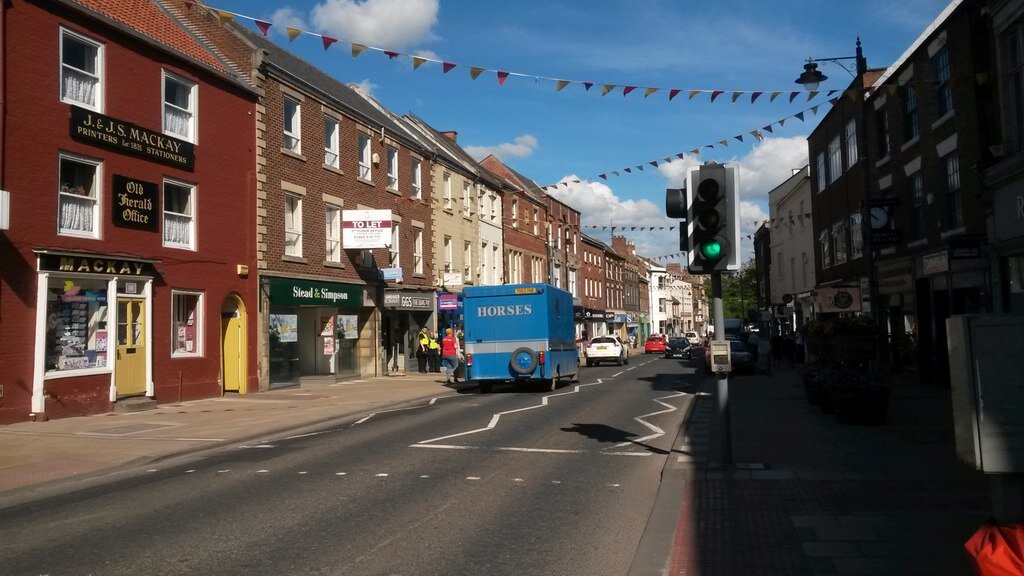
Bridge Street, Morpeth . Bridge Street is the main shopping street in Morpeth. The road is also a busy thoroughfare for traffic so a pedestrian crossing is necessary for crossing the road at busy times. © Copyright Graham Robson and licensed for reuse under the (CC BY-SA 2.0) Creative Commons Licence. https://www.geograph.org.uk/photo/3996681
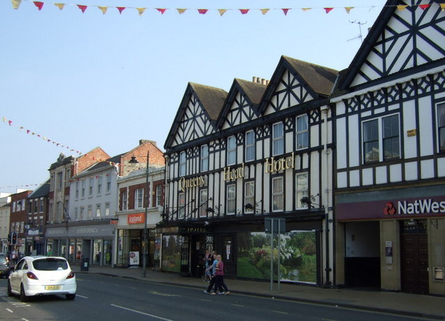
Inns in 1819: We are spoiled for choice. The Queens Head dates back to 1972 (sic) and was originally known as the Golden Fleece. The name of the pub changed to the Queens Head in 1837 to commemorate the accession of Queen Victoria to the throne.
The Queens Head Hotel, Morpeth . An old Tudor faced Coaching Inn on Bridge Street, which dates back to 1656. © Copyright JThomas and licensed for reuse under the (CC BY-SA 2.0) Creative Commons Licence. https://www.geograph.org.uk/photo/4437709
In 1877, the then proprietor, Mrs Temple, bought the old building next door and rebuilt it to extend The Queens Head into a hotel – and the ground floor today still has the original leaded windows! https://ourlocal.pub/pubs/the-queens-head-rothbury/about/ The Geograph Photograph by J Thomas, above, dates thje Inn to 1656. https://www.geograph.org.uk/photo/4437709
Another is the Waterford Lodge. Its website claims: “ This beautiful 18th century coaching inn has masses of character and charm. The Waterford Lodge Hotel is the perfect venue to celebrate your special occasion. Situated in the delightful market town of Morpeth, the Waterford Lodge really is a great location, moments from the centre of town. http://www.waterford-lodge.co.uk/
The Waterford Lodge Bar & Restaurant . © Copyright Nicholas Mutton and licensed for reuse under the (CC BY-SA 2.0) Creative Commons Licence. https://www.geograph.org.uk/photo/943723
A third is the Old Red Bull Inn. An article in The North East News dated 7 November 2011, updated 25 June 1913 reports that: “Morpeth’s Old Red Bull – which dates back to 1780 – has survived being closed by the worst flooding in the town’s history, and a severe blaze which required its rebuilding at the turn of the century.
Old Red Bull Inn, Morpeth. © Copyright Willie Duffin and licensed for reuse under the (CC BY-SA 2.0) Creative Commons Licence. https://www.geograph.org.uk/photo/1942951
But now it is set to disappear to make way for a £24m supermarket development in the Low Stanners area, where it has been a popular watering hole for more than two centuries.” http://www.thejournal.co.uk/news/north-east-news/old-red-bull-pub-morpeth-4419471
A Sun Inn was found on Geograph but its website makes no historic claims to suggest it might have been arounf in Regency times
Newcastle was England's northern fortress throughout the middle ages. Incorporated first by Henry II, the city had a new charter granted by Elizabeth in 1589. A 25-foot (7.6 m) high stone wall was built around the town in the 13th century, to defend it from invaders during the Border war against Scotland. The Scots king William the Lion was imprisoned in Newcastle in 1174, and Edward I brought the Stone of Scone and William Wallace south through the town. Newcastle was successfully defended against the Scots three times during the 14th century, and was created a county corporate with its own sheriff by Henry IV in 1400. From 1530, a royal act restricted all shipments of coal from Tyneside to Newcastle Quayside, giving a monopoly in the coal trade to a cartel of Newcastle burgesses known as the Hostmen, helping Newcastle prosper and develop into a major town. The phrase taking coals to Newcastle was first recorded contextually in 1538. The phrase itself means a pointless pursuit but in the 18th century, the American entrepreneur Timothy Dexter, regarded as an eccentric, defied this idiom. He was persuaded to sail a shipment of coal to Newcastle by merchants plotting to ruin him; however, his shipment arrived on the Tyne during a strike that had crippled local production, allowing him to turn a considerable profit.
circa 1810: South East View of Newcastle upon Tyne. Engraving drawn and engraved by J. Ryland. https://antique-prints-maps.com/acatalog/ref1.php?imagefile=../largeimages/SESEViewNewcastleRyland12.jpg
Newcastle, from the South-West. Artist W Harvey, Engraver T A Prior http://www.rareoldprints.com/z/18575
In the Sandgate area, to the east of the city, and beside the river, resided the close-knit community of keelmen and their families. They were so called because they worked on the keels, boats that were used to transfer coal from the river banks to the waiting colliers, for export to London and elsewhere. In the 1630s, about 7,000 out of 20,000 inhabitants of Newcastle died of plague, more than one-third of the population. Specifically within the year 1636, it is roughly estimated with evidence held by the Society of Antiquaries that 47% of the then population of Newcastle died from the epidemic; this may also have been the most devastating loss in any British city in this period. In the 18th century, Newcastle was the country's fourth largest print centre after London, Oxford and Cambridge, and the Literary and Philosophical Society of 1793, with its erudite debates and large stock of books in several languages, predated the London Library by half a century. Newcastle also became a glass producer with a reputation for brilliant flint glass. A permanent military presence was established in the city with the completion of Fenham Barracks in 1806. https://en.wikipedia.org/wiki/Newcastle_upon_Tyne
St James Park Newcastle as seen from south of the River Tyne by Phil Brown from Gateshead. This file is licensed under the (CC BY-SA 2.0) Creative Commons Licence. https://commons.wikimedia.org/wiki/File:St_James_Park_Newcastle_as_seen_from_south_of_the_River_Tyne.jpg
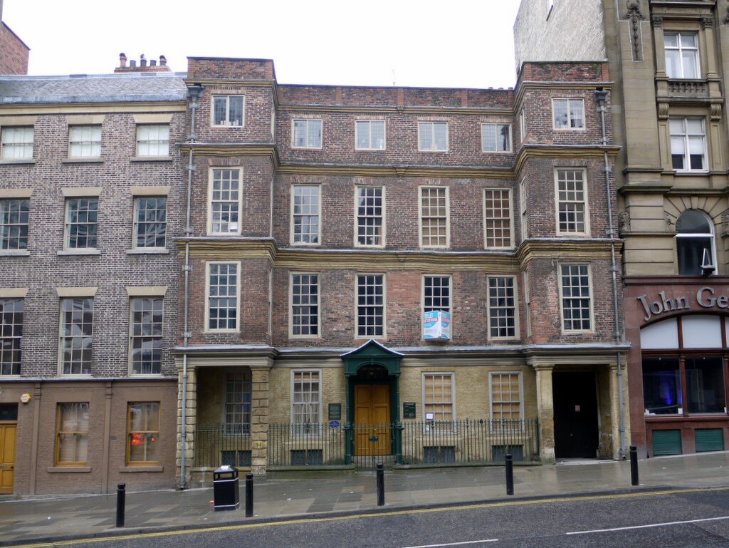
Inn: As a subtitle to the Geograph photo below, the author Andrew Curtis tells us: “A C17 merchant's house, built around 1670, and one of the oldest preserved buildings in Newcastle. Alderman Fenwick was Mayor of Newcastle in 1720. It was later a coaching inn, The Queen's Head, and, more recently, the Liberal Club. The building was restored in 1997, and is now offices. Newcastle, Pilgrim Street, No. 98, Alderman Fenwick's House” https://www.geograph.org.uk/photo/1680905
Alderman Fenwick's House, Pilgrim Street . © Copyright Andrew Curtis and licensed for reuse under the (CC BY-SA 2.0) Creative Commons Licence. https://www.geograph.org.uk/photo/1680905
Hunting for Coaching Inns in the North East: The team at Beamish, an open air museum that tells the story of life in the North East from the 1820s until the 1940s, has expanded into the Georgian area. Their article entitled “Hunting for Coaching Inns,” 20 August 2015, tells us about former coaching inn The Queen’s Head (above). “The oldest parts of Alderman’s Fenwick’s house are medieval, but the majority of house as it stands today was largely developed during the 1700s. It became prominent locally as the home of the merchant family, the Fenwicks, including Alderman Nicholas Fenwick who lived there between 1747 and 1750. By 1782 the house had been bought by Charles Turner, a local innkeeper, who began converting the building into a hotel. In 1783, Turner publicly advertised that the inn was now ‘fitted in a genteel manner’ and that it had been considerably enlarged to accommodate a dinning room, stables and coach house. Many of the features in the building date from this period of refurbishment. The inn became famous as the most fashionable in the city, holding balls and exclusive auctions and won a contract to become a posting house. Amongst its many illustrious guests was Charles Dickens.” They add: “While we were in the city, we also visited the Old George, the oldest still operating pub in Newcastle and another former coaching inn. It’s small yard still provides clues as to its former use, blocked up arches are visible in what must have been the coach house and stables.” https://beamishbuildings.wordpress.com/tag/coaching-inn/
From the website of the Old George Inn, https://www.craft-pubs.co.uk/oldgeorgeinnnewcastle
??Inncholand?? iron bridge – not found
Road Maps:
19/20 Darlington, Durham Chester le Street / Newcastle, Morpeth from Britannia Depicta Road Engraver: Emanuel Bowen (1694?–1767) http://www.rareoldprints.com/p/6997
1800: Daniel Paterson - The Road from Dalkeith to Edinburgh and the road from Morpeth to Felton continuing on the verso to Alnwick, Belford and Berwick. Published in 'Paterson' s BRITISH ITINERARY being a new and accurate Delineation and Description of the Direct and Principal Cross Roads of Great Britain in two volumes by DANIEL PATERSON Esq.' Published by Bowles & Carver in 1800. https://antique-prints-maps.com/acatalog/ref1.php?imagefile=../largeimages/MapPR221.jpg
Can you help us?
Transcription problems: As untrained transcribers we sometimes experience problems interpreting some of Lucy’s writing. We have a problem deciphering one section today:
to ??Inncholand?? to see an iron bridge - returned in the evening We have been unable to locate the iron bridge and therefore cannot confirm the name we have suggested from the transcript.
Old Regency Prints, Pictures an Coaching maps: Do you have access to any prints or pictures showing what town and country would have looked like when Lucy travelled through? Any illustrations of what she would have seen in 1819 will enliven our research.
New Pictures: Do you have any modern pictures of the streets, buildings, gardens and views that would enable us to see the changes that two centuries have wrought?


