Tuesday 2nd November 1819
Novb 2nd Tuesday. We left York early & breakfasted at Tadcaster 10 miles it is a good Inn; thence to Ferrybridge 12 miles to Doncaster 15 miles the entrance to this town by an avenue of trees is very pretty; the town is very clean & well built, there is also a handsome Gothic Church & a very excellent race ground kept in excellent order; we continued
to Barnby Moor 14 miles, Scarthing Moor 13 miles & Newark where we slept 11 miles the excellent roads & horses we had during the day enabled us to arrive at Newark to dinner, the country was very flat & uninteresting.
OBSERVATIONS & COMMENTS:
Tadcaster is a market town 3 miles east of the Great North Road, 12 miles north-east of Leeds, and 10 miles south-west of York. https://en.wikipedia.org/wiki/Tadcaster
Tadcaster - High Street (A659) , Looking south-westward from Bridge Street. © Copyright Peter Wood and licensed for reuse under the (CC BY-SA 2.0) Creative Commons Licence. https://www.geograph.org.uk/photo/6185545
Inn: In the eighteenth century mail coaches en-route to York, London, Newcastle and most other places worth travelling to passed through the town. Many of them would make use of the two fine Georgian coaching inns that graced the main street : the Angel and the White Horse.
The Angel and White Horse. Bridge Street, Tadcaster. An unusual name for a pub, with the angel being represented by a statue and the horse on a painted inn sign. The 18th century inn is listed grade 2. © Copyright Stephen Craven and licensed for reuse under the (CC BY-SA 2.0) Creative Commons Licence. https://www.geograph.org.uk/photo/5729862
In 1758 a modern brewery was built on the land behind the White Horse. The brewery - which is now known as Samuel Smith's Old Brewery - is still in production today and is Yorkshire's oldest brewery.
Tadcaster: the two breweries . The chimneys of Samuel Smith's and John Smith's breweries (left and right in this photo) dominate the town centre. John's is the more ornate, listed grade 2, although it is the later, dating from 1883, while Sam's older but plainer 18th century brewery is unlisted except for the office block. © Copyright Stephen Craven and licensed for reuse under the (CC BY-SA 2.0) Creative Commons Licence. https://www.geograph.org.uk/photo/5729932
In the 19th century the Angel was closed down and eventually the White Horse went up-market and became the Londesborough Hotel. http://greatyorkshirepubs.blogspot.com/2009/08/27-angel-and-white-horse-tadcaster.html It is probable the Coplands would have breakfasted at potentially more up-market White Horse Inn, but there may have been others in the town.
Ferrybridge is a village that lies at a historically important crossing of the River Aire which borders the North Yorkshire village of Brotherton. It is linked to other communities by the A1, which follows the route of the Great North Road. https://en.wikipedia.org/wiki/Ferrybridge
2010: The Golden Lion Public house, Ferrybridge, by Richard Kay. “I believe that the pub was used as a staging post for horse-drawn carriages using the Great North Road, when the only means of crossing the River Aire was by ferry. Yes, that is a traffic signal in the foreground; it is used by the coal barges entering and leaving the lock on the far left.” This image was taken from the Geograph project collection. The copyright on this image is owned by Richard Kay and is licensed for reuse under the (CC BY-SA 2.0) Creative Commons Attribution-ShareAlike 2.0 license. https://commons.wikimedia.org/wiki/File:The_Golden_Lion_Public_house,_Ferrybridge_-_geograph.org.uk_-_1748012.jpg
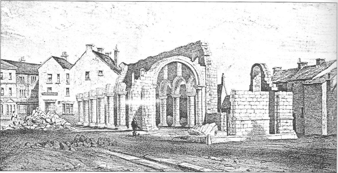
Doncaster grew up at the site of a Roman fort constructed in the 1st century at a crossing of the River Don. The main route between Lincoln and York was Ermine Street, which required parties to break into smaller units to cross the Humber in boats. As this was not always practical, the Romans considered Doncaster to be an important staging post. The Roman road through Doncaster appears on two routes recorded in the Antonine Itinerary. The itinerary entitles Routes 7 and 8 as "the route from York to London". Doncaster sat on the Great North Road or A1, due to its strategic geographical importance and essentially Roman inheritance. This was the primary route for all traffic from London to Edinburgh and Doncaster benefited from its location. In 1248, a charter was granted for Doncaster's market to be held around the Church of St Mary Magdalene, built in Norman times. In the 16th century, the church was adapted for use as the town hall. It was finally demolished in 1846.
The remains of St Mary Magdalene parish church, Doncaster, Yorkshire, during demolition in 1846, author unknown, scanned from David Hey, Medieval South Yorkshire. Public Domain. https://en.wikipedia.org/wiki/Doncaster#/media/File:St_Mary_Magdalene_Doncaster.jpg
Some 750 years on, the market continues to operate.
Market stalls by Jonathan Wilkins. Vegetable stalls outside the market hall. Doncaster market is an absolute gem, and well up the league of food provision. © Copyright Jonathan Wilkins and licensed for reuse under the (CC BY-SA 2.0) Creative Commons Licence. https://www.geograph.org.uk/photo/1724671
By 1334, Doncaster was the wealthiest town in southern Yorkshire and the sixth most important town in Yorkshire as a whole, even boasting its own banker. The borough was known for its rich landowners with vast estates and huge stately homes such as Brodsworth Hall, Cantley Hall, Cusworth Hall, Hickleton Hall, Nether Hall and Wheatley Hall (demolished 1934).
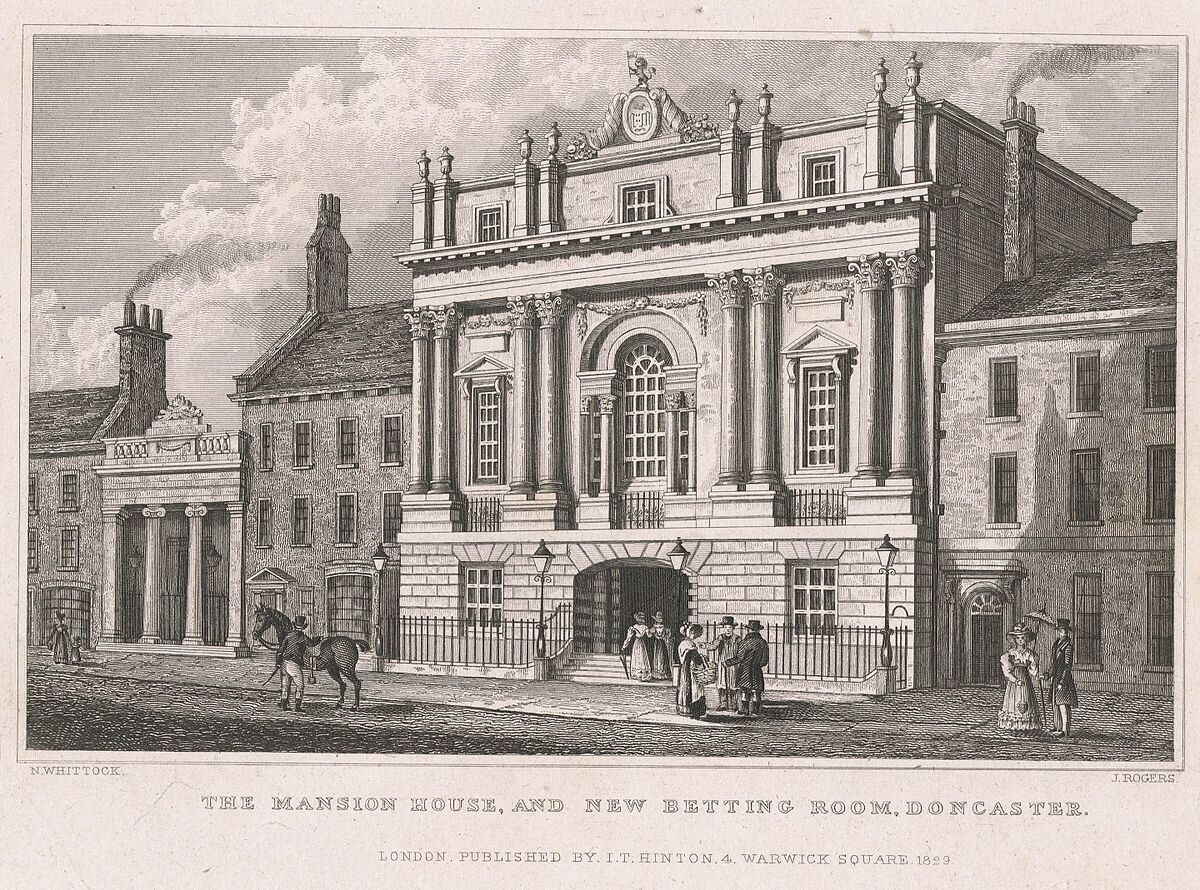
1829: Mansion House and New Betting Room, Doncaster, Nathaniel Whittock & John Rogers, published by I.T. Hinton, London, 1829. Public Domain. https://commons.wikimedia.org/wiki/File:Mansion_House_and_New_Betting_Room,_Doncaster,_Nathaniel_Whittock_%26_John_Rogers,_published_by_I.T._Hinton,_London,_1829.jpg
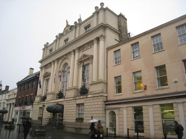
Doncaster Mansion House , by Jonathan Thacker. Built for the Mayor of Doncaster as a residence and place where he could entertain visitors. Work began on it in 1745. © Copyright Jonathan Thacker and licensed for reuse under the (CC BY-SA 2.0) Creative Commons Licence. https://www.geograph.org.uk/photo/2224331
This wealth is evidenced in the luxurious and historic gilded 18th-century Mansion House on High Street. https://en.wikipedia.org/wiki/Doncaster
Church of St George, Doncaster, also known as Doncaster Minster, occupies the same site as the Roman fort of Danum and an 18 metre stretch of the fort wall can be seen at the north east end of the Minster site. A Norman fortification is also known to have occupied the site, and it is probable that the materials from that building were used, in part, to build the early church. Jackson’s history of the Church suggests a progression from Early English to Perpendicular styles.
1805: Church of St. George, Doncaster. Sketched and engraved by B. Howlett. Published April 1st, 1805 with later hand colouring. https://antique-prints-maps.com/acatalog/ref1.php?imagefile=../largeimages/SEChurchOfStGeorge18.jpg
The destruction of the mediaeval church, by fire on the night of 28th February 1853, was seen as a great calamity for the town and the neighbourhood. This fire resulted in the loss of the medieval library which was above the south porch. Also lost was its fine Harris organ of 1739–40, which was praised by John Stanley, who declared “every pipe in the reed stops to be worth its weight in silver”. The replacement building, to the designs of George Gilbert Scott, has been described as the “proudest and most Cathedral-like of Gilbert Scott’s Parish Churches. http://www.doncasterminster.co.uk/origin-of-st-georges-church-and-its-importance-to-the-town/ Lucy would have seen the old church, shown in the 1805 Print, above, with George Gilbert Scott’s later church below.
2010: St George's Minster, Doncaster, UK , by Frees, the copyright holder of this work, who has dedicated the work to the public domain by waiving all of their rights to the work worldwide under copyright law, including all related and neighboring rights, to the extent allowed by law. You can copy, modify, distribute and perform the work, even for commercial purposes, all without asking permission. https://commons.wikimedia.org/wiki/File:St_Georges_Doncaster_3.jpg
Doncaster Racecourse (also known as the Town Moor course) is one of the oldest (and in terms of physical capacity – largest) established centres for horse racing in Britain, with records of regular race meetings going back to the 16th century. A map of 1595 already shows a racecourse at Town Moor. In 1600 the corporation tried to put an end to the races because of the number of ruffians they attracted, but by 1614 it acknowledged failure and instead marked out a racecourse.
1832: Doncaster Races... the Start of the Great St Leger Stakes , Artist James Pollard, Engraver R W Smart, C Hunt, Publisher S & J Fuller http://www.rareoldprints.com/z/10925
Doncaster is home to two of the World's oldest horse races: –The earliest important race in Doncaster's history was the Doncaster Gold Cup, first run over Cantley Common in 1766. The Doncaster Cup is the oldest continuing regulated horse race in the world. Ten years later the Racecourse moved to its present location and in 1776 Colonel Anthony St. Leger founded a race in which five horses ran. This race, The St Leger Stakes, has remained in existence and become the world's oldest classic horse race. Today the St. Leger Stakes remains the world's oldest Classic Horse Race and features in the Horse Racing calendar as the fifth and final Classic of the British Flat racing season. This takes place every September.
2013: The Grandstand and racecourse at Doncaster. Home of the St. Leger, by www.badobadop.co.uk, the copyright holder of this work, published under the (CC BY-SA 3.0) Creative Commons Attribution-Share Alike 3.0 Unported license. https://commons.wikimedia.org/wiki/File:Doncaster_Racecourse_2.jpg
https://en.wikipedia.org/wiki/Doncaster_Racecourse
Barnby Moor is a village about three miles north of East Retford. https://en.wikipedia.org/wiki/Barnby_Moor
Ye Olde Bell Hotel & Restaurant, Barnby Moor , by G Laird. The Ye Olde Bell Hotel is a 17th-century coaching inn in the Nottinghamshire village of Barnby Moor north-west of Retford. © Copyright G Laird and licensed for reuse under the (CC BY-SA 2.0) Creative Commons Licence. https://www.geograph.org.uk/photo/4705746
Scarthingmoor House is an 18th century farmhouse with large early C19 addition. It was formerly the Black Lion Inn. https://historicengland.org.uk/listing/the-list/list-entry/1045943 It lies 15 miles south of Barnby Moor and 4.3 miles from Newark. An image dated 18 June 2002 is available on this historic England link
Newark-on-Trent or Newark stands on the River Trent and on the route of the ancient Great North Road. Around 1770 the Great North Road around Newark (now the A1) was raised on a long series of arches to ensure it remained clear of the regular floods it experienced. A special Act of Parliament in 1773 allowed the creation of a town hall next to the Market Place. Designed by John Carr of York and completed in 1776, Newark Town Hall is now a Grade I listed building. In 1775 the Duke of Newcastle, at the time the Lord of the Manor and a major landowner of the area, built a new brick bridge with stone facing to replace the dilapidated one next to the castle.
Entrance to the Town of Newark-upon-Trent. Artist & Engraver Edward H. Buckler, Publisher: J.Bridges, Newark http://www.rareoldprints.com/z/1406
1827: Newark, Watercolour. View from the west, looking across the river Trent. The castle is on the left and the spire of St Mary Magdalen's church on the right. http://www.rareoldprints.com/z/13373
This is still one of the major thoroughfares in the town today. A noted advocate of reform in the late 18th century at Newark was the local-born printer and newspaper owner Daniel Holt (1766–1799). He was imprisoned for printing a leaflet advocating parliamentary reform and selling a Thomas Paine pamphlet. The Market Place is the focal point of the town. https://en.wikipedia.org/wiki/Newark-on-Trent .
Newark Market place by Bob Danylec. View of the market place & town hall, taken from the tower of Newark parish church. © Copyright Bob Danylec and licensed for reuse under the (CC BY-SA 2.0) Creative Commons Licence. https://www.geograph.org.uk/photo/73956
Newark Market Place by David Dixon. The soaring 236-feet high tower of The Church of St Mary Magdalene, Newark-on-Trent dominates the view of the northern side of Newark's Market Square. © Copyright David Dixon and licensed for reuse under the (CC BY-SA 2.0) Creative Commons Licence. https://www.geograph.org.uk/photo/3654739
In the south corner of Market Square stands what is, after the Castle and Church, the oldest building in the town, and one of the oldest domestic houses in this part of England. It was formerly the White Hart Inn, and now adjoins the modern inn of that name.
1970: Ye Olde White Hart Newark on Trent . © Copyright John Firth and licensed for reuse under the (CC BY-SA 2.0) Creative Commons Licence. https://www.geograph.org.uk/photo/1997122
The White Hart 1970, above, prior to its restoration, below.
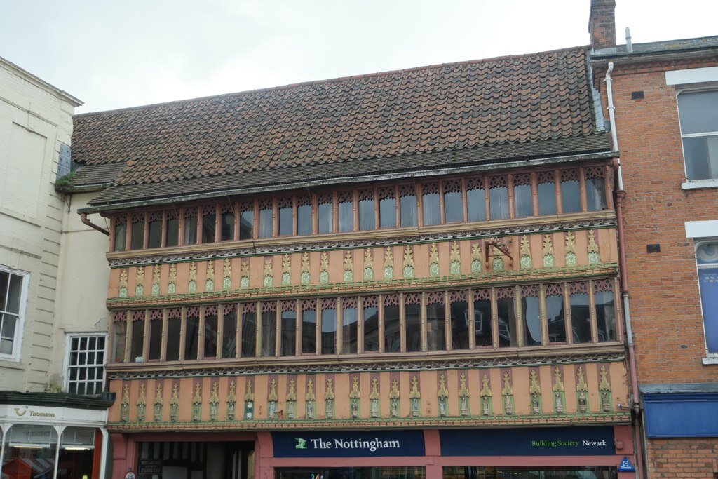
Former White Hart by Bob Harvey. Designated as a grade II* listed building the timber framed building with the characteristic arch of a Coaching Inn was known as the White Hart. The frontage here dates from 1470, though some of the rear parts of the building are up to a century older. © Copyright Bob Harvey and licensed for reuse under the (CC BY-SA 2.0) Creative Commons Licence. https://www.geograph.org.uk/photo/4722241
Along its top storey has run a continuous open gallery or cloister, now glazed in; while on the front of the first floor is a rich series of canopied niches of plaster work, those over the cart-way still retaining their figures, holding emblems, their feet supported upon hogs' masks. This house, by the character of its details, may be assigned to the middle of the fourteenth century. It is illustrated in Parker's Domestic Architecture 1859, part ii., p. 225. The visitor should step into the spacious inn yard in the rear to view the gallery, &c., from that side. Next to this building stands the Saracen's Head, where has been an inn under that name from at least the year 1341. From 1590 to 1720 it belonged to the Twentyman family, and was then the principal inn in the town.
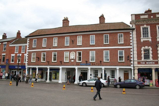
The Saracen's Head by Richard Croft. With a history dating back to 1341, the Saracen's Head Inn was once the principal coaching inn on the Great North Road at Newark. The current building dates from 1721 and like the adjacent Clinton Arms Link has a piazza of Tuscan columns facing the Market Square. King Charles reputedly stayed here on a visit to Newark and Jean Deans stayed here on her journey to London in Sir Walter Scott's novel 'The Heart of Midlothian'. It is now shops and a bank. © Copyright Richard Croft and licensed for reuse under the (CC BY-SA 2.0) Creative Commons Licence. https://www.geograph.org.uk/photo/761610
King Charles I. is said to have slept here during one of his visits to Newark, and the "blind" window in the yard, decorated with a fine example of "pargetting," or ornamental plaster work, is traditionally said to mark the bed-chamber used by the monarch. If this is so, the commemoration was executed some seventy years later, for the design of the panel is French in feeling, and of the time of Queen Anne. The "Saracen's Head " is mentioned by Sir Walter Scott in "The Heart of Midlothian" as the inn where Jeanie Deans stayed when on her journey to London. Next to the Saracen's Head comes the Clinton Arms, formerly the Kingston Arms, where Lord Byron used to stay during his visits to the town in 1806-8, when his first slender volumes of poems were printed for him by Messrs. S. and J. Ridge, who occupied the premises at the Bridge Street corner of the Market Place, now used as a grocer's shop, with the Masonic Hall above. If the visitor walks up the passage marked "Hardy's Yard" at the end of this house, he will be pleased with the long wing running out at the back, with its steep-pitched gable.
The Queen's Head by Richard Croft. Historic hostelry known as the Queen's Head until relatively recently, now owned by Wychwood Brewery and called Hobgoblin © Copyright Richard Croft and licensed for reuse under the (CC BY-SA 2.0) Creative Commons Licence. https://www.geograph.org.uk/photo/732499
The old white-washed yard is a favourite subject with local artists, as is also that under the Queen's Head, the other timbered building, near the northwest corner of the square—a quaint courtyard, which should not be missed. http://www.nottshistory.org.uk/blagg1910/marketplace.htm
Can you help us?
Old Regency Prints, Pictures an Coaching maps: Do you have access to any prints or pictures showing what town and country would have looked like when Lucy travelled through? Any illustrations of what she would have seen in 1819 will enliven our research.
New Pictures: Do you have any modern pictures of the streets, buildings, gardens and views that would enable us to see the changes that two centuries have wrought?


