26th September 1819, St Andrews Chapel, Pier, St Machar’s Cathedral, called on Professor Copland

Sunday 26th September 1819

 
LUCY 137b.jpg
 

Sunday Sept 26th We went to the English Chapel in the morning the service is excessively well performed & the chapel very well attended after church we walked to the Pier which is very fine we then attended the Scotch church which was quite full but I cannot say I admire the service so much as our own. my father was much better today and called upon Professor Copland whom we are to breakfast with tomorrow morning.


OBSERVATIONS & COMMENTS:

St Andrews Chapel: St Andrew’s Cathedral was designed in the perpendicular Gothic style by the architect Archibald Simpson, one of Simpson's many commissions in the city.

2007: Aberdeen: St. Andrews Cathedral Situated in King Street a short distance from the Mercat Cross by Chris Downer. This image was taken from the Geograph project collection. The copyright on this image is owned by Chris Downer and is licensed for…

2007: Aberdeen: St. Andrews Cathedral Situated in King Street a short distance from the Mercat Cross by Chris Downer. This image was taken from the Geograph project collection. The copyright on this image is owned by Chris Downer and is licensed for reuse under the Creative Commons Attribution-Share Alike 2.0 Generic license. (CC BY-SA 2.0) https://commons.wikimedia.org/wiki/File:Aberdeen,_St._Andrew%27s_Cathedral_-_geograph.org.uk_-_598057.jpg

While three sides of the Cathedral were built out of the usual local granite, for which Aberdeen is famous, the facade of the structure, facing King Street, was built from sandstone for economic reasons despite Simpson's opposition. The church opened in 1817 as St Andrew's Chapel and was raised to Cathedral status in 1914. https://en.wikipedia.org/wiki/St_Andrew%27s_Cathedral,_Aberdeen

The North Pier was constructed in three distinct stages as part of the major series of harbour improvements in the 18th and 19th centuries. The harbour was prone to silting so that only shallow-draught vessels could be allowed entry, larger vessels being required to lie in the 'Gawpuill' (which now forms the turning basin) at the inner end of the navigation channel. The first major works were designed by John Smeaton and carried out in 1770-81. The extended pier was 1200ft [365.9m] long and cost £180. It reduced the entry of sand into the harbour area, and changed the angle of incoming waves at the harbour entrance. The pier was further extended between 1810 and 1816 on the advice of Thomas Telford. This extension measured at least 900ft in length and ended among a group of large rocks responsible for at least five shipwrecks. https://canmore.org.uk/site/104092/aberdeen-harbour-north-pier Restricted images are found on this website of the North Pier. Below is a recent panoramic image of the harbour

2015: Aberdeen Harbour from the Air by Ragazzi99, the copyright holder of this work, and published it under the Creative Commons Attribution-Share Alike 4.0 International license. (CC BY-SA 4.0) https://commons.wikimedia.org/wiki/File:Aberdeen_Harbo…

2015: Aberdeen Harbour from the Air by Ragazzi99, the copyright holder of this work, and published it under the Creative Commons Attribution-Share Alike 4.0 International license. (CC BY-SA 4.0) https://commons.wikimedia.org/wiki/File:Aberdeen_Harbour_from_Air.jpg

Scotch Church: Probably St Machar's Cathedral, a Church of Scotland church located to the north of the city centre, in the former burgh of Old Aberdeen.

2006: St Machar's cathedral with watch house. The small house-like building was used in the 1800s to watch out for body snatchers seeking corpses for the University anatomists by Martyn Gorman. This image was taken from the Geograph project collecti…

2006: St Machar's cathedral with watch house. The small house-like building was used in the 1800s to watch out for body snatchers seeking corpses for the University anatomists by Martyn Gorman. This image was taken from the Geograph project collection. The copyright on this image is owned by Martyn Gorman and is licensed for reuse under the Creative Commons Attribution-Share Alike 2.0 Generic license. CC BY-SA 2.0 https://commons.wikimedia.org/wiki/File:St_Machar%27s_cathedral_with_watch_house_-_geograph.org.uk_-_174651.jpg

Technically, St Machar's is no longer a cathedral but rather a high kirk, as it has not been the seat of a bishop since 1690. After the execution of William Wallace in 1305, his body was cut up and sent to different corners of the country to warn other dissenters. His left quarter ended up in Aberdeen and is buried in the walls of the cathedral. https://en.wikipedia.org/wiki/St_Machar%27s_Cathedral

Professor Patrick Copland, 1749-1822, is reputed to be the cousin of Alexander Copland (1736-93), Lucy’s paternal Grandfather, who also hailed from Aberdeen. We don’t know the name of Alexander’s father or birth place so Patrick may even have been a brother and therefore Lucy’s great uncle. The exact connection has not been established, but a familial link is favoured by the family calling upon him, his wife Elizabeth, their daughter Mary and their son, also called Alexander. This was a favoured first name, with Alexander being the names of the first (1749-1822), the second (Lucy’s father), the third (Lucy’s brother Alex) and the fourth Alex’s son Alexander Lester Copland where the male line died out.

The son of Rev. Samuel Copland, Patrick was born at the manse of Fintray, a village about 12 miles from Aberdeen by road. In 1762, he won a bursary to Marischal College in Aberdeen where he was taught Mathematics under Prof John Stewart and Natural Philosophy under Prof George Skene. In 1774 Patrick became assistant to Prof George Skene and in 1775 became a professor of Mathematics at Marischal, remaining there and in 1779 advancing to the role of professor of Natural Philosophy, which he held until 1817. He is known to have been an associate of the Linnean Society. He was a co-founder of the Royal Society of Edinburgh in 1783 and, as a keen astronomer, was responsible for building the Castlehill Observatory in Aberdeen. He was a pioneer of the use of demonstration equipment (much of his own design) to explain the principles of mathematics and physics. In 1783, Patrick was accused of being accused of involvement in the "Black Arts" through his numerous experiments with electricity at the Observatory, "drawing mischief out of the clouds with his electric batteries". In 1803 he purchased Fountainhall House in Aberdeen (now 130 Blenheim Place) from his former mentor, Prof George Skene, and this remained his home until death. https://en.wikipedia.org/wiki/Patrick_Copland

Patrick was also a consultant physicist and advised the town on fresh water supplies, sand and gravel filtration beds and surveying. He also helped record the first measurements of the Deeside hills using barometrics and was instrumental in the introduction of chlorine bleach to Britain. He was officially honoured by the town for his involvement with Aberdeen's Water Supply. His massive contribution to public health is described in detail in: http://www.mcjazz.f2s.com/PatrickCopeland.htm

Patrick is also remembered as a pioneer of public education, introducing in 1785 a series of popular extra-mural classes in the city, classes which ran until 1813. These pre-dated the mechanics’ institute movement of the 1820s and have been credited with influencing the founding of London’s Royal Institution in 1800. Over the course of his career, Copland taught over 2,000 students. He was a popular and dedicated teacher whose services were recognised in 1817 when he was awarded an honorary LLD by his college. But perhaps his greatest contribution to university education was the introduction of demonstration apparatus in teaching natural philosophy. He was passionate about mechanical science, and even ran and equipped his own workshop where skilled tradesmen and craftsmen were employed in the production of items in wood and metal. Many of these instruments survive to this day in the University’s Natural Philosophy and Marischal Museum collections. In 1776, a petition was drawn up and signed by the entirety of Copland’s first year class, requesting that the public examination be carried out in “our native language” and not, as was the case at that time, in Latin: “The public examination we apprehend is intended to prove what proficiency we have made in Natural Philosophy, not in the Latin tongue”. The main instigator was believed to be a Londoner, James Stephen, the grandfather of the founder of the Dictionary of National Biography and great-grandfather of Virginia Woolf. Stephen kept a memoir in which he surmised that as Patrick himself was not proficient in Latin, the petition might in fact be welcomed. Whatever the reception, the students’ request was acceded to after deliberation by the principal and professors. https://www.abdn.ac.uk/special-collections/professor-patrick-copland-453.php

Can you help us?

Old Regency Prints, Pictures an Coaching maps: Do you have access to any prints or pictures showing what town and country would have looked like when Lucy travelled through? Any illustrations of what she would have seen in 1819 will enliven our research.

New Pictures: Do you have any modern pictures of the streets, buildings, gardens and views that would enable us to see the changes that two centuries have wrought?

25th September 1819, Brothers to Theatre Royal

Saturday 25th September 1819

 
LUCY 136c.jpg
 
LUCY 137a.jpg
 

Saturday Sept 25th We remained at Aberdeen my Father was very unwell the whole of the day my brothers went to

the theatre in the evening, which is very small.


OBSERVATIONS & COMMENTS:

Father Unwell: We know from notes in his diaries that Alexander Copland suffered from chronic gout. Below is a Meissen porcelain statue of a husband with gout being nursed by his wife and child from the Wellcome Collection of images. The intense pain of gout could not be avoided by the family and this compassionate composition shows their little daughter looking up at her father’s anguish as she holds a bowl from which her mother fills a cloth with water or some lotion, perhaps of colchicum, to soothe her father’s pain.

Porcelain statue by Meissen in Germany of a man experiencing gout being nursed by his wife. "Science Museum, London" Attribution 4.0 International (CC BY 4.0) https://wellcomecollection.org/works/c6a367b3/items

Porcelain statue by Meissen in Germany of a man experiencing gout being nursed by his wife. "Science Museum, London" Attribution 4.0 International (CC BY 4.0) https://wellcomecollection.org/works/c6a367b3/items

The Wellcome Collection provides an invaluable commentary on Gillray’s depiction of gout, below, written in the context of Lucy’s day: Gout is an intensely painful disease of the joints of the fingers and toes, and sometimes other joints. In traditional western medicine it is associated with the infusion or drip (Latin gutta, hence the English word gout) of wet humours (phlegm and/or blood) into the cavity of a damaged organ. Although it was regarded by many as incurable, there was a demand for treatments, which included a diet designed to rebalance the proportion of humours in the body as a whole, and bloodletting positioned to draw blood away from the gouty organ. Some students of gout theorized that there was a "morbid humour" specific to gout, and, a corresponding specific remedy which God had placed in the plant colchicum, the metal gold, or some other substance. In 1848, a year of revolutions in Europe, such a "morbid humour" was indeed identified as a naturally occurring chemical, uric acid. In another period of rapid change, the 1960s, a corresponding remedy was found when staff at the Burroughs Wellcome laboratories in the USA discovered the medicine allopurinol As Porter and Rousseau point out, Gillray's print The gout (1799) is unique in restricting its focus to the diseased organ. There are dozens of other Georgian and earlier prints of gouty people, but they all show the whole patient in a social context. Gillray's depiction isolates the painful organ from the tragi-comedy of manners surrounding the disease: the face of the sufferer, the furnishings of the room, and the friends offering comfort are all excluded, perhaps representing the ability of the disease to block out everything else from the victim's mind https://wellcomecollection.org/works/cnvaa8sc

1799: J Gillray The Gout - Coloured soft-ground etching by J. Gillray. Wellcome Collection-Attribution 4.0 International (CC BY 4.0). https://wellcomecollection.org/works/cnvaa8sc

1799: J Gillray The Gout - Coloured soft-ground etching by J. Gillray. Wellcome Collection-Attribution 4.0 International (CC BY 4.0). https://wellcomecollection.org/works/cnvaa8sc

Gout was considered to be an affliction of the wealthier classes and associated with rich food, especially liver, and alcohol, overindulgence in port being considered one of the popular primary causes. It was the subject of much lampooning by the caricaturists of the day, with the 1818 print by G Cruikshank depicting a man gorging himself on rich food and drink as a devil places hot coals on his foot. The picture on the wall of Vesuvius erupting represents the imminent contraction of gout.

1818: Introduction of the gout by G. Cruikshank, after Captain Simon Hehl. Wellcome Collection. Creative Commons Attribution (CC BY 4.0) https://iiif.wellcomecollection.org/image/V0010850.jpg/full/760,/0/default.jpg

1818: Introduction of the gout by G. Cruikshank, after Captain Simon Hehl. Wellcome Collection. Creative Commons Attribution (CC BY 4.0) https://iiif.wellcomecollection.org/image/V0010850.jpg/full/760,/0/default.jpg

There was no cure, but the 1799 print below by Gillray ironically illustrates sufferers of the gout, the colic and the tisick (archaic for a cough) seeking solace from a bowl of punch.

1799: Gillray - Punch cure the Gout the Colic, - and the Tisick. A caricature by James Gillray first published by H. Humphreys on July 13th, 1799. https://antique-prints-maps.com/acatalog/ref1.php?imagefile=../largeimages/GilrayTisickCollic.JPG

1799: Gillray - Punch cure the Gout the Colic, - and the Tisick. A caricature by James Gillray first published by H. Humphreys on July 13th, 1799. https://antique-prints-maps.com/acatalog/ref1.php?imagefile=../largeimages/GilrayTisickCollic.JPG

Theatre Royal in Marischal Street, Aberdeen was opened in 1795 and was the first permanent Theatre to have been built in Aberdeen. The Theatre cost £3,000 to construct and could seat up to 600 people when it first opened under its original Manager Stephen Kemble. The Theatre was designed by Henry Holland, who had just completed the designs for the third Theatre Royal, Drury Lane which had opened a year earlier in 1794. The Aberdeen Theatre Royal was actually a conversion from a former house built by John Jackson, who had started its construction in 1788 but had become bankrupt before the building could be completed. Stephen Kemble bought the House in 1794 and with the aid of his subscribers, each paying £25, was able to roof over the original building and fit up the inside as a Theatre. Although Kemble had built the Theatre he didn't stay as its Manager for very long and soon a string of lesser Managers were trying there hand at running the Theatre. In 1799 someone called Bell was Managing it, then in 1802 Hamilton, and next a Mr. Beaumont, who was soon getting into trouble with rent payments and was replaced by Mr. and Mrs. Mudie who had the same problem by 1811. Later Managers were Fraser in 1812, and then Corbet Ryder who ran it until 1842. http://www.arthurlloyd.co.uk/Aberdeen.htm Today the building is the Elim Pentecostal Church, who have a picture of the building on their website at http://www.elimaberdeen.com/ The picture below is taken from Google Street View, captured in March 2019, shows the size of the theatre that Lucy records as being very small.

Can you help us?

Old Regency Prints, Pictures an Coaching maps: Do you have access to any prints or pictures showing what town and country would have looked like when Lucy travelled through? Any illustrations of what she would have seen in 1819 will enliven our research.

New Pictures: Do you have any modern pictures of the streets, buildings, gardens and views that would enable us to see the changes that two centuries have wrought?

24th September 1819, Aberdeen, Union Street, Kings College

Friday 24th September 1819

 
LUCY 136b.jpg

Friday Sepbr 24th After breakfast we started for Aberdeen 16 miles where we arrived about 1 o’clock we then walked out to see the town which consists of old & new Aberdeen the chief street is Union street where Dumfosters hotel (which is a very good) one is situated in this street it is nearly a mile in length & the houses very regularly built the other streets are narrow, the chief structure is the King College none of the other principal buildings are at all striking: Papa & Alexander, who had left us at Huntly to transact some business at the village of Leith returned late in the evening


OBSERVATIONS & COMMENTS:

Aberdeen received Royal burgh status from David I of Scotland (1124–1153), transforming the city economically. The city's two universities, the University of Aberdeen, founded in 1495, and Robert Gordon University, which was awarded university status in 1992, make Aberdeen the educational centre of the north-east of Scotland. During the mid-18th to mid-20th centuries, Aberdeen's buildings incorporated locally quarried grey granite, which can sparkle like silver because of its high mica content. In 1647 an outbreak of bubonic plague killed a quarter of the population. In the 18th century, a new Town Hall was built and the first social services appeared with the Infirmary at Woolmanhill in 1742 and the Lunatic Asylum in 1779.

1772-90: Perspective View of New Aberdeen in the County of Aberdeen or Marn from The complete English traveller, or A new survey and description of England and Wales 1772-1790. http://www.rareoldprints.com/z/545

1772-90: Perspective View of New Aberdeen in the County of Aberdeen or Marn from The complete English traveller, or A new survey and description of England and Wales 1772-1790. http://www.rareoldprints.com/z/545

The council began major road improvements at the end of the 18th century with the main thoroughfares of George Street, King Street and Union Street all completed at the beginning of the 19th century. The expensive infrastructure works led to the city becoming bankrupt in 1817 during the Post-Napoleonic depression, an economic downturn immediately after the Napoleonic Wars; but the city's prosperity later recovered. https://en.wikipedia.org/wiki/Aberdeen

Union Street is a major street and shopping thoroughfare in Aberdeen, named after the Acts of Union 1800 with Ireland. It was built to relieve the strain of the small, cramped streets that caused problems for people coming into the city. It was built higher than the old town and was designed to include the five entrances from the city: Queens Road - Rubislaw from Hazelhead; George Street from Inverurie and Morayshire; King Street from the north from Bridge Of Don, Peterhead and Fraserburgh; Market Street, which leads to the fishing town of Torry; and Holburn Street to the Ruthrieston and Garthdee areas. Designed in the beginning of the 19th century under plans suggested by Charles Abercrombie, it nearly bankrupted the city.

2003: Union Street from the Citadel Taken from the Aberdeen citadel looking over the Castlegate and down Union Street , by Lyn Mcleod. This image was taken from the Geograph project collection. The copyright on this image is owned by Lyn Mcleod and …

2003: Union Street from the Citadel Taken from the Aberdeen citadel looking over the Castlegate and down Union Street , by Lyn Mcleod. This image was taken from the Geograph project collection. The copyright on this image is owned by Lyn Mcleod and is licensed for reuse under the Creative Commons Attribution-Share Alike 2.0 Generic license. https://commons.wikimedia.org/wiki/File:UnionStreet-287149-Lyn_Mcleod.jpg

The Denburn River still runs under Union Bridge but has been covered over by a dual carriageway road. The street is 0.8 miles long (Lucy says “nearly a mile”) and a feat of engineering skill involving the partial levelling of St. Catherine's Hill and the building of arches to carry the street over Putachieside. Union Street crossed the Denburn Valley by Union Bridge (constructed 1801–05) and holds the record of the 'Worlds largest single span granite bridge' at 130 feet (40 m) across. https://en.wikipedia.org/wiki/Union_Street,_Aberdeen

Dumfosters Hotel: No such hotel is listed in Hotel History of Aberdeen, a very comprehensive review of old Aberdeen hotels. http://www.mcjazz.f2s.com/HotelHistory.htm Lucy records that it was on Union Street. Hotel History records New Inn 1755 ~1839 (Anderson's Hotel) but it was on Castle Street. The next hotel listed chronologically is the The Athenaeum or Union Buildings, built 1819-22 on Union Street, but it was designed as a Reading and Newsroom for the Citizens of Aberdeen and only became a hotel and Restaurant when it was sold in 1888. The next hotel was built in 1835 as the Aberdeen Hotel, later the Victoria Restaurant.

The University and King's College of Aberdeen (Collegium Regium Abredonense), was founded in 1495 and is now an integral part of the University of Aberdeen. Its historic buildings are the centrepiece of the University of Aberdeen's Old Aberdeen campus, often known as the King's or King's College campus.

2010: King's College, Aberdeen by Nick Bramhall from Aberdeen. This file is licensed under the Creative Commons Attribution-Share Alike 2.0 Generic license. This image was originally posted to Flickr by Nick Bramhall at https://flickr.com/photos/537…

2010: King's College, Aberdeen by Nick Bramhall from Aberdeen. This file is licensed under the Creative Commons Attribution-Share Alike 2.0 Generic license. This image was originally posted to Flickr by Nick Bramhall at https://flickr.com/photos/53725815@N00/4315559621. It was reviewed on 28 March 2017 by FlickreviewR and was confirmed to be licensed under the terms of the cc-by-sa-2.0. https://commons.wikimedia.org/wiki/File:King%27s_College,_Aberdeen_(4315559621).jpg

The focal point of the college, as well as its oldest building, is the late 15th century King's College Chapel.

2013: Aberdeen: King's College Chapel by Mussklprozz, the copyright holder, and published under the Creative Commons Attribution-Share Alike 3.0 Unported license. https://commons.wikimedia.org/wiki/File:AberdeenKingsCollegeChapel_2013-08.jpg

2013: Aberdeen: King's College Chapel by Mussklprozz, the copyright holder, and published under the Creative Commons Attribution-Share Alike 3.0 Unported license. https://commons.wikimedia.org/wiki/File:AberdeenKingsCollegeChapel_2013-08.jpg

A number of other historic buildings remain, with others being subject to renovation and rebuilding in the 18th and 19th centuries. King's College Chapel is the main chapel used by the University of Aberdeen. Forming the north side of the original quadrangle of King's College, construction of the chapel began in 1498 and ended with the consecration of the building in 1509. The Chapel’s most notable architectural feature is its Crown Tower, an icon of the university as a whole. https://en.wikipedia.org/wiki/King%27s_College,_Aberdeen

Village of Leith: There does not appear to be a village named Leith and although Lucy may have misspelled the town of Keith (see 22nd September) her father and Alex possibly transacted their business at Leith Hall in the village of Kennethmont, 8 miles south of Huntly.

Leith Hall was built in 1650, on the site of the medieval Peill Castle, and was the home of the Leith-Hay family for nearly three centuries. Since 1945 it has been run by the National Trust of Scotland (NTS). Leith Hall is set in a 286-acre estate with scenic gardens. https://en.wikipedia.org/wiki/Leith_Hall

2009: Leith Hall (rear elevation) For its history, see: http://www.undiscoveredscotland.co.uk/rhynie/leithhall/index.html . Photograph by Bill Harrison. This image was taken from the Geograph project collection. The copyright on this image is owned …

2009: Leith Hall (rear elevation) For its history, see: http://www.undiscoveredscotland.co.uk/rhynie/leithhall/index.html . Photograph by Bill Harrison. This image was taken from the Geograph project collection. The copyright on this image is owned by Bill Harrison and is licensed for reuse under the Creative Commons Attribution-Share Alike 2.0 Generic license. https://commons.wikimedia.org/wiki/File:Leith_Hall_(rear_elevation)_-_geograph.org.uk_-_1273765.jpg

Can you help us?

Hotel: Was there a Dumfosters Hotel in Union Street in 1819?

Old Regency Prints, Pictures an Coaching maps: Do you have access to any prints or pictures showing what town and country would have looked like when Lucy travelled through? Any illustrations of what she would have seen in 1819 will enliven our research.

New Pictures: Do you have any modern pictures of the streets, buildings, gardens and views that would enable us to see the changes that two centuries have wrought?

23rd September 1819, Huntly for breakfast, Huntly Lodge, Castle, Inn to change horses, Inverury

Thursday 23rd September 1819

 
LUCY 135b.jpg
 
LUCY 136a.jpg
 

Thursday Sepbr 23rd Left Leith before breakfast & advanced to Huntly a small town the Inn tolerable after breakfast walked to Huntly lodge the seat of the Marquis of Huntly a small comfortable house this dwelling is prettily furnished the garden & grounds are small but the ancient ruins of Huntly Castle form a pretty object: we then

proceeded to ??Pitinadrie ?? Inn 8 miles where changing horses we advanced to Inverury 9 miles to dinner a small town with a neat & most comfortable Inn


OBSERVATIONS & COMMENTS:


Huntly is the historic home of the Gordon Highlanders https://en.wikipedia.org/wiki/Huntly

1992: Gordon Square, Huntly, by Colin Smith. This image was taken from the Geograph project collection. The copyright on this image is owned by Colin Smith and is licensed for reuse under the Creative Commons Attribution-Share Alike 2.0 Generic lice…

1992: Gordon Square, Huntly, by Colin Smith. This image was taken from the Geograph project collection. The copyright on this image is owned by Colin Smith and is licensed for reuse under the Creative Commons Attribution-Share Alike 2.0 Generic license. https://commons.wikimedia.org/wiki/File:Gordon_Square,_Huntly.jpg


Huntly Arms: Between 1700 and the early 19th century, many changes were made to the shape and buildings of the Huntly Arms. The Marquis of Huntly took a personal interest in the development and commercial activities of the ‘inn at Aboyne’, but in the early 1800s left the management more in the hands of Alexander Sanderson who added the Baronial Hall section – the current function suite with bedrooms on two floors – to serve as his private quarters. This is the southern wing, which protrudes into the garden. https://www.huntlyarmshotel.com/history/

From the website of the Huntly Arms Hotel https://www.huntlyarmshotel.com/gallery/

From the website of the Huntly Arms Hotel https://www.huntlyarmshotel.com/gallery/

We are not sure whether this was the Inn Lucy thought was “tolerable” - The family would visit the best hotels in the town, here to have breakfast and rest the horses, and we are surprised that an inn as grand as the Huntly Arms would not have gained greater credit from Lucy than this throwaway comment.

Huntly Lodge was built by the 4th Duke of Gordon 7th Marquess of Huntly; 1st Earl of Norwich in the 18th century. Here, in 1787, the 75thRegiment, the forerunner of the 1st battalion The Gordon Highlanders, was raised for service in the Far East, but it was not until 1793 when the French Revolutionary Government had declared war on Great Britain that the Government asked the Duke of Gordon to raise another regiment. On the 24th June, 1794 the newly embodied regiment was paraded for the first time at Aberdeen when they wore the then almost new, and now famous, Gordon Regimental tartan which had been devised by Forsythe of Huntly http://www.scotshistoryonline.co.uk/lodgehunt.html

Huntly Lodge is now the Castle Hotel, Huntly http://www.castlehotel.uk.com/

Now the Castle Hotel, Huntly. This image is from the Hotel’s website http://www.castlehotel.uk.com/

Now the Castle Hotel, Huntly. This image is from the Hotel’s website http://www.castlehotel.uk.com/

Huntly Castle. A mound in the grounds of the castle is all that remains of an earlier 12th century motte. Originally named Strathbogie, the castle was granted to Sir Adam Gordon of Huntly in the 14th century. King Robert the Bruce was a guest of the castle in 1307 prior to his defeat of the Earl of Buchan. Although burned to the ground in 1452, a grander castle was built in its place. In 1496, the pretender to the English throne, Perkin Warbeck, was married to Lady Catherine Gordon the daughter of George Gordon, 2nd Earl of Huntly, witnessed by King James IV of Scotland at Edinburgh.

c. 1830: Castle Huntly, from the South. Engraving by R. Scott after R. Dick. https://antique-prints-maps.com/acatalog/ref1.php?imagefile=../largeimages/SECastleHuntleyFromS13.jpg

c. 1830: Castle Huntly, from the South. Engraving by R. Scott after R. Dick. https://antique-prints-maps.com/acatalog/ref1.php?imagefile=../largeimages/SECastleHuntleyFromS13.jpg

By the early 18th century the castle was already in decay and provided material for predatory house builders in the village.

2002: Huntly Castle, view from near main entrance, by Lyall Duffus. This image was taken from the Geograph project collection. The copyright on this image is owned by Lyall Duffus and is licensed for reuse under the Creative Commons Attribution-Shar…

2002: Huntly Castle, view from near main entrance, by Lyall Duffus. This image was taken from the Geograph project collection. The copyright on this image is owned by Lyall Duffus and is licensed for reuse under the Creative Commons Attribution-Share Alike 2.0 Generic license. https://commons.wikimedia.org/wiki/File:Huntly_Castle.jpg

In 1746, during a later Jacobite rising, it was occupied by British government troops, then becoming a common quarry until a groundswell of antiquarian sentiment in the 19th century came to its rescue https://en.wikipedia.org/wiki/Huntly_Castle

Inn at ??Pitinadrie?? See request for help, below

Inverury is said to have been founded by David of Huntingdon, Earl of the Garioch, brother of Malcolm IV, great-great-grandfather of Robert the Bruce who defeated John Comyn, 3rd Earl of Buchan nearby at the Battle of Barra in May 1308. The religious foundation pre-dates this by five centuries with the establishment of the Kirk of Inverurie now known as St Andrew's Parish Church. https://en.wikipedia.org/wiki/Inverurie

2005: Across the flood plain of the River Urie Taken from the B 9170 looking south west across the grid square, by Lizzie. This image was taken from the Geograph project collection. The copyright on this image is owned by Lizzie and is licensed for …

2005: Across the flood plain of the River Urie Taken from the B 9170 looking south west across the grid square, by Lizzie. This image was taken from the Geograph project collection. The copyright on this image is owned by Lizzie and is licensed for reuse under the Creative Commons Attribution-Share Alike 2.0 Generic license. https://commons.wikimedia.org/wiki/File:Inverurie-Panorama.jpg

Inn at Inverury not known

Can you help us?

Transcription problems: As untrained transcribers we sometimes experience problems interpreting some of Lucy’s writing. We have a problem deciphering a section today:

LUCY 136a-extract.jpg

proceeded to ??Pitinadrie ?? Inn 8 miles where changing horses We could find no clues as to the name of this inn 8 miles out of Huntly on the road to Inverury. Help would be appreciated.

Old Regency Prints, Pictures an Coaching maps: Do you have access to any prints or pictures showing what town and country would have looked like when Lucy travelled through? Any illustrations of what she would have seen in 1819 will enliven our research.

New Pictures: Do you have any modern pictures of the streets, buildings, gardens and views that would enable us to see the changes that two centuries have wrought?

22nd September 1819, Elgin, Cathedral, Priory, River Spey, Fochabers, Gordon Castle, Keith

Wednesday 22nd September 1819

 
LUCY 134b.jpg
 
LUCY 135a.jpg
 

Wednesday 22d Sept We breakfasted at Elgin 8 miles from Forres having passed over a flat pretty country Elgin is a small town & the Inn good; it is remarkable for the Cathedral, a magnificent ruin built in the 14 century; there is also the ruin of a priory here; thence to Fochabers 9 miles passing through a road of fine trees & a bridge thrown over the river Spey on entering this place we arrived

at the entrance of the Duke of Gordons; having walked nearly a mile through a most beautiful park we stopped at the castle a very grand fine building I was disappointed in the interior the rooms which are very numerous are of a moderate size plainly furnished & the pictures which adorn them are chiefly family portraits, the gardens are very extensive. Fochabers is a small town and the Inn appears good; thence to Keith 8 miles a small town the Inn tolerable there is a nice church here….


OBSERVATIONS & COMMENTS:

Elgin: In August 1040, MacBeth's army defeated and killed Duncan I at Bothganowan (Pitgaveny), near Elgin. Elgin is first recorded in a charter of David I in 1151 in which he granted an annuity to the Priory of Urquhart. Elgin was a popular residence for the early Scottish monarchs.

2006: View of Elgin Cathedral with River Lossie in foreground, taken by Bill Reid at English Wikipedia and licensed under the Creative Commons Attribution-Share Alike 2.5 Generic, 2.0 Generic and 1.0 Generic license. https://commons.wikimedia.org/wi…

2006: View of Elgin Cathedral with River Lossie in foreground, taken by Bill Reid at English Wikipedia and licensed under the Creative Commons Attribution-Share Alike 2.5 Generic, 2.0 Generic and 1.0 Generic license. https://commons.wikimedia.org/wiki/File:Elgin_cathedral_2.jpg

On 19 July 1224, the foundation stone of the new Elgin Cathedral was ceremoniously laid. https://en.wikipedia.org/wiki/Elgin,_Moray

Part of Elgin Cathedral, Murrayshire, Scotland. Aquatint engraved and published by F J Sarjent after Thomas Walmsley. http://www.rareoldprints.com/z/19306

Part of Elgin Cathedral, Murrayshire, Scotland. Aquatint engraved and published by F J Sarjent after Thomas Walmsley. http://www.rareoldprints.com/z/19306

Fochabers was founded in 1776, and is one of the best examples of a planned village. https://en.wikipedia.org/wiki/Fochabers

2003: Fochabers village, beside the River Spey, by Qeqertaq, the copyright holder of this work, and published under the Creative Commons Attribution-Share Alike 3.0 Unported license. https://commons.wikimedia.org/wiki/File:Fochabers_and_the_Spey.JPG

2003: Fochabers village, beside the River Spey, by Qeqertaq, the copyright holder of this work, and published under the Creative Commons Attribution-Share Alike 3.0 Unported license. https://commons.wikimedia.org/wiki/File:Fochabers_and_the_Spey.JPG

The River Spey is unusual in that its speed increases as it flows closer to the sea, due to a broadly convex long-profile. The mean flow is around 16 metres per second (36 mph) making it the fastest flowing river in Scotland. https://en.wikipedia.org/wiki/River_Spey

2005: River Spey at Aberlour, by Anne Burgess. This image was taken from the Geograph project collection. The copyright on this image is owned by Anne Burgess and is licensed for reuse under the Creative Commons Attribution-ShareAlike 2.0 license. h…

2005: River Spey at Aberlour, by Anne Burgess. This image was taken from the Geograph project collection. The copyright on this image is owned by Anne Burgess and is licensed for reuse under the Creative Commons Attribution-ShareAlike 2.0 license. https://commons.wikimedia.org/wiki/File:River_Spey.jpg

Gordon Castle and Park was completed as one of Scotland’s largest houses in the 1770s by the Duke of Gordon, Gordon Castle is the spiritual home of the House of Gordon, one of Scotland’s oldest families.

The estate nestles in the Spey valley, in the heart of whisky country, with a stretch of the Spey River running through the estate, which boasts some of the best salmon fishing in the world Today, the Estate offers exclusive use accommodation in the Castle, self-catering holiday cottages, world-class salmon fishing, Walled Garden visitor attraction, natural children’s play area and a café serving delicious fresh food from the garden and local suppliers. https://www.gordoncastle.co.uk/our-story/ The Gordon Castle website includes a YouTube video https://www.youtube.com/watch?time_continue=79&v=bOIZrxoW7L4 entitled A view, a brew and a loo; breathing life into a traditional Scottish Estate

The Gordon Arms Hotel is a former coaching inn based in the attractive village of Fochabers, in Moray, and has served guests for over 200 years. http://www.gordonarms.co.uk/

Keith dates to around 1180 where the Old Town still remains, now almost indistinguishable from the rest of the town. It developed around the old bridge which was built there by two mourning parents as a permanent memorial to their dear child who drowned in the river at that crossing point in the hope that none should suffer similar loss.

2005: Auld Brig, Old Bridge in Keith, Banffshire, Scotland by , Kcampbell, the copyright holder, at English Wikipedia, and published under the Creative Commons Attribution-Share Alike 3.0 Unported license. https://commons.wikimedia.org/wiki/File:Kei…

2005: Auld Brig, Old Bridge in Keith, Banffshire, Scotland by , Kcampbell, the copyright holder, at English Wikipedia, and published under the Creative Commons Attribution-Share Alike 3.0 Unported license. https://commons.wikimedia.org/wiki/File:Keithauldbrig.jpg

The main part of the town is on higher ground above the river, laid out around 1750 by the Earl of Findlater. The language spoken indigenously round Keith is Doric, which superseded Scottish Gaelic https://en.wikipedia.org/wiki/Keith,_Moray

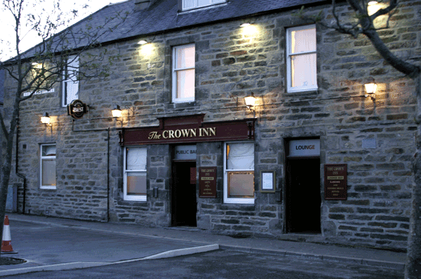
Inn: Possibly the Crown Inn http://www.thecrowninnkeith.com/

Image from the Crown Inn website http://www.thecrowninnkeith.com/

Image from the Crown Inn website http://www.thecrowninnkeith.com/

The Church: St Rufus was built in 1819 to cater for the new town. The former parish church was in the old churchyard at Auld Toun near the River Isla and dated back to mediaeval times. It was rebuilt in 1569 and then abandoned in 1819 when the new church was built.

2005: Church in Keith, Banffshire, Scotland , by Kcampbell at English Wikipedia, the copyright holder of this work, and published it under the Creative Commons Attribution-Share Alike 3.0 Unported license. https://commons.wikimedia.org/wiki/File:Kei…

2005: Church in Keith, Banffshire, Scotland , by Kcampbell at English Wikipedia, the copyright holder of this work, and published it under the Creative Commons Attribution-Share Alike 3.0 Unported license. https://commons.wikimedia.org/wiki/File:Keithchurch.jpg

Lucy finds a “nice church” and it is probably this newly built church she visited. http://strufus.org/churches.php

Can you help us?

Old Regency Prints, Pictures an Coaching maps: Do you have access to any prints or pictures showing what town and country would have looked like when Lucy travelled through? Any illustrations of what she would have seen in 1819 will enliven our research.

New Pictures: Do you have any modern pictures of the streets, buildings, gardens and views that would enable us to see the changes that two centuries have wrought?

21st September 1819, Cawdor Castle, Durnaway Castle, trees of Macbeth’s witches, Forres

Tuesday 21st September 1819

 
LUCY 133b.jpg
 
LUCY 134a.jpg
 

Tuesday Sept 21st After breakfast we went to Cawdor Castle where we were shown the room in which Duncan was sleeping when he was murdered by Macbeth the bed in which he was killed was formerly shown but from the carelessness of the steward this valuable relict was burnt about two years ago our guide (a curious old woman) who lamented this loss excessively gave us a bit of Duncan’s sofa & bed which she had saved at the time of the accident & showed us the alarm bell which was rung on the discovery of the murder; the inhabited part of the castle built in the 15 century is nothing very striking; thence

to Durnaway Castle the seat of the Earl of Moray passing on our way a clump of trees on a large heath which denote the spot where the Witches as is fabulously related appeared to Macbeth Durnaway Castle is a large modern uncomfortable house in an unfinished state there is a large hall here built by Lord Randolph in the 14 century 100 feet long & very lofty it is able to contain a 1000 men under arms; we then proceeded 4 miles to Forres a pretty town in a romantic situation the new Inn is very good.


OBSERVATIONS & COMMENTS:

Cawdor Castle: Two sketches from Lucy’s sketchbook dated 21st September 1819

Approaching Cawdor Castle - Lucy’s sketchbook, 21st September 1819

Approaching Cawdor Castle - Lucy’s sketchbook, 21st September 1819

Cawdor Castle - Lucy’s sketchbook, 21st September 1819

Cawdor Castle - Lucy’s sketchbook, 21st September 1819

Cawdor Castle is built around a 15th-century tower house, with substantial additions in later centuries. Originally a property of the Calder family, it passed to the Campbells in the 16th century and remains in Campbell ownership.

1901: Cawdor Castle, Scotland by R W Billings, from The Baronial and Ecclesiastical Antiquities of Scotland. This work is in the public domain in its country of origin and other countries and areas where the copyright term is the author's life plus …

1901: Cawdor Castle, Scotland by R W Billings, from The Baronial and Ecclesiastical Antiquities of Scotland. This work is in the public domain in its country of origin and other countries and areas where the copyright term is the author's life plus 70 years or fewer. https://commons.wikimedia.org/wiki/File:Cawdor-Castle_2.jpg

1799: Cawdor Castle. Engraving by J. Walker from an original drawing by James Moore F.A.S. published in "The Itinerant" .. https://antique-prints-maps.com/acatalog/ref1.php?imagefile=../largeimages/SECawdorC.JPG

1799: Cawdor Castle. Engraving by J. Walker from an original drawing by James Moore F.A.S. published in "The Itinerant" .. https://antique-prints-maps.com/acatalog/ref1.php?imagefile=../largeimages/SECawdorC.JPG

The castle is perhaps best known for its literary connection to William Shakespeare's tragedy Macbeth, in which the title character is made "Thane of Cawdor". However, the story is highly fictionalised, and the castle itself, which is never directly referred to in Macbeth, was built many years after the life of the 11th-century King Macbeth. https://en.wikipedia.org/wiki/Cawdor_Castle

Judging from Lucy’s vivid account of seeing the room in which Duncan was murdered, the alarm bell that was rung at the time and the Guide’s provision of part of the sofa and bed on which he died (presumably for a generous fee) one can only believe that she, and perhaps the rest of the family, believed what they were told. However the castle was not built until after Duncan’s death.

2009: Cawdor Castle in the Scottish Highland, UK by LeCardinal , the copyright holder of this work, published under the Creative Commons Attribution-Share Alike 3.0 Unported license. https://commons.wikimedia.org/wiki/File:Ecosse2009127.JPG


2009: Cawdor Castle in the Scottish Highland, UK by LeCardinal , the copyright holder of this work, published under the Creative Commons Attribution-Share Alike 3.0 Unported license. https://commons.wikimedia.org/wiki/File:Ecosse2009127.JPG

Darnaway Castle: The banqueting hall is the only remaining portion of the castle. It was erected in 1450 by Archibald Douglas, Earl of Moray, and retains its 15th-century hammer beam roof, making it one of only two medieval halls in Scotland with its original roof, "a specimen almost unique in Scotland."

1804: Scotia Depicta - Tarnaway Castle - Etching by James Fittler after a drawing by John Claude Nattes in the collection of the National Library of Scotland under the sequence number or Shelfmark ID J.134.f. This work is in the public domain in its…

1804: Scotia Depicta - Tarnaway Castle - Etching by James Fittler after a drawing by John Claude Nattes in the collection of the National Library of Scotland under the sequence number or Shelfmark ID J.134.f. This work is in the public domain in its country of origin and other countries and areas where the copyright term is the author's life plus 100 years or fewer. https://commons.wikimedia.org/wiki/File:Scotia_Depicta_-_Tarnaway_Castle_-Plate-.jpg

The hall was already notable in 1562 when an English observer described it as, "verie fayer and large builded" The hall was re-roofed with "spune thak", wooden shingles or shakes hewn by a carpenter, in November 1501 at the command of James IV of Scotland. James kept his mistress Janet Kennedy at Darnaway. Lucy incorrectly dates it to the 14th century. https://en.wikipedia.org/wiki/Darnaway_Castle

The photograph below shows the building of 1810. Behind it is the earlier 16th century Randolph's Hall, which boasts a fine hammer beam roof, and the portrait of the murdered 'Bonnie Earl o' Moray'.

1990: Darnaway Castle. Photographer Anne Burgess.This image was taken from the Geograph project collection. The copyright on this image is owned by Anne Burgess and is licensed for reuse under the Creative Commons Attribution-ShareAlike 2.0 license.…

1990: Darnaway Castle. Photographer Anne Burgess.This image was taken from the Geograph project collection. The copyright on this image is owned by Anne Burgess and is licensed for reuse under the Creative Commons Attribution-ShareAlike 2.0 license. https://commons.wikimedia.org/wiki/File:Darnaway_Castle_-_geograph.org.uk_-_13190.jpg

Forres is the location of Sueno's Stone, an enormous carved stone probably created by Picts to commemorate a battle against Norse invaders. The stele is 20 feet tall and encased in glass structure to protect it from the elements and graffiti.

2005: Sueno's Stone: Pictish symbol stone on the north-easterly edge of Forres, Moray, Scotland by Wojsyl at English Wikipedia, the copyright holder, and published under the Creative Commons Attribution-Share Alike 3.0 Unported license. https://comm…

2005: Sueno's Stone: Pictish symbol stone on the north-easterly edge of Forres, Moray, Scotland by Wojsyl at English Wikipedia, the copyright holder, and published under the Creative Commons Attribution-Share Alike 3.0 Unported license. https://commons.wikimedia.org/wiki/File:Forres_sueno.jpg

Sueno's Stone translates to Sven's Stone. Brodie Castle lies near the town. Shakespeare's play Macbeth locates Duncan's castle in Forres, and the Three Witches meet on a heath near the town in the third scene of the drama. https://en.wikipedia.org/wiki/Forres

2004: Forres High Street, photographed and edited by A M Wilson and released into the public domain by its author, Amwilson2000 at English Wikipedia. https://commons.wikimedia.org/wiki/File:ForresHighStreet.JPG

2004: Forres High Street, photographed and edited by A M Wilson and released into the public domain by its author, Amwilson2000 at English Wikipedia. https://commons.wikimedia.org/wiki/File:ForresHighStreet.JPG

The Inn: Possibly the Castle Inn https://canmore.org.uk/site/172793/forres-29-caroline-street-the-castle

Can you help us?

Old Regency Prints, Pictures an Coaching maps: Do you have access to any prints or pictures showing what town and country would have looked like when Lucy travelled through? Any illustrations of what she would have seen in 1819 will enliven our research.

New Pictures: Do you have any modern pictures of the streets, buildings, gardens and views that would enable us to see the changes that two centuries have wrought?

20th September 1819, Gentlemen to Fort George, Lucy and Mama to Nairn, Moray Firth, Castle Stuart, Culloden Heat

Monday 20th September 1819

 
LUCY 132e.jpg
 
LUCY 133a.jpg
 

Monday 20th Sept Mr Laury and Dr MacDonald who attended Mama breakfasted with us; who being much better today we started at 1 o’clock from Inverness the gentleman lengthened their ride by going around to Fort George but Mama and myself went

straight to Nairn 18 miles the road lies close to the Murray Firth at the head of which stands Fort George, Castle Stuart apparently a ruin Culloden Heath where that memorable battle was fought where the only things we passed on the road Nairn is a pretty neat town the Inn is good


OBSERVATIONS & COMMENTS:

Dr MacDonald at Breakfast: Kristen Koster, in her article entitled A Primer on Regency Era Doctors, https://www.kristenkoster.com/primer-regency-era-doctors/ explains the social status enjoyed by physicians, thereby accounting for the presence of Dr MacDonald at the family Breakfast Table in Bennett’s Hotel:

During the Regency, physicians occupied the highest rung on the social ladder. Because of their extra schooling and lack of apprenticeship, physicians were considered gentleman. These men did not practice a trade and the profession avoided manual labor. Physicians simply diagnosed patients and wrote prescriptions, but they didn’t dispense drugs.

Physicians often received social invitations from the families they treated. They would dine with the families or spend the night as a guest. Other practitioners ate with the servants, if required. Although all three were doctors, surgeons and apothecaries were addressed as “Mister”, because only those who qualified as physicians could use the title of “Doctor”.

The print below illustrates a seated Physician with a stick as he talks to the patient - there was probably very little physical contact with the patient at the consultation.

c.1835: A young lady reclining, being attended by a physician. Lithograph, Paris, by de Lemercier, Benard et Cie. From The Wellcome Collection (Creative Commons Attribution 4.0 International) . https://wellcomecollection.org/works/m9pqnsm4

c.1835: A young lady reclining, being attended by a physician. Lithograph, Paris, by de Lemercier, Benard et Cie. From The Wellcome Collection (Creative Commons Attribution 4.0 International) . https://wellcomecollection.org/works/m9pqnsm4

Fort George was built in the wake of the Battle of Culloden (1746) as a secure base for King George II’s army. It was designed by Lieutenant-General William Skinner and built by the Adam family of architects. Fort George took 22 years to complete, by which time the Jacobite threat had subsided. But it has served the British Army for the almost 250 years since. https://www.historicenvironment.scot/visit-a-place/places/fort-george/

2006: Fort George Following the defeat of Bonnie Prince Charlie at Culloden, King George II built the ultimate defence against further unrest - Fort George. Photograph by Stephen Branley. This image was taken from the Geograph project collection. Th…

2006: Fort George Following the defeat of Bonnie Prince Charlie at Culloden, King George II built the ultimate defence against further unrest - Fort George. Photograph by Stephen Branley. This image was taken from the Geograph project collection. The copyright on this image is owned by Stephen Branley and is licensed for reuse under the Creative Commons Attribution-Share Alike 2.0 Generic license. https://commons.wikimedia.org/wiki/File:Fort_George_-_geograph.org.uk_-_1242152.jpg

THE VISIT BY THE COPLAND GENTLEMEN IS OF SIGNIFICANCE AS LUCY’S FATHER, ALEXANDER COPLAND, MADE HIS FORTUNE BUILDING MILITARY ESTABLISHMENTS DURING THE NAPOLEONIC WAR - See Lucy’s Father

The fortifications form an example of defence in depth. The main walls are stone-faced, in plan faceted and angled with projecting bastions and redoubts so that every wall face is covered by fire from guns sited on top of other walls. The walls are many yards wide and grassed over, on top of barrel-vaulted casemates which form underground bunkers designed to protect the entire garrison from artillery fire.

2005: Some of the defences at Fort George, Scotland. Showing the famous "Pepperpot" defences. Taken by Flaxton, the copyright holder of this work, and released into the public domain. From the English Wikipedia .https://commons.wikimedia.org/wiki/Fi…

2005: Some of the defences at Fort George, Scotland. Showing the famous "Pepperpot" defences. Taken by Flaxton, the copyright holder of this work, and released into the public domain. From the English Wikipedia .https://commons.wikimedia.org/wiki/File:Fort_george_turret.jpg

2007: This is a rampart in Fort George, Highlands, by Akinom, the copyright holder of this work, and published it under the Creative Commons Attribution-Share Alike 3.0 Unported license. https://commons.wikimedia.org/wiki/File:Fort_George,_Highland-…

2007: This is a rampart in Fort George, Highlands, by Akinom, the copyright holder of this work, and published it under the Creative Commons Attribution-Share Alike 3.0 Unported license. https://commons.wikimedia.org/wiki/File:Fort_George,_Highland-rampart.JPG

The approach to the fortress from the landward side is across a wide area of loose shingle which creates a protective barrier. Sloping grassy banks designed to absorb artillery shells all but hide the fort from view.

2008: Photograph of the sole surviving 64 pounder 64 cwt Mk I rifled muzzle-loading gun, mounted on a replica carriage. At the Duke of Cumberland's bastion at Fort George, Inverness, Scotland. Photograph by Ronnie Leask. This image was taken from th…

2008: Photograph of the sole surviving 64 pounder 64 cwt Mk I rifled muzzle-loading gun, mounted on a replica carriage. At the Duke of Cumberland's bastion at Fort George, Inverness, Scotland. Photograph by Ronnie Leask. This image was taken from the Geograph project collection. The copyright on this image is owned by Ronnie Leask and is licensed for reuse under the Creative Commons Attribution-Share Alike 2.0 Generic license. https://commons.wikimedia.org/wiki/File:RML_64_pounder_64_cwt_Mk_I_gun_Fort_George_979165_cbfc8f8a-by-ronnie-leask.jpg

1992: 13-inch Sea Service (SS) Mortar at Fort George. Fort George was built after the '45 Rebellion. It was sited at the opposite end of the road from Fort William through the Great Glen. Photograph by Colin Smith. This image was taken from the Geog…

1992: 13-inch Sea Service (SS) Mortar at Fort George. Fort George was built after the '45 Rebellion. It was sited at the opposite end of the road from Fort William through the Great Glen. Photograph by Colin Smith. This image was taken from the Geograph project collection. The copyright on this image is owned by Colin Smith and is licensed for reuse under the Creative Commons Attribution-ShareAlike 2.0 license. https://commons.wikimedia.org/wiki/File:Mortar_at_Fort_George._-_geograph.org.uk_-_115142.jpg

The entrance is reached via a ravelin, a free-standing defensive structure incorporating a guardhouse and completely exposed to fire from the main fort, then by a raised wooden walkway, complete with drawbridge, bridging across a wide ditch set between heavily defended bastions. The ditch forms a wide killing ground openly exposed to gunfire from these walls.

2006: The Chapel at Fort George by John Clive Nicholson. This image was taken from the Geograph project collection. The copyright on this image is owned by John Clive Nicholson and is licensed for reuse under the Creative Commons Attribution-Share A…

2006: The Chapel at Fort George by John Clive Nicholson. This image was taken from the Geograph project collection. The copyright on this image is owned by John Clive Nicholson and is licensed for reuse under the Creative Commons Attribution-Share Alike 2.0 Generic license. https://commons.wikimedia.org/wiki/File:The_Chapel_at_Fort_George_-_geograph.org.uk_-_231979.jpg

2017: Fort George, Scotland by Pjt56, the copyright holder of this work, and published under the Creative Commons Attribution-Share Alike 4.0 International license. https://commons.wikimedia.org/wiki/File:FortGeorge-pjt4.jpg

2017: Fort George, Scotland by Pjt56, the copyright holder of this work, and published under the Creative Commons Attribution-Share Alike 4.0 International license. https://commons.wikimedia.org/wiki/File:FortGeorge-pjt4.jpg

The barracks are still in use as a military establishment, but much of the site is open to the public (entrance charge). Historic Environment Scotland use part of one of the barracks to display reconstructions of life in the early days of the fort, and the Grand Magazine displays the Seafield Collection of Arms as well as forming a stage for actors recreating the lives and stories of soldiers in the 18th century.[12] The site received 71,906 visitors during 2018 https://en.wikipedia.org/wiki/Fort_George,_Highland

Nairn: King James VI of Scotland visited the town in 1589 and is said to have later remarked that the High Street was so long that the people at either end spoke different languages, Scots and Gaelic. The narrow-streeted fishertown surrounds a harbour built by Thomas Telford.

Nairn Harbour - Sunset over the marina in Nairn Harbour - by Valenta, the copyright holder, and licensed for reuse under the Attribution-ShareAlike 2.0 Generic Creative Commons Licence. https://www.geograph.org.uk/photo/6056851

Nairn Harbour - Sunset over the marina in Nairn Harbour - by Valenta, the copyright holder, and licensed for reuse under the Attribution-ShareAlike 2.0 Generic Creative Commons Licence. https://www.geograph.org.uk/photo/6056851

It was not until the 1860s that Nairn became a respectable and popular holiday town. https://en.wikipedia.org/wiki/Nairn

Moray Firth is a roughly triangular inlet (or firth) of the North Sea, north and east of Inverness. It is the largest firth in Scotland, stretching from Duncansby Head (near John o' Groats) in the north and Fraserburgh in the east, to Inverness and the Beauly Firth in the west. https://en.wikipedia.org/wiki/Moray_Firth

2006: South Kessock pier. Looking NNE across Beauly Firth; Ord Hill Fort in right background, by Iain Macaulay. This image was taken from the Geograph project collection. The copyright on this image is owned by Iain Macaulay and is licensed for reus…

2006: South Kessock pier. Looking NNE across Beauly Firth; Ord Hill Fort in right background, by Iain Macaulay. This image was taken from the Geograph project collection. The copyright on this image is owned by Iain Macaulay and is licensed for reuse under the Creative Commons Attribution-Share Alike 2.0 Generic license. https://commons.wikimedia.org/wiki/File:South_Kessock_pier_-_geograph.org.uk_-_124266.jpg

Castle Stuart is a 17th century tower house. Completed in 1625, the castle initially flourished. It fell into disuse as the fortunes of the House of Stuart sank during the English Civil War and Charles I was executed.

Castle Stuart. N.W. Engraving by J.H. Le Keux after Robert William Billings published in 'The Baronial and Ecclesiastical Antiquities of Scotland' between 1847 - 52. https://antique-prints-maps.com/acatalog/ref1.php?imagefile=../largeimages/SECastle…

Castle Stuart. N.W. Engraving by J.H. Le Keux after Robert William Billings published in 'The Baronial and Ecclesiastical Antiquities of Scotland' between 1847 - 52. https://antique-prints-maps.com/acatalog/ref1.php?imagefile=../largeimages/SECastleStuartNW15.jpg

The castle lay derelict for 300 years before being restored as a luxury hotel. https://web.archive.org/web/20091231051406/http://www.castlestuart.com/history.html

Culloden Moor: In the battle on April 16 1746 the last Scottish army was destroyed by the British army. Although they possessed numerous artillery pieces and fired more balls per man than the British they had no more than 200 mounted men; the British had almost four times as many.

The Battle of Culloden, 1746, oil on canvas, by David Morier, from the Royal Collection Trust. This is a faithful photographic reproduction of a two-dimensional, public domain work of art which is in the public domain in its country of origin. https…

The Battle of Culloden, 1746, oil on canvas, by David Morier, from the Royal Collection Trust. This is a faithful photographic reproduction of a two-dimensional, public domain work of art which is in the public domain in its country of origin. https://commons.wikimedia.org/wiki/File:The_Battle_of_Culloden.jpg

Once the Jacobite front line failed to break the British front at more than one point, their reinforcements were readily disrupted by British cavalry and dragoons on the wings, and the ensuing disorder led to collapse.

2007: The Well of the Dead, Culloden Moor The commander of the Clan Chattan regiment, Alasdair MacGillivray of Dunmaglass, and many other Jacobite soldiers died here after engaging the left wing of the Hanoverian army. Photograph by Euan Nelson. Thi…

2007: The Well of the Dead, Culloden Moor The commander of the Clan Chattan regiment, Alasdair MacGillivray of Dunmaglass, and many other Jacobite soldiers died here after engaging the left wing of the Hanoverian army. Photograph by Euan Nelson. This image was taken from the Geograph project collection. The copyright on this image is owned by Euan Nelson and is licensed for reuse under the Creative Commons Attribution-Share Alike 2.0 Generic license. https://commons.wikimedia.org/wiki/File:The_Well_of_the_Dead,_Culloden_Moor_-_geograph.org.uk_-_494157.jpg

2005: A panorama of the battlefield of the Battle of Culloden. The battle was fought in 1746, between Jacobite forces and the British Army. On the left side of the photograph the flag shows the location of the Jacobite line, and on the right side of…

2005: A panorama of the battlefield of the Battle of Culloden. The battle was fought in 1746, between Jacobite forces and the British Army. On the left side of the photograph the flag shows the location of the Jacobite line, and on the right side of the photograph shows the location of the British Army line. Photograph by Auz, originally posted to Flickr as Culloden Battlefield. This file is licensed under the Creative Commons Attribution-Share Alike 2.0 Generic license. https://commons.wikimedia.org/wiki/File:Panorama_of_the_Battle_of_Culloden.jpg

Inn at Nairn – not located

Can you help us?

Inn at Nairn: We would love to know what inns were open in 1819. Lucy records that it is good.

Old Regency Prints, Pictures an Coaching maps: Do you have access to any prints or pictures showing what town and country would have looked like when Lucy travelled through? Any illustrations of what she would have seen in 1819 will enliven our research.

New Pictures: Do you have any modern pictures of the streets, buildings, gardens and views that would enable us to see the changes that two centuries have wrought?

19th September 1819, Inverness, Mama bad cold

Sunday 19th September 1819

 
LUCY 132c.jpg
 

Sunday Sept 19th we remained at Inverness I did not go to church on account of Mama who was very unwell with a bad cold Mr Laury a particular friend of my father’s dined with us.


OBSERVATIONS & COMMENTS:

Bad Cold: Although there were medical advances in the Georgian and Regency eras, traditional medical concepts remained very much as they had in previous centuries, some dating back to Galen (129-210), the Greek physician, surgeon and philosopher who led medical advancements in the Roman Empire. The modern understanding of hygiene were not to gain acceptance until the middle/late Victorian era. Indeed, many pioneering doctors and medical philosophers found themselves lampooned in the caricatures of T Rowlandson and James Gillray.

Scientific Researches! New Discoveries in Pneumatics!or an Experimental Lecture on the Powers of the Air by James Gillray and published by Henry G. Bohn in 1849. It was originally published by H.Humphrey in 1803, probably under the title: Germans Ea…

Scientific Researches! New Discoveries in Pneumatics!or an Experimental Lecture on the Powers of the Air by James Gillray and published by Henry G. Bohn in 1849. It was originally published by H.Humphrey in 1803, probably under the title: Germans Eating Sour-Krout http://www.rareoldprints.com/z/2585

The Gillray cartoon, above, is likely to be lampooning the likes of Dr Thomas Beddoes, founder in 1799 of the Pneumatic Institution at Dowry Square, Hotwells, Bristol, who explored treating disease, especially tuberculosis, by the inhalation of various gases, which he called pneumatic medicine.

Maria Grace in Regency Life sets the scene in her article Regency Medicine: Betwixt and Between https://randombitsoffascination.com/2017/03/04/rename-a-touch-of-consumption-by-kyra-cornelius-kramer/
In In Vanessa Riley's Regency Reflections blog of 28 January 2013, http://christianregency.com/blog/2013/01/28/curing-the-cough-and-soothing-the-sniffles/ , Kristi writes: “The scientific study of medicine was just coming into existence as the Regency rolled around. Knowledge of germs and nutrition and the importance of cleanliness were mere inklings of ideas in the heads of the most advanced medical minds of the time. And these men (for they were almost exclusively men) were often scoffed at for their new ideas and practices. Because medicine was still working to organize and legitimize itself, healthcare fell on the shoulders of the people, or more specifically the women. Cookbooks of the day would contain recipes for home remedies that could be mixed or cooked to aid the ailing.Mothers would also pass down time-honored practices for various diseases, leaving people at the time with a mix of rudimentary science, folk remedy, and medieval traditions. Physicians were so rare and costly that one had to be very rich or near death to call upon one. So how did they handle the fevers and the sniffles. Without decongestants and pain relievers, they were forced to take to their beds for however long it took the body to overcome the bacteria or virus. Because many congestion related disorders were thought to be brought on by cold or damp conditions, sick rooms were often kept warm and dry, with little to no air circulation. The old axiom “Feed a cold, starve a fever” was also prescribed to, with some ailing patients being restricted to diets of bread and water in the hopes of purging the bodies of the disease. Some households would have knowledge of herbs and be able to ease the pain with concoctions of willow bark tea while others preferred to drink themselves into oblivion until the worst of the illness had passed. Other interesting treatments of the time included inducing copious amounts of sweating, stuffing orange rinds up the nose, and colonic irrigation, or cleansing of the bowels. http://christianregency.com/blog/2013/01/28/curing-the-cough-and-soothing-the-sniffles/

A Cure for the Cold from the Wellcome Foundation - Creative Commons Attribution (CC BY 4.0) https://iiif.wellcomecollection.org/image/V0011172.jpg/full/760,/0/default.jpg

A Cure for the Cold from the Wellcome Foundation - Creative Commons Attribution (CC BY 4.0) https://iiif.wellcomecollection.org/image/V0011172.jpg/full/760,/0/default.jpg

Perhaps the most through research on coughs and colds is from Katherine Allen’s Curing Coughs and the Common Cold in Eighteenth-Century England https://recipes.hypotheses.org/2723 . Katherine completed her doctorate in the history of medicine and science at the University of Oxford in 2015. Her research is on elite healthcare and household medicine in eighteenth-century England, and her doctoral thesis is titled 'Manuscript Recipe Collections and Elite Domestic Medicine in Eighteenth-Century England'.

Katherine writes “In the eighteenth century catching cold was linked to climate. In his popular work Domestic Medicine (1772 edition) William Buchan explained that catching cold was a result of ‘obstructed perspiration’ and that the secret to not getting sick was avoiding extremes in temperature. Buchan observed that, ‘the inhabitants of every climate are liable to catch cold, nor can even the greatest circumspection defend them against its attacks’. For treatment Buchan advised rest, fluids, light foods, and an infusion of balm and citrus. He also cautioned that ‘Many attempt to cure a cold, by getting drunk. But this, to say no worse of it, is a very hazardous and fool-hardy experiment.’ … "Newspapers were an excellent source for cough and cold remedies; the Weekly Amusement (February 4, 1764), for instance, had a remedy ‘A Plaister for a Sore Throat’. Made from melted mutton suet, rosin, and beeswax, this paste was spread on a cloth and pinned on from ear to ear. Newspaper clippings were also pasted into manuscripts. ...Letters indicate the regularity of which remedies were exchanged, and document how individual’s expressed their cold symptoms. Mrs Gell thanked her sisters for ‘ye receipt which I believe very good in [this] time of yeare’ adding ‘thanke God & ye Drs skill & care & friends nursing am very well againe my cough is gon[e] & I am about house’. In another case, Judith Madan wrote to her daughter giving details of an illness and declared ‘My Cough is less violent and comes seldemer. As for the Phlegm which has been my torme[n]t, it must have time to subside.’

“A variety of cough and cold remedies were featured in recipe books. Alongside restorative broths (like modern chicken soup), artificial asses’ milk, and milk-based diets in general, were associated with treating coughs …. Topical therapies were also used, such as Emily Jane Sneyd eighteenth-century version of VapoRub; a mixture of sweet almond oil and syrup of violets along with a plaster of candle wax, saffron, and nutmeg applied to the stomach. Syrups and electuaries were popular remedies. One seventeenth-century recipe, ‘a most excellent electuary given to Lady Lisle by Dr Lower’, was a mixture including conserve of red roses, balsam of sulphur, oil of vitriol, and syrup of coltsfoot. Opiates were common in cough remedies, for sedation. Mrs Cotton suggested a mixture of liquorice, vinegar, salad oil, treacle, and tincture of opium when ‘the cough is troublesome’. Finally, lozenges were used to alleviate sore throats. Elizabeth Jenner’s recipe book (1706) includes her own method of making lozenges ‘very good for Coughs Comeing by takeing Cold’. Jenner’s method involved creating a stiff paste of sugar, herbal oils and powders, and rose water, rolling out the paste, punching out rounds with a thimble, and then drying them in the oven. These treatment examples reflect the variety of sources available for medical advice. As the case of the common cold demonstrates, individuals were opportunistic by collecting and trialling new remedies, while also relying on standby cures. Kith and kin were proactive in exchanging remedies and were not shy about discussing their conditions, including ‘tormenting phlegm’. But, despite an arsenal of remedies, advice for the common cold in eighteenth-century England appears strikingly similar to our current approach: stay home, rest, forego partying for a few days, and perhaps try some cough syrup."

Considering that Lucy’s mother was up and about tomorrow she would have rested up today, perhaps taken some relatively harmless syrup and would have enjoyed the luxury and comfort of Bennett’s Hotel. We learn tomorrow that she also had the benefit of Dr MacDonald, who was to breakfast with the family before the family set out from Inverness with Lucy and her mother sensibly taking it easy by going straight on to Nairn whilst the men had a more active day.

Inverness: As the family is returning on the road they came, for Inverness see our blogs for: September 4th 1819, September 5th 1819, September 6th 1819 and September 7th 1819 to review the city

Bennett’s hotel: The family remained in Inverness and would have stayed in the luxurious surroundings of the Bennett’s Hotel that they enjoyed on September 4th 1819, 5th and 6th September 1819


Can you help us?

Old Regency Prints, Pictures an Coaching maps: Do you have access to any prints or pictures showing what town and country would have looked like when Lucy travelled through? Any illustrations of what she would have seen in 1819 will enliven our research.

New Pictures: Do you have any modern pictures of the streets, buildings, gardens and views that would enable us to see the changes that two centuries have wrought?

18th September 1819, Remained at Inverness

Saturday 18th September 1819

 
LUCY 132b.jpg

Saturday Sept 18th Remained at Inverness


OBSERVATIONS & COMMENTS:

Inverness: As the family is returning on the road they came, for Inverness see our blogs for: September 4th 1819, September 5th 1819, September 6th 1819 and September 7th 1819 to review the city

Bennett’s hotel: The family remained in Inverness and would have stayed in the luxurious surroundings of the Bennett’s Hotel that they enjoyed on September 4th 1819, 5th and 6th September 1819

Can you help us?

Old Regency Prints, Pictures an Coaching maps: Do you have access to any prints or pictures showing what town and country would have looked like when Lucy travelled through? Any illustrations of what she would have seen in 1819 will enliven our research.

New Pictures: Do you have any modern pictures of the streets, buildings, gardens and views that would enable us to see the changes that two centuries have wrought?

17th September 1819, Dingwall, Falls of Kilmorack, the Dhruim, river Glass, Inverness

Friday 17th September 1819

 
LUCY 131e.jpg
 
LUCY 132a.jpg
 

Friday Sept 17th we breakfasted this morning at Dingwall thence to Beauly where we went in the

to see the Fall of Kilmorack a short distance from the town the fall is very insignificant but the situation romantically fine in an immense chasm of rock we then road three miles further to see a vale called the Dhruim abounding with romantic scenery the rocks river Glass winding beautifully through drooping trees at the bottom we then returned & proceeded to Inverness where we arrived at 6 o’clock.


OBSERVATIONS & COMMENTS:

Falls of Kilmorack are on the river Beauly, 2 miles southwest of the village, occurring between Kilmorack hamlet on the North bank and the ruined church and burying-ground of Kiltarlity on the South bank of the river.

0917 view near the fall of Q.Shilmorach Invernesshire.jpg

Above, Lucy’s sketch “View of the fall near Kilmorack Inverness-shire” - Lucy is correct when annotating her sketch but the print, below, c 1840: Falls of Kilmorack, Beauly, Ross-shire, after T Allom is incorrect with Ross-shire.

c 1840: Falls of Kilmorack, Beauly, Ross-shire. Scotland. After T Allom https://www.amazon.co.uk/Falls-Kilmorack-Beauly-Ross-shire-Scotland/dp/B01LX4ZOTN

c 1840: Falls of Kilmorack, Beauly, Ross-shire. Scotland. After T Allom https://www.amazon.co.uk/Falls-Kilmorack-Beauly-Ross-shire-Scotland/dp/B01LX4ZOTN

They are remarkable not so much for their height as for their breadth and volume. For fully half a mile above the lower fall the river has cut a deep and narrow channel through Old Red sandstone conglomerate, and at the bottom of this it toils in a series of rapids alternating with sullen, deep brown pools full of mysterious eddies. At one place the opening is very narrow, and the water has a sheer fall of some 15 feet, which is known as the upper fall. Immediately below this narrow rocky channel the banks suddenly expand into a wide semi-circular basin, through which the river slowly glides till, at the lower edge, it falls over a series of low rocky shelves in miniature cascades, boiling and fretting upon the uneven bed as it rushes onward. The tops of the rocky banks of both sides are covered with birch and pine trees. The best points of view are from a summerhouse in the minister's garden on the North bank and from the walk along the South bank within the premises of Beaufort Castle, to which a bridge immediately below the falls crosses. http://www.scottish-places.info/parishes/parhistory275.html

2008: Loch nam Bonnach near Kilmorack by Sylvia Duckworth. This image was taken from the Geograph project collection. The copyright on this image is owned by Sylvia Duckworth and is licensed for reuse under the Creative Commons Attribution-ShareAlik…

2008: Loch nam Bonnach near Kilmorack by Sylvia Duckworth. This image was taken from the Geograph project collection. The copyright on this image is owned by Sylvia Duckworth and is licensed for reuse under the Creative Commons Attribution-ShareAlike 2.0 license.https://commons.wikimedia.org/wiki/File:Loch_nam_Bonnach_-_geograph.org.uk_-_693004.jpg

The Beauly river was first bridged in about 1817, when Thomas Telford constructed the five arched Lovat Bridge about 1 km south west of Beauly. This bridge carried the A9, the main route north, until the Kessock Bridge was opened in 1982. A railway bridge across the river on the outskirts of Beauly was built in the 1860s to carry the Inverness & Ross-shire Railway (now the Far North Line). Another road bridge, near Kilmorack, was built in the 20th century. The river is part of the Affric-Beauly hydro-electric power scheme, with dams and power stations at Aigas and Kilmorack. Both have 20MW generators and include fish ladders to allow salmon to pass, the Aigas fish ladder is open to visitors in the summer. Eilean Aigas is an island in the river. https://en.wikipedia.org/wiki/River_Beauly

2005: Kilmorack Power Station on the River Beauly, Scotland by Paul Hookway. This image was taken from the Geograph project collection. The copyright on this image is owned by Paul Hookway and is licensed for reuse under the Creative Commons Attribu…

2005: Kilmorack Power Station on the River Beauly, Scotland by Paul Hookway. This image was taken from the Geograph project collection. The copyright on this image is owned by Paul Hookway and is licensed for reuse under the Creative Commons Attribution-Share Alike 2.0 Generic license. https://commons.wikimedia.org/wiki/File:Kilmorack_Power_Station_PH-1.jpg

2005: Aigas Power Station on the River Beauly, Scotland. by Paul Hookway. This image was taken from the Geograph project collection. The copyright on this image is owned by Paul Hookway and is licensed for reuse under the Creative Commons Attributio…

2005: Aigas Power Station on the River Beauly, Scotland. by Paul Hookway. This image was taken from the Geograph project collection. The copyright on this image is owned by Paul Hookway and is licensed for reuse under the Creative Commons Attribution-Share Alike 2.0 Generic license. https://commons.wikimedia.org/wiki/File:Aigas_Power_Station_PH-1.jpg

Drhuim Vale, through which the Beauly river passes

1836: The Drhuim on the Beauly River. (Ross-shire). Engraving by G.K. Richardson after T. Allom. https://antique-prints-maps.com/acatalog/ref1.php?imagefile=../largeimages/SEDrhuimCol.jpg

1836: The Drhuim on the Beauly River. (Ross-shire). Engraving by G.K. Richardson after T. Allom. https://antique-prints-maps.com/acatalog/ref1.php?imagefile=../largeimages/SEDrhuimCol.jpg

River Glass is a river in the Scottish Highlands which flows northeastwards down Strathglass. It begins at the confluence of the River Affric and the Abhainn Deabhag, near the village of Tomich.

1922: The River Glass near Beauly, Inverness-Shire - Colour art picture prints of Scotland https://www.amazon.co.uk/SCOTLAND-river-glass-Beauly-Inverness-Shire/dp/B00716YMCI

1922: The River Glass near Beauly, Inverness-Shire - Colour art picture prints of Scotland https://www.amazon.co.uk/SCOTLAND-river-glass-Beauly-Inverness-Shire/dp/B00716YMCI

2008: River Glass at Struy Living up to its name on a very calm day; a few hundred metres further on the Glass joins with the Farrar to form the Beauly. Photograph by Mike Pennington. This image was taken from the Geograph project collection. The co…

2008: River Glass at Struy Living up to its name on a very calm day; a few hundred metres further on the Glass joins with the Farrar to form the Beauly. Photograph by Mike Pennington. This image was taken from the Geograph project collection. The copyright on this image is owned by Mike Pennington and is licensed for reuse under the Creative Commons Attribution-Share Alike 2.0 Generic license. https://commons.wikimedia.org/wiki/File:River_Glass_at_Struy_-_geograph.org.uk_-_1007008.jpg

It is joined by the River Cannich near the village of Cannich, then flows as far as a confluence with the River Farrar near Struy, from which point the merged waters are known as the River Beauly. https://en.wikipedia.org/wiki/River_Glass,_Strathglass

Dingwall, Beauly, Inverness: As the family is returning on the road they came see our blogs for: September 4th 1819, September 5th 1819, September 6th 1819 and September 7th 1819 to review these places

Bennett’s hotel: The family remained in Inverness and would have stayed in the luxurious surroundings of the Bennett’s Hotel that they enjoyed on September 4th 1819, 5th and 6th September 1819


Can you help us?

Old Regency Prints, Pictures an Coaching maps: Do you have access to any prints or pictures showing what town and country would have looked like when Lucy travelled through? Any illustrations of what she would have seen in 1819 will enliven our research.

New Pictures: Do you have any modern pictures of the streets, buildings, gardens and views that would enable us to see the changes that two centuries have wrought?

16th September 1819, Clashmore, Bonar Bridge, Bonar

Thursday 16th September 1819

 
LUCY 131d.jpg

Thursday Sept 16th we proceeded before breakfast to Clashmore Inn thence to Bonar Bridge where resting two hours we advanced to Bonar where we slept the Inn is tolerable.


OBSERVATIONS & COMMENTS:

Clashmore Inn, Bonar Bridge, Bonar Inn: As the family is returning on the road they came, see blog for 9th September 1819 and 8th September 1819

Although published 66 years later, this road map of SUTHERLAND SHIRE.' by W. H. Lizars c.1885 is likely to show the routes that the Coplands would have followed. Clashmore Inn and Bonar Bridge Inn are shown. https://www.wellandantiquemaps.co.uk/sutherland-shire-w-h-lizars-c1885

SUTHERLAND SHIRE.' by W. H. Lizars c.1885 which was originally engraved by William Home Lizars and published in the Ordnance Gazetteer of Scotland (Edinburgh: Thomas C. Jack, [edited by Francis H. Groome] 1885://www.wellandantiquemaps.co.uk/sutherla…

SUTHERLAND SHIRE.' by W. H. Lizars c.1885 which was originally engraved by William Home Lizars and published in the Ordnance Gazetteer of Scotland (Edinburgh: Thomas C. Jack, [edited by Francis H. Groome] 1885://www.wellandantiquemaps.co.uk/sutherland-shire-w-h-lizars-c1885

Bonar Inn: The question that was raised in the blog of 8th September remains. The Coplands rested at Bonar Bridge before progressing to a “tolerable” inn at Bonar. Where is Bonar? Discover Sutherland claim that Bonar and Bonar Bridge are one and the same: Originally just "Bonar", the village has always been an important crossing point for people heading north of the Dornoch Firth. It became "Bonar Bridge" in 1812 https://www.discoversutherland.co.uk/bonar Perhaps Lucy has been misled, as she writes in her diary of 8th September that they travelled 8 miles on from “Bonar” to Bonar Bridge following the Dornach Firth. The village of Ardvannie lies 7½ miles from Bonar Bridge on the Dornach Firth and it is most likely that they stayed at a “tolerable inn” at Ardvannie, or perhaps a little further on at Ardmore, which is found on the Lizars map.


Can you help us?

Old Regency Prints, Pictures an Coaching maps: Do you have access to any prints or pictures showing what town and country would have looked like when Lucy travelled through? Any illustrations of what she would have seen in 1819 will enliven our research.

New Pictures: Do you have any modern pictures of the streets, buildings, gardens and views that would enable us to see the changes that two centuries have wrought?

15th September 1819, Portgower, Golspie

Wednesday 15th September 1819

 
LUCY 131c.jpg

Wednesday Sept 15th we breakfasted at Port Gower & arrived at Golspie to dinner, where my father & brothers slept but there being a dance and concert in the evening Mama & myself slept at Dunrobin Castle on account of the music disturbing us.


OBSERVATIONS & COMMENTS:

Portgower, Golspie, Dunrobin Castle: As the family is returning on the road they came see blog for 9th September 1819

The Inn at Golspie: The family dined at the Inn and Lucy took time out to sketch the Inn, later leaving for Dunrobin Casdtle to sleep whilst the men stayed at the Inn.

Subtitled by Lucy: 15 September The Inn at Golspie

Subtitled by Lucy: 15 September The Inn at Golspie

The Inn was put on the Market in June 2018 as a 17 bedroom hotel , Golspie Inn, Old Bank Road, Golspie, Sutherland, KW10. Whilst its origins are deeply rooted over two centuries of trade, today the business is being offered as a leasehold proposition. Of traditional stone construction under slate roofing, the Inn dates from 1808 and is a “B” Listed Building. https://www.rightmove.co.uk/commercial-property-for-sale/property-73563353.html

Golspie Inn

Our viewer, Ken Farrance, who earlier helped us (see 9 September) has enlightened us on Lucy’s drawing: Lucy sketched the original bridge. Now with commemorative obelisk added. Since Sept 1819 I suspect the inn has been extended towards the main road. If you pan to the left on Street View and consider the extreme left hand red sandstone building with the veranda. I think that, in part, is the building in Lucy’s sketch. If you imagine no veranda, no buildings in front and accept that another first-floor window has been added (4 pane width cf 3 pane of the other two windows) Then the LH chimney, central doorway and two dormers are 2/3 of Lucy’s sketch. Also the RH chimney is visible in Google Earth view.


The 1823 Map, below, showing Golspey and Dunrobin, is rare and curious antique map of 'Sutherland' that was produced from the research of Aristide Michael Perrot and engraved by Adrien Migneret, and published in G. B. Depping's L'Angleterre. Ou Description Historique et Topographique Du Royaume Royaume Uni De La Grande-Bretagn. This map, a copper plate engraving, has original outline hand colouring. Some maps show a single county, but more often two or more counties were joined to form a group which is similar in industry, agriculture and terrain. https://antique-prints-maps.com/acatalog/ref1.php?imagefile=../largeimages/MapPerrotSutherland.jpg

The 1841 map of Scotland, below, is in greater detail. Although it does not show the roads, it does show Port Gower, Golspie and Dunrobin Castle. It gives the population of Scotland including Islands in 1841 as 2,628,957. https://antique-prints-maps.com/acatalog/ref1.php?imagefile=../largeimages/MapSDUKScotland.jpg

1841: Scotland. S.D.U.K. An antique map of Scotland 'Published by and under the Superintendence of the Society for the Diffusion of Usefull Knowledge, 59, Lincoln's Inn Fields, Nov. 29th, 1841. Engraved by J. & C. Walker. https://antique-prints-…

1841: Scotland. S.D.U.K. An antique map of Scotland 'Published by and under the Superintendence of the Society for the Diffusion of Usefull Knowledge, 59, Lincoln's Inn Fields, Nov. 29th, 1841. Engraved by J. & C. Walker. https://antique-prints-maps.com/acatalog/ref1.php?imagefile=../largeimages/MapSDUKScotland.jpg

Dunrobin Castle: We can only applaud the decision of the two Lucy’s, mother and daughter, to sleep in such comfortable and peaceful surroundings whilst the men remained at Golspie

2010: West entrance of Dunrobin Castle. Highland council area, Scotland by Postdlf, the copyright holder of this work, and licensed under the Creative Commons Attribution-Share Alike 3.0 Unported license. https://commons.wikimedia.org/wiki/File:Dunr…

2010: West entrance of Dunrobin Castle. Highland council area, Scotland by Postdlf, the copyright holder of this work, and licensed under the Creative Commons Attribution-Share Alike 3.0 Unported license. https://commons.wikimedia.org/wiki/File:Dunrobin_Castle_001.jpg

2017: Extensive Victorian-era formal gardens at Dunrobin Castle in Sutherland, by August Schwerdfeger, the copyright holder of this work, and published under the Creative Commons Attribution 4.0 International license. https://commons.wikimedia.org/w…

2017: Extensive Victorian-era formal gardens at Dunrobin Castle in Sutherland, by August Schwerdfeger, the copyright holder of this work, and published under the Creative Commons Attribution 4.0 International license. https://commons.wikimedia.org/wiki/File:Dunrobin_Castle_formal_gardens_2017-05-22.jpg

Can you help us?

The Inn at Golspie: Lucy has drawn it. It would be tremendous if we could find the building as it is today

Old Regency Prints, Pictures an Coaching maps: Do you have access to any prints or pictures showing what town and country would have looked like when Lucy travelled through? Any illustrations of what she would have seen in 1819 will enliven our research.

New Pictures: Do you have any modern pictures of the streets, buildings, gardens and views that would enable us to see the changes that two centuries have wrought?

14th September 1819, Berriedale

Tuesday 14th September 1819

 
LUCY 131b.jpg
 

Sept 14th Having breakfasted with Mr and Mrs Maccloy We left Wick for Berridale where we slept being obliged to return to Inverness the same road we had come


OBSERVATIONS & COMMENTS:

The Coplands have spent the last couple off days exploring the North and Northeastern coastline of Scotland, returning each night to their inn at Wick and, today and yesterday breakfasting with the McCloys, in today’s entry recorded by Lucy as Maccloy. We have been unable to obtain a contemporary map showing roads in detail, but Reverend John Marius Wilson's Imperial Gazetteer of Scotland, first published in parts between 1854 and 1857, gives us an idea of the roads they traveled. The Berrydale Inn is shown on the Southeastern side of the map.

Caithness Shire , Lithograph from the Imperial Gazetteer of Scotland published by A. Fullarton & Co London & Edinburgh. http://www.rareoldprints.com/z/19585

Caithness Shire , Lithograph from the Imperial Gazetteer of Scotland published by A. Fullarton & Co London & Edinburgh. http://www.rareoldprints.com/z/19585

The quaint map of 'Orcades - Caithness', below, was more contemporaneous. It gives us Berrydale, Wick, Thurso, Dunnet and Duncansby. Published in 1823 in G. B. Depping's L'Angleterre. Ou Description Historique et Topographique Du Royaume Royaume Uni De La Grande-Bretagn, it was produced from the research of Aristide Michael Perrot and engraved by Adrien Migneret . https://antique-prints-maps.com/acatalog/ref1.php?imagefile=../largeimages/MapPerrotOrcades16.jpg


Can you help us?

Old Regency Prints, Pictures an Coaching maps: Do you have access to any prints or pictures showing what town and country would have looked like when Lucy travelled through? Any illustrations of what she would have seen in 1819 will enliven our research.

New Pictures: Do you have any modern pictures of the streets, buildings, gardens and views that would enable us to see the changes that two centuries have wrought?

13th September 1819, Dunnet Head, John O’Groats, Duncansby Head, Stacks

Monday 13th September 1819

 
LUCY 130b.jpg
 
LUCY 131a.jpg
 

Monday Sept 13th We started early this morning for John O’Groats 20 miles the road is tolerable & the country flat and cultivated on the borders even to the house or rather foundations as scarcely any marks of the original mansion remain but a solitary barn is built with its stone We had a fine view here of Dunnet head & the Orkneys; the shore here is formed entirely of shells & rocks no sand and there are some pretty little shells found here called "Groatie Buckies" peculiar to this place having remained some time congratulating ourselves on arriving at this long wished for point we rode on ponies having left the barouche at House Inn 12 miles from John O’Groats to Duncansby head to see some very fine rocks called the stackes which are insular & of a pyramidical form; the horses

having rested for a few hours we turned their heads to the South and passed over the old Highland road which in some parts is almost impassable to Wick 18 miles where we arrived quite early having come excessively quick


OBSERVATIONS & COMMENTS:

John O’Groats lies on Great Britain's north-eastern tip and is popular with tourists as one end of the longest distance between two inhabited British points on the mainland.

2016: John O'Groats from the air. By Madras9096, the copyright holder, and published under the Creative Commons Attribution-Share Alike 4.0 International license. https://commons.wikimedia.org/wiki/File:John_O%27Groats_from_the_air.jpg

2016: John O'Groats from the air. By Madras9096, the copyright holder, and published under the Creative Commons Attribution-Share Alike 4.0 International license. https://commons.wikimedia.org/wiki/File:John_O%27Groats_from_the_air.jpg

John o' Groat's House was an ancient house believed to be situated in front of the present hotel and was marked with a flagpole now removed, deriving its name from John of Groat, or Groot, and his brothers, originally from Holland, said to have settled here about 1489. The house was of an octagon shape, being one room, with eight windows and eight doors, to admit eight members of the family; the heads of different branches of it, to prevent their quarrels for precedence at table. Each came in by this contrivance at his own door, and sat at an octagon table, at which, of course, there was no chief place or head. https://en.wikipedia.org/wiki/John_o%27_Groats

2006: John o' Groats in Scotland by Asterion. This file is licensed under the Creative Commons Attribution-Share Alike 3.0 Unported license. https://commons.wikimedia.org/wiki/File:John_o%27_Groats.JPG

2006: John o' Groats in Scotland by Asterion. This file is licensed under the Creative Commons Attribution-Share Alike 3.0 Unported license. https://commons.wikimedia.org/wiki/File:John_o%27_Groats.JPG

House Inn: Possibly this was a precursor to the present inn at John o' Groats. Lucy’s account is not clear - was the House Inn 12 miles from John O’Groats, as she writes, or did they travel the 12 miles from John O’Groats to Duncansby Head?

Dunnet Head is a peninsula that includes the most northerly point of the mainland of Great Britain. John o' Groats is the traditional northernmost point of Great Britain but Dunnet Head, some miles northwest, is the real one. https://en.wikipedia.org/wiki/Dunnet_Head

2015: Dunnet Head view, Scotland, by Wilson44691, the copyright holder of this work, and published under the Creative Commons CC0 1.0 Universal Public Domain Dedication. https://commons.wikimedia.org/wiki/File:Dunnet_Head_view_061915.jpg

2015: Dunnet Head view, Scotland, by Wilson44691, the copyright holder of this work, and published under the Creative Commons CC0 1.0 Universal Public Domain Dedication. https://commons.wikimedia.org/wiki/File:Dunnet_Head_view_061915.jpg

2017: Dunnet Head Lighthouse, by August Schwerdfeger, the copyright holder of this work, and published under the Creative Commons Attribution 4.0 International license. https://commons.wikimedia.org/wiki/File:Dunnet_Head_lighthouse_2017-05-23_-_1.jpg

2017: Dunnet Head Lighthouse, by August Schwerdfeger, the copyright holder of this work, and published under the Creative Commons Attribution 4.0 International license. https://commons.wikimedia.org/wiki/File:Dunnet_Head_lighthouse_2017-05-23_-_1.jpg

Groatie Buckie is a small sea-shell also known as the European Cowrie and is found on Shell Beach between John O' Groats and Duncansby Head. https://www.inspiredbycaithness.com/blog/2017/4/5/groatie-buckies-good-for-the-soul

Duncansby Head: Whilst John O’ Groats may be a popular tourist destination and one that is often bustling with people, Duncansby Head is a natural and untouched beauty spot. The stacks of Duncansby Head, natural rock formations, are visible from the clifftops.

2008: Duncansby Head Lighthouse, by Russ McLean at English Wikipedia, the copyright holder of this work, and licensed under the Creative Commons Attribution 3.0 Unported license. https://commons.wikimedia.org/wiki/File:Duncansby_Head_lighthouse.JPG

2008: Duncansby Head Lighthouse, by Russ McLean at English Wikipedia, the copyright holder of this work, and licensed under the Creative Commons Attribution 3.0 Unported license. https://commons.wikimedia.org/wiki/File:Duncansby_Head_lighthouse.JPG

A minor public road leads from John o' Groats to Duncansby Head, which makes Duncansby Head the farthest point by road from Land's End. The Duncansby Head Site of Special Scientific Interest includes the 6.5 km stretch of coast south to Skirza Head. https://en.wikipedia.org/wiki/Duncansby_Head and https://www.mackayshotel.co.uk/2017/12/07/duncansby-head-stacks-lighthouse/

The Stacks of Duncansby are some of the most impressive in the British Isles http://www.landforms.eu/Caithness/Stacks%20of%20Duncansby.htm

 
2007: Duncansby Stacks, rock pinnacles to the immediate south of Duncansby Head, by BillC , the copyright holder of this work, and licensed under the Creative Commons Attribution-Share Alike 3.0 Unported license. https://commons.wikimedia.org/wiki/F…

2007: Duncansby Stacks, rock pinnacles to the immediate south of Duncansby Head, by BillC , the copyright holder of this work, and licensed under the Creative Commons Attribution-Share Alike 3.0 Unported license. https://commons.wikimedia.org/wiki/File:Duncansby-Stacks.jpg

Can you help us?

The House Inn: It would be great if we could clarify whether the House Inn was at John o' Groats or whether it was between O’Groats and Duncansby Head. It is possible we have transcribed the word House incorrectly - could it be the flower Inn?

Old Regency Prints, Pictures an Coaching maps: Do you have access to any prints or pictures showing what town and country would have looked like when Lucy travelled through? Any illustrations of what she would have seen in 1819 will enliven our research.

New Pictures: Do you have any modern pictures of the streets, buildings, gardens and views that would enable us to see the changes that two centuries have wrought?

12th September 1819, Thurso, Clet Rock

Sunday 12th September 1819

 
LUCY 129b.jpg
 
LUCY 130a.jpg
 

Sunday Sept 12th Immediately after breakfast we called on Mr & Mrs McCloy to whom we had a letter of introduction they are very agreeable people we then proceeded with the barouche to Thurso over a most barren & flat country the view of this bay is beautiful on entering this town but the town small & dirty on arriving we procured ponies & rode three miles to see the Clet Rock I can give no idea of the sublimity of this object it is a rock of immense height & rude appearance divided from others equally fine by a narrow chasm where in rough weather the sea rushes with inconceivable force the striking effect of the others is produced by the ocean being seen through chasms which rise up to the surface of the rocks having passed some time in viewing these great curiosities my brothers rode some

distance further to see some other rocks which they describe is very fine we then returned to the Hotel which is a comfortable Inn


OBSERVATIONS & COMMENTS:

Mrs and Mr McCloy: Presumably the Coplands visited the McCloys after breakfasting at their inn at Wick. The McCloys may have had property in the town or nearby.

Thurso: See yesterday’s entry, click here

Clett Rock, a solitary sea rock about 30m high of Caithness old red sandstone and away from the mainland by a 15m wide channel. It is famous for the weird feeling that you are going uphill when you drive round it in a boat. On stormy days the spray will be forced up through blow holes. https://commons.wikimedia.org/wiki/File:Clett_Rock_-_geograph.org.uk_-_1293.jpg

1998: Clett Rock. By Dorcas Sinclair. This image was taken from the Geograph project collection. The copyright on this image is owned by Dorcas Sinclair and is licensed for reuse under the Creative Commons Attribution-Share Alike 2.0 Generic license…

1998: Clett Rock. By Dorcas Sinclair. This image was taken from the Geograph project collection. The copyright on this image is owned by Dorcas Sinclair and is licensed for reuse under the Creative Commons Attribution-Share Alike 2.0 Generic license. https://commons.wikimedia.org/wiki/File:Clett_Rock_-_geograph.org.uk_-_1293.jpg

Inn: It appears that the Coplands returned to their inn at Wick every evening. However Lucy has already classed it as good. Now she refers to this night’s inn as a Hotel which is a comfortable Inn. Has she failed to mention checking into a more local hotel? If the more local Forss House Hotel was operating at the time it is possible that the family would have stayed there (see https://www.forsshousehotel.co.uk/ ) although we think it more likely that they returned to Wick, especially as they returned there on the 13th and 14th and breakfasted with the McCloys on the 14th.

From the Forss House Hotel website https://www.forsshousehotel.co.uk/offers

From the Forss House Hotel website https://www.forsshousehotel.co.uk/offers


Can you help us?

The McCloys: It would be helpful to find out who the McCloys were and whether they lived in Wick or nearby.

Old Regency Prints, Pictures an Coaching maps: Do you have access to any prints or pictures showing what town and country would have looked like when Lucy travelled through? Any illustrations of what she would have seen in 1819 will enliven our research.

New Pictures: Do you have any modern pictures of the streets, buildings, gardens and views that would enable us to see the changes that two centuries have wrought?

11th September 1819, Men to Thurso, Ladies stayed at Wick

Saturday 11th September 1819

 
LUCY 129a.jpg
 

Saturday Sept 11th The gentleman went to Thurso 26 miles from Wick My Mother and myself remained at Wick they returned late in the evening


OBSERVATIONS & COMMENTS:

Thurso functioned as an important Norse port, and later traded with ports throughout northern Europe until the 19th century. A thriving fishing centre, Thurso also had a reputation for its linen-cloth and tanning activities. Old St Peter's Kirk is said to date from circa 1220 and the time of Caithness Bishop Gilbert Murray, who died in 1245. In 1649, the Irish, led by Donald Macalister Mullach, attacked Thurso and were chased off by the residents, headed by Sir James Sinclair. One of the locals, a servant of Sinclair was said to have killed Mullach by "cutting a button from his master's coat and firing it from a musket".

1820: Thurso Castle. Artist and Engraver William Daniell, from the series Daniell's Voyage round GB published by Longman & Co & W. Daniell http://www.rareoldprints.com/z/22272

1820: Thurso Castle. Artist and Engraver William Daniell, from the series Daniell's Voyage round GB published by Longman & Co & W. Daniell http://www.rareoldprints.com/z/22272

1826: Thurso Castle, Caithness, enraved by T. Jeavons after J.P. Neale. https://antique-prints-maps.com/acatalog/ref1.php?imagefile=../largeimages/SEThursoCastleJPN12.jpg

1826: Thurso Castle, Caithness, enraved by T. Jeavons after J.P. Neale. https://antique-prints-maps.com/acatalog/ref1.php?imagefile=../largeimages/SEThursoCastleJPN12.jpg

In 1811, the parish had 592 houses with a population of 3462. Much of the town is a planned 19th-century development. https://en.wikipedia.org/wiki/Thurso

2005: Thurso from the hill at Mountpleasant. Looking down Mountpleasant into Thurso, by Dorcas Sinclair. This image was taken from the Geograph project collection. The copyright on this image is owned by Dorcas Sinclair and is licensed for reuse und…

2005: Thurso from the hill at Mountpleasant. Looking down Mountpleasant into Thurso, by Dorcas Sinclair. This image was taken from the Geograph project collection. The copyright on this image is owned by Dorcas Sinclair and is licensed for reuse under the Creative Commons Attribution-Share Alike 2.0 Generic license. https://commons.wikimedia.org/wiki/File:Thurso_from_the_hill_at_Mountpleasant_-_geograph.org.uk_-_8869.jpg


Can you help us?

Old Regency Prints, Pictures an Coaching maps: Do you have access to any prints or pictures showing what town and country would have looked like when Lucy travelled through? Any illustrations of what she would have seen in 1819 will enliven our research.

New Pictures: Do you have any modern pictures of the streets, buildings, gardens and views that would enable us to see the changes that two centuries have wrought?

10th September 1819, Berriedale, Helmsdale castle, Dunbeath Castle, Inver, Wick

Friday 10th September 1819

 
LUCY 128b.jpg
 

Friday Sept 10th We proceeded to Berrydale Inn 12 miles from Port Gower to breakfast in the road we saw the ruins of Helmsdale Castle scarcely distinguishable we then continued 14 miles to Inver passing in our way Dunbeath Castle much resembling that of Dunrobin; having remained here two hours we continued another 14 mile stage to Wick the country becomes very flat on approaching the town which is small with a pretty harbour the Inn is good


OBSERVATIONS & COMMENTS:

Berriedale Inn: Berriedale (or Berrydale) is a small estate village on the northern east coast of Caithness on the A9 road between Helmsdale and Lybster. No coaching inn of that name could be located on line, but Lucy’s Inn may be The Castle Arms Hotel, which was originally built as a single storey building as a staging inn for mail coaches which came via the coast road from Wick. A map published between 1854 and 1857 lists the Berrydale Inn (see http://www.rareoldprints.com/z/19585 or wait till the 14th September blog). In the 1861 census it was listed as the Prince of Wales Inn but by 1871 it had become the Berriedale Inn and you can still see the iron rings for hitching horses besides the front door. http://www.castlearmshotel.co.uk/page/about-us

Image from the Castle Arms Hotel website http://www.castlearmshotel.co.uk/page/about-us

Image from the Castle Arms Hotel website http://www.castlearmshotel.co.uk/page/about-us

Portgower was built in the nineteenth century as clearance village by the Duke of Sutherland who employed a French factor. It was his idea to have Portgower as compact village on a grid system similar to the villages he was used to in France. That is why the houses are numbered not logically like a street in most places but with each house bearing the number of the croft land. Unfortunately this set up, which might have assisted community spirit, meant that most of the crofters had to walk some distance to their land to work on it unlike most crofts in the Highlands where the house is situated on the land being worked. http://www.helmsdale.org/portgower.html more information about Portgower can be found from yesterday’s wonderful reference, Esther's Portgower Story, at: http://timespanthestreets.blogspot.com/2011/04/esthers-portgower-story.html

To get a feel of the road the Coplands followed two centuries earlier through Portgower and onward along the A9 to Berridale we followed a modern car journey published on YouTube on 4 September 2015 : https://www.youtube.com/watch?reload=9&v=HZttRoeRYZg

Helmsdale Castle was constructed in the 15th century on the instructions of Margaret Baillie, Countess of Sutherland and the wife of William, Earl of Sutherland. It was the scene of a triple murder involving poison. The plot is said to have inspired Shakespeare's Hamlet. It was rebuilt and repaired in 1616 by Alexander Gordon of Garty and was later used as a hunting lodge for landowners and their guests. Helmsdale Castle fell into ruin and was demolished to clear the site for a road improvements in the 1970s. https://www.bbc.co.uk/news/uk-scotland-highlands-islands-39869409

2010: Helmsdale, Highland, Scotland, photo by Postdlf, the copyright holder of this work, and published it under the Creative Commons Attribution-Share Alike 3.0 Unported license. https://commons.wikimedia.org/wiki/File:Helmsdale_01.jpg

2010: Helmsdale, Highland, Scotland, photo by Postdlf, the copyright holder of this work, and published it under the Creative Commons Attribution-Share Alike 3.0 Unported license. https://commons.wikimedia.org/wiki/File:Helmsdale_01.jpg

Inver is a small village of 300 houses. https://en.wikipedia.org/wiki/Inver,_Highland

Dunbeath Castle is first recorded on the rocky peninsula at Dunbeath in 1428, when the lands belonged to the Earl of Caithness. An earlier structure was replaced with a four-storey tower house in 1620. The castle was extensively remodelled in the 17th century by Sir William Sinclair. https://en.wikipedia.org/wiki/Dunbeath_Castle

200&: Dunbeath Castle, by Bill Henderson. This image was taken from the Geograph project collection. The copyright on this image is owned by Bill Henderson and is licensed for reuse under the Creative Commons Attribution-ShareAlike 2.0 license. …

200&: Dunbeath Castle, by Bill Henderson. This image was taken from the Geograph project collection. The copyright on this image is owned by Bill Henderson and is licensed for reuse under the Creative Commons Attribution-ShareAlike 2.0 license. https://commons.wikimedia.org/wiki/File:Dunbeath_Castle.jpg

Wick: Saint Fergus, an Irish missionary, brought Christianity to Wick and is its patron saint. In 1613 the Anglican archdeacon, Richard Merchiston of Bower, was brought into Caithness by Bishop Patrick Forbes. Merchiston, a zealous iconoclast, angered the Catholic townspeople when he broke up the stone sculpture of St. Fergus, the town's patron saint. At first yielding to the city authorities who tried to prevent violence, a band of men nevertheless followed the parson as he returned home in the evening, took him by force, and drowned him in the Wick River. When questioned about the murder, they alleged that it had been the work of the saint himself, whom they claimed they had seen astride Merchiston, holding his head below the water. Construction of Wick Harbour began in 1803 and was completed by 1811.

2004: Wick Harbour, Scotland. The ex-RMAS Fleet Tender Ilchester is to the left, with windmill blades behind her. Panoramic photograph by James L Woodward, the copyright holder of this work, and published it under the Creative Commons Attribution-Sh…

2004: Wick Harbour, Scotland. The ex-RMAS Fleet Tender Ilchester is to the left, with windmill blades behind her. Panoramic photograph by James L Woodward, the copyright holder of this work, and published it under the Creative Commons Attribution-Share Alike 3.0 Unported license. https://commons.wikimedia.org/wiki/File:Wick_harbor_scotland.jpg

It soon became a bustling harbour and, with the rise in fisheries, the size of the town increased, and Wick replaced Thurso as the centre of both shipping and trade in Caithness. In 1800 a bridge was built at Wick, before which travellers from the south could only cross over into Wick via a footbridge of eleven pillars connected by planks and in 1803 the “Parliamentary” road which ran from Inverness to Thurso was extended from the Ord to Wick and then to Thurso, completed in 1811. In 1818, the mail coach, which was already running between Inverness and Tain, extended its reach by passing Bonar Bridge and the Ord to Wick and Thurso, which offered better communication between Wick and the south of Scotland. Pulteneytown was founded in 1808 to provide space for the many Scots displaced by the Highland Clearances, who poured to the coast in search of work in the fishing industry. https://en.wikipedia.org/wiki/Wick,_Caithness

2005: The Wick River and Bridge Street, by Flaxton and licensed under the Creative Commons Attribution-Share Alike 3.0 Unported license. https://en.wikipedia.org/wiki/Wick,_Caithness#/media/File:WickCaithness.jpg

2005: The Wick River and Bridge Street, by Flaxton and licensed under the Creative Commons Attribution-Share Alike 3.0 Unported license. https://en.wikipedia.org/wiki/Wick,_Caithness#/media/File:WickCaithness.jpg

2005: Bridge of Wick (here, Bridge Street crosses the Wick River, viewed from River Street) by OLU. The copyright on this image, taken from the Geograph project collection, is owned by OLU and is licensed for reuse under the Creative Commons Attribu…

2005: Bridge of Wick (here, Bridge Street crosses the Wick River, viewed from River Street) by OLU. The copyright on this image, taken from the Geograph project collection, is owned by OLU and is licensed for reuse under the Creative Commons Attribution-Share Alike 2.0 Generic license. https://en.wikipedia.org/wiki/Wick,_Caithness#/media/File:Bridge_of_Wick_-_geograph.org.uk_-_252159.jpg

Lucy describes the town as small in 1819, with a pretty harbour. The town had expanded so much that by 1868 Robert Louis Stephenson expressed a totally different opinion of the town in a letter to his mother:

Certainly Wick in itself possesses no beauty: bare, grey shores, grim grey houses, grim grey sea; not even the gleam of red tiles; not even the greenness of a tree. The southerly heights, when I came here, were black with people, fishers waiting on wind and night. Now all the S.Y.S. (Stornoway boats) have beaten out of the bay, and the Wick men stay indoors or wrangle on the quays with dissatisfied fish-curers, knee-high in brine, mud, and herring refuse. The day when the boats put out to go home to the Hebrides, the girl here told me there was ‘a black wind’; and on going out, I found the epithet as justifiable as it was picturesque. A cold, BLACK southerly wind, with occasional rising showers of rain; it was a fine sight to see the boats beat out a-teeth of it.

In Wick I have never heard any one greet his neighbour with the usual ‘Fine day’ or ‘Good morning.’ Both come shaking their heads, and both say, ‘Breezy, breezy!’ And such is the atrocious quality of the climate, that the remark is almost invariably justified by the fact. The streets are full of the Highland fishers, lubberly, stupid, inconceivably lazy and heavy to move. You bruise against them, tumble over them, elbow them against the wall — all to no purpose; they will not budge; and you are forced to leave the pavement every step.

To the south, however, is as fine a piece of coast scenery as I ever saw. Great black chasms, huge black cliffs, rugged and over- hung gullies, natural arches, and deep green pools below them, almost too deep to let you see the gleam of sand among the darker weed: there are deep caves too. In one of these lives a tribe of gipsies. The men are ALWAYS drunk, simply and truthfully always. From morning to evening the great villainous-looking fellows are either sleeping off the last debauch, or hulking about the cove ‘in the horrors.’ The cave is deep, high, and airy, and might be made comfortable enough. But they just live among heaped boulders, damp with continual droppings from above, with no more furniture than two or three tin pans, a truss of rotten straw, and a few ragged cloaks. In winter the surf bursts into the mouth and often forces them to abandon it. https://en.wikipedia.org/wiki/Wick,_Caithness

YouTube has a fascinating collection of old photographs collected by Tour Scotland at https://www.youtube.com/watch?reload=9&v=iHGNJ6MoVZ8 and George McKnight’s "A short aerial spin around Wick, Caithness, Scotland on a cold early February morning in 2016" provides a complete aerial view of Wick today https://www.youtube.com/watch?v=4jbyqhrqJD8

Inn: No contemporaneous Inn found on line.


Can you help us?

Wick Inns operating in 1819: Lucy recorded that the Inn is good. It would be helpful to know which Inns were open in 1819 and to take an educated guess as to the one that impressed her so much.

Old Regency Prints, Pictures an Coaching maps: Do you have access to any prints or pictures showing what town and country would have looked like when Lucy travelled through? Any illustrations of what she would have seen in 1819 will enliven our research.

New Pictures: Do you have any modern pictures of the streets, buildings, gardens and views that would enable us to see the changes that two centuries have wrought?

9th September 1819, Clashmore Inn, Golspie, Dunrobin Castle, Port Gower Inn

Thursday 9th September 1819

 
LUCY 127c.jpg
 
LUCY 128a.jpg

Thursday Sept 9th we breakfasted this morning at Clashmore Inn which is newly built 12 miles from Buona Bridge we then advanced 12 miles to Golspie the ride to this place affords beautiful views of the sea the country is only cultivated near the road & in general flat while the horses rested we walked to Dunrobin Castle the Marquis of Staffords there is nothing striking in the

interior or exterior of this building the rooms are of a very moderate size & plainly furnished we then continued for 15 miles which brought us to Port Gower Inn tolerably comfortable in the evening we were much amused at seeing two highlanders dance with much spirit I think Scotch dancing if I ?*** form them? can alone be admired for rapidity & energy as to elegance it is out of the question.


OBSERVATIONS & COMMENTS:

Clashmore Inn: The village of Clashmore was established as a result of massive rural clearances and a dedicated reception centre for the displaced, Clashmore Inn, sometimes referenced as the Dornoch Inn, was built in the village in 1819 by the Marquis of Stafford, later to become the first Duke of Sutherland. The Inn was to become the Skibo Estate factor’s house and is now a private home.

1900: Dornoch History Links: Monochrome photograph of the Clashmore Inn (now Clashmore House). http://www.historylinksarchive.org.uk/picture/number12990.asp

1900: Dornoch History Links: Monochrome photograph of the Clashmore Inn (now Clashmore House). http://www.historylinksarchive.org.uk/picture/number12990.asp

March 2024: Our reader, Ken Farrance (see below and blog 15 September) has continued to explore the evolution of the Clashmore Inn. He has referred us to an old Ordinance survey Map showing the Inn and to a HISTORYLINKS postcard of 1930 where it has been dramatically updated to a modern building housing the Skibo Estate Office. He has also referred us to Google Street Maps that show it’s condition as Clashmore House in 2022, with newly 1930 planted trees fully matured and partially hiding the view from the road. Thank you Ken.

Old Ordinance Survey Map showing Clashmore Village and an Inn, set back a bit from the road and near to a Post Office

https://www.historylinksarchive.org.uk/picture/number5624/ “Skibo Estate Office and Clashmore House, Year 1930

Google Map image of Clashmore House in 2022

Close up of a Google Map image of The Old Post Office House close to Clashmore House but set on the road, identified as Post Office on the old OS Map

The first road capable of taking wheeled vehicles in Sutherland had been built along the north shore of the Dornoch Firth (and through Clashmore) in the early 19th century, and from it a track led to one of the most important ferry crossing points in this part of Scotland - at Meikle Ferry, some 2 miles away. LUCY NOTES NEWLY BUILT. http://www.clashmorehall.com/ahistoryofclashmorethecarnegiehall.asp There was very USEFUL information on this site on the CLEARANCES. — Sadly, on returning to this website (last visited in March) we find it is no longer available and searching the copied text fails to yield any success. This section on the Clashmore Inn was informed by the Carnegie Hall website which has been rebuilt and we have been unable to verify its content from any other resource.

Golspie: During a series of visits from the Right Honourable Elizabeth Countess of Sutherland plans were drawn up for the regulations that were written in to future leases on the massive family estates. In one visit (between July and August 1805) the first plans were laid for Golspie village. It was to be based on "the street of the Fishertown of Golspy" and was to consist of houses 50 feet by 20, each with a croft of 3/4 acre, The people were to get a 99 years lease for their houses, which they were to build themselves, but the croft ground was to be re-let annually, this permitting changes in the lay-out of the village from time-to-time. In addition to the individual crofts, it was intended to provide common cow pasture.

210: Coast in Golspie, by Piotr_Grzegorz. This file is licensed under the Creative Commons Attribution-Share Alike 3.0 Unported license. https://commons.wikimedia.org/wiki/File:Coast_in_Golspie,_wybrze%C5%BCe_w_Golspie_-_panoramio.jpg

210: Coast in Golspie, by Piotr_Grzegorz. This file is licensed under the Creative Commons Attribution-Share Alike 3.0 Unported license. https://commons.wikimedia.org/wiki/File:Coast_in_Golspie,_wybrze%C5%BCe_w_Golspie_-_panoramio.jpg

One improvement was quickly made and that was the building of a little pier or jetty to provide a safe landing place for boats serving Dunrobin. In a letter to her husband the Countess described how she had caused intimation to be given at the Church door that forty men were wanted for the next week at the rate of 1/- a day, to build this jetty, using stones from the beach. The work was supervised by William Pope, who was being considered as a possible person to take charge of the proposed development of the harbours at Culgour and Helmsdale. In April 1805 the Colonel Campbell submitted for Presbytery's approval a plan for a new schoolhouse in Golspy, the old one having been classed as ruinous the previous year. The plan for the new one was as follows:- the school was to be 40 ft in length, a kitchen 12 ft and the master's room 14 ft; the width all through to be 14 ft; the side walls 7.5 ft high, a roof of grey slate and to be furnished with windows, locks and doors, desks and seats, the total cost being £127:12/- https://en.wikipedia.org/wiki/Golspie

2008: Main Street, Golspie, near to Golspie, Highland, Great Britain, by Oliver Dixon. This image was taken from the Geograph project collection. The copyright on this image is owned by Oliver Dixon and is licensed for reuse under the Creative Commo…

2008: Main Street, Golspie, near to Golspie, Highland, Great Britain, by Oliver Dixon. This image was taken from the Geograph project collection. The copyright on this image is owned by Oliver Dixon and is licensed for reuse under the Creative Commons Attribution-Share Alike 2.0 Generic license. https://commons.wikimedia.org/wiki/File:Goillspidh_871704.jpg

Dunrobin Castle is the family seat of the Earl of Sutherland and the Clan Sutherland. It is located 1 mile (1.6 km) north of Golspie, and approximately 5 miles (8.0 km) south of Brora, overlooking the Dornoch Firth.

circa 1813: Dunrobin Castle, Sutherland, Scotland, by Sir Robert Gordon in "A Genealogical History of the Earldom of Sutherland". Published in 1813 and so out of the 100 year copyright period. https://commons.wikimedia.org/wiki/File:Dunrobin_Castle_…

circa 1813: Dunrobin Castle, Sutherland, Scotland, by Sir Robert Gordon in "A Genealogical History of the Earldom of Sutherland". Published in 1813 and so out of the 100 year copyright period. https://commons.wikimedia.org/wiki/File:Dunrobin_Castle_c.1813.jpg

1837: Dunrobin Castle, Sutherlandshire. Engraving by J.C. Varral after W.H. Bartlett. https://antique-prints-maps.com/acatalog/ref1.php?imagefile=../largeimages/SEDunrobinCastle15.jpg

1837: Dunrobin Castle, Sutherlandshire. Engraving by J.C. Varral after W.H. Bartlett. https://antique-prints-maps.com/acatalog/ref1.php?imagefile=../largeimages/SEDunrobinCastle15.jpg

It was built in the midst of a tribal society, with Norse and Gaelic in use at the time. Robert the Bruce planted the Gordons, who supported his claim to the crown, at Huntly in Aberdeenshire, and they were created Earls of Huntly in 1445. The Earldom passed to the Gordon family in the 16th century when the 8th Earl of Sutherland gave his daughter Elizabeth in marriage to Adam Gordon. After the 8th Earl died in 1508, Elizabeth's elder brother was declared heir to the title, but a brieve (writ) of idiocy brought against him and his younger brother by the Gordons meant that the possession of the estate went to Adam Gordon in 1512. In 1518, in the absence of Adam Gordon, the castle was captured by Alexander Sutherland, the legitimate heir to the Earldom of Sutherland. The Gordons quickly retook the castle, captured Alexander and placed his head on a spear on top of the castle tower. Alexander's son John made an attempt on the castle in 1550, but was killed in the castle garden. During the more peaceful 17th century, the keep was extended with the addition of a large house, built around a courtyard to the south-west. During the Jacobite Rising of 1745, the Jacobites under Charles Edward Stuart stormed Dunrobin Castle without warning, because the Clan Sutherland supported the British government. The 17th Earl of Sutherland, who had changed his surname from Gordon to Sutherland, narrowly escaped them, exiting through a back door. He sailed for Aberdeen where he joined the Duke of Cumberland's army.

1870: Dunrobin Castle, from the Morris's Seats series published by the Rev. Francis Orpen MORRIS. http://www.rareoldprints.com/p/22246

1870: Dunrobin Castle, from the Morris's Seats series published by the Rev. Francis Orpen MORRIS. http://www.rareoldprints.com/p/22246

2008: Dunrobin Castle and gardens, Sutherland, in the Highland area of Scotland, seen from the east, by jack_spellingbacon with modifications by Snowmanradio and published by the copyright holder under the Creative Commons Attribution 2.0 Generic li…

2008: Dunrobin Castle and gardens, Sutherland, in the Highland area of Scotland, seen from the east, by jack_spellingbacon with modifications by Snowmanradio and published by the copyright holder under the Creative Commons Attribution 2.0 Generic license. https://commons.wikimedia.org/wiki/File:Dunrobin_Castle_-Sutherland_-Scotland-26May2008_(2).jpg

On the death of the 18th Earl in 1766, the house passed to his daughter, Elizabeth, who married the politician George Leveson-Gower, later created 1st Duke of Sutherland. https://en.wikipedia.org/wiki/Dunrobin_Castle

George Granville Leveson-Gower, 1st Duke of Sutherland, known as Viscount Trentham from 1758 to 1786, as Earl Gower from 1786 to 1803 and as The Marquess of Stafford from 1803 to 1833, was an English politician, diplomat, landowner, patron of the arts and the wealthiest man in Britain during the latter part of his life. He remains a controversial figure for his role in carrying out the Highland Clearances, where thousands of tenants were evicted and rehoused in coastal crofts as part of a program of improvement. The larger clearances in Sutherland were undertaken between 1811 and 1820. In 1811 parliament passed a bill granting half the expenses of building roads in northern Scotland, on the provision that landowners paid for the other half. The following year Sutherland commenced building roads and bridges in the county, which up to that point had been virtually non-existent.

1805: George Granville Leveson-Gower, 1st Duke of Sutherland by Thomas Phillips (1770–1845), from The National Portrait Gallery: NPG 1298. This work is in the public domain in its country of origin and other countries and areas where the copyright t…

1805: George Granville Leveson-Gower, 1st Duke of Sutherland by Thomas Phillips (1770–1845), from The National Portrait Gallery: NPG 1298. This work is in the public domain in its country of origin and other countries and areas where the copyright term is the author's life plus 100 years or less. https://commons.wikimedia.org/wiki/File:George_Granville_Leveson-Gower,_1st_Duke_of_Sutherland_by_Thomas_Phillips.jpg

Appalled by the poor living conditions of his tenants and influenced by social and economic theories of the day as well as consulting widely on the subject, he became convinced that subsistence farming in the interior of Sutherland could not be sustained in the long-term. At first the clearances involved relocations from Assynt to coastal villages on the assumption that farmers could take up fishing. However, when the consequences of these actions became clear, the evictions were met with opposition, which was ruthlessly repressed. Resentment mounted when one of Sutherland's factors, Patrick Sellar, was acquitted of murder and then took over one of the massive sheep farms the evictions created. Condemnation was widespread and the Highlanders' grievances were heard in the House of Commons. However, little was done in practice to prevent the emptying of the glens. https://en.wikipedia.org/wiki/George_Leveson-Gower,_1st_Duke_of_Sutherland

In light of his responsibility for some of the worst examples of Highland Clearances it is not surprising that a number of attempts have been made to destroy his memorial statue, built on the summit of Beinn a' Bhragaidh following the duke's death in 1833. https://www.bbc.co.uk/news/uk-scotland-highlands-islands-15924649

Port Gower Inn was built in 1813; one storey and garret with slated roof and gabled dormer windows. Above the lintel there is an inset with the Sutherland and Stafford arms and the date. The building is now used as a dwelling house. https://hbsmr-web.esdm.co.uk/Monument/MHG17120 and https://britishlistedbuildings.co.uk/200338957-port-gower-inn-loth#.XXVwXyhKg5s

A delightful 2011 article entitled Esther's Portgower Story from "The Streets Where We Live" website, recounts a talk by Esther McDonald in which she informs the audience about “the Portgower Inn where her mother, Catherine Mackay, currently resides. The heraldic datestone on the front of the inn shows that the inn was built in 1813. It was first leased to John Matheson, storekeeper, Helmsdale in 1814, who also had the lease of the Inn Farm and the hill grazing of Badstor. It was then leased to John Thomson in 1830 and Adam Mackay in 1847. A rare ‘Spirit Book’ in the family’s possession records the spirits bought by the inn and where they came from, e.g. Clynelish, Leith and Pultney, as well as inspections by the customs and excise. The Inn had a bakehouse and shop attached, as well as a coach house and stables, still standing today.”http://timespanthestreets.blogspot.com/2011/04/esthers-portgower-story.html

February 2022 - We have been referred to the Google Street View image below by our reader, Ken Farrance. A closeup of the date stone above the front door shows the Sutherland Arms, with the date 1913 underneath. Many thanks, Ken, for bringing this treasure alive.

Port Gower Inn - from Google Maps Street View September 2021

Sutherland Heraldic Arms in stone above door with the date 1813 below - from Google Maps Street View September 2021

Portgower: there will be more tomorrow about the village


Can you help us?

Transcription problems: As untrained transcribers we sometimes experience problems interpreting some of Lucy’s writing. We have a problem deciphering a section today:

LUCY 128a-extract.jpg

spirit I think Scotch dancing if I ?*** form them? can alone be admired for rapidity ….. Lucy’s superscript has been difficult to read - any help will be most gratefully received

Port Gower Inn: There is a picture of the Inn dated 26/08/1980 at the copyrighted https://hbsmr-web.esdm.co.uk/Monument/MHG17120 but it would be wonderful if we could learn even more about Lucy’s “tolerably comfortable” inn and perhaps publish a picture of what it looks like today as a private dwelling house. We know, from Esther's Portgower Story , that in 2011 it was lived in by Catherine Mackay.

Old Regency Prints, Pictures an Coaching maps: Do you have access to any prints or pictures showing what town and country would have looked like when Lucy travelled through? Any illustrations of what she would have seen in 1819 will enliven our research.

New Pictures: Do you have any modern pictures of the streets, buildings, gardens and views that would enable us to see the changes that two centuries have wrought?

8th September 1819, Dornoch Firth, Bonar Inn, iron bridge, Bonar Bridge

Wednesday 8th September 1819

 
LUCY 127b.jpg
 

Wednesday Sept 8th 1819 Left Dingwall after breakfast & advanced by the side of Dornoch Firth to Bonar Inn 8 miles here we rested for 2 hours & then continued to Buona Bridge 20 miles about 10 miles from Bonar the country returns to its former barrenness & here becomes more mountainous after crossing a very handsome iron bridge we arrived the Inn tolerably comfortable. The roads in this part over the country are excellent.


OBSERVATIONS & COMMENTS:

Dornoch Firth forms part of the boundary between Ross and Cromarty, to the south, and Sutherland, to the north. The firth is designated as a national scenic area.

2008: Shoreline looking across Dornoch Firth , by Sylvia Duckworth . This image was taken from the Geograph project collection. The copyright on this image is owned by Sylvia Duckworth and is licensed for reuse under the Creative Commons Attribution…

2008: Shoreline looking across Dornoch Firth , by Sylvia Duckworth . This image was taken from the Geograph project collection. The copyright on this image is owned by Sylvia Duckworth and is licensed for reuse under the Creative Commons Attribution-Share Alike 2.0 Generic license. https://commons.wikimedia.org/wiki/File:Shoreline_looking_across_Dornoch_Firth_-_geograph.org.uk_-_687442.jpg

In 1991, the firth was bridged, the new Dornoch Firth Bridge providing a shorter route on the A9 road between Inverness and Thurso; until then traffic had to go by way of Bonar Bridge at the head of the inlet. On 16 August 1809 the firth was the scene of the Meikle Ferry disaster when an over-laden ferryboat sank with the loss of 99 lives. https://en.wikipedia.org/wiki/Dornoch_Firth

Bonar Inn: The Bonar Bridge Hotel is an original coaching inn situated on the banks of the Kyle of Sutherland. However, after resting at the Bonar Inn, the family progressed another 20 miles before they reached the village of “Buona Bridge”, where today’s Bonar Bridge Hotel is situated, beside the bridge. Due to the distances described by Lucy this in probably not the Inn where they rested, but where they spent the night (see below). https://whatpub.com/pubs/INV/223/bonar-bridge-hotel-bonar-bridge

Bonar Bridge is a village on the north bank of the Kyle of Sutherland. In 1746 the Earl of Cromartie and his forces returning South were attacked by Clan Sutherland near Bonar Bridge, in what became known as the Battle of Bonar Bridge. Most of the Jacobite officers were captured, many of the men were killed and the rest were driven onto the shore where several were drowned trying to swim the Kyle of Sutherland. Thus Clan MacKenzie were prevented from joining the Jacobite army at the Battle of Culloden. The 1809 the ferry sank with the loss of some 99 lives, including the Sheriff of Dornoch, Hugh MacCulloch. Over £2,900 were raised for disaster relief, much of it coming from overseas. It resulted in the construction of Bonar Bridge in 1812. https://en.wikipedia.org/wiki/Bonar_Bridge

The village is shown on the left of the photograph below

2005: Ardgay and Bonar Bridge. Taken from a forest track, Ardgay on the right and Bonar on the left, by Donald Bain. This image was taken from the Geograph project collection. The copyright on this image is owned by Donald Bain and is licensed under…

2005: Ardgay and Bonar Bridge. Taken from a forest track, Ardgay on the right and Bonar on the left, by Donald Bain. This image was taken from the Geograph project collection. The copyright on this image is owned by Donald Bain and is licensed under the Creative Commons Attribution-Share Alike 2.0 Generic license. https://commons.wikimedia.org/wiki/File:Ardgay_and_Bonar_Bridge_-_geograph.org.uk_-_57495.jpg

Iron bridge: This is likely to be the “iron bridge”, built in 1811/12 to the plan of Telford. It provided the first road link between Ross-shire and Sutherland but was destroyed by flood in 1892. The 1870 photograph below, from Tain Museum’s “Tain Through Time Image Library”, suggests a hybrid stone/iron structure, the arch on the right of the picture being of iron?

1870: The Old Bonar Bridge - From the Tain Through Time Image Library http://www.tainmuseum.org.uk/imagelibrary/picture/number41.asp

1870: The Old Bonar Bridge - From the Tain Through Time Image Library http://www.tainmuseum.org.uk/imagelibrary/picture/number41.asp

Wikipedia relates that the construction of the first bridge across the Kyle of Sutherland at Bonar Bridge started in September 1811 and completed in November 1812. The engineer was Thomas Telford and the builders were Simpson & Cargill. The components of the bridge were cast in Denbighshire and assembled there, before being taken apart and transported to its site for re-erection. https://en.wikipedia.org/wiki/Bonar_

This would therefore be the “very handsome iron bridge” they crossed before arriving at the “tolerably comfortable Inn”

Inn: Probably the Bridge hotel (see Bonar Inn, above). The two appear to be the same hotel, immediately across from the bridge that replaced Telford’s iron bridge https://www.facebook.com/pg/The-Bridge-Hotel-301368876632837/about/?ref=page_internal


Can you help us?

Where did Lucy have Breakfast? She calls it the Bonar Inn, but the family progresses a further 20 miles before they reach Bonar Bridge, where they stayed the night.

Old Regency Prints, Pictures an Coaching maps: Do you have access to any prints or pictures showing what town and country would have looked like when Lucy travelled through? Any illustrations of what she would have seen in 1819 will enliven our research.

New Pictures: Do you have any modern pictures of the streets, buildings, gardens and views that would enable us to see the changes that two centuries have wrought?

Tuesday 7th September 1819, Beauly, Priory, Dingwall

Tuesday Tuesday 7th September 1819

 
LUCY 126d.jpg
 
LUCY 127a.jpg
 

Tuesday Sept 7th Left Inverness after breakfast & proceeded to Beauly through a pretty & fertile country while the horses were resting we walked to the Abbey a pretty ruin in the interior are several tombstones some of which appear to be ancient we then advanced to Dingwall the surrounding country is very wooded & several gentlemens seats

form a pretty variety Dingwall is a pretty small town with a tolerable good Inn.


OBSERVATIONS & COMMENTS:

Beauly is the site of the Beauly Priory, or the Priory Church of the Blessed Virgin and John the Baptist, founded in 1230 by John Byset and also the site of Lovat Castle, which once belonged to the Bissets, but was presented by James VI, to Hugh Fraser, 5th Lord Lovat and later demolished. https://en.wikipedia.org/wiki/Beauly

Beauly Priory was a monastic community located probably founded in 1230. The French monks, along with Bisset (a nearby, recently settled landowner), had a strong enough French-speaking presence to give the location and the river the name "beau lieu" ("beautiful place") and have it pass into English.

2004: Beauly Priory, Scotland, by Wojsyl, the copyright holder of this work, licensed under the Creative Commons Attribution-Share Alike 3.0 Unported license. https://commons.wikimedia.org/wiki/File:Scotland_Beauly_Priory_2.jpg

2004: Beauly Priory, Scotland, by Wojsyl, the copyright holder of this work, licensed under the Creative Commons Attribution-Share Alike 3.0 Unported license. https://commons.wikimedia.org/wiki/File:Scotland_Beauly_Priory_2.jpg

2004: Beauly Priory, Scotland, by Wojsyl, the copyright holder of this work, licensed under the Creative Commons Attribution-Share Alike 3.0 Unported license. https://commons.wikimedia.org/wiki/File:Scotlan_Beauly_Priory.jpg

2004: Beauly Priory, Scotland, by Wojsyl, the copyright holder of this work, licensed under the Creative Commons Attribution-Share Alike 3.0 Unported license. https://commons.wikimedia.org/wiki/File:Scotlan_Beauly_Priory.jpg

In August 1818 John Keats and his friend Charles Brown stopped at Beauly on their way to Cromarty. Their visit produced a collaborative poem, On Some Skulls in Beauley Abbey, near Inverness, written early in August 1818 or possibly some weeks or months later. The majority of the lines are by Brown. Keats contributed the first line of the poem and the first four words of the second line, and three stanzas. https://en.wikipedia.org/wiki/Beauly_Priory

Dingwall lies near the head of the Cromarty Firth. In the early Middle Ages Dingwall was reputed to have the largest castle north of Stirling. On the top of Knockfarrel, a hill about three miles (5 km) to the west, stands a large and very complete vitrified fort with ramparts. The 18th-century town house, and some remains of the ancient mansion of the once powerful earls of Ross, still exist. An obelisk, 51 feet (16 m) high, was erected over the grave of Sir George Mackenzie, 1st Earl of Cromartie, near the parish church of St Clement. It was affected by subsidence, becoming known as the "Leaning Tower", and was replaced by a much smaller replica in the early years of the 20th century but even this is now a dangerous structure. https://en.wikipedia.org/wiki/Dingwall

Dingwall as the “pretty small town” would have appeared to Lucy:

1824: The Town of Dingwall, by John Heaviside Clark, artist and engraver, from Clark's Views in Scotland, published by Smith & Elder, Fenchurch St, London http://www.rareoldprints.com/z/16054

1824: The Town of Dingwall, by John Heaviside Clark, artist and engraver, from Clark's Views in Scotland, published by Smith & Elder, Fenchurch St, London http://www.rareoldprints.com/z/16054

Dingwall as the town is today:

2005: View of the eastern part of Dingwall, looking towards the Cromarty Firth by Peter Reynolds, the copyright holder of this file, who allows anyone to use it for any purpose, provided that the copyright holder is properly attributed. https://comm…

2005: View of the eastern part of Dingwall, looking towards the Cromarty Firth by Peter Reynolds, the copyright holder of this file, who allows anyone to use it for any purpose, provided that the copyright holder is properly attributed. https://commons.wikimedia.org/wiki/File:Dingwall.jpg

Inn not located


Can you help us?

Dingwall Inn: We would love to know what hotels/Inns were operating in 1819. At least Lucy thought it was tolerably good!

Old Regency Prints, Pictures an Coaching maps: Do you have access to any prints or pictures showing what town and country would have looked like when Lucy travelled through? Any illustrations of what she would have seen in 1819 will enliven our research.

New Pictures: Do you have any modern pictures of the streets, buildings, gardens and views that would enable us to see the changes that two centuries have wrought?