16th October 1819, Races, Theatre after dinner

Saturday 16th October 1819

 
LUCY 153c.jpg
 

Saturday Oct 16th We went to the races again this morning Mr Hart a friend of my brothers accompanied us & returned to dinner in the evening we went to the theatre to Miss ??Sinclair?? being a very agreeable lady to whom we had a letter of introduction. The theatre is very small but well lighted we were much amused with ??Matters??


OBSERVATIONS & COMMENTS:

Theatre Royal, in Shakespeare Square at the east end of Princes Street, was opened 9 December 1769 by actor manager David Ross. In July 1792 Harriet Pye Esten became the theatre manager when she purchased the lease. The theatre had been run by Stephen Kemble but he lost the rights to perform which were withdrawn by Esten's lover Douglas Hamilton, 8th Duke of Hamilton. In 1794 Esten returned the rights to Stephen Kemble to perform in Edinburgh in exchange for £200 a year. The theatre was at its peak from 1815 to 1850, and it was rebuilt in 1830.

1829: Theatre Royal, Edinburgh, by Thomas Hosmer Shepherd from page 143 of Modern Athens, displayed in a series of views; or, Edinburgh in the nineteenth century; exhibiting the whole of the new buildings, modern improvements, antiquities, & pic…

1829: Theatre Royal, Edinburgh, by Thomas Hosmer Shepherd from page 143 of Modern Athens, displayed in a series of views; or, Edinburgh in the nineteenth century; exhibiting the whole of the new buildings, modern improvements, antiquities, & picturesque scenery of the Scottish metropolis & its environs, by Thomas Hosmer Shepherd (original drawings) with John Britton (text). Original held and digitised by the British Library. Accession number British Library HMNTS 10370.dd.10. This work is in the public domain in its country of origin and other countries and areas where the copyright term is the author's life plus 70 years or fewer. https://commons.wikimedia.org/wiki/File:MA(1829)_p.143_-_Theatre_Royal,_Edinburgh_-_Thomas_Hosmer_Shepherd.jpg

The theatre was demolished in 1859 to make way for the building of the General Post Office, shown below.

Former General Post Office, Waterloo Place. © Copyright N Chadwick and licensed for reuse under the (CC BY-SA 2.0) Creative Commons Licence. https://www.geograph.org.uk/photo/2400337

Former General Post Office, Waterloo Place. © Copyright N Chadwick and licensed for reuse under the (CC BY-SA 2.0) Creative Commons Licence. https://www.geograph.org.uk/photo/2400337

The royal patent and title was then transferred to the Queen's Theatre and Operetta House in a site in Broughton Street, on an earlier Circus (previously the Adelphi Theatre). It burned down and was rebuilt in 1865, 1875, and 1884, each time retaining the patent. The last architect was Charles Phipps when in 1884 it was leased to Cecil Beryl of the Princess's Theatre, Glasgow.

1911 postcard of the Theatre Royal, Broughton Street, Edinburgh , Author Unknown. This file is licensed under the (CC BY-SA 4.0) Creative Commons Attribution-Share Alike 4.0 International license. https://commons.wikimedia.org/wiki/File:Edinburgh_Th…

1911 postcard of the Theatre Royal, Broughton Street, Edinburgh , Author Unknown. This file is licensed under the (CC BY-SA 4.0) Creative Commons Attribution-Share Alike 4.0 International license. https://commons.wikimedia.org/wiki/File:Edinburgh_Theatre_Royal_on_left.jpg

It exchanged hands several times until it was destroyed by fire in 1946 and not rebuilt due to post-war shortages of building materials. https://en.wikipedia.org/wiki/Theatre_Royal,_Edinburgh

THE NATIONAL LIBRARY OF SCOTLAND HAS A DETAILED HISTORY AND PLAYBILLS COVERING 1819, WHEN THE COPLANDS WOULD HAVE ATTENDED. THERE IS A BOUND COPY OF ALL PLAYBILLS AND THE UNDAMAGED HAVE BEEN DIGITISED. WE KNOW WHAT WAS ON THE 18TH OCTOBER BUT TO FIND THE PLAYBILL OF THE 16TH IT WILL BE NECESSARY TO MAKE A MANUAL SEARCH.

The influence of Scott is recorded in the history of the theatre: The arrival of Sir Walter Scott transformed the situation. Scott was a patron and outspoken friend of the drama (as a young advocate, in 1794, he fought in a riot at the Theatre Royal sparked off when some members of the audience refused to stand for the National Anthem). More importantly, Scott's historical novels offered new possibilities for adaptation to the theatre. A play that was unambiguously about the modern political situation in Scotland would have been heavily censored, but a play based on a novel about the Jacobite risings could escape censorship on the grounds that it was just based on fiction. This allowed for the possibility of a national drama that could reflect on Scotland through the medium of literature………. It was under Murray, in 1819, that the astonishing success of the stage adaptation of Scott's 'Rob Roy' made the theatre relatively rich.

An engraving of Rob Roy, ca. 1820, (public domain) itself based on an engraving by W.H. Worthington - http://www.walterscott.lib.ed.ac.uk/portraits/engravers/images/rob_roy.html from https://en.wikipedia.org/wiki/Rob_Roy_MacGregor#/media/File:Rob_Ro…

An engraving of Rob Roy, ca. 1820, (public domain) itself based on an engraving by W.H. Worthington - http://www.walterscott.lib.ed.ac.uk/portraits/engravers/images/rob_roy.html from https://en.wikipedia.org/wiki/Rob_Roy_MacGregor#/media/File:Rob_Roy_1820s_engraving.jpg .

With Charles ('the real') Mackay playing Bailie Nicol Jarvie, this good-humoured adaptation saw Scotland starting to come to terms with its history of civil war and social division. When George IV visited Edinburgh in 1822, he ordered a performance of 'Rob Roy' at the Theatre Royal, which took place on August 27, 1822. It was a triumphant success and placed the Theatre Royal at the centre of the Scottish cultural revival https://digital.nls.uk/playbills/index.html Another excellent history: http://www.arthurlloyd.co.uk/Edinburgh/TheatreRoyalShakespeareSquare.htm

Can you help us?

Transcription problems: As untrained transcribers we sometimes experience problems interpreting some of Lucy’s writing. We have a problem deciphering two sections today:

LUCY 153c-extract1.jpg

…we went to the theatre to Miss ??Sinclair?? .. Have hazarded a guess with this name but can’t find a Regency actress when searching under this name

LUCY 153c-extract2.jpg

..we were much amused with ??Matters?? … Sunday…… We were unable to interpret the last word and what we have suggested does not appear to satisfy the context. Help please!

Old Regency Prints, Pictures an Coaching maps: Do you have access to any prints or pictures showing what town and country would have looked like when Lucy travelled through? Any illustrations of what she would have seen in 1819 will enliven our research.

New Pictures: Do you have any modern pictures of the streets, buildings, gardens and views that would enable us to see the changes that two centuries have wrought?

15th October 1819, Races, Walked Princes, George and Queens Streets

Friday 15th October 1819

 
LUCY 153b.jpg
 

Friday Oct 15th. At 12 o’clock we all (except Frank who finds himself better to day) went to the races 6 miles off the course is pleasantly situated close to the sea we saw a great many genteel people after we returned we walked about the town. The 3 principal streets are Princes St George & Queens St all equally fine.


OBSERVATIONS & COMMENTS:

Princes Street: (see blog 13 October)

George Street is the central thoroughfare of the First New Town of Edinburgh, planned in the 18th century by James Craig and takes its name from King George III. The two prints, below, was published 10 years after Lucy’s visit but illustrates the “genteel society” that would have stimulated the approval of the 16 year old.

1829: George Street, St Andrew's Church, and Lord Melville's Monument, Edinburgh by Thomas Hosmer Shepherd. Image extracted from page 73 of Modern Athens, displayed in a series of views; or, Edinburgh in the nineteenth century; exhibiting the whole …

1829: George Street, St Andrew's Church, and Lord Melville's Monument, Edinburgh by Thomas Hosmer Shepherd. Image extracted from page 73 of Modern Athens, displayed in a series of views; or, Edinburgh in the nineteenth century; exhibiting the whole of the new buildings, modern improvements, antiquities, & picturesque scenery of the Scottish metropolis & its environs, by Thomas Hosmer Shepherd (original drawings) with John Britton (text). Original held and digitised by the British Library, accession number HMNTS 010370.dd.10. This work is in the public domain in its country of origin and other countries and areas where the copyright term is the author's life plus 70 years or fewer. https://commons.wikimedia.org/wiki/File:MA(1829)_p.073_-_George_Street,_St_Andrew%27s_Church,_and_Lord_Melville%27s_Monument,_Edinburgh_-_Thomas_Hosmer_Shepherd.jpg

1829: St George's Church, from George Street, looking West, Edinburgh by Thomas Hosmer Shepherd. Image extracted from page 157 of Modern Athens, etc. Original held and digitised by the British Library, accession number HMNTS 010370.dd.10. This work…


1829: St George's Church, from George Street, looking West, Edinburgh by Thomas Hosmer Shepherd. Image extracted from page 157 of Modern Athens, etc. Original held and digitised by the British Library, accession number HMNTS 010370.dd.10. This work is in the public domain in its country of origin and other countries and areas where the copyright term is the author's life plus 70 years or fewer. https://en.wikipedia.org/wiki/George_Street,_Edinburgh#/media/File:MA(1829)_p.157_-_St_George's_Church,_from_George_Street,_looking_West,_Edinburgh_-_Thomas_Hosmer_Shepherd.jpg

George Street, Edinburgh , Heading ENE. Note the Royal Society of Edinburgh building to the right.© Copyright Kenneth Allen and licensed for reuse under the (CC BY-SA 2.0) Creative Commons Licence. https://www.geograph.org.uk/photo/3570867https://ww…

George Street, Edinburgh , Heading ENE. Note the Royal Society of Edinburgh building to the right.© Copyright Kenneth Allen and licensed for reuse under the (CC BY-SA 2.0) Creative Commons Licence. https://www.geograph.org.uk/photo/3570867

https://www.geograph.org.uk/photo/3570867

George Street, Edinburgh , Heading WSW from Hanover Street. © Copyright Kenneth Allen and licensed for reuse under the (CC BY-SA 2.0) Creative Commons Licence. https://www.geograph.org.uk/photo/3570862

George Street, Edinburgh , Heading WSW from Hanover Street. © Copyright Kenneth Allen and licensed for reuse under the (CC BY-SA 2.0) Creative Commons Licence. https://www.geograph.org.uk/photo/3570862

The street connects St Andrew Square in the east with Charlotte Square in the west and is located on the north side of the Old Town of Edinburgh, to the north of the Princes Street and to the south of Queen Street, running straight along the high point of a ridge. George Street, as first proposed in 1767 and initially built, was a residential area. However, in the Victorian period the houses were replaced by shops, showrooms, banks, small department stores and hotels. https://en.wikipedia.org/wiki/George_Street,_Edinburgh

Queen Street is part of the Edinburgh New Town area, where the Royal College of Physicians of Edinburgh and the Scottish National Portrait Gallery are located. It was named after Charlotte of Mecklenburg-Strelitz, wife of George III.

2012: Queen Street. The south side of the eastern end of Queen Street viewed from the top deck of a bus by kim traynor. This image was taken from the Geograph project collection. The copyright on this image is owned by kim traynor and is licensed fo…

2012: Queen Street. The south side of the eastern end of Queen Street viewed from the top deck of a bus by kim traynor. This image was taken from the Geograph project collection. The copyright on this image is owned by kim traynor and is licensed for reuse under the (CC BY-SA 2.0) Creative Commons Attribution-ShareAlike 2.0 license. https://commons.wikimedia.org/wiki/File:Queen_Street_-_geograph.org.uk_-_2985102.jpg

James Craig's plan in designing the New Town included developing an area of formal parkland to the north of Queen Street, which became Queen Street Gardens. https://en.wikipedia.org/wiki/Queen_Street,_Edinburgh

Can you help us?

Old Regency Prints, Pictures an Coaching maps: Do you have access to any prints or pictures showing what town and country would have looked like when Lucy travelled through? Any illustrations of what she would have seen in 1819 will enliven our research.

New Pictures: Do you have any modern pictures of the streets, buildings, gardens and views that would enable us to see the changes that two centuries have wrought?

14th October 1819, Lucy and Mama hotel all day, Frank’s sickness

Thursday 14th October 1819

 
LUCY 152b.jpg
 
LUCY 153a.jpg
 

Thursday Oct 14th

My brother Frank being very unwell we remained at the hotel the whole of the day my father & two brothers went to the races at 12 o’clock the streets were crowded with carriages going to this amusement.


OBSERVATIONS & COMMENTS:

Musselburgh Races: The first races in Musselburgh took place in 1777 under the auspices of the Royal Caledonian Hunt.

1786: The finish of a horse race, Watercolour attributed to William Mason 1724-1797. Mason is better known as a poet and gardener. However, he was an accomplished amateur draughtsman and exhibited several works at the Royal Accademy. In 1786 two aqu…

1786: The finish of a horse race, Watercolour attributed to William Mason 1724-1797. Mason is better known as a poet and gardener. However, he was an accomplished amateur draughtsman and exhibited several works at the Royal Accademy. In 1786 two aquatints of his humorous depictions of horse races were executed by Francis Jukes and published by Robert Pollard. http://www.rareoldprints.com/p/13831

Between 1789 and 1816, race meetings were held on the sands at Leith, although some races did still take place in the town. In 1816, they returned permanently to Musselburgh, to a course that had been laid out for them by the town council. It would have been this new course that was admired by the Coplands.

circa 1850: Race horses and jockeys set off from the starting post at a racecourse. Coloured lithograph by Victor .J. Adam (1801-1866) after himself. From the Wellcome Foundation, Creative Commons Attribution (CC BY 4.0) terms and conditions. https:…

circa 1850: Race horses and jockeys set off from the starting post at a racecourse. Coloured lithograph by Victor .J. Adam (1801-1866) after himself. From the Wellcome Foundation, Creative Commons Attribution (CC BY 4.0) terms and conditions. https://iiif.wellcomecollection.org/image/V0023271.jpg/full/760,/0/default.jpg

The Hunt were so pleased with the new course that they distributed 50 guineas amongst the town’s poor. The course is 2 km long.

Musselburgh Race Course . The main stand at Musselburgh, carefully built to face north so that spectators can watch without getting the sun in their eyes, and consequently difficult to photograph for most of the year. © Copyright Anne Burgess and li…

Musselburgh Race Course . The main stand at Musselburgh, carefully built to face north so that spectators can watch without getting the sun in their eyes, and consequently difficult to photograph for most of the year. © Copyright Anne Burgess and licensed for reuse under the (CC BY-SA 2.0) Creative Commons Licence. https://www.geograph.org.uk/photo/3503336

In the middle of the course is a nine-hole golf course, dating from at least 1672. The Royal Musselburgh Golf Club was founded there in 1774. https://en.wikipedia.org/wiki/Musselburgh_Racecourse

Can you help us?

Old Regency Prints, Pictures an Coaching maps: Do you have access to any prints or pictures showing what town and country would have looked like when Lucy travelled through? Any illustrations of what she would have seen in 1819 will enliven our research.

New Pictures: Do you have any modern pictures of the streets, buildings, gardens and views that would enable us to see the changes that two centuries have wrought?

13th October 1819, Breakfast Falkirk, Linlithgow, Castle, St Michaels Church, Edinburgh, Castle, drove Princes Str

Wednesday 13th October 1819

 
LUCY 151b.jpg
 
LUCY 152a.jpg
 

Wednesday Oct 13th We breakfasted at Falkirk 11 miles from Stirling the country flat & cultivated the Inn here is tolerable the well known Carron iron works are situated near the town which renders it very dirty; thence we proceeded to Linlithgow a small town while the horses were resting we inspected the Palace a majestic ruin the great part of the walls is entire here we were shown the rooms in which Mary Stewart & Charles 1st were born James 5th when he heard of the birth of the former foretold the miseries which ?over-? bring? her and Scotland ?1st ** came? said (speaking of the crown) with alas & it will be lost with one! the church situated close to the palace is a fine building here too is shown the aisle where James

the 5th saw the apparition which warned him of the impending fate of the battle of Flodden we then returned to the Inn and advanced to Edinburgh 17 miles. the view on entering this fine city is very grand the most remarkable object is the Castle built on a high rock and appears to divide the old town from the new as we passed through Princes Street which is a noble street the singular appearance of the old town attracted our attention many of the houses at 12 stories high & appear as if built one upon the other The London Hotel which is an excellent one is situated at the corner of St Andrews Square indeed we may consider ourselves very fortunate that we have procured such comfortable lodging as Edinburgh it being the time of the races & the musical Festival is now crowded to an excess the houses in the new town are all built of stone on a grand scale & the streets very wide.


OBSERVATIONS & COMMENTS:

Falkirk is at the junction of the Forth and Clyde and Union Canals, a location which proved key to its growth as a centre of heavy industry during the Industrial Revolution. In the eighteenth and nineteenth centuries, Falkirk was at the centre of the iron and steel industry, underpinned by the Carron Company in nearby Carron. In the 18th century the area was the cradle of Scotland’s Industrial Revolution, becoming the earliest major centre of the iron-casting industry. James Watt cast some of the beams for his early steam engine designs at the Carron Iron Works in 1765. The area was at the forefront of canal construction when the Forth and Clyde Canal opened in 1790.

1824: The Town of Falkirk, from Clark's Views in Scotland. Artist & Engraver John Heaviside Clark, Publisher Smith & Elder, Fenchurch St, London. http://www.rareoldprints.com/z/16048

1824: The Town of Falkirk, from Clark's Views in Scotland. Artist & Engraver John Heaviside Clark, Publisher Smith & Elder, Fenchurch St, London. http://www.rareoldprints.com/z/16048

The Union Canal (1822) provided a link to Edinburgh. The Antonine Wall, which stretches across the centre of Scotland, passed through the town and remnants of it can be seen at Callendar Park. Similar to Hadrian's Wall but built of turf rather than stone so less of it has survived, it marked the northern frontier of the Roman Empire between the Firth of Forth and Firth of Clyde during the AD 140s. Much of the best evidence of Roman occupation in Scotland has been found in Falkirk, including a large hoard of Roman coins and a cloth of tartan, thought to be the oldest ever recorded.

2006: Falkirk High Street by Kevin Rae. This image was taken from the Geograph project collection. The copyright on this image is owned by Kevin Rae and is licensed for reuse under the (CC BY-SA 2.0) Creative Commons Attribution-Share Alike 2.0 Gene…

2006: Falkirk High Street by Kevin Rae. This image was taken from the Geograph project collection. The copyright on this image is owned by Kevin Rae and is licensed for reuse under the (CC BY-SA 2.0) Creative Commons Attribution-Share Alike 2.0 Generic license. https://commons.wikimedia.org/wiki/File:FalkirkHighStreet.jpg

Falkirk and Grangemouth from the air, Helix Park and Falkirk Stadium are in the foreground, with Grangemouth Docks and the disused Longannet power station prominent in the distance. The sharp-eyed might just see The Kelpies in the lower left corner.…

Falkirk and Grangemouth from the air, Helix Park and Falkirk Stadium are in the foreground, with Grangemouth Docks and the disused Longannet power station prominent in the distance. The sharp-eyed might just see The Kelpies in the lower left corner. © Copyright Thomas Nugent and licensed for reuse under the (CC BY-SA 2.0) Creative Commons Licence. https://www.geograph.org.uk/photo/4998818

https://en.wikipedia.org/wiki/Falkirk

Cross Keys Inn, Falkirk, was visited in August 1787 by Robbie Burns, accompanied by Mr M. Adair, afterwards Dr Adair of Harrowgate, set out from Edinburgh on a short tour. He rode on horseback, and came first to Linlithgow, where he was created a burgess of the town. From Linlithgow he passed on to Falkirk. Here he put up at the Cross Keys Inn, in those days important as the house in Falkirk at which the stage coach stopped to effect a change of horses. He left the following morning to visit Carron, where, on the window of the inn, he also inscribed a verse, the subject of which is Carron Iron Works, and the sentiment strictly satanic. https://www.oldglasgowpubs.co.uk/crosskeysinn.html Image could not be found

Carron Company was an ironworks established in 1759 on the banks of the River Carron near Falkirk. The company's strict control over its supply of resources, including use of coal miners under conditions of life bondage, gave rise to disputes, with troops being called out to quell conflict on more than one occasion in the 1760s and 1770s. After initial problems, the company was at the forefront of the Industrial Revolution in the United Kingdom. The first blast furnace became operational on 26 December 1760, producing pig iron but their cast iron goods were of a generally poor quality. Nevertheless, in 1764, the Board of Ordnance granted the company a lucrative contract to supply armaments to the British armed forces. The company also cast parts for James Watt's steam engine in 1765. Charles Gascoigne became a partner in 1765 and pushed forward the development of a new type of cannon, originally known as the "Gasconades" but better known by its later name, the "Carronade".

2010: A pair of carronades on display in King Street, Stenhousemuir by Kim Traynor, the copyright holder of this work, and published under the (CC BY-SA 3.0) Creative Commons Attribution-Share Alike 3.0 Unported license. https://commons.wikimedia.or…

2010: A pair of carronades on display in King Street, Stenhousemuir by Kim Traynor, the copyright holder of this work, and published under the (CC BY-SA 3.0) Creative Commons Attribution-Share Alike 3.0 Unported license. https://commons.wikimedia.org/wiki/File:Carronades_made_at_the_Carron_Works,_near_Falkirk.jpg

It was shorter and much lighter than a long gun of the same calibre, meaning that more could be carried, and it was also quicker to load and required a smaller crew. On the debit side, carronades had a short range. Some warships - mainly small ones - were equipped with carronades as their main or only armament, but such vessels were vulnerable to opponents armed with long guns. The carronade's principal use was on the upper decks of warships, where batteries of carronades replaced smaller numbers of long guns. This greatly increased firepower at the close ranges at which contemporary naval battles were usually fought, without impairing stability or sailing qualities. The carronade was a considerable success, and remained in production from 1778 to the 1850s. The company established such a reputation for quality that the Duke of Wellington remarked in a letter to Admiral Berkley in 1812 that he only wanted cannon manufactured by the Carron Company in his army. The company also made ammunition, including some invented by Henry Shrapnel. By 1814, the Carron Company was the largest iron works in Europe, employing over 2,000 workers, and it attracted many innovators.

2011: Clocktower entrance to the former Carron Works, near Falkirk by Kim Traynor, the copyright holder of this work, and published under the (CC BY-SA 3.0) Creative Commons Attribution-Share Alike 3.0 Unported license. https://commons.wikimedia.org…

2011: Clocktower entrance to the former Carron Works, near Falkirk by Kim Traynor, the copyright holder of this work, and published under the (CC BY-SA 3.0) Creative Commons Attribution-Share Alike 3.0 Unported license. https://commons.wikimedia.org/wiki/File:Clocktower_entrance_to_the_former_Carron_Works,_near_Falkirk.jpg

Carron Works. The old works which began in 1766 is now an empty shell. © Copyright Robert Murray and licensed for reuse under the (CC BY-SA 2.0) Creative Commons Licence. https://www.geograph.org.uk/photo/4456692

Carron Works. The old works which began in 1766 is now an empty shell. © Copyright Robert Murray and licensed for reuse under the (CC BY-SA 2.0) Creative Commons Licence. https://www.geograph.org.uk/photo/4456692

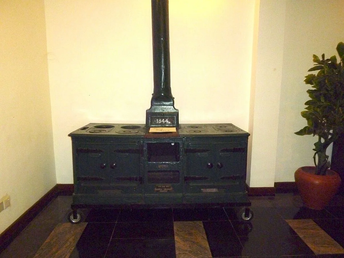
William Symington was an engineer for the Carron Company in the early 19th century, and the company made engines for his steamboats, The Experiment and The Charlotte Dundas. Henry Cort experimented on methods to produce malleable iron, anticipating the puddling process. Benjamin Franklin visited the factory, leaving works and is said to have left a design for a stove- 'Dr Franklin's stove or the Philadelphia stove'.

2013: An Iron Oven manufactured by Carron Company Scotland. Photo by MediaJet, the copyright holder of this work, and published under the (CC BY-SA 3.0) Creative Commons Attribution-Share Alike 3.0 Unported license. https://commons.wikimedia.org/wik…

2013: An Iron Oven manufactured by Carron Company Scotland. Photo by MediaJet, the copyright holder of this work, and published under the (CC BY-SA 3.0) Creative Commons Attribution-Share Alike 3.0 Unported license. https://commons.wikimedia.org/wiki/File:Carron_Iron_Oven-1844.JPG

The company produced pig iron throughout the 19th century, together with cast-iron products such as balustrades, fire grates, and the Carron bathtub. https://en.wikipedia.org/wiki/Carron_Company

Linlithgow: The main attraction is the remains of the Palace, below, but a second attraction, standing adjacent, is the 15th century St. Michael's Church.

1824: The Town of Linlithgow, from Clark's Views in Scotland. Artist & Engraver John Heaviside Clark, Publisher Smith & Elder, Fenchurch St, London. http://www.rareoldprints.com/z/16051

1824: The Town of Linlithgow, from Clark's Views in Scotland. Artist & Engraver John Heaviside Clark, Publisher Smith & Elder, Fenchurch St, London. http://www.rareoldprints.com/z/16051

Historic buildings of Linlithgow . The burgh's main historic buildings seen from the towpath of the Union Canal above Back Station Road: (l. to r.) the square tower of the 17thC Town Hall, St. Michael's Church with the distinctive modern replacement…

Historic buildings of Linlithgow . The burgh's main historic buildings seen from the towpath of the Union Canal above Back Station Road: (l. to r.) the square tower of the 17thC Town Hall, St. Michael's Church with the distinctive modern replacement for its original crown spire, and just beyond extending to the right of the kirk, the Royal Palace. © Copyright kim traynor and licensed for reuse under the (CC BY-SA 2.0) Creative Commons Licence. https://www.geograph.org.uk/photo/2741540

Many historic buildings line the High Street. On the road to the palace is the Cross Well of 1807 (redesigned by James Haldane) which proclaims itself to be a replica of its 1628 predecessor.

Cross Well, Linlithgow. The impressive structure was built in 1807 in front of the, currently under repair, Town House. © Copyright James Denham and licensed for reuse under the (CC BY-SA 2.0) Creative Commons Licence. https://www.geograph.org.uk/ph…

Cross Well, Linlithgow. The impressive structure was built in 1807 in front of the, currently under repair, Town House. © Copyright James Denham and licensed for reuse under the (CC BY-SA 2.0) Creative Commons Licence. https://www.geograph.org.uk/photo/1214440

To its north stands the Town House of 1668 by the master mason John Smith. This replaced a previous hall demolished by Oliver Cromwell's army in 1650. https://en.wikipedia.org/wiki/Linlithgow

Linlithgow Palace, probably Scotland's finest surviving late medieval secular building, was the birthplace of Mary, Queen of Scots, in December 1542. Lucy is wrong - Charles 1st was not born here - he only visited once, for a night, in 1633, although James V, Mary’s father, was born here on 10 April 1512. Mary occasionally stayed at the Palace during her reign. After the Union of the Crowns in 1603 the Royal Court became largely based in England and Linlithgow was used very little. The only reigning monarch to stay at Linlithgow after that date was King Charles I, who spent a night there in 1633.

Linlithgow Palace, Old undated watercolour. http://www.rareoldprints.com/z/15805

Linlithgow Palace, Old undated watercolour. http://www.rareoldprints.com/z/15805

To the Right Honble James Cart of Hopetow &c &c This South West View of the Palace of Linlithgow is with the with the most respect and deference inscribed by his Lordship's very obedient servants Jukes & Sarjent . http://www.rareoldprint…

To the Right Honble James Cart of Hopetow &c &c This South West View of the Palace of Linlithgow is with the with the most respect and deference inscribed by his Lordship's very obedient servants Jukes & Sarjent . http://www.rareoldprints.com/z/2760

An English visitor in October 1641 recorded in a poem that the roof of the great hall was already gone, the fountain vandalised by those who objected on religious grounds to the motto "God Save the King," but some woodcarving remained in the Chapel Royal. The palace's swansong came in September 1745, when Bonnie Prince Charlie visited Linlithgow on his march south but did not stay overnight. It is said that the fountain was made to flow with wine in his honour.

2005: Linlithgow Palace viewed from the east. Photo taken by AlistairMcMillan. This file is licensed under the (CC BY-SA 3.0) Creative Commons Attribution-Share Alike 3.0 Unported license. https://commons.wikimedia.org/wiki/File:Am_linlithgow_palace…

2005: Linlithgow Palace viewed from the east. Photo taken by AlistairMcMillan. This file is licensed under the (CC BY-SA 3.0) Creative Commons Attribution-Share Alike 3.0 Unported license. https://commons.wikimedia.org/wiki/File:Am_linlithgow_palace_east.jpg

The Duke of Cumberland's army destroyed most of the palace buildings by burning in January 1746. https://en.wikipedia.org/wiki/Linlithgow_Palace

St Michael’s church was consecrated in 1242. Following a fire in 1424, most of the present building dates from the mid-15th century. It was much favoured as a place of worship by Scottish Kings and Queens. Mary, Queen of Scots, was baptised in St Michael’s Church. In 1559, at an early stage of the Scottish Reformation, the Protestant Lords of the Congregation destroyed the statues adorning the exterior and interior of the church as signs of "popishness", and defaced the statue of St Michael which formed part of the structure. Following the Reformation, the interior of the church was reordered. Some traces of pre-Reformation artefacts can still be detected.

circa 1860: Linlithgow Church. Lithograph drawn and lithographed by James Gordon. Junr.. Published by A. & J. Macpherson, Edinburgh. https://antique-prints-maps.com/acatalog/ref1.php?imagefile=../largeimages/SELinlithgowChurch11.jpg

circa 1860: Linlithgow Church. Lithograph drawn and lithographed by James Gordon. Junr.. Published by A. & J. Macpherson, Edinburgh. https://antique-prints-maps.com/acatalog/ref1.php?imagefile=../largeimages/SELinlithgowChurch11.jpg

1847: Linlithgow Church. Interior looking West. Engraving by J.H. Le Keux after R.W. Billings. Published by William Blackwood & Sons, Edinburgh. https://www.antique-prints-maps.com/cgi-bin/sh000001.pl?WD=linlithgow&PN=Edinburgh_antique_print…

1847: Linlithgow Church. Interior looking West. Engraving by J.H. Le Keux after R.W. Billings. Published by William Blackwood & Sons, Edinburgh. https://www.antique-prints-maps.com/cgi-bin/sh000001.pl?WD=linlithgow&PN=Edinburgh_antique_prints%2ehtml#a2354274

In 1646, Oliver Cromwell's troops stabled their horses within the nave. Following the departure of the troops, considerable restoration was required. By the early 19th century the church was in a very poor physical condition. Although repairs were made, many of the historic features of the church were destroyed, the interior walls were whitewashed, a plaster ceiling replaced a fine 16th-century one and in 1821 the stone Crown Tower had to be dismantled. https://en.wikipedia.org/wiki/St_Michael%27s_Parish_Church,_Linlithgow St. Michael's western tower originally had a distinctive stone crown spire, but it was removed in the early 19th century. In 1964 a replacement and controversial spire in aluminium in a modern style by Scots architect Sir Basil Spence, representing Christ's crown of thorns, was added. (See photograph, below)

Tower of St Michael's, Linlithgow from the adjoining Linlithgow Palace. © Copyright Mike Pennington and licensed for reuse under the (CC BY-SA 2.0) Creative Commons Licence. https://www.geograph.org.uk/photo/1429743

Tower of St Michael's, Linlithgow from the adjoining Linlithgow Palace. © Copyright Mike Pennington and licensed for reuse under the (CC BY-SA 2.0) Creative Commons Licence. https://www.geograph.org.uk/photo/1429743

Battle of Flodden: It was James VI, not James V, who fought at the Battle of Flodden, or Flodden Field, a battle between the Kingdoms of England and Scotland resulting in an English victory. In keeping with his understanding of the medieval code of chivalry, King James IV sent notice to the English, one month in advance, of his intent to invade. This gave the English time to gather an army and to retrieve the banner of Saint Cuthbert from Durham Cathedral, a banner which had been carried by the English in victories against the Scots in 1138 and 1346. The battle was fought in Branxton, Northumberland on 9 September 1513, between an invading Scots army under King James IV and an English army commanded by the Earl of Surrey.

2005: The site of the Battle of Flodden Field. This image shows only the western side of the battlefield. The Scottish army advanced down the hill which in this image is ploughed (in the direction of the camera). The English advanced down the grassy…

2005: The site of the Battle of Flodden Field. This image shows only the western side of the battlefield. The Scottish army advanced down the hill which in this image is ploughed (in the direction of the camera). The English advanced down the grassy field away from the camera. The boundary between the ploughed field and the grassed field in the foreground forms a valley between the two fields. Photo by Tagishsimon, the copyright holder of this work, and published it under the (CC BY-SA 3.0) Creative Commons Attribution-Share Alike 3.0 Unported license.https://commons.wikimedia.org/wiki/File:Flodden_Field_(Braxton)_-_2004-Feb-06_-_Looking_SSE_from_the_monument.jpg

In terms of troop numbers, it was the largest battle fought between the two kingdoms. James IV was killed in the battle, becoming the last monarch from the British Isles to die in battle. https://en.wikipedia.org/wiki/Battle_of_Flodden

Edinburgh has been recognised as the capital of Scotland since at least the 15th century and is the seat of the Scottish Government, the Scottish Parliament and the supreme courts of Scotland.

1670: "The Citie of Edinburgh from the South" (detail) by Wenceslas Hollar. Some artistic licence has been used. For example, no tenements are visible on the north side of the High Street where the slope descends steeply to the Nor Loch. Heriot's Ho…

1670: "The Citie of Edinburgh from the South" (detail) by Wenceslas Hollar. Some artistic licence has been used. For example, no tenements are visible on the north side of the High Street where the slope descends steeply to the Nor Loch. Heriot's Hospital stands east (rather than west) of Potterow Port. This work is in the public domain in its country of origin and other countries and areas where the copyright term is the author's life plus 100 years or fewer. https://commons.wikimedia.org/wiki/File:Edinburgh_in_the_17thC_(detail)_by_Wenceslas_Hollar_(1670).jpg

The city's Palace of Holyrood house is the official residence of the monarch in Scotland. The city has long been a centre of education, particularly in the fields of medicine, Scots law, literature, philosophy, the sciences and engineering. It is the second largest financial centre in the United Kingdom after London and the city's historical and cultural attractions have made it the United Kingdom's second most popular tourist destination after London), attracting over one million overseas visitors each year. In the 17th century, Edinburgh's boundaries were still defined by the city's defensive town walls. As a result, the city's growing population was accommodated by increasing the height of the houses.

1822: Edinburgh. From Bridewell, on the Calton - Hill. Artist and Engraver T M Baynes, Publisher D. Walther Brydges St Covent Garden http://www.rareoldprints.com/p/18620

1822: Edinburgh. From Bridewell, on the Calton - Hill. Artist and Engraver T M Baynes, Publisher D. Walther Brydges St Covent Garden http://www.rareoldprints.com/p/18620

Buildings of 11 storeys or more were common and have been described as forerunners of the modern-day skyscraper. Following the Treaty of Union in 1706, the Parliaments of England and Scotland passed Acts of Union in 1706 and 1707 respectively, uniting the two kingdoms in the Kingdom of Great Britain effective from 1 May 1707. The Union was opposed by many Scots, resulting in riots in the city. By the first half of the 18th century, despite rising prosperity evidenced by its growing importance as a banking centre, Edinburgh was described as one of Europe's most densely populated, overcrowded and unsanitary towns. Visitors were struck by the fact that the various social classes shared the same urban space, even inhabiting the same tenement buildings; although here a form of social segregation did prevail, whereby shopkeepers and tradesmen tended to occupy the cheaper-to-rent cellars and garrets, while the more well-to-do professional classes occupied the more expensive middle storeys.

Arthur's Seat from Edinburgh Castle. "This City is the seat of the King of Scotland, and the Courts of Justice are held in the same. This City is high seated, in a fruitful soyle, and wholesome aire, and is adorned with many noblemen's Towers laying…

Arthur's Seat from Edinburgh Castle. "This City is the seat of the King of Scotland, and the Courts of Justice are held in the same. This City is high seated, in a fruitful soyle, and wholesome aire, and is adorned with many noblemen's Towers laying about it, and aboundeth with many springs of sweet waters. At the end towards the East, is the King's Pallace joyning to the Monastery of the Holy Crosse, which King David the first built, over which, in a Parke of Hares, Conies, and Deare, an high mountain hangs, called the chaire of Arthur." -- Fynes Moryson, An Itinerary, 1617. © Copyright kim traynor and licensed for reuse under the (CC BY-SA 2.0) Creative Commons Licence. https://www.geograph.org.uk/photo/2718968

The Town Council, keen to emulate London by initiating city improvements and expansion to the north of the castle, reaffirmed its belief in the Union and loyalty to the Hanoverian monarch George III by its choice of names for the streets of the New Town: for example, Rose Street and Thistle Street; and for the royal family, George Street, Queen Street, Hanover Street, Frederick Street and Princes Street (in honour of George's two sons. In the second half of the century, the city was at the heart of the Scottish Enlightenment, when thinkers like David Hume, Adam Smith, James Hutton and Joseph Black were familiar figures in its streets. Edinburgh became a major intellectual centre, earning it the nickname "Athens of the North" because of its many neo-classical buildings and reputation for learning, recalling ancient Athens. From the 1770s onwards, the professional and business classes gradually deserted the Old Town in favour of the more elegant "one-family" residences of the New Town, a migration that changed the city's social character. According to the foremost historian of this development, "Unity of social feeling was one of the most valuable heritages of old Edinburgh, and its disappearance was widely and properly lamented.". Although Edinburgh's traditional industries of printing, brewing and distilling continued to grow in the 19th century and were joined by new rubber works and engineering works, there was little industrialisation compared with other cities in Britain. By 1821, Edinburgh had been overtaken by Glasgow as Scotland's largest city. https://en.wikipedia.org/wiki/Edinburgh

2010: The most beautiful panorama of Edinburgh, seen from the Scott Monument by Oliver-Bonjoch, the copyright holder of this work, and published under the (CC BY-SA 3.0) Creative Commons Attribution-Share Alike 3.0 Unported license. https://commons.…

2010: The most beautiful panorama of Edinburgh, seen from the Scott Monument by Oliver-Bonjoch, the copyright holder of this work, and published under the (CC BY-SA 3.0) Creative Commons Attribution-Share Alike 3.0 Unported license. https://commons.wikimedia.org/wiki/File:Edinburgh_from_Scott_Monument.jpg

Description of the city in 1617: "This City is the seat of the King of Scotland, and the Courts of Justice are held in the same. This City is high seated, in a fruitful soyle, and wholesome aire, and is adorned with many noblemen's Towers laying about it, and aboundeth with many springs of sweet waters. At the end towards the East, is the King's Pallace joyning to the Monastery of the Holy Crosse, which King David the first built, over which, in a Parke of Hares, Conies, and Deare, an high mountain hangs, called the chaire of Arthur." -- Fynes Moryson, An Itinerary, 1617, sourced from https://www.geograph.org.uk/photo/2718968

Edinburgh Castle dominates the skyline of the city from its position on the Castle Rock. Research undertaken in 2014 identified 26 sieges in its 1100-year-old history, giving it a claim to having been "the most besieged place in Great Britain and one of the most attacked in the world". Few of the present buildings pre-date the Lang Siege of the 16th century, when the medieval defences were largely destroyed by artillery bombardment. The most notable exceptions are St Margaret's Chapel from the early 12th century, which is regarded as the oldest building in Edinburgh, the Royal Palace and the early-16th-century Great Hall, although the interiors have been much altered from the mid-Victorian period onwards.

circa 1760: Vue du Chateau d'Edimbourg, vue d'optique, Published by Basset. Paris. http://www.rareoldprints.com/p/5213

circa 1760: Vue du Chateau d'Edimbourg, vue d'optique, Published by Basset. Paris. http://www.rareoldprints.com/p/5213

circa 1800: Edinburgh Castle, in Midlothian, Engraving by Barclay published by Alexander Hogg. https://antique-prints-maps.com/acatalog/ref1.php?imagefile=../largeimages/SEEdinburghCastleHogg14.jpg

circa 1800: Edinburgh Castle, in Midlothian, Engraving by Barclay published by Alexander Hogg. https://antique-prints-maps.com/acatalog/ref1.php?imagefile=../largeimages/SEEdinburghCastleHogg14.jpg

During the 18th century the castle vaults were used to hold prisoners of war during several conflicts, including the Seven Years' War (1756–1763), the American War of Independence (1775–1783) and the Napoleonic Wars (1803–1815). During this time, several new buildings were erected within the castle, including powder magazines, stores, the Governor's House (1742), and the New Barracks (1796–1799). A mass prison break in 1811, in which 49 prisoners of war escaped via a hole in the south wall, persuaded the authorities that the castle vaults were no longer suitable as a prison. This use ceased in 1814 and the castle began gradually to assume a different role as a national monument.

1822: Visit of King George IV to Scotland, 1822, by James Skene (1775–1864) . Source scan from The King's Jaunt, John Prebble, Birlinn Limited, Edinburgh 2000, ISBN 1-84158-068-6 . Public domain. https://commons.wikimedia.org/wiki/File:KGIV_and_hat.…

1822: Visit of King George IV to Scotland, 1822, by James Skene (1775–1864) . Source scan from The King's Jaunt, John Prebble, Birlinn Limited, Edinburgh 2000, ISBN 1-84158-068-6 . Public domain. https://commons.wikimedia.org/wiki/File:KGIV_and_hat.jpg

In 1818, Sir Walter Scott was given permission to search the castle for the Crown of Scotland, believed lost after the union of Scotland and England in 1707. Breaking into a sealed room, now known as the Crown Room, and unlocking a chest within, he rediscovered the Honours of Scotland, which were then put on public display with an entry charge of one shilling. https://en.wikipedia.org/wiki/Edinburgh_Castle

2012: Edinburgh Castle seen from the roof of the National Museum of Scotland. The medieval burgh grew along the ridge sloping down from the castle, by Kim Traynor, the copyright holder of this work, and published under the (CC BY-SA 3.0) Creative Co…

2012: Edinburgh Castle seen from the roof of the National Museum of Scotland. The medieval burgh grew along the ridge sloping down from the castle, by Kim Traynor, the copyright holder of this work, and published under the (CC BY-SA 3.0) Creative Commons Attribution-Share Alike 3.0 Unported license. https://commons.wikimedia.org/wiki/File:Edinburgh_Castle_from_the_south_east.JPG

Princes Street lies on the line of a medieval country lane known as the Lang Gait and bounded by the Lang Dyke. In the original New Town plan Princes Street was to have been called St Giles Street, after the patron saint of Edinburgh, but King George III rejected the name, St Giles being also the patron saint of lepers and the name of a notorious 'rookery' of slums in London. The street is named after King George's two eldest sons, the Prince George, Duke of Rothesay (later King George IV) and the Prince Frederick, Duke of York and Albany. It was laid out according to formal plans for Edinburgh's New Town, now known as the First New Town. These were devised by the architect James Craig and building began around 1770.

Princes Street 1825 by Alexander Nasmyth, copied by Stephencdickson, the copyright holder of this work, and published under the (CC BY-SA 4.0) Creative Commons Attribution-Share Alike 4.0 International license. https://commons.wikimedia.org/wiki/Fil…

Princes Street 1825 by Alexander Nasmyth, copied by Stephencdickson, the copyright holder of this work, and published under the (CC BY-SA 4.0) Creative Commons Attribution-Share Alike 4.0 International license. https://commons.wikimedia.org/wiki/File:Princes_Street_1825_by_Alexander_Nasmyth.JPG

Princes Street represented a critical part of the plan, being the outer edge, facing Edinburgh Castle and the original city: "Edinburgh Old Town". Through the 19th century most buildings were redeveloped at a larger scale and the street evolved from residential to mainly retail uses. https://en.wikipedia.org/wiki/Princes_Street

2008: New Town, Edinburgh, looking west along Princes Street from Calton Hill, by Tharnton345. This work has been released into the public domain by its author, Tharnton345 at English Wikipedia. https://commons.wikimedia.org/wiki/File:New_Town,_Edin…

2008: New Town, Edinburgh, looking west along Princes Street from Calton Hill, by Tharnton345. This work has been released into the public domain by its author, Tharnton345 at English Wikipedia. https://commons.wikimedia.org/wiki/File:New_Town,_Edinburgh,_Panorama.jpg

London Hotel on St Andrews Square not found

St Andrews Square is located at the east end of George Street. The construction of St Andrew Square began in 1772, as the first part of the New Town, designed by James Craig. Within six years of its completion St Andrew Square became one of the most desirable and most fashionable residential areas in the city.

1829: East Side of St Andrew's Square, Edinburgh by Thomas Hosmer Shepherd. Image extracted from page 29 of Modern Athens, displayed in a series of views; or, Edinburgh in the nineteenth century; exhibiting the whole of the new buildings, modern imp…

1829: East Side of St Andrew's Square, Edinburgh by Thomas Hosmer Shepherd. Image extracted from page 29 of Modern Athens, displayed in a series of views; or, Edinburgh in the nineteenth century; exhibiting the whole of the new buildings, modern improvements, antiquities, & picturesque scenery of the Scottish metropolis & its environs, by Thomas Hosmer Shepherd (original drawings) with John Britton (text). Original held and digitised by the British Library, Accession number HMNTS 010370.dd.10. https://commons.wikimedia.org/wiki/File:MA(1829)_p.029_-_East_Side_of_St_Andrew%27s_Square,_Edinburgh_-_Thomas_Hosmer_Shepherd.jpg

As the 19th century ended, St Andrew Square evolved into the commercial centre of the city and most of the square evolved into the major offices of banks and insurance companies, making it one of the major financial centres in Scotland. https://en.wikipedia.org/wiki/St_Andrew_Square,_Edinburgh Lucy’s London Hotel would probably have been moved as the area became more commercial. She would not have seen the centrepiece of the square, Lord Melville's monument, which was erected four years later, in 1823

2019: View of the Melville Monument in the centre of St Andrew’s Square by the author. Lucy would not have seen the monument - it was erected four years later in 1823

2019: View of the Melville Monument in the centre of St Andrew’s Square by the author. Lucy would not have seen the monument - it was erected four years later in 1823

Music Festival: Edinburgh enjoyed its first ‘Musical Festival Week’ on 30 October 1815: “From England, and the remotest parts of Scotland, individuals and whole families poured into the city. Every house and every room that could be obtained was occupied by persons of all ranks and ages…” (G. F. Graham, 1816 in his Account of the first Edinburgh Musical Festival). Concerts sold out very quickly and directors immediately arranged an extra performance. The first piece of music played in the festival was the overture to Handel’s oratorio Esther.

The overture to Handel’s Esther published by John Walsh in 1732, the first piece of music played in the festival https://blog.nls.uk/wordpress/wp-content/uploads/2015/10/BH112EstherOvertureP1LowRes-115388946.jpg

The overture to Handel’s Esther published by John Walsh in 1732, the first piece of music played in the festival https://blog.nls.uk/wordpress/wp-content/uploads/2015/10/BH112EstherOvertureP1LowRes-115388946.jpg

https://www.researchgate.net/publication/304538157_'The_First_Edinburgh_Musical_Festival_'serious_and_magnificent_entertainment'_or_'a_combination_of_harmonious_and_discordant_notes' https://blog.nls.uk/the-first-edinburgh-musical-festival-of-1815/

THE SECOND EDINBURGH MUSIC FESTVAL WAS HELD DURING LUCY’S VISIT, with the Theatre Royal taking over from Corri’s Rooms. There have been a number of Theatre Royals – this is the first one that was situated at the east end of Princes Street. This festival produced a profit of £1,231 that was again distributed to charities. https://bkthisandthat.org.uk/a-history-of-the-edinburgh-festivals/ The theatre was adapted inside to accommodate a larger audience 1819. Page 28, John Leonard Cranmer’s Thesis CONCERT LIFE AND THE MUSIC TRADE IN EDINBURGH c.1780-c.1830 https://www.era.lib.ed.ac.uk/bitstream/1842/7380/2/Cranmer1991_redact.pdf

Can you help us?

Transcription problems: As untrained transcribers we sometimes experience problems interpreting some of Lucy’s writing. We have a problem deciphering one section today:

LUCY 151b-extract.jpg

…foretold the miseries which ?over-? bring? her and Scotland ?1st? came? said (speaking of the crown) with .. We feel we should really have solved this one and want to write “foretold the miseries which overcame her and Scotland, it can be said (speaking of the crown) with ‘Alas, it will be lost with one!’ but the words we have suggested just do not fit what Lucy appears to have written

Old Regency Prints, Pictures an Coaching maps: Do you have access to any prints or pictures showing what town and country would have looked like when Lucy travelled through? Any illustrations of what she would have seen in 1819 will enliven our research.

New Pictures: Do you have any modern pictures of the streets, buildings, gardens and views that would enable us to see the changes that two centuries have wrought?

12th October 1819, Brackland Bridge, Carriages to Doune, Doune Castle, Stirling, Garrison, Gibbs Hotel

Tuesday 12th October 1819

 
LUCY 150b.jpg
 
LUCY 151a.jpg
 

Tuesday Oct 12th At 8 o’clock we took a guide & walked over a wet & most wretched footpath to the ?*** ***? bridge of Brackland where there is a fine waterfall the situation is very fine & the lochs of a square shape & very striking after 2 more miles walk we reached the road where our carriages were waiting & proceeded to Doune 8 miles from Callander to breakfast after breakfast we visited Doune Castle a very fine ruin commanding a beautiful view several of the rooms & staircases are entire we then continued our journey to Stirling five miles we drove to Gibbs Hotel which is excellent before dinner we walked to the garrison built on very high steep rocks somewhat resembling the basaltic pillars part of the old Castle remains which is curiously ??crenelated?? on the outside

the view from it is very extensive & the winding of the river forth which can be discerned for miles very beautiful the town of Stirling is very dirty & irregularly built & I cannot say I have the least wish to remain here longer than tomorrow morning.


OBSERVATIONS & COMMENTS:

Bridge of Brackland: Visited by Queen Victoria, the Bracklinn Falls are one of the most spectacular waterfalls in Scotland, north-east of Callander on the course of the Keltie Wate.

2002: Bracklinn Falls by Sarah Charlesworth. This image was taken from the Geograph project collection. The copyright on this image is owned by Sarah Charlesworth and is licensed for reuse under the (CC BY-SA 2.0) Creative Commons Attribution-Share …

2002: Bracklinn Falls by Sarah Charlesworth. This image was taken from the Geograph project collection. The copyright on this image is owned by Sarah Charlesworth and is licensed for reuse under the (CC BY-SA 2.0) Creative Commons Attribution-Share Alike 2.0 Generic license. https://commons.wikimedia.org/wiki/File:Bracklinn_Falls_-_geograph.org.uk_-_921667.jpg

In 2004, a long-standing steel footbridge over the falls was washed away by severe floods and, in October 2010, a new wood-and-copper footbridge was hauled into place by hand because the location made it impossible to use a crane. The falls were seen in the 1975 comedy film, Monty Python and the Holy Grail. It is not certain what type of bridge was present in 1819. https://en.wikipedia.org/wiki/Bracklinn_Falls

Doune is well known for pistols and Roman remains, and allegedly a Doune pistol fired the first shot of the American War of Independence. The town is dominated by Doune Castle, built in the late 14th century. Architecturally it is a mixture of fortress and manor house. Bonnie Prince Charlie passed through Doune in 1745.

Main Street, Doune . This is the main road through the village. © Copyright Colin Smith and licensed for reuse under the (CC BY-SA 2.0) Creative Commons Licence. https://www.geograph.org.uk/photo/219190

Main Street, Doune . This is the main road through the village. © Copyright Colin Smith and licensed for reuse under the (CC BY-SA 2.0) Creative Commons Licence. https://www.geograph.org.uk/photo/219190

Like in other Celtic lands, Doune also has tales of fairies. One such place is Ternishee, a small wood east of the Annat chapel, above Doune Lodge, 1½ miles from Doune. Its name comes from the Gaelic "tir na sídhe" meaning land of the fairy. Fairy dancing parties are recounted on the Fairy Knowe, a hillock on the right bank of the Ardoch, half a mile east of Doune. Also near the Bridge of Teith, on the low road to Callander, a burial mound called Tullochanknowe is said to be a favourite haunt of the fairies. https://en.wikipedia.org/wiki/Doune

Doune Castle was originally built in the thirteenth century, then probably damaged in the Scottish Wars of Independence, before being rebuilt in its present form in the late 14th century by Robert Stewart, Duke of Albany (c.1340–1420), the son of King Robert II of Scots. His stronghold has survived relatively unchanged and complete. The castle passed to the crown in 1425, when Albany's son was executed, and was used as a royal hunting lodge and dower house. In the later 16th century, Doune became the property of the Earls of Moray. The castle saw military action during the Wars of the Three Kingdoms and Glencairn's rising in the mid-17th century, and during the Jacobite risings of the late 17th century and 18th century.

1804: Scotia Depicta - Doune Castle Plate XL/b - John Claude Nattes made drawings of suitable scenes on the spot; etchings are by James Fittler. Collection of the National Library of Scotland Accession number 74582402. This work is in the public dom…

1804: Scotia Depicta - Doune Castle Plate XL/b - John Claude Nattes made drawings of suitable scenes on the spot; etchings are by James Fittler. Collection of the National Library of Scotland Accession number 74582402. This work is in the public domain in its country of origin and other countries and areas where the copyright term is the author's life plus 100 years or fewer. https://commons.wikimedia.org/wiki/File:Scotia_Depicta_-_Doune_Castle_-Plate-.jpg

By 1800 the castle was ruined, but restoration works were carried out in the 1880s, prior to its passing into state care in the 20th century. https://en.wikipedia.org/wiki/Doune_Castle

2016: Aerial view of Doune Castle and Castle keeper's cottage, Doune, Scotland , Author Godot13, Attribution Andrew Shiva / Wikipedia and published under the (CC BY-SA 4.0) Creative Commons Attribution-Share Alike 4.0 International license. https://…

2016: Aerial view of Doune Castle and Castle keeper's cottage, Doune, Scotland , Author Godot13, Attribution Andrew Shiva / Wikipedia and published under the (CC BY-SA 4.0) Creative Commons Attribution-Share Alike 4.0 International license. https://commons.wikimedia.org/wiki/File:Scotland-2016-Aerial-Doune_Castle_(and_Castle_keeper%27s_cottage).jpg

Doune Castle. From the English Wikipedia en:Image:Doune_Castle_south_wall.jpg. Original photograph by en:User:Deez. The copyright holder of this work allows anyone to use it for any purpose including unrestricted redistribution, commercial use, and …

Doune Castle. From the English Wikipedia en:Image:Doune_Castle_south_wall.jpg. Original photograph by en:User:Deez. The copyright holder of this work allows anyone to use it for any purpose including unrestricted redistribution, commercial use, and modification. https://commons.wikimedia.org/wiki/File:Doune_Castle_south_wall.jpg

2013: Doune Castle: Medieval stronghold near the village of Doune, in the Stirling district of central Scotland, view from Northeast by Wikifan75, the copyright holder of this work, and published under the (CC BY-SA 3.0) Creative Commons Attribution…

2013: Doune Castle: Medieval stronghold near the village of Doune, in the Stirling district of central Scotland, view from Northeast by Wikifan75, the copyright holder of this work, and published under the (CC BY-SA 3.0) Creative Commons Attribution-Share Alike 3.0 Unported license. https://commons.wikimedia.org/wiki/File:Doune_Castle_Scotland.jpg

Stirling, when under Anglo-Saxon sway, was attacked by Danish invaders. According to a 9th-century legend, the sound of a wolf roused a sentry, however, who alerted his garrison, which forced a Viking retreat. This led to the wolf being adopted as a symbol of the town and the area is today known as Wolfcraig. Once the capital of Scotland, Stirling is visually dominated by Stirling Castle.

2004: Stirling from Braehead by Peter Gordon. This image was taken from the Geograph project collection. The copyright on this image is owned by Peter Gordon and is licensed for reuse under the (CC BY-SA 2.0) Creative Commons Attribution-Share Alike…

2004: Stirling from Braehead by Peter Gordon. This image was taken from the Geograph project collection. The copyright on this image is owned by Peter Gordon and is licensed for reuse under the (CC BY-SA 2.0) Creative Commons Attribution-Share Alike 2.0 Generic license. https://commons.wikimedia.org/wiki/File:Stirling_from_Braehead_-_December_2004_-_geograph.org.uk_-_254316.jpg

The view from Stirling Castle , Looking over the Forth Valley to the Wallace Monument and the Ochil Hills. © Copyright Graham Hogg and licensed for reuse under the (CC BY-SA 2.0) Creative Commons Licence. https://www.geograph.org.uk/photo/5965401

The view from Stirling Castle , Looking over the Forth Valley to the Wallace Monument and the Ochil Hills. © Copyright Graham Hogg and licensed for reuse under the (CC BY-SA 2.0) Creative Commons Licence. https://www.geograph.org.uk/photo/5965401

Stirling also has a medieval parish church, the Church of the Holy Rude, where, on 29 July 1567, the infant James VI was anointed King of Scots by the Bishop of Orkney with the service concluding after a sermon by John Knox.

2010: Church of the Holy Rude, Stirling, Scotland. View from Stirling Castle by Postdlf and published under the (CC BY-SA 3.0) Creative Commons Attribution-Share Alike 3.0 Unported license. https://commons.wikimedia.org/wiki/File:Church_of_the_Holy_…

2010: Church of the Holy Rude, Stirling, Scotland. View from Stirling Castle by Postdlf and published under the (CC BY-SA 3.0) Creative Commons Attribution-Share Alike 3.0 Unported license. https://commons.wikimedia.org/wiki/File:Church_of_the_Holy_Rude_001.jpg

James VI was educated by George Buchanan and grew up in Stirling. He was later crowned King of England and Ireland on 25 July 1603, bringing closer the countries of the United Kingdom. The church, founded in 1129, is the second oldest building in the city after Stirling castle. It was rebuilt in the 15th century after Stirling suffered a catastrophic fire in 1405, and is reputed to be the only surviving church in the United Kingdom apart from Westminster Abbey to have held a coronation. Musket shot marks that may come from Cromwell's troops during the Wars of the Three Kingdoms are clearly visible on the tower and apse of the church. https://en.wikipedia.org/wiki/Stirling

Gibbs Hotel, initially known as Wingate’s Inn opened to much “fanfare and anticipation” in 1786 to “provide a valuable service to visitors and travellers to and from Stirling alike.” James Wingate, a Stirling business man, commissioned the famous Scottish architect Gideon Gray to build a hotel on the site of The Gibb’s Inn Tavern and Lodgings, located in Quality Street Stirling. The Gibb’s Inn was according to antiquity, “The principal hotel in Stirling catering for coaches going north to Perth – ‘The Difiance’ 4 horse coach leaving at 8.50am – and south to Glasgow – ‘The Rapide’ leaving for Glasgow at 8.30am, both from the pend behind the Inn.”

The Golden Lion, Stirling . Hotel in the centre of Stirling. Built by James Whingate and opened in May 1786. © Copyright Dan and licensed for reuse under the (CC BY-SA 2.0) Creative Commons Licence. https://www.geograph.org.uk/photo/1157331

The Golden Lion, Stirling . Hotel in the centre of Stirling. Built by James Whingate and opened in May 1786. © Copyright Dan and licensed for reuse under the (CC BY-SA 2.0) Creative Commons Licence. https://www.geograph.org.uk/photo/1157331

On the 26th August 1787 Robert Burns then aged 28 and his travelling companion Willie Nicol, who was a Master at Edinburgh High School, Latin scholar and student of literature visited Stirling Castle. They stayed at The Golden Lion and in the evening they were joined for dinner in the Hotel by local businessman Mr. Christopher Bell. At the time the Castle was in a very rundown condition and this inspired him to write the famous “Stirling Lines” and etched the following verse on a pane of glass in his second floor bedroom. “Here Stuarts once in glory reign’d, And laws for Scotland’s weal ordain’d ; But now unroof ‘d their palace stands, Their sceptre’s sway’d by other hands. The injur’d Stuart line is gone, A race outlandish fills their throne An idiot race, to honour lost : Who know them best despise them most.” Realising his lament for the deposed Stuart line and shock at the dilapidated state of The Castle had caused offence, Burns returned to the hotel in October of that year and smashed the pane of glass with the butt of his riding crop. James Macdonald the Hebridean diarist recorded in his journal of the 2nd June 1796 that he had enjoyed dinner with Burns the evening previous in Sanquhar Dumfrieshire where, Burns discussed at length his stay at the Golden Lion Hotel. This was only two months before Burns died at the age of 37.In 1820 the name Quality Street was changed to its present name of King Street in honour of King George IV, who ascended to the throne in that year. http://www.thegoldenlionstirling.com/the-hotel/heritage-history/

Stirling Castle was one of the most used of the many Scottish royal residences, before the Union, very much a palace as well as a fortress.

Stirling Castle . Artist: G B Campion Engraver: R Wallis. http://www.rareoldprints.com/z/5668

Stirling Castle . Artist: G B Campion Engraver: R Wallis. http://www.rareoldprints.com/z/5668

Stirling Castle. Artist & Engraver W Banks http://www.rareoldprints.com/z/16911

Stirling Castle. Artist & Engraver W Banks http://www.rareoldprints.com/z/16911

Considered the mightiest stronghold in the kingdom, Stirling Castle played a prominent part in the 13th and 14th century Wars of Independence against England. In 1296, it was occupied by King Edward I during his triumphant conquest of Scotland, but in the following year was retaken by the Scots after William Wallace's victory over an English force in the battle of Stirling Bridge. A second invasion culminated in the great siege of 1304 when Stirling was the last castle in Scotland to surrender to Edward. With an absentee king, the exiled John Balliol, and no hope of reinforcement, 140 men led by Sir William Oliphant stubbornly held out, claiming that they were holding the castle "for the Lion", i.e. the royal standard fluttering above its ramparts. But after a pounding from 13 siege engines over three months, the beleaguered garrison finally capitulated and its members were carted off to English prisons. Among the weapons employed by the English besiegers was a massive engine called the 'War Wolf'. Because it was as yet untried, Edward, keen to see its effect, insisted that some of the garrison return to the castle until it had been fired against the walls. A plaque on the wall of the King's Old Building in the Upper Square commemorates the garrison's heroic defence during the siege. Under King Robert the Bruce (r.1306-29) most Scottish castles were won back from English control until, by 1313, Stirling was one of only three still in enemy hands. Having besieged the castle for several months, Edward Bruce, much to his brother's annoyance, arranged with the castle governor that the defenders would surrender if an English army failed to come within three leagues of Stirling by the following Midsummer's Day, 1314. The result was the battle of Bannockburn in which Bruce's heavily outnumbered footsoldiers defeated an approaching army of English knights led by Edward II. After the battle the castle was returned to the Scots who partly dismantled the fortifications in line with Bruce's policy of denying the enemy future strongholds, "lest the English ever afterwards might lord it over the land by holding the castles". In 1337, during the second War of Independence (1332-56), Edward III's troops garrisoned the castle after Bruce's son and heir, David II (r.1329-71), had fled to France. In 1342 their five years long occupation ended after a siege lasting six months, during which, according to Froissart's Chronicles, cannon were used for the first time in Scotland. With the accession of Robert II (r.1371-90) the castle began its long association with the Stewart monarchs, many of whom were either born within its walls or spent their minorities there. https://www.geograph.org.uk/photo/2719623

Stirling Castle. © Copyright kim traynor and licensed for reuse under the (CC BY-SA 2.0) Creative Commons Licence. https://www.geograph.org.uk/photo/2719623

Stirling Castle. © Copyright kim traynor and licensed for reuse under the (CC BY-SA 2.0) Creative Commons Licence. https://www.geograph.org.uk/photo/2719623

Several Scottish Kings and Queens have been crowned at Stirling, including Mary, Queen of Scots, in 1542, and others were born or died there. The chronicler, William Worcester, associated Stirling with the court of the legendary King Arthur. After the Union the royal family left for London and Stirling's role as a royal residence declined, becoming principally a military centre. It was used as a prison for persons of rank during the 17th century and saw few visits by the monarch. Following the execution of Charles I, the Scots crowned his son Charles II, and he became the last reigning monarch to stay here, living at the castle in 1650. After the Restoration of Charles II the castle was frequently used as a prison, housing several Covenanters. During this time, the castle's military role became increasingly important, a powder magazine being built in the castle gardens, and a formal garrison installed from 1685.

Stirling Castle against evening light, looking up the main approach to the castle. © Copyright Bill Boaden and licensed for reuse under the (CC BY-SA 2.0) Creative Commons Licence. https://www.geograph.org.uk/photo/3605077

Stirling Castle against evening light, looking up the main approach to the castle. © Copyright Bill Boaden and licensed for reuse under the (CC BY-SA 2.0) Creative Commons Licence. https://www.geograph.org.uk/photo/3605077

From 1800 the Castle was owned by the War Office and run as a barracks. Many alterations were made to the Great Hall, which became an accommodation block, to the Chapel Royal, which became a lecture theatre and dining hall, to the King's Old Building, which became an infirmary and to the Royal Palace, which became the Officer's Mess. In 1810 new buildings were constructed, including the prison and powder magazine, at the Nether Bailey https://en.wikipedia.org/wiki/Stirling_Castle

Can you help us?

Transcription problems: As untrained transcribers we sometimes experience problems interpreting some of Lucy’s writing. We have a problem deciphering two sections today:

LUCY 150b-extract.jpg

over a wet & most wretched footpath to the ?*** ***? bridge of Brackland where there is We have been unable to interpret the first word of Lucy’s superscript.

LUCY 150b-extract-2.jpg

part of the old Castle remains which is curiously ??crenelated?? on the outside We’r okay with the word curiously above the deletion but cannot interpret the word that follows and have hazarded a guess with “crenelated”

Old Regency Prints, Pictures an Coaching maps: Do you have access to any prints or pictures showing what town and country would have looked like when Lucy travelled through? Any illustrations of what she would have seen in 1819 will enliven our research.

New Pictures: Do you have any modern pictures of the streets, buildings, gardens and views that would enable us to see the changes that two centuries have wrought?

11th October 1819, Loch Katrine carriage and row boat, Trossachs, Callander

Monday 11th October 1819

 
LUCY 149b.jpg
 
LUCY 150a.jpg
 

Monday Oct 11th At ½ past seven in the morning we started for Loch Katrine the Inn 10 miles off where we breakfasted is situated a mile & ½ from the lake the road to it is exceedingly bad but the country fine & mountainous; after breakfast the day which was very unfavourable became so much worse that the gentlemen thought it advisable for the ladies not to venture out but they returned & we all went to the east end of the loch in the carriage over a wretched road where we entered a boat with a very agreeable party whom we met there & rowed about 4 miles up the lake I cannot describe the beauty of this loch surrounded by the Trosachs rendered doubly interesting by being the subject of Walter Scotts poem the autumn tints also added greatly to the richness of the mountains which are covered with oak & the clouds

now & then dispersing & disclosing the tops of the most rugged mountains complement to render the scene truly enchanting the rain however which continued violently did not prevent us to enjoy it & about 3 o’clock we returned to Callander in the evening the party we met drank tea with us.


OBSERVATIONS & COMMENTS:

Loch Katrine is a freshwater loch and is a popular destination for tourists and day visitors from Glasgow and nearby towns. The loch derives its name from the term cateran from the Gaelic ceathairne, a collective word meaning cattle thief or possibly peasantry. Historically this referred to a band of fighting men of a clan; hence the term applied to marauders or cattle-lifters, which Rob Roy MacGregor, a respectable cattle owner was erroneously accused of being.

1810: Loch Katrine by Alexander Nasmyth, 1810 reproduced by Stephencdickson, the copyright holder of this work, and published it under the (CC BY-SA 4.0) Creative Commons Attribution-Share Alike 4.0 International license. https://commons.wikimedia.o…

1810: Loch Katrine by Alexander Nasmyth, 1810 reproduced by Stephencdickson, the copyright holder of this work, and published it under the (CC BY-SA 4.0) Creative Commons Attribution-Share Alike 4.0 International license. https://commons.wikimedia.org/wiki/File:Loch_Katrine_by_Alexander_Nasmyth,_1810.JPG

2000: Loch Katrine. Taken just above Stronachlachar, looking eastward the length of the loch which supplies Glasgow with drinking water. © Copyright Richard Webb and licensed for reuse under the (CC BY-SA 2.0) Creative Commons Licence. https://www.g…

2000: Loch Katrine. Taken just above Stronachlachar, looking eastward the length of the loch which supplies Glasgow with drinking water. © Copyright Richard Webb and licensed for reuse under the (CC BY-SA 2.0) Creative Commons Licence. https://www.geograph.org.uk/photo/29726

It is the fictional setting of Sir Walter Scott's poem The Lady of the Lake and of the subsequent opera by Gioachino Rossini, La donna del lago. https://en.wikipedia.org/wiki/Loch_Katrine & https://www.visitscotland.com/info/towns-villages/loch-katrine-p662921

Local Inns poor. In the first half of the 19th century, intrepid visitors to the area found conditions difficult. Thomas Carlyle visited a little inn near Loch Katrine in 1818 and found only 'bad oatcakes and unacceptable whisky' on the menu. EXCELLENT ARTICLE ON TOURISM HERE AND IN THE LAKES IN THE QUEST FOR “THE PICTURESQUE” http://www.lochlomondtrossachs.org.uk/tourist-era?showall=1&limitstart=

The Trossachs were one of the first parts of Scotland to become a recognised tourist destination due the area's position on the southern edge of the highlands and the quality of the scenery, which may be considered to represent a microcosm of a typical highland landscape.

2016:An overlook viewing an area of wooded land in the Trossachs and part of Loch Katrine by Hobbes The Great, the copyright holder of this work, and published under the (CC BY-SA 4.0) Creative Commons Attribution-ShareAlike 4.0 License. https://en.…

2016:An overlook viewing an area of wooded land in the Trossachs and part of Loch Katrine by Hobbes The Great, the copyright holder of this work, and published under the (CC BY-SA 4.0) Creative Commons Attribution-ShareAlike 4.0 License. https://en.wikipedia.org/wiki/File:Wooded_area_of_the_Trossachs_and_Loch_Katrine.jpg

2007: Ben Venue, seen rising above Achray Forest by Grinner, the copyright holder of this work, and published under the (CC BY-SA 3.0) Creative Commons Attribution-Share Alike 3.0 Unported license. https://commons.wikimedia.org/wiki/File:Ben_Venue.J…

2007: Ben Venue, seen rising above Achray Forest by Grinner, the copyright holder of this work, and published under the (CC BY-SA 3.0) Creative Commons Attribution-Share Alike 3.0 Unported license. https://commons.wikimedia.org/wiki/File:Ben_Venue.JPG

2005: a loch (probably Loch Chon) in the Trossachs, Scotland by David Monniaux and licensed under the (CC BY-SA 3.0) Creative Commons Attribution-Share Alike 3.0 Unported license. https://commons.wikimedia.org/wiki/File:Trossachs_loch_dsc06739.jpg

2005: a loch (probably Loch Chon) in the Trossachs, Scotland by David Monniaux and licensed under the (CC BY-SA 3.0) Creative Commons Attribution-Share Alike 3.0 Unported license. https://commons.wikimedia.org/wiki/File:Trossachs_loch_dsc06739.jpg

The poet William Wordsworth and his sister Dorothy visited the area, with Dorothy publishing an account of their visit in Recollections of a Tour Made in Scotland in 1803. The scenic charms of the area came to popularity with Sir Walter Scott's 1810 poem The Lady of the Lake, extending his romantic portrayal of Scotland's past from border ballads to poems of a medieval past rich in chivalry and symbolism. The poem gives a roll call of Trossachs place names, the lady herself being found on Loch Katrine. Scott followed up with his 1817 historical novel Rob Roy romanticising the outlaw cattle thief Raibert Ruadh, who was born by Loch Katrine and buried at nearby Balquhidder. https://en.wikipedia.org/wiki/Trossachs

The Lady of the Lake is a narrative poem by Sir Walter Scott, first published in 1810.

1822: Portrait of Sir Walter Scott by Henry Raeburn from the collection of the National Galleries of Scotland, Accession number PG 1286 and Purchased with assistance from the Art Fund 1935. Photographer The Bridgeman Art Library, Object 68272. https…

1822: Portrait of Sir Walter Scott by Henry Raeburn from the collection of the National Galleries of Scotland, Accession number PG 1286 and Purchased with assistance from the Art Fund 1935. Photographer The Bridgeman Art Library, Object 68272. https://commons.wikimedia.org/wiki/File:Sir_Henry_Raeburn_-_Portrait_of_Sir_Walter_Scott.jpg

Set in the Trossachs region of Scotland, it is composed of six cantos, each of which concerns the action of a single day. The poem has three main plots: the contest among three men, Roderick Dhu, James Fitz-James, and Malcolm Graeme, to win the love of Ellen Douglas; the feud and reconciliation of King James V of Scotland and James Douglas; and a war between the lowland Scots (led by James V) and the highland clans (led by Roderick Dhu of Clan Alpine).

1849: Illustration for The Lady of the Lake, poem by w:Walter Scott. Artist Alexander Johnston. Source/Photographer Art UK. This work is in the public domain in its country of origin and other countries and areas where the copyright term is the auth…

1849: Illustration for The Lady of the Lake, poem by w:Walter Scott. Artist Alexander Johnston. Source/Photographer Art UK. This work is in the public domain in its country of origin and other countries and areas where the copyright term is the author's life plus 70 years or fewer. https://commons.wikimedia.org/wiki/File:Lady_of_the_Lake_Johnston.jpg

The poem was tremendously influential in the nineteenth century and inspired the Highland Revival. https://en.wikipedia.org/wiki/The_Lady_of_the_Lake_(poem)

Can you help us?

Old Regency Prints, Pictures an Coaching maps: Do you have access to any prints or pictures showing what town and country would have looked like when Lucy travelled through? Any illustrations of what she would have seen in 1819 will enliven our research.

New Pictures: Do you have any modern pictures of the streets, buildings, gardens and views that would enable us to see the changes that two centuries have wrought?

10th October 1819, Lochearnhead, Loch Lubnaig, Callander

Sunday 10th October 1819

 
LUCY 148b.jpg
 
LUCY 149a.jpg
 

Sunday Oct 10th At 12 o’clock we left Killin & passing 8 miles of a most wild & mountainous country arrived at Lochearnhead situated at the top of Lochearn a fine lake having rested the horses we proceeded to Callander 16 miles the road is very bad, but

the country excessively fine in our way we passed Loch Lubnaig surrounded by most rugged & stupendous mountains the rain which has continued violently since yesterday made cataracts & rocks views enormously fine. The Inn at Callander is very good.


OBSERVATIONS & COMMENTS:

Lochearnhead lies at the foot of Glen Ogle and is situated at the western end of Loch Earn, with the settlement running from its shores up to higher ground on the hills at the mouth of Glen Ogle.

2007: Lochearnhead and Glen Ogle by Gartnait at English Wikipedia and released into the public domain by its author. https://commons.wikimedia.org/wiki/File:Lochearnhead_and_Glen_Ogle.JPG

2007: Lochearnhead and Glen Ogle by Gartnait at English Wikipedia and released into the public domain by its author. https://commons.wikimedia.org/wiki/File:Lochearnhead_and_Glen_Ogle.JPG

It lies within the Breadalbane area of the Loch Lomond and The Trossachs National Park.Numerous tales of hauntings and legends are associated with the place that make fun reading (wikipedia link, below, from which this information and image have been extracted) https://en.wikipedia.org/wiki/Lochearnhead

Loch Earn is long and narrow but is unusual in that it has its own apparent 'tidal system', or seiche, caused by the action of the prevailing wind blowing along the loch.

2007: View from Loch Earn sailing club towards St. Fillans in the early hours of the morning by Inafinus, the copyright holder of this work, and published under the Creative Commons (CC BY-SA 3.0) Attribution-Share Alike 3.0 Unported license. https:…

2007: View from Loch Earn sailing club towards St. Fillans in the early hours of the morning by Inafinus, the copyright holder of this work, and published under the Creative Commons (CC BY-SA 3.0) Attribution-Share Alike 3.0 Unported license. https://commons.wikimedia.org/wiki/File:St_Fillans_from_Loch_Earn_Sailing_Club.jpg

This wind pressure on the surface causes the water level to build up at one end of the loch and the water will return to the opposite end of the loch over time, in the case of Loch Earn over 16 hours. https://en.wikipedia.org/wiki/Loch_Earn

Callander serves as the eastern gateway to the Loch Lomond and the Trossachs National Park, the first National Park in Scotland, and is often referred to as the "Gateway to the Highlands".

2006: Bridgend from Callander Crags by Colin Smith. Lying south of the bridge, this is the oldest part of Callander. The long and narrow burgage plots are seen running away at right angles from the street. The newer, planned gridiron, part of the vi…

2006: Bridgend from Callander Crags by Colin Smith. Lying south of the bridge, this is the oldest part of Callander. The long and narrow burgage plots are seen running away at right angles from the street. The newer, planned gridiron, part of the village is north of the river ie bottom edge of the photograph. Also visible at this edge is the small hill, Tom na Kessog, which may have been built as a Norman motte. This image was taken from the Geograph project collection. The copyright on this image is owned by Colin Smith and is licensed for reuse under the (CC BY-SA 2.0) Creative Commons Attribution-ShareAlike 2.0 license. https://commons.wikimedia.org/wiki/File:Bridgend_from_Callander_Crags_-_geograph.org.uk_-_222369.jpg

A 19th century Gothic church stands in the town square, named after Saint Kessog, an Irish missionary who is said to have preached in the area in the sixth-century.

2006: Church at Callander Used as a tourist office now by Kenneth Allen. This image was taken from the Geograph project collection. The copyright on this image is owned by Kenneth Allen and is licensed for reuse under the (CC BY-SA 2.0) Creative Com…

2006: Church at Callander Used as a tourist office now by Kenneth Allen. This image was taken from the Geograph project collection. The copyright on this image is owned by Kenneth Allen and is licensed for reuse under the (CC BY-SA 2.0) Creative Commons Attribution-ShareAlike 2.0 license. https://commons.wikimedia.org/wiki/File:Church_at_Callander_-_geograph.org.uk_-_250407.jpg

The church closed in 1985 but became home to a visitor centre and audio-visual attraction telling the story of local outlaw, Rob Roy MacGregor. https://en.wikipedia.org/wiki/Callander

Loch Lubnaig is a small freshwater loch near Callander

2004: Loch Lubnaig in Scotland, taken by John Fader at English Wikipedia. This file is licensed under the (CC BY-SA 3.0) Creative Commons Attribution-Share Alike 3.0 Unported license. https://commons.wikimedia.org/wiki/File:Jfader_lubnaig.jpg

2004: Loch Lubnaig in Scotland, taken by John Fader at English Wikipedia. This file is licensed under the (CC BY-SA 3.0) Creative Commons Attribution-Share Alike 3.0 Unported license. https://commons.wikimedia.org/wiki/File:Jfader_lubnaig.jpg

It is part of the Loch Lomond & Trossachs National Park and nestles in the space between Ben Ledi and Ben Vorlich. Fed by the River Balvaig from the north and drained by the Garbh Uisge to the south, Loch Lubnaig offers fishing from the shore while canoes can be rented at the north end. https://en.wikipedia.org/wiki/Loch_Lubnaig

The Crown Hotel at Callander is “an 18th century former coaching inn”.

Crown Hotel, Callander . It is located along Main Street. © Copyright Kenneth Allen and licensed for reuse under the (CC BY-SA 2.0) Creative Commons Licence. https://www.geograph.org.uk/photo/1843554

Crown Hotel, Callander . It is located along Main Street. © Copyright Kenneth Allen and licensed for reuse under the (CC BY-SA 2.0) Creative Commons Licence. https://www.geograph.org.uk/photo/1843554

“Serving since 1740, we have modern, newly refurbished en-suite rooms and locally sourced, home cooked food reflecting a true taste of Scotland”. http://www.crownhotelcallander.co.uk/

Dreadnought Hotel: “Centrally situated in the popular holiday town of Callander, the 17th century Dreadnought Hotel successfully combines the attractions of a historical building with modern day comforts.

Image from the Dreadnaught Hotel entry in "Visit Scotland" at https://www.visitscotland.com/info/accommodation/dreadnought-hotel-p921901

Image from the Dreadnaught Hotel entry in "Visit Scotland" at https://www.visitscotland.com/info/accommodation/dreadnought-hotel-p921901

Callander is the gateway to the Loch Lomond and Trossachs National Park, making it the ideal location for a Scottish Break”. https://www.visitscotland.com/info/accommodation/dreadnought-hotel-p921901

Can you help us?

Inn?: Did Lucy stay at either of these inns, or was there another quality hotel in Callander in 1819? She records that The Inn at Callander is very good.

Old Regency Prints, Pictures an Coaching maps: Do you have access to any prints or pictures showing what town and country would have looked like when Lucy travelled through? Any illustrations of what she would have seen in 1819 will enliven our research.

New Pictures: Do you have any modern pictures of the streets, buildings, gardens and views that would enable us to see the changes that two centuries have wrought?

9th October 1819, Taymouth Castle, Falls of Ancharn, Killin

Saturday 9th October 1819

 
LUCY 147c.jpg
 
LUCY 148a.jpg
 

Saturday Oct 9th After breakfast we inspected Ld Breadalpanes Castle in an unfinished state, but it

is a very fine building & the interior furnished in a most costly & elegant style the staircase & drawing rooms are particularly beautiful the former resembling Ld Lowthers; the grounds are extremely romantic & extensive I think they almost rival those at Dunkeld & the beautiful views of Loch Tay & the same view now & then disclosed for the finest trees possible had a beautiful effect; we then went 2 miles to the falls of Ancharn the finest of them is seen from the window of a very pretty rustic hermitage belonging to Ld Brebne & much resembling the lower fall of Foyers; after taking some refreshment we proceeded to Killen 16 miles the road winds close to Loch Tay Killin is situated at the end of the loch the Inn is good


OBSERVATIONS & COMMENTS:

Taymouth Castle: Lucy visited whilst the new Castle was still in an unfinished state but she certainly approved of the building. It stands on the site of the much older Balloch Castle, which was built in 1552, as the seat of the Campbell clan. In the early 19th century, Balloch Castle was demolished by the Campbells of Breadalbane, so that the new, much larger castle could be rebuilt on the site.

circa 1870: Loch Tay and Taymouth Castle from "Views of the Scottish Lakes". Artist & Engraver W Banks. http://www.rareoldprints.com/p/9394

circa 1870: Loch Tay and Taymouth Castle from "Views of the Scottish Lakes". Artist & Engraver W Banks. http://www.rareoldprints.com/p/9394

2003: Taymouth Castle, Kenmore, Scotland. Photo taken by Dudesleeper. This work has been released into the public domain by its author, Dudesleeper at English Wikipedia. https://commons.wikimedia.org/wiki/File:Taymouth_Castle.jpg

2003: Taymouth Castle, Kenmore, Scotland. Photo taken by Dudesleeper. This work has been released into the public domain by its author, Dudesleeper at English Wikipedia. https://commons.wikimedia.org/wiki/File:Taymouth_Castle.jpg

Built in a neo-Gothic style and on a lavish scale, Taymouth Castle is regarded as the most important Scottish castle in private ownership. Its public rooms are outstanding examples of the workmanship of the finest craftsmen of the 19th century. No expense was spared on the castle's interior, which was decorated with extravagant carvings, plasterwork and murals. Panels of medieval stained glass and Renaissance woodwork were incorporated into the scheme. Much of this decor still survives. Lucy was very impressed with the interior, furnished in a most costly & elegant style. The staircase & drawing rooms are particularly beautiful . Francis Bernasconi, acknowledged as the greatest designer of fine plasterwork of the era, created the magnificent central staircase, that connects all four storeys of the central tower. Many of the ceilings were painted by Cornelius Dixon. https://en.wikipedia.org/wiki/Taymouth_Castle#John_Campbell,_1st_Marquess_of_Breadalbane_(1782_%E2%80%93_1834

Falls of Acharn: Tradition says that the odd octagonal building and viewing platform above the waterfall at Acharn was built by a hermit, hence its popular name of The Hermitage.

Falls of Acharn A little mist adding to the impression of the falls, seen from the viewpoint at the grotto or 'Hermit's Cave', an 18th century folly. © Copyright Jim Barton and licensed for reuse under the (CC BY-SA 2.0) Creative Commons Licence. ht…

Falls of Acharn A little mist adding to the impression of the falls, seen from the viewpoint at the grotto or 'Hermit's Cave', an 18th century folly. © Copyright Jim Barton and licensed for reuse under the (CC BY-SA 2.0) Creative Commons Licence. https://www.geograph.org.uk/photo/4873726

View from the grotto, Falls of Acharn . The man-made 'cave' is a folly built by John Campbell, 3rd Earl of Breadalbane in the 1760s. A short dark passage leads to this balcony giving a fine view of the falls. (Source: Rob Roy Way guide, Jacquetta Me…

View from the grotto, Falls of Acharn . The man-made 'cave' is a folly built by John Campbell, 3rd Earl of Breadalbane in the 1760s. A short dark passage leads to this balcony giving a fine view of the falls. (Source: Rob Roy Way guide, Jacquetta Megarry, Rucksack Readers). © Copyright Jim Barton and licensed for reuse under the (CC BY-SA 2.0) Creative Commons Licence. https://www.geograph.org.uk/photo/4873716

However, the odd building is a folly, erected around 1790 and reached by a long, dark tunnel of stone, 20 metres in length. It is similar in style to Ossian's Hall, at The Hermitage north of Dunkeld, and built for the same purpose; to create a sense of drama and mystery, guiding visitors through darkness before emerging into the light for a sudden view of the waterfall across the gorge. https://www.britainexpress.com/attractions.htm?attraction=1159

Killin is situated at the western head of Loch Tay.

2008 : Killin and Loch Tay by James@hopgrove at English Wikipedia, the copyright holder of this work, published under the (CC BY-SA 3.0) Creative Commons Attribution-Share Alike 3.0 Unported license. https://commons.wikimedia.org/wiki/File:Killin_Lo…

2008 : Killin and Loch Tay by James@hopgrove at English Wikipedia, the copyright holder of this work, published under the (CC BY-SA 3.0) Creative Commons Attribution-Share Alike 3.0 Unported license. https://commons.wikimedia.org/wiki/File:Killin_Loch_Tay.jpg

The west end of the village is magnificently sited around the scenic Falls of Dochart, the main street leading down towards the Loch at the confluence of the rivers Dochart and Lochay.

Falls of Dochart at Killin . After a night of torrential rain, the River Dochart in full spate. Looking across the river to the houses on Gray Street. The river runs through the small town of Killin, flowing around the Islands of Inchbuie (known as …

Falls of Dochart at Killin . After a night of torrential rain, the River Dochart in full spate. Looking across the river to the houses on Gray Street. The river runs through the small town of Killin, flowing around the Islands of Inchbuie (known as the traditional and ancient burial place of Clan Macnab) before joining the River Lochay as they both empty into Loch Tay. © Copyright I Love Colour and licensed for reuse under the (CC BY-SA 2.0) Creative Commons Licence. https://www.geograph.org.uk/photo/4700332

The falls are crossed by a narrow, multi-arched stone bridge carrying the main road into Killin. https://en.wikipedia.org/wiki/Killin

Killin Hotel stands on the banks of the River Lochay, occupying the site of the old "Streethouse Inn", a 17th Century refreshment stop for the Aberfeldy to Tyndrum coach.

Killin Hotel . The Killin Hotel stands on the banks of the River Lochay, occupying the site of the old "Streethouse Inn", a 17th Century refreshment stop for the Aberfeldy to Tyndrum coach. © Copyright Andrew Wood and licensed for reuse under the (C…

Killin Hotel . The Killin Hotel stands on the banks of the River Lochay, occupying the site of the old "Streethouse Inn", a 17th Century refreshment stop for the Aberfeldy to Tyndrum coach. © Copyright Andrew Wood and licensed for reuse under the (CC BY-SA 2.0) Creative Commons Licence. https://commons.wikimedia.org/wiki/File:Killin_Loch_Tay.jpg

We cannot be sure if this was where Lucy stayed. As a coaching refreshment stop the Streethouse Inn would probably had rooms of sufficient quality to gain Lucy’s approval, the Inn is good , but a newly built Killin Inn on the same site is more likely to have had good facilities.

Can you help us?

Hotel? When was the Killin Hotel built? Were there any other hotels there in 1819?

Old Regency Prints, Pictures an Coaching maps: Do you have access to any prints or pictures showing what town and country would have looked like when Lucy travelled through? Any illustrations of what she would have seen in 1819 will enliven our research.

New Pictures: Do you have any modern pictures of the streets, buildings, gardens and views that would enable us to see the changes that two centuries have wrought?

8th October 1819, ferry Aberfeldy, Falls of Moness, Druid remains, Loch Tay, Kenmore

Friday 8th October 1819

 
LUCY 147b.jpg
 

Thursday Oct 8th We returned this morning before breakfast (the same road we came on Wednesday 10 miles to Moulinearn Inn where we breakfasted the then crossed a ferry 2 miles off & proceeded to Aberfeldy 7 miles. Here we visited the falls of the Moness I was peculiarly struck with the situation of these falls which fall through a narrow chasm of rocks covered with foliage rising 4 hundred feet on each side as we ascended to the top of the rocks we caught most beautiful view of the surrounding country we returned to the Inn & proceeded to Kenmore 6 miles in the way we passed some druidical remains & approaching Kenmore situated close to Lock Tay we passed the beautiful grounds & Castle of Lord Breadalpane which we intend viewing tomorrow the Inn here is good.


OBSERVATIONS & COMMENTS:

Moulinearn Inn has been located in Canmore National Record of the Historical Environment at https://canmore.org.uk/site/138568/moulinearn-inn#mycanmore-image-fragment Site Number NN95SE 64.03. This building, currently a farmhouse and situated where the military road crosses the modern road just S of Moulinearn, was formerly an inn or kingshouse. Alternative Names in its history are the Athole Arms Inn and Kingshouse. It is on the outskirts of the village of Ballinluig

Aberfeldy: Beyond its association with Burns in his poem The Birks of Aberfeldy, the town is known for "Wade's Bridge", built in 1733 and designed by architect William Adam, father of the more famous Robert Adam. General Wade considered this bridge to be his greatest accomplishment.

2004: Birks of Aberfeldy by Dave Morris from Edinburgh, UK .This file is licensed under the (CC BY-SA 2.0) Creative Commons Attribution 2.0 Generic license. https://commons.wikimedia.org/wiki/File:Birks_of_Aberfeldy.jpg

2004: Birks of Aberfeldy by Dave Morris from Edinburgh, UK .This file is licensed under the (CC BY-SA 2.0) Creative Commons Attribution 2.0 Generic license. https://commons.wikimedia.org/wiki/File:Birks_of_Aberfeldy.jpg

2007: Wade's Bridge, Aberfeldy, Perthshire, Scotland, by Dudesleeper at English Wikipedia. Dudesleeper grants anyone the right to use this work for any purpose, without any conditions, unless such conditions are required by law. https://commons.wiki…

2007: Wade's Bridge, Aberfeldy, Perthshire, Scotland, by Dudesleeper at English Wikipedia. Dudesleeper grants anyone the right to use this work for any purpose, without any conditions, unless such conditions are required by law. https://commons.wikimedia.org/wiki/File:2003-06-06_-_Aberfeldy_01.jpg

Aberfeldy is also mentioned in the traditional Loch Tay Boat Song. The town also includes a memorial to the Black Watch, https://en.wikipedia.org/wiki/Aberfeldy,_Perth_and_Kinross

Falls of Moness are a series of waterfalls on the Moness Burn in the Birks of Aberfeldy (Birches of Aberfeldy), which was also made famous in a poem by Scottish poet Robert Burns who was credited with pioneering the Romantic movement while also being a source of inspiration to the founders of both liberalism and socialism.

Falls of Moness . The upper fall with the footbridge above, seen from the path which makes a good circular walk from Aberfeldy. © Copyright Jim Barton and licensed for reuse under the (CC BY-SA 2.0) Creative Commons Licence. https://www.geograph.org…

Falls of Moness . The upper fall with the footbridge above, seen from the path which makes a good circular walk from Aberfeldy. © Copyright Jim Barton and licensed for reuse under the (CC BY-SA 2.0) Creative Commons Licence. https://www.geograph.org.uk/photo/4358560

His writings covered a lot of political themes like Scottish patriotism and identity, anticlericalism, hypocrisies of class structures, etc. as well as the popularizing of Scottish whisky, and even the romanticism of Nature in Scotland such as the Birks of Aberfeldy. It was said the emotional highs and lows of his style plus his mastery of both the English and Scots languages made his writings more relatable and digestible to a broader public and he was influential even well after his death in 1796. https://www.world-of-waterfalls.com/europe-falls-of-moness.html

Kenmore dates from the 16th century. It and the neighbouring Castle were originally known as Balloch (from Gaelic bealach, 'pass'). The original village was sited on the north side of river approximately two miles from its present site and was known as Inchadney. In 1540 Sir Colin Campbell of Glenorchy started the construction of Balloch castle on the opposite bank of the river and the entire village was moved to a prominent headland by the shores of Loch Tay, hence the name Kenmore, which translates from Scots Gaelic to "big (or large) head".

2008: The village of Kenmore, Perth and Kinross, Scotland located on Loch Tay and by the emergence of the River Tay, taken from the Black Rock viewpoint. By Keith S Brown, the copyright holder of this work, and published under the (CC BY-SA 3.0) Cre…

2008: The village of Kenmore, Perth and Kinross, Scotland located on Loch Tay and by the emergence of the River Tay, taken from the Black Rock viewpoint. By Keith S Brown, the copyright holder of this work, and published under the (CC BY-SA 3.0) Creative Commons Attribution-Share Alike 3.0 Unported license. https://commons.wikimedia.org/wiki/File:Kenmore_from_Black_Rock.jpg

The village as it is seen today, in the image above, is a model village laid out by 3rd Earl of Breadalbane in 1760. https://en.wikipedia.org/wiki/Kenmore,_Perth_and_Kinross

Croft Moraig Stone Circle is situated by the side of the A827 road between Aberfeldy and Kenmore. It stands to the northeast of Loch Tay on low ground beneath steep mountainsides.The stone circle is a complex multi-phase site. The stone circle shows many features typical to the area including a recumbent stone, graded circle-stones, a south-southwest orientation, quartz pebbles and an outer stoney bank. The stones are of dark grey schist.

Croft Moraig Stone Circle © Copyright Peter Moore and licensed for reuse under the (CC BY-SA 2.0) Creative Commons Licence. https://www.geograph.org.uk/photo/1854890

Croft Moraig Stone Circle © Copyright Peter Moore and licensed for reuse under the (CC BY-SA 2.0) Creative Commons Licence. https://www.geograph.org.uk/photo/1854890

The stone circle was excavated in 1965. It was found to have three phases of construction, the first phase being fourteen timber posts arranged in a horseshoe pattern measuring 8 metres by 7 metres. The mouth of the horseshoe had a post set just inside it, and in the centre of the horseshoe there was a boulder with some burnt bone near it. In the second phase the timber posts were replaced by a horseshoe setting of 8 standing stones, about 8 metres by 6 metres. This was surrounded by a stone bank around 17 metres in diameter. On top of the bank, to the southwest was a two-metre stone with 23 cupmarks on it. In the third phase a circle of 12 standing stones about 12 metres in diameter was erected around the horseshoe. There was an entrance in the southeast marked by two external stones with two adjacent graves. Dating evidence was provided by some sherds of pottery from phase 2 of the site, dating to around 2000 BC. https://en.wikipedia.org/wiki/Croft_Moraig_Stone_Circle

Loch Tay is a long, narrow freshwater loch. The watershed of Loch Tay traditionally formed the historic province of Breadalbane.

2006: The eastern edge of Loch Tay, at Kenmore, Scotland, by Dudesleeper. This work has been released into the public domain by its author, Dudesleeper at English Wikipedia. This applies worldwide. https://commons.wikimedia.org/wiki/File:Loch_Tay_at…

2006: The eastern edge of Loch Tay, at Kenmore, Scotland, by Dudesleeper. This work has been released into the public domain by its author, Dudesleeper at English Wikipedia. This applies worldwide. https://commons.wikimedia.org/wiki/File:Loch_Tay_at_Kenmore.jpg

It is a popular spot for salmon fishing, and many of its surroundings feature in the traditional Scottish 'Loch Tay Boat Song' https://en.wikipedia.org/wiki/Loch_Tay

Marquess of Breadalbane, known as John Campbell until 1782 and as The Earl of Breadalbane and Holland between 1782 and 1831, was a Scottish soldier and landowner. He raised the Breadalbane Fencibles Regiment, in which he served as a lieutenant-colonel and a lieutenant-general in 1814.

John Campbell, 4th Earl and 1st Marquess of Breadalbane (1762-1834) , oil on canvas by Angelica Kauffman (1741–1807). Source/Photographer Christie's. This work is in the public domain in its country of origin and other countries and areas where the …

John Campbell, 4th Earl and 1st Marquess of Breadalbane (1762-1834) , oil on canvas by Angelica Kauffman (1741–1807). Source/Photographer Christie's. This work is in the public domain in its country of origin and other countries and areas where the copyright term is the author's life plus 100 years or fewer. https://commons.wikimedia.org/wiki/File:John_Campbell,_4th_Earl_and_1st_Marquess_of_Breadalbane_(1762-1834)_by_Angelica_Kauffman_(1741-1807).jpg

In 1806 he was created Baron Breadalbane, of Taymouth Castle, which entitled him to an automatic seat in the House of Lords. https://en.wikipedia.org/wiki/John_Campbell,_1st_Marquess_of_Breadalbane

The Inn: It is likely that Lucy stayed at the Kenmore Hotel, which is widely considered to be the oldest hotel in Scotland. The hotel is nestled in the middle of mountainous highland Perthshire set in the quaint, picturesque village of Kenmore. Built as a tavern in 1502, the inn offered both accommodation and refreshments. However, in 1572, Laird Colin Campbell commissioned the structure and created Kenmore Hotel. Laird Colin Campbell then reportedly granted his wife and servant a lease to the hotel, so that they could run it as an ‘honest’ hotel. The origins that date back to the 16th Century can still be seen today. The interior of the hotel maintains the history and character. However, it is the distinguished porch that utilised ancient, curved tree trunks for columns that attract attention. In the 17th Century, Kenmore Hotel added to its history as it was here that Cromwell’s army dined. Cromwell and his arm dined at Kenmore Hotel on the pursuit of Earl of Montrose. The dinner proved a success and an important one too as the army spared Kenmore Hotel from torching it to the ground, as they did with many dwellings in the area. From then on, the village and the hotel impressed many a famous face.

The Kenmore Hotel. One of several claimants for the oldest inn in Scotland. © Copyright Richard Webb and licensed for reuse under the (CC BY-SA 2.0) Creative Commons Licence. https://www.geograph.org.uk/photo/2567290

The Kenmore Hotel. One of several claimants for the oldest inn in Scotland. © Copyright Richard Webb and licensed for reuse under the (CC BY-SA 2.0) Creative Commons Licence. https://www.geograph.org.uk/photo/2567290

Queen Victoria and Prince Albert spent some of their honeymoon in Kenmore and Kenmore Hotel. Queen Victoria also popularised the area thanks to her extensive and gushing journal notes about the beauty of the land. Another famous face that visited was the poet Robert ‘Rabbie’ Burns. In fact, in Kenmore Hotel, you can find Poet’s Bar where Robert Burns wrote a poem celebrating the beauty of Kenmore. The poem can still be read today, written in pencil by the man himself, on the chimney breast of the fireplace. The pretty village on Kenmore has stayed true to its natural beauty and heritage. Kenmore Hotel remains to be one of the largest buildings in the village, which a stunning front entrance that captures the character and history of the building and village. https://www.kenmorehotel.com/history/

Can you help us?

Old Regency Prints, Pictures an Coaching maps: Do you have access to any prints or pictures showing what town and country would have looked like when Lucy travelled through? Any illustrations of what she would have seen in 1819 will enliven our research.

New Pictures: Do you have any modern pictures of the streets, buildings, gardens and views that would enable us to see the changes that two centuries have wrought?

7th October 1819, Falls of Bruar, fall of Tilt, Glen Tilt, Forest Lodge

Thursday 7th October 1819

 
LUCY 146b.jpg
 
LUCY 147a.jpg
 

Thursday Oct 7th Before breakfast we rode in the barouche 3 miles to the falls of the Bruar they are in a most romantic dell in the Dukes grounds & the rocks over which they dash peculiarly rude & striking after breakfast we inspected the Dukes house which is very large but nothing particular the grounds are very beautiful but not to be compared either in extent or beauty to those at Dunkeld there is a pretty fall of the Tilt near the house & a most romantic walk by the side of the same river whose banks are very steep & thickly wooded; we afterwards took a ride of 16 miles to Forest Lodge situated in the middle of Glen Tilt which is in some parts finely wooded in others are very wild & gloomy the lodge belongs to the Duke which he keeps his deer hounds we returned the

opposite side of the glen being much pleased with our ride


OBSERVATIONS & COMMENTS:

Falls of Bruar have served as a tourist attraction since the 1700s. The poet Robert Burns commented that the falls were "exceedingly picturesque and beautiful", but that their effect "is much impaired by the want of trees and shrubs". He made his point in a poem The Humble Petition of Bruar Water to the Noble Duke of Atholl, with the lines: Would then my noble master please To grant my highest wishes, He'll shade my banks wi' tow'ring trees, And bonnie spreading bushes to the landowner, John Murray, 4th Duke of Atholl. https://www.undiscoveredscotland.co.uk/blairatholl/fallsofbruar/index.html

The Upper Bridge, Falls of Bruar . © Copyright Douglas Nelson and licensed for reuse under the (CC BY-SA 2.0) Creative Commons Licence. https://www.geograph.org.uk/photo/4544941

The Upper Bridge, Falls of Bruar . © Copyright Douglas Nelson and licensed for reuse under the (CC BY-SA 2.0) Creative Commons Licence. https://www.geograph.org.uk/photo/4544941

Upper Falls, Falls of Bruar . Though this is the main part of the Falls of Bruar, it is difficult to photograph since the falls are in a deep gorge surrounded by extensive woodland. © Copyright G Laird and licensed for reuse under the (CC BY-SA 2.0)…

Upper Falls, Falls of Bruar . Though this is the main part of the Falls of Bruar, it is difficult to photograph since the falls are in a deep gorge surrounded by extensive woodland. © Copyright G Laird and licensed for reuse under the (CC BY-SA 2.0) Creative Commons Licence. https://www.geograph.org.uk/photo/5438297

The Middle Falls, Bruar , seen from a viewpoint beyond a decorative arch near the lower bridge. The set of falls here total about 15m in height. © Copyright Jim Barton and licensed for reuse under the (CC BY-SA 2.0) Creative Commons Licence. https:/…

The Middle Falls, Bruar , seen from a viewpoint beyond a decorative arch near the lower bridge. The set of falls here total about 15m in height. © Copyright Jim Barton and licensed for reuse under the (CC BY-SA 2.0) Creative Commons Licence. https://www.geograph.org.uk/photo/5144805

Almost ten years later, after Burn's death in 1796, Murray began an ambitious scheme of planting that would eventually include 120,000 Larch and Scots Pine. The Duke was of the opinion that the planting should be both pleasing to the eye and profitable. He was eventually to become known as "Planter John", planting over 15 million trees throughout his estates during his lifetime. At the Falls of Bruar he also laid out the path that is still in use today, constructed the two bridges as viewpoints over the falls, and built a large number of huts and shelters.

Lower bridge and falls, Bruar Water , the lower of two bridges on the walk round the falls. © Copyright Jim Barton and licensed for reuse under the (CC BY-SA 2.0) Creative Commons Licence. https://www.geograph.org.uk/photo/5144786

Lower bridge and falls, Bruar Water , the lower of two bridges on the walk round the falls. © Copyright Jim Barton and licensed for reuse under the (CC BY-SA 2.0) Creative Commons Licence. https://www.geograph.org.uk/photo/5144786

Lower Falls, Falls of Bruar. The upper section of the lower falls at the Falls of Bruar on the Bruar Water, a tributary of the River Garry. © Copyright G Laird and licensed for reuse under the (CC BY-SA 2.0) Creative Commons Licence. https://www.geo…

Lower Falls, Falls of Bruar. The upper section of the lower falls at the Falls of Bruar on the Bruar Water, a tributary of the River Garry. © Copyright G Laird and licensed for reuse under the (CC BY-SA 2.0) Creative Commons Licence. https://www.geograph.org.uk/photo/5438281

The huts were disliked by some visitors, and eventually fell into disrepair: only the partial remains of one stone hut can still be seen. William Wordsworth objected to the neatness of the paths when he visited in 1815, but the harsh lines of these have mellowed over the years. During the Victorian period many Rhododendron were planted to enhance the landscape. Most of the trees were cut down during World War II. Once hostilities ended, the trees were replanted, again with Scots Pine but this time mixed with Hybrid Larch, Fir and Spruce. Native species were also allowed to colonize the banks: nowadays, the conifers are mixed with Mountain Ash, Willow, Aspen and Birch. https://en.wikipedia.org/wiki/Falls_of_Bruar

Fall of Tilt: There are a number of falls on the River Tilt: https://www.ukriversguidebook.co.uk/rivers/scotland/central-highlands/photos/river-tilt-the-slot .

Lower Fallsof Tarf, Glen Tilt . The lower falls of Tarf above the Bedford Memorial Bridge in upper Glen Tilt. This is at the point where the more powerful Tarf flowing from the remote wilderness North of Glen Tilt joins the Allt Garbh Buidhe. © Copy…

Lower Fallsof Tarf, Glen Tilt . The lower falls of Tarf above the Bedford Memorial Bridge in upper Glen Tilt. This is at the point where the more powerful Tarf flowing from the remote wilderness North of Glen Tilt joins the Allt Garbh Buidhe. © Copyright Angus and licensed for reuse under the (CC BY-SA 2.0) Creative Commons Licence. https://www.geograph.org.uk/photo/263473

However, Lucy may have meant the Falls of Tarf, made famous as a favourite spot of Queen Victoria and consisting of a stunning set of cascading waterfalls with a suspension footbridge crossing. https://www.knockendarroch.co.uk/pitlochryhotel/glen-tilt-and-the-falls-of-tarf.html

Falls of Tarf. © Copyright Peter Ward and licensed for reuse under the (CC BY-SA 2.0) Creative Commons Licence. https://www.geograph.org.uk/photo/107787

Falls of Tarf. © Copyright Peter Ward and licensed for reuse under the (CC BY-SA 2.0) Creative Commons Licence. https://www.geograph.org.uk/photo/107787

This was the scene of a well known painting by W.Leitch of Queen Victoria fording the river Tarf on her traverse of Glen Tilt on the 9th Oct. 1861.(before the present Bedford Bridge). The Duke of Atholl offered to lead her pony, but she rejected him, "I prefer Brown." said she. The party is led by two pipers, up to a sensitive area, in the icy waters of the Tarf! https://www.geograph.org.uk/photo/107787

Forest Lodge sits in a secluded location at the heart of Glen Tilt, eight miles along a private unsurfaced track from Blair Atholl.

1006.1 Forest Lodge in Gln Tilt near Blair Athol.jpg

Lucy’s sketch, above, entitled: “Forest Lodge in Glen Tilt near Blair Athol” - the two pictures below of Forest Lodge as it is now show that little has changed.

Forest Lodge . Forest Lodge was built in 1789 as a shooting lodge. © Copyright Euan Nelson and licensed for reuse under the (CC BY-SA 2.0) Creative Commons Licence. https://www.geograph.org.uk/photo/2620180

Forest Lodge . Forest Lodge was built in 1789 as a shooting lodge. © Copyright Euan Nelson and licensed for reuse under the (CC BY-SA 2.0) Creative Commons Licence. https://www.geograph.org.uk/photo/2620180

Forest Lodge . © Copyright David Brown and licensed for reuse under the (CC BY-SA 2.0) Creative Commons Licence. https://www.geograph.org.uk/photo/2849009

Forest Lodge . © Copyright David Brown and licensed for reuse under the (CC BY-SA 2.0) Creative Commons Licence. https://www.geograph.org.uk/photo/2849009

Originally a sporting lodge most of the original features remain. https://atholl-estates.co.uk/stay-on-the-estate/highland-lodges/forest-lodge/

Glen Tilt: The River Tilt follows a geological fault through the hills for much of its length through Glen Tilt, entering the River Garry after a course of 14 miles, then receiving the River Tarf on the right, which forms some beautiful falls just above the confluence, and on the left the Fender, which has some fine falls also.

Glen Tilt ; Glen Tilt is deepened along fault lines and is very straight with steep sides. Thanks to the mineral rich soils it is very green. © Copyright Richard Webb and licensed for reuse under the (CC BY-SA 2.0) Creative Commons Licence. https://…

Glen Tilt ; Glen Tilt is deepened along fault lines and is very straight with steep sides. Thanks to the mineral rich soils it is very green. © Copyright Richard Webb and licensed for reuse under the (CC BY-SA 2.0) Creative Commons Licence. https://www.geograph.org.uk/photo/2395620

Marble of good quality was occasionally quarried in Glen Tilt, and the rock formation has long attracted the attention of geologists, including James Hutton who visited the glen in 1785 in search of boulders which indicated to him that the granite had been molten at the time and that granite formed from cooling of molten rock, contradicting the ideas of Neptunism of that time that theorised that rocks were formed by precipitation out of water.

Glen Tilt view . A bend in the line of the glen seen from the path to Gaw's Bridge. © Copyright Jim Barton and licensed for reuse under the (CC BY-SA 2.0) Creative Commons Licence. https://www.geograph.org.uk/photo/5183463

Glen Tilt view . A bend in the line of the glen seen from the path to Gaw's Bridge. © Copyright Jim Barton and licensed for reuse under the (CC BY-SA 2.0) Creative Commons Licence. https://www.geograph.org.uk/photo/5183463

Hutton concluded that the granite must be younger than the schists, one of the findings that led him to develop his theory of Plutonism and the concept of an immensely long geologic time scale with "no vestige of a beginning, no prospect of an end". https://www.blairatholl.org.uk/things-to-see-do/nature/Glen-Tilt.html

Can you help us?

Old Regency Prints, Pictures an Coaching maps: Do you have access to any prints or pictures showing what town and country would have looked like when Lucy travelled through? Any illustrations of what she would have seen in 1819 will enliven our research.

New Pictures: Do you have any modern pictures of the streets, buildings, gardens and views that would enable us to see the changes that two centuries have wrought?

6th October 1819, View of Pass of Killiecrankie, river Garry, Linn of Tummel, Garry bridge, Garry Falls, Blair Atholl

Wednesday 6th October 1819

 
LUCY 145b.jpg
 
LUCY 146a.jpg
 

Wednesday Oct 6th At ½ past ten we left Dunkeld & continued the main road to Blair for about 2 miles when we turned through into the plantations of the Duke the road laid quite at the tops of the mountains where we had fine views of the surrounding country & passed several pretty little Locks a few miles beyond we entered a most beautiful vale with a distant view of the pass of Killyrankie through which we passed the scenery here is quite sublime with woodland on each side a dell of immense depth covered with trees at the bottom of which dashes the river Garry is inexpressibly fine here we left our carriage & proceeded with the guide whom we had taken from Dunkeld to the Fall of the Tummel we crossed the Garry bridge in a most romantic situation & after a wretched long walk reached the fall it is very pretty the situation very beautiful but it did not at all recom-

pence me for my long walk 3 miles further brought us to Blair having passed the fall of the Garry very insignificant the Inn at Blair is comfortable


OBSERVATIONS & COMMENTS:

Blair Atholl is built about the confluence of the Rivers Tilt and Garry in one of the few areas of flat land in the midst of the Grampian Mountains.

circa 1774: View near Blair. Engraving by P. Mazell after Paul Sandby. https://antique-prints-maps.com/acatalog/ref1.php?imagefile=../largeimages/SEViewNearBlair19.jpg

circa 1774: View near Blair. Engraving by P. Mazell after Paul Sandby. https://antique-prints-maps.com/acatalog/ref1.php?imagefile=../largeimages/SEViewNearBlair19.jpg

Its most famous feature is Blair Castle, one of Scotland's premier stately homes, and the last castle in the British Isles to be besieged, in 1746 during the last Jacobite rising.

Blair Castle, Blair Athol , Scotland. Artist and Engraver G Cumming. http://www.rareoldprints.com/z/19637

Blair Castle, Blair Athol , Scotland. Artist and Engraver G Cumming. http://www.rareoldprints.com/z/19637

Blair Castle . Dating back to the 13th century, Blair castle is the ancient seat of the Dukes and Earls of Atholl. This view is taken from the A9 looking north to the castle and the hills north of Blair Atholl © Copyright Val Vannet and licensed for…

Blair Castle . Dating back to the 13th century, Blair castle is the ancient seat of the Dukes and Earls of Atholl. This view is taken from the A9 looking north to the castle and the hills north of Blair Atholl © Copyright Val Vannet and licensed for reuse under the (CC BY-SA 2.0) Creative Commons Licence. https://www.geograph.org.uk/photo/40697

The Castle was the traditional home of the Earls (later Marquesses, now Dukes) of Atholl. The Duke of Atholl is the only person in the United Kingdom allowed to raise a private army, known as the Atholl Highlanders.. The majority of the Castle is 16th century in date, though much altered. After the siege the upper storey and battlements of the ancient Castle were removed to render it indefensible. A medieval appearance becoming fashionable again during the 19th century, the Castle, which had become known as Atholl House, was raised in height and adorned with battlements once more.

2007: Blair Atholl Castle. Picture taken Tyler Rivard. This work is licensed under the Creative Commons Attribution-ShareAlike 2.5 License. (CC BY-SA 2.5) https://en.wikipedia.org/wiki/File:Blairathollcastle.png

2007: Blair Atholl Castle. Picture taken Tyler Rivard. This work is licensed under the Creative Commons Attribution-ShareAlike 2.5 License. (CC BY-SA 2.5) https://en.wikipedia.org/wiki/File:Blairathollcastle.png

The many alterations in the fabric are largely concealed by the white harling (roughcast) on the walls. The collections of furniture, paintings, historical relics, weapons, embroidery, china, Highland artefacts and hunting trophies preserved in the Castle are among the finest in Scotland, as is the plasterwork and other décor of the principal rooms. Thirty-two rooms are open to the public, more than in any comparable stately home. The Castle sits in extensive grounds, which the Dukes of Atholl have altered and added to over several centuries. Notable among the features are Diana's Grove and the Hercules Garden, both laid out in the first half of the 18th century, and rare examples of their period. Both are adorned with lead reproductions of Classical statues. The Dukes of Atholl were early and enthusiastic tree planters, and Diana's Grove contains some of the tallest trees in Great Britain. The Hercules Garden, recently restored, is a rare survival of a walled formal garden with an artificial lake and islands, surrounded by plantations of fruit trees. There are several other follies, bridges etc. of various periods. https://en.wikipedia.org/wiki/Blair_Atholl

Pass of Killiecrankie is a gorge lying between Ben Vrackie and Tenandry Hill on the River Garry.

circa 1840: Killiecrankie. Engraving by W. Forrest after D.O. Hill. Published by A. Fullarton & Co. London & Edinburgh. https://antique-prints-maps.com/acatalog/ref1.php?imagefile=../largeimages/SEKilliecrankie12.jpg

circa 1840: Killiecrankie. Engraving by W. Forrest after D.O. Hill. Published by A. Fullarton & Co. London & Edinburgh. https://antique-prints-maps.com/acatalog/ref1.php?imagefile=../largeimages/SEKilliecrankie12.jpg

The river-gorge traverses the pass over the course of a mile, with the village of Killiecrankie at the north end.

2003: Pass of Killiecrankie by Vinckie, the copyright holder of this work, and published it under the (CC BY-SA 4.0) Creative Commons Attribution-Share Alike 4.0 International licence. https://commons.wikimedia.org/wiki/File:Pitlochry_Pass_of_Killie…

2003: Pass of Killiecrankie by Vinckie, the copyright holder of this work, and published it under the (CC BY-SA 4.0) Creative Commons Attribution-Share Alike 4.0 International licence. https://commons.wikimedia.org/wiki/File:Pitlochry_Pass_of_Killiecrankie.JPG?uselang=en-gb

Much of the area is owned by the National Trust for Scotland. About a mile toward the village the Battle of Killiecrankie took place in 1689. https://en.wikipedia.org/wiki/Pass_of_Killiecrankie

River Garry is a major tributary of the River Tummel, itself a tributary of the River Tay.

River Garry , Looking south from the bridge over the River Garry near the Linn of Tummel. © Copyright Graeme Smith and licensed for reuse under the (CC BY-SA 2.0) Creative Commons Licence. https://www.geograph.org.uk/photo/2377583

River Garry , Looking south from the bridge over the River Garry near the Linn of Tummel. © Copyright Graeme Smith and licensed for reuse under the (CC BY-SA 2.0) Creative Commons Licence. https://www.geograph.org.uk/photo/2377583

https://en.wikipedia.org/wiki/River_Garry,_Perthshire

The Hydro Electric scheme draws water from Loch Garry further north leaving a lower water level, as shown in the exposed river bed above. After very heavy rain the river returns to its former state, which is how Lucy would have viewed it. (https://www.geograph.org.uk/photo/107725)

Linn of Tummel is a woodland property at the confluence of the rivers Garry and Tummel, near Pitlochry. It is owned and maintained by the National Trust for Scotland and is adjacent to the Trust's property at Killiecrankie.

2008: Linn of Tummel, Perthshire. Source https://www.flickr.com/photos/the-majestic-fool/2818993154/ Author themajesticfool. This file is licensed under the (CC BY-SA 2.0) Creative Commons Attribution-Share Alike 2.0 Generic license. https://commons…

2008: Linn of Tummel, Perthshire. Source https://www.flickr.com/photos/the-majestic-fool/2818993154/ Author themajesticfool. This file is licensed under the (CC BY-SA 2.0) Creative Commons Attribution-Share Alike 2.0 Generic license. https://commons.wikimedia.org/wiki/File:Linn_of_Tummel.jpg

The name Linn of Tummel comes from the Scots Gaelic and means "pool of tumbling stream". The River Tummel used to drop down over a fall to meet the River Garry; however, in 1950 the fall ceased when a new hydro-electric plant raised the level of both rivers and created Loch Faskally. https://en.wikipedia.org/wiki/Linn_of_Tummel

Garry bridge: Lucy’s sketch, below, is inscribed: “Ben y Gloe from the Garry Bridge in Pass of Killykrankie”. She makes no mention of “Ben y Gloe” (now found on maps as “Beinn a’ Ghlò”) in her diary. Wikipedia describes it as “a Scottish mountain situated roughly 10 km north east of Blair Atholl in the Forest of Atholl in between Glen Tilt and Glen Loch, in Cairngorms National Park. It is a huge, complex hill with many ridges, summits and corries, covering approximately 40 km² with three Munros.” https://en.wikipedia.org/wiki/Beinn_a'_Ghl%C3%B2

1005 Ben y Gloe from the Garry Bridge in Pass of Killicrankie.jpg

Garry bridge is listed by Canmore at https://canmore.org.uk/site/166707/killiecrankie-river-garry-garry-bridge . The photograph below is from the Scottish National Portrait Gallery Collection. However an entry and photograph at https://www.flickr.com/photos/doffcocker/13474700523 notes that it was built in 1822 and replaced by a new bridge in 1932. If that is the case it would not be the bridge Lucy crossed in 1819.

The Old Bridge of Garry, Killiecrankie photograph by George Washington Wilson in the Scottish National Portrait Gallery Collection, Accession number:PGP 71.9 (CC-BY-NC). https://www.nationalgalleries.org/art-and-artists/17152/old-bridge-garry-killie…

The Old Bridge of Garry, Killiecrankie photograph by George Washington Wilson in the Scottish National Portrait Gallery Collection, Accession number:PGP 71.9 (CC-BY-NC). https://www.nationalgalleries.org/art-and-artists/17152/old-bridge-garry-killiecrankie

There is quite a contrast between the gentle, rounded lines of the Old Garry Bridge, above, and the totally functional New Garry Bridge, constructed of steel and concrete, below.

River Garry . Stony bed of the River Garry with the steel and concrete Garry Bridge in the background. © Copyright Gordon Hatton and licensed for reuse under the (CC BY-SA 2.0) Creative Commons Licence. https://www.geograph.org.uk/photo/1239359

River Garry . Stony bed of the River Garry with the steel and concrete Garry Bridge in the background. © Copyright Gordon Hatton and licensed for reuse under the (CC BY-SA 2.0) Creative Commons Licence. https://www.geograph.org.uk/photo/1239359

Fall of Tummel: Lucy enjoyed the Fall, but did not think it worth the effort…the fall it is very pretty the situation very beautiful but it did not at all recompence me for my long walk.

Nevertheless she found the time to sketch it, notating it as “The Fall of the Tumnel”

1006 Fall of the Tummel.jpg


Linn of Tummel . © Copyright Euan Nelson and licensed for reuse under the (CC BY-SA 2.0) Creative Commons Licence. https://www.geograph.org.uk/photo/835865

Linn of Tummel . © Copyright Euan Nelson and licensed for reuse under the (CC BY-SA 2.0) Creative Commons Licence. https://www.geograph.org.uk/photo/835865

She would be more disappointed today as it is dependent on the release of water at the hydroelectric station above, as explained in the subscript to the photograph, above: “Though still a spectacular waterfall today, the water flow was tempered somewhat with the completion of the hydro-electric scheme in the Tummel area in 1950. The volume of water flowing down the River Tummel was reduced when the majority of the flow was diverted through a pipe connecting the eastern end of Loch Tummel with the Clunie Power Station, and with the construction of the artificial Loch Faskally immediately below the Falls, the water level at this point rose. https://www.geograph.org.uk/photo/835865

Inn at Blair Not known. The Atholl Arms was next to the railway station and was probably built later https://www.athollarmshotel.co.uk/

Can you help us?

Old Regency Prints, Pictures an Coaching maps: Do you have access to any prints or pictures showing what town and country would have looked like when Lucy travelled through? Any illustrations of what she would have seen in 1819 will enliven our research.

New Pictures: Do you have any modern pictures of the streets, buildings, gardens and views that would enable us to see the changes that two centuries have wrought?

5th October 1819, crossed Tay, Hermitage, Ossian’s Bridge, Ossian’s Hall, Rumbling Bridge, Craig Vinian, Dunkeld House Duchess and private gardens

Tuesday 5th October 1819

 
LUCY 142b.jpg
 
LUCY 144.jpg
 
LUCY 143.jpg
 
LUCY 145a.jpg
 

Tuesday Octbr 5th after breakfast we took a guide & crossed the river Tay winding by its side we soon arrived at a gate where we entered the beautiful grounds of the Duke we walked by the river on a most beautiful grand walk shaded by the finest trees imaginable

till we arrived at a bridge called Ossians bridge built on fine old rocks close to it is a fine fall of water which dashes through the projecting rocks with threatening violence on one side is a pretty summerhouse called Ossians Hall where we have a good view of the fall before the hall is a pretty flower garden kept in the greatest order we passed several pretty rustic seats catching most beautiful & romantic views of the river till we arrived at the Rumbling bridge it greatly resembles the upper fall of Foyers but the chasm between the rocks is narrower & deeper here is also a fine waterfall. thence we ascended Craig Vinian one of the Grampians there is a fine ground continues nearly to the summit in several places seats are put where

we caught the most lovely views of Dunkeld the bridge & the river Tay that can be imagined. We then returned to the Duchess whom Papa had called on in the morning & took some refreshment we had not the honour of seeing the Duke he being obliged to attend the Perth races we met a very agreeable party at the Duchess’s who received most kindly & after partaking of a very acceptable repast we walked through the private part grounds on this side the river which surpass in beauty the opposite the Inn I forgot to mention is old but a new one is soon to be erected we afterwards entered the carriage and rode to the Farm which is very extensive then returned to the Inn highly delighted with our days excursion in short we beheld nature & art seemed combined to render it quite fairy land & its romantic

beauties can alone be fully appreciated by those who have seen it


OBSERVATIONS & COMMENTS:

The Grounds: In the 1750s John Murray of Strowan, the nephew and heir of the 2nd Duke (who would go on to become the 3rd Duke of Atholl in 1764) set out to establish public pleasure grounds along the floor of the valley, designed to make the most of natural features such as the waterfalls on the River Braan.

Rural Perthshire : Footpath Beside The Tay, Upstream From Dunkeld House. © Copyright Richard West and licensed for reuse under the (CC BY-SA 2.0) Creative Commons Licence. https://www.geograph.org.uk/photo/4968844

Rural Perthshire : Footpath Beside The Tay, Upstream From Dunkeld House. © Copyright Richard West and licensed for reuse under the (CC BY-SA 2.0) Creative Commons Licence. https://www.geograph.org.uk/photo/4968844

Rural Perthshire : Footpath On The East Bank Of The River Tay Between Dunkeld House And Jubilee Bridge. © Copyright Richard West and licensed for reuse under the (CC BY-SA 2.0) Creative Commons Licence. https://www.geograph.org.uk/photo/4968906

Rural Perthshire : Footpath On The East Bank Of The River Tay Between Dunkeld House And Jubilee Bridge. © Copyright Richard West and licensed for reuse under the (CC BY-SA 2.0) Creative Commons Licence. https://www.geograph.org.uk/photo/4968906

Murray's major contribution was the planting of large numbers of trees, and the building of what he called the Hermitage in 1757. This was a stone viewing pavilion which projected out over the edge of the gorge giving visitors a spectacular view of the most turbulent section of the River Braan, the Black Linn Falls.

Rural Perthshire : Ossian's Hall and Hermitage Bridge, River Braan, Near Dunkeld. © Copyright Richard West and licensed for reuse under the (CC BY-SA 2.0) Creative Commons Licence. https://www.geograph.org.uk/photo/4967617

Rural Perthshire : Ossian's Hall and Hermitage Bridge, River Braan, Near Dunkeld. © Copyright Richard West and licensed for reuse under the (CC BY-SA 2.0) Creative Commons Licence. https://www.geograph.org.uk/photo/4967617

The Hermitage quickly became a "must see" on the itinerary of early tourists to Scotland and was visited by the poet William Wordsworth and his sister Dorothy, the painter John Turner, and the composer Felix Mendelssohn. https://www.undiscoveredscotland.co.uk/dunkeld/hermitage/index.html

Ossian’s Bridge, or Hermitage Bridge. The entry on Canmore describes the bridge as follows: “The arched bridge over the river Braan is built from rough, mortared stone, with a free-standing doorway on the southern side. This had a gate attached, although this has been removed. The bridge has had some repairs carried out, apparent from the iron ties set in places along its sides. Underneath its northern end, the bridge contains a small arch giving access to the ledge below Ossian’s Hall and to the small grotto noted above. The bridge was built by the 3rd Duke, in 1774, presumably to gain access across to some lands leased from Sir John Stewart of Murthly (Dingwall 1995, 23), as well as exploiting and the views of the Linn and the falls. It has since become a major landscape feature and has been the subject of several paintings and sketches.” https://canmore.org.uk/site/27190/hermitage-bridge

Hermitage Bridge adjacent to Ossian's Hall © Copyright Gordon Brown and licensed for reuse under the (CC BY-SA 2.0) Creative Commons Licence. https://www.geograph.org.uk/photo/5140959

Hermitage Bridge adjacent to Ossian's Hall © Copyright Gordon Brown and licensed for reuse under the (CC BY-SA 2.0) Creative Commons Licence. https://www.geograph.org.uk/photo/5140959

Ossian’s Hall: In the 1760s the poet James Macpherson captured the imagination of an entire generation when he published a series of "discovered" ancient poems said to have been originally written in Gaelic by Ossian, son of Fingal. The elements of the Hermitage were quickly rebranded to exploit the mythology of Ossian. The Hermitage itself became known as Ossian's Hall.

Lucy’s sketch (below), “The Hermitage of Dunkeld”, depicts the Hermitage on the left with the Hermitage Bridge central

1008 (2) Hermitage at Dunkeld.jpg
Ossian's Hall , Overlooking Braan Falls. © Copyright Douglas Nelson and licensed for reuse under the (CC BY-SA 2.0) Creative Commons Licence. https://www.geograph.org.uk/photo/3093135

Ossian's Hall , Overlooking Braan Falls. © Copyright Douglas Nelson and licensed for reuse under the (CC BY-SA 2.0) Creative Commons Licence. https://www.geograph.org.uk/photo/3093135

2009: Ossian's Hall, The Hermitage, Scotland by Roger Griffith, the copyright holder of this work, and released into the public domain. https://commons.wikimedia.org/wiki/File:Ossian%27s_Hall,_Perthshire.JPG

2009: Ossian's Hall, The Hermitage, Scotland by Roger Griffith, the copyright holder of this work, and released into the public domain. https://commons.wikimedia.org/wiki/File:Ossian%27s_Hall,_Perthshire.JPG

A group of angular stones above a steep section of the valley became known as Ossian's Seat. And in 1785 an artificial cave was added towards the far end of the walk through the valley, which, inevitably, became known as Ossian's Cave.

2009: Ossian's Cave front door at The Hermitage, Scotland by Roger Griffith, the copyright holder of this work, and released into the public domain. https://commons.wikimedia.org/wiki/File:Ossian%27s_Cave_front,_The_Hermitage.JPG

2009: Ossian's Cave front door at The Hermitage, Scotland by Roger Griffith, the copyright holder of this work, and released into the public domain. https://commons.wikimedia.org/wiki/File:Ossian%27s_Cave_front,_The_Hermitage.JPG

2007: The rear of Ossian's Cave by Dudesleeper and released into the public domain by its author, Dudesleeper at English Wikipedia. https://commons.wikimedia.org/wiki/File:Hermitage,_Dunkeld2.jpg

2007: The rear of Ossian's Cave by Dudesleeper and released into the public domain by its author, Dudesleeper at English Wikipedia. https://commons.wikimedia.org/wiki/File:Hermitage,_Dunkeld2.jpg

The dramatic stone footbridge over the River Braan near Ossian's Hall and between the Black Linn Falls and the Black Linn Pool avoided the trend, and was called Hermitage Bridge.

Black Linn at the Hermitage, near Dunkeld . The River Braan is forced through a narrow gorge less than 2m wide, just below the falls of the Black Linn. © Copyright Mike Pennington and licensed for reuse under the (CC BY-SA 2.0) Creative Commons Lice…

Black Linn at the Hermitage, near Dunkeld . The River Braan is forced through a narrow gorge less than 2m wide, just below the falls of the Black Linn. © Copyright Mike Pennington and licensed for reuse under the (CC BY-SA 2.0) Creative Commons Licence. https://www.geograph.org.uk/photo/1794174

Falls on the River Braan, Ossian's Hall, The Hermitage, Dunkeld . Autumn colours just beginning to show. © Copyright Gordon Brown and licensed for reuse under the (CC BY-SA 2.0) Creative Commons Licence. https://www.geograph.org.uk/photo/5570152

Falls on the River Braan, Ossian's Hall, The Hermitage, Dunkeld . Autumn colours just beginning to show. © Copyright Gordon Brown and licensed for reuse under the (CC BY-SA 2.0) Creative Commons Licence. https://www.geograph.org.uk/photo/5570152

Black Linn Pool at the Hermitage, near Dunkeld. © Copyright Mike Pennington and licensed for reuse under the (CC BY-SA 2.0) Creative Commons Licence. https://www.geograph.org.uk/photo/2648763

Black Linn Pool at the Hermitage, near Dunkeld. © Copyright Mike Pennington and licensed for reuse under the (CC BY-SA 2.0) Creative Commons Licence. https://www.geograph.org.uk/photo/2648763

Autumn colours at the Hermitage , taken at the Hermitage showing the River Braan with trees showing their autumn splendour. © Copyright edward mcmaihin and licensed for reuse under the (CC BY-SA 2.0) Creative Commons Licence. https://www.geograph.or…

Autumn colours at the Hermitage , taken at the Hermitage showing the River Braan with trees showing their autumn splendour. © Copyright edward mcmaihin and licensed for reuse under the (CC BY-SA 2.0) Creative Commons Licence. https://www.geograph.org.uk/photo/1585706

Further on the path brings you to the slight scramble needed to explore Ossian's Seat and, nearby, to Ossian's Cave. https://www.undiscoveredscotland.co.uk/dunkeld/hermitage/index.html

Rumbling Bridge: Landslips have seen a major blockage on the network of paths around Dunkeld, but the Hermitage can still be enjoyed to the full, especially as autumn colours start to appear.

Path from The Hermitage to Rumbling Bridge . Here the Braan Path enters open country on its circuit to Rumbling Bridge on the River Braan. © Copyright Jim Barton and licensed for reuse under the (CC BY-SA 2.0) Creative Commons Licence. https://www.g…

Path from The Hermitage to Rumbling Bridge . Here the Braan Path enters open country on its circuit to Rumbling Bridge on the River Braan. © Copyright Jim Barton and licensed for reuse under the (CC BY-SA 2.0) Creative Commons Licence. https://www.geograph.org.uk/photo/2855557

Rumbling Bridge © Copyright Karl Peet and licensed for reuse under the (CC BY-SA 2.0) Creative Commons Licence. https://www.geograph.org.uk/photo/6471

Rumbling Bridge © Copyright Karl Peet and licensed for reuse under the (CC BY-SA 2.0) Creative Commons Licence. https://www.geograph.org.uk/photo/6471

“Rumbling Bridge at Dunkeld” as sketched by Lucy, below:

1009 Rumbling Bridge at Dunkeld.jpg

And an extension to Rumbling Bridge allows you to reach some open ground and a view across the forest. https://www.scotsman.com/lifestyle/walk-of-the-week-the-hermitage-rumbling-bridge-1-3533988

Craig Vinian: The only mention to be found is from page 117 of The Tay - A poem by David Millar published in Perth, 1850: Again they stood with upward gaze- Craig- Vinian's firs are in a blaze, The stunned earth shakes as roaring rend The pitchy clouds while down descend, Their drenching storm…. It is to be assumed Craig Vinian is a forested hill above the Tay River in the vicinity of the Hermitage. https://archive.org/details/tayapoem00millgoog/page/n130

The Duchess of Atholl, the Duke’s second wife, was Marjory, daughter of James Forbes, 16th Lord Forbes

Creative Commons Attribution-NonCommercial (BY-NC) License,

Creative Commons Attribution-NonCommercial (BY-NC) License,

The Inn: Lucy records The Inn I forgot to mention is old but a new one is soon to be erected . This lends a bit more credence to the theory that they were staying at the old inn, inhabited by Miss Ogg, the Governess (see yesterday’s blog), which the Duke was about to enlarge and rename St Adamnan’s Cottage in preparation for him to move in whilst his new house was being built - which took place some time later, presumably after Mr Hopper’s 1828 architectural recommendation that he build another.

Can you help us?

Old Regency Prints, Pictures an Coaching maps: Do you have access to any prints or pictures showing what town and country would have looked like when Lucy travelled through? Any illustrations of what she would have seen in 1819 will enliven our research.

New Pictures: Do you have any modern pictures of the streets, buildings, gardens and views that would enable us to see the changes that two centuries have wrought?

4th October 1819, Scone Palace, Perth Bridge, Birnam wood, Dunkeld bridge and Cathedral

Monday 4th October 1819

 
LUCY 141b.jpg
 
LUCY 142a.jpg
 

Monday Oct 4th About 12 o’clock we left Perth for Scone Palace 2 miles it is a magnificent building built on the side of the old palace site it belongs to Lord Mansfield the rooms are on a large scale but plainly furnished there is a very fine gallery 150 feet long at the end of which is a beautiful organ the sound of which (which we were permitted to try) had a grand effect, a short distance from the palace surrounded by trees is the cemetery Ld Mansfields ancestors there are two nice monuments erected in it; the garden & Park are very extensive; thence we returned over the Perth bridge to Dunkeld 15 miles a short distance from the town we met Lieutenant Wellington returning from shooting who very politely offered

a brace of birds a few miles further we came in full view of the Grampian hills, which are very fine, a short distance from Dunkeld we entered one of the most rich & beautiful vales I ever saw and encompassed on the left side by the Grampians & Birnam wood with the river Tay winding beautifully through the vale the Cathedral & bridge lately erected approaching the town of Dunkeld are very fine the Inn here is good the gates of the Duke of Atholls seat are close to the Inn the house I understand is not shown to strangers but we intend surveying the extensive grounds tomorrow.


OBSERVATIONS & COMMENTS:

David William Murray, 3rd Earl of Mansfield, 1777 - 1840 would have been the owner in 1819. His portrait can be found in the National Portrait Gallery archive at https://collectionimages.npg.org.uk/std/mw135136/David-William-Murray-3rd-Earl-of-Mansfield.jpg The caricature below shows him (left) with Lord Ellenborough (right) , supporting Lord Brougham who strongly opposed the government measures relating to Canada and was alone in this position until they declared their support for him.

Lord Ellenborough, Lord Brougham and the Earl of Mansfield walk together arm in arm. Coloured lithograph by H.B. (John Doyle), 1838. (CC BY 4.0) https://wellcomecollection.org/works/qz99gqmc Brougham strongly opposed the government measures relating…

Lord Ellenborough, Lord Brougham and the Earl of Mansfield walk together arm in arm. Coloured lithograph by H.B. (John Doyle), 1838. (CC BY 4.0) https://wellcomecollection.org/works/qz99gqmc Brougham strongly opposed the government measures relating to Canada and was alone in this position for a while. He was eventually supported by Mansfield and Ellenborough. The title refers to the farce of "Three and the Deuce" with the well known characters Pertinax, Peregrine and Percival Single

Tomb Stones of Scone: On the Moot Hill stands a small family chapel of the Earls of Mansfield, veiled by ancient Oaks. In front sits a replica of the Stone of Destiny, where our Kings were crowned, the original being in Edinburgh Castle after being returned to Scotland.

Scone Palace; replica of the Stone of Scone. This is a replica of the original Stone of Scone on which the Scottish kings were crowned here, that is until Edward I took it back to Westminster Abbey in 1296. © Copyright Michael Garlick and licensed f…

Scone Palace; replica of the Stone of Scone. This is a replica of the original Stone of Scone on which the Scottish kings were crowned here, that is until Edward I took it back to Westminster Abbey in 1296. © Copyright Michael Garlick and licensed for reuse under the (CC BY-SA 2.0) Creative Commons Licence. https://www.geograph.org.uk/photo/4286393

Inside the chapel are an array of memorials dedicated to members of the Murray family: check out the masonic symbols. Directly behind the chapel is a small locked gated graveyard. Unusually there were two stone monuments in the shape of the Saltire and a peculiar take on the Celtic cross. http://www.hiddenglasgow.com/forums/viewtopic.php?f=12&t=837

Stone of Scone history: The Palace website at https://scone-palace.co.uk/palace-grounds/stone-of-destiny tells us more of the history: “The Stone of Scone, also known as the Stone of Destiny, comes wrapped in myth and legend. Tradition has it that it was the coronation stone of Kenneth MacAlpin, the 36th King of Dalriada. But the historical view is that Fergus, son of Erc brought the revered stone from Ireland to Argyll, and was crowned on it. Whatever the origin, the Stone of Destiny was placed on the Moot Hill and used in the coronations of the Kings of Scots until the end of the 13th century. In 1296 the Stone of Destiny was captured by Edward I as spoils of war and taken to Westminster Abbey, where it was fitted into a wooden chair, known as King Edward's Chair, on which most subsequent English sovereigns have been crowned. On Christmas Day 1950, a group of four Scottish students reclaimed the Stone from Westminster Abbey. In the process of removing it, however, the stone broke into two pieces. Taking the larger piece the students risked roadblocks on the border and returned to Scotland. The smaller piece was eventually brought north and the Stone of Destiny was repaired by Glasgow stonemason Robert Gray. A major search for the stone had been ordered by the British Government, but this proved unsuccessful. Perhaps assuming that the Church would not return it to England, the stone's custodians left it on the altar of Arbroath Abbey, on 11 April 1951, in the safekeeping of the Church of Scotland. Once the London police were informed of its whereabouts, the Stone of Scone was returned to Westminster. Afterwards, rumours circulated that copies had been made of the Stone and that the returned Stone was not, in fact, the original. In 1996, the Stone was finally restored to the people of Scotland when the British Government moved it to Edinburgh Castle. The Stone of Destiny was last used at the coronation of Queen Elizabeth II - and so it still performs its ancient duty, and to far greater effect, making not only the monarch of the Scots but of Britain, Canada, Australia and New Zealand.”

Grampian Mountains:

1831: View of the Grampian Mountains , by D. McKenzie, W.H. Lizars and sourced from http://bibliodyssey.blogspot.com/2008/10/river-deep-mountain-high.html This work is in the public domain in its country of origin and other countries and areas where…

1831: View of the Grampian Mountains , by D. McKenzie, W.H. Lizars and sourced from http://bibliodyssey.blogspot.com/2008/10/river-deep-mountain-high.html This work is in the public domain in its country of origin and other countries and areas where the copyright term is the author's life plus 70 years or fewer. https://commons.wikimedia.org/wiki/File:Grampian_Mountains01.jpg

Grampian range extends southwest to northeast between the Highland Boundary Fault and the Great Glen, occupying almost half of the land area of Scotland and including the Cairngorms and the Lochaber hills.

2007: Relief map of Scotland with labels. Based on an original by SFC9394 Derivative of File:Scotland (Location) Template (HR).png Source self-made using Inkscape to add text then MS Paint. (to overcome upload failure), by Rab-k. This file is licens…

2007: Relief map of Scotland with labels. Based on an original by SFC9394 Derivative of File:Scotland (Location) Template (HR).png Source self-made using Inkscape to add text then MS Paint. (to overcome upload failure), by Rab-k. This file is licensed under the Creative Commons Attribution-Share Alike 3.0 Unported license. (CC BY-SA 3.0) https://commons.wikimedia.org/wiki/File:Scotland_(Location)_Named_(HR).png

The range includes many of the highest mountains in the British Isles, including Ben Nevis (the highest point in the British Isles at 1,345 m above sea level) and Ben Macdui (the second highest at 1,309 m). https://en.wikipedia.org/wiki/Grampian_Mountains

2007: The Cairngorms from Beinn a Ghlo, taken by Stuart Westwater. StuzzyW at the English language Wikipedia, the copyright holder of this work, publishes it under the Creative Commons Attribution-Share Alike 3.0 Unported license. (CC BY-SA 3.0) htt…

2007: The Cairngorms from Beinn a Ghlo, taken by Stuart Westwater. StuzzyW at the English language Wikipedia, the copyright holder of this work, publishes it under the Creative Commons Attribution-Share Alike 3.0 Unported license. (CC BY-SA 3.0) https://commons.wikimedia.org/wiki/File:Beinn_a_ghlo_012.jpg

Dunkeld and Birnam are two adjacent towns in Perth and Kinross, Scotland. They lie on opposite banks of the River Tay, and were first linked by a bridge built in 1809 by Thomas Telford. The two places lie close to the Highland Boundary Fault, which marks the geological boundary between the Highlands and the Lowlands, and are frequently described as the "Gateway to the Highlands" due to their position on the main road and rail lines north. The town is the location of Dunkeld Cathedral.

1777: Dunkeld. London Magazine, Jan. 1777 from the collection of the National Library of Scotland, accession number 75242249. https://commons.wikimedia.org/wiki/File:Jacobite_broadside_-_Dunkeld._London_Magazine,_Jan._1777.jpg

1777: Dunkeld. London Magazine, Jan. 1777 from the collection of the National Library of Scotland, accession number 75242249. https://commons.wikimedia.org/wiki/File:Jacobite_broadside_-_Dunkeld._London_Magazine,_Jan._1777.jpg

1804: Scotia Depicta - Dunkeld - Plate XLVII/b by John Claude Nattes, etched by James Fittler. John Claude Nattes made drawings of suitable scenes on the spot; etchings are by James Fittler. In the collection of National Library of Scotland, accessi…

1804: Scotia Depicta - Dunkeld - Plate XLVII/b by John Claude Nattes, etched by James Fittler. John Claude Nattes made drawings of suitable scenes on the spot; etchings are by James Fittler. In the collection of National Library of Scotland, accession number 74582430. This image is available from the National Library of Scotland under the sequence number or Shelfmark ID J.134.f. You can see this image in its original context, along with the rest of the Library's digital collections, in the NLS Digital Gallery https://commons.wikimedia.org/wiki/File:Scotia_Depicta_-_Dunkeld_-Plate-.jpg This work is in the public domain in its country of origin and other countries and areas where the copyright term is the author's life plus 100 years or fewer.

Around 20 of the houses within Dunkeld have been restored by the National Trust for Scotland.

2007 : Dunkeld Market Place and Fountain A fine small town in the Perthshire Highlands by Jonathan Billinger This image was taken from the Geograph project collection. The copyright on this image is owned by Jonathan Billinger and is licensed for re…

2007 : Dunkeld Market Place and Fountain A fine small town in the Perthshire Highlands by Jonathan Billinger This image was taken from the Geograph project collection. The copyright on this image is owned by Jonathan Billinger and is licensed for reuse under the Creative Commons Attribution-Share Alike 2.0 Generic license. (CC BY-SA 2.0) https://commons.wikimedia.org/wiki/File:Dunkeld_Market_Place_and_Fountain_-_geograph.org.uk_-_633061.jpg

The Hermitage, on the western side of the A9, is a countryside property that is also a National Trust for Scotland site. https://en.wikipedia.org/wiki/Dunkeld_and_Birnam

Lieutenant Wellington: One is tempted to consider that Lt Wellington might be the son of Arthur Wellesley, 1st Duke of Wellington, but this is not the case. Both the Duke's two sons were younger than Lucy, Arthur Richard Wellesley, 2nd Duke of Wellington, being born in 1807, and Lord Charles Wellesley the following year.

Birnam Wood. Birnam lies opposite Dunkeld, on the south bank of the Tay, to which it is linked by the Telford bridge. It is the location of the Birnam Oak, believed to the only remaining tree from the Birnam Wood named in Shakespeare's Macbeth. https://en.wikipedia.org/wiki/Dunkeld_and_Birnam .

2007: The Birnam Oak, en:Birnam, Perth and Kinross en:Scotland. By W. L. Tarbert, the copyright holder of this work, who released this work into the public domain. https://commons.wikimedia.org/wiki/File:Birnam_Oak.JPG

2007: The Birnam Oak, en:Birnam, Perth and Kinross en:Scotland. By W. L. Tarbert, the copyright holder of this work, who released this work into the public domain. https://commons.wikimedia.org/wiki/File:Birnam_Oak.JPG

The Birnam Oak, which aged at least 500-years-old and is the only tree to survive from Shakespeare’s time, is in danger after being damaged by flooding when Storm Desmond hit. Experts say the iconic tree, which attracts thousands of visitors each year, is at risk of splitting in two. https://www.telegraph.co.uk/news/2016/04/25/last-surviving-oak-tree-from-wood-that-inspired-shakespeares-mac/ Perhaps this oil painting below of Glen Birnam by John Everett Millais evokes a little of the mystery that surrounds Shakespeare’s “Scottish Play”. Lucy describes it as one of the most rich & beautiful vales I ever saw

1890-91: Glen Birnam , painting by John Everett Millais in the collection of the Manchester Art Gallery This is a faithful photographic reproduction of a two-dimensional, public domain work of art. The work of art itself is in the public domain in i…

1890-91: Glen Birnam , painting by John Everett Millais in the collection of the Manchester Art Gallery This is a faithful photographic reproduction of a two-dimensional, public domain work of art. The work of art itself is in the public domain in its country of origin and other countries and areas where the copyright term is the author's life plus 100 years or fewer. https://commons.wikimedia.org/wiki/File:John_Everett_Millais_-_Glen_Birnam.JPG

Dunkeld Cathedral is a Church of Scotland place of worship which stands on the north bank of the River Tay in Dunkeld, Perth and Kinross, Scotland. Built in square-stone style of predominantly grey sandstone, the cathedral proper was begun in 1260 and completed in 1501.

circa 1774: Dunkeld Cathedral. Engraving by P. Mazell after Paul Sandby. https://antique-prints-maps.com/acatalog/ref1.php?imagefile=../largeimages/SEDunkeldCathedral19.jpg

circa 1774: Dunkeld Cathedral. Engraving by P. Mazell after Paul Sandby. https://antique-prints-maps.com/acatalog/ref1.php?imagefile=../largeimages/SEDunkeldCathedral19.jpg

It stands on the site of the former Culdee Monastery of Dunkeld, stones from which can be seen as an irregular reddish streak in the eastern gable. It is not formally a 'cathedral', as the Church of Scotland nowadays has neither cathedrals nor bishops, but it is one of a number of similar former cathedrals which has continued to carry the name.

Dunkeld Cathedral. Engraver W Banks. Publisher A McLean, bookseller, Dunkeld http://www.rareoldprints.com/z/16907

Dunkeld Cathedral. Engraver W Banks. Publisher A McLean, bookseller, Dunkeld http://www.rareoldprints.com/z/16907

Because of the long construction period, the cathedral shows mixed architecture. Gothic and Norman elements are intermingled throughout the structure. Although partly in ruins, the cathedral is in regular use today and is open to the public.

2005: Dunkeld Cathedral by Alison Stamp. This image was taken from the Geograph project collection. The copyright on this image is owned by Alison Stamp and is licensed for reuse under the Creative Commons Attribution-Share Alike 2.0 Generic license…

2005: Dunkeld Cathedral by Alison Stamp. This image was taken from the Geograph project collection. The copyright on this image is owned by Alison Stamp and is licensed for reuse under the Creative Commons Attribution-Share Alike 2.0 Generic license. (CC BY-SA 2.0) https://commons.wikimedia.org/wiki/File:Dunkeld_Cathedral.jpg

Relics of Saint Columba, including his bones, were said to have been kept at Dunkeld until the Reformation, at which time they were removed to Ireland. Some believe there are still undiscovered Columban relics buried within the cathedral grounds. The original monastery at Dunkeld dated from the sixth or early seventh century, founded after an expedition of Saint Columba to the Land of Alba. It was at first a simple collection of wattle huts. During the ninth century Causantín mac Fergusa constructed a more substantial cathedral of reddish sandstone and declared Dunkeld to hold the Primacy (centre) of the faith in Alba. For reasons not completely understood, the Celtic bell believed to have been used at the monastery is not preserved in the cathedral. Instead, it was used in the Little Dunkeld Church, the parish church of the district of Minor or Lesser Dunkeld. Possibly this was because the later canons regarded Culdeeism as heresy, and refused relics or saints of that discipline, although this is no more than folk story. In the 17th century, the Bishopric of Dunkeld became an appendage of the Crown and subsequently descended to the Earls of Fife. Dunkeld Cathedral is today a Crown property, through Historic Environment Scotland, and a scheduled monument. In 1689 the Battle of Dunkeld was fought around the cathedral between the Jacobite Highlanders loyal to James II and VII and a government force supporting William of Orange, with the latter winning the day. https://en.wikipedia.org/wiki/Dunkeld_Cathedral

Dunkeld Bridge was designed by Thomas Telford who was commissioned to build a bridge that was both functional and elegant. It was opened on 29th March 1809. The bridge spans the River Tay and formerly carried the A9 before the A9 bypassed Dunkeld.

Dunkeld Bridge, Dunkeld . The present bridge was designed by Thomas Telford who was commissioned to build a bridge that was both functional and elegant. It was opened on 29th March 1809. The bridge spans the River Tay and formerly carried the A9 bef…

Dunkeld Bridge, Dunkeld . The present bridge was designed by Thomas Telford who was commissioned to build a bridge that was both functional and elegant. It was opened on 29th March 1809. The bridge spans the River Tay and formerly carried the A9 before the A9 bypassed Dunkeld. © Copyright G Laird and licensed for reuse under the (CC BY-SA 2.0) Creative Commons Licence. https://www.geograph.org.uk/photo/5438348

Dunkeld House: The first was blown up by Oliver Cromwell's troops in 1654 and the second was begun in 1676 to replace it. The Prince of Hesse stayed here in 1746, while in command of a mercenary force supporting the Government troops during the Jacobite Rebellion. By 1828 the house was said to be in a dangerous condition and John Murray, the 4th Duke of Atholl (1755 - 1830), was persuaded to replace it. http://www.scottish-places.info/features/featurefirst9941.html

The history of Dunkeld House Hotel Estate: This article, from http://www.dunkeldhousehotel.co.uk/more/history/ provides the background to Lucy’s visit

“The first residence of the Earls of Atholl was situated in old Dunkeld , close behind the Cathedral. In 1828 a London architect, Mr Hopper, reported on the dangerous condition of the house and persuaded the 4th Duke to build another. At this time the Duke had bought an old inn that was situated on the Cathedral lawn and in 1811 this was made into the dwelling house for Miss Ogg, the retired Governess . However, the inn was now needed for the Duke himself to live in during the building of the new house and Miss Ogg was sent to the Isle of Man which was at that time owned by the Atholls. The Duke took up residence in the old inn, which had been enlarged and renamed St. Adamnan’s Cottage. Queen Victoria stayed there on more than one occasion and she describes it in her many journals of her trips to Scotland. During the building of the new house, it was referred to as the Palace and was large enough for a coach and four horses to turn in the hall. The Duke of Atholl died having spent between £20,000 and £30,000 but his palace, with its 96 foot gallery, vast staircase and elegant chapel, was only half finished and his successor did not have the money to continue the building project. It was October 1897 when the 7th Duke decided to build a new house situated a mile further up the river between the King’s Seat and the American Gardens which was to become the present Dunkeld House. This was enjoyed for many years as the country estate of the Atholls and today we pride ourselves on offering the same levels of noble rest and relaxation; a 21st century country retreat where you can enjoy nature, wonderful surroundings, fabulous food and drink and hospitality that is second to none…Details such as the stunning stained glass window bring this history to live. The window shows the Atholl Arms and motto, the origins of which go back to 1475 when King James III of Scotland sent Lord Murray to capture the rebellious Lord MacDonald, the Lord of the Isles. The King gave him a dagger to protect himself, fetters and a key with which to lock them. Lord Murray succeeded in capturing the Lord of the Isles and brought him back to the King. For this service he was granted the Forest of Cluny and took as his motto ‘Furth, Fortune and Fill the Fetters’. In 1703, the Earldom of Atoll was altered to the Dukedom of Atholl. http://www.dunkeldhousehotel.co.uk/more/history/

The Dunkeld House Hotel as it is today:

2007: Dunkeld House Hotel by Raymond Chisholm. The Dunkeld House Hotel, originally built by the 7th Duke of Atholl as a summer house for his wife, is on the banks of the Tay in a 280 acre private estate. This image was taken from the Geograph projec…

2007: Dunkeld House Hotel by Raymond Chisholm. The Dunkeld House Hotel, originally built by the 7th Duke of Atholl as a summer house for his wife, is on the banks of the Tay in a 280 acre private estate. This image was taken from the Geograph project collection. The copyright on this image is owned by Raymond Chisholm and is licensed for reuse under the Creative Commons Attribution-Share Alike 2.0 Generic license. (CC BY-SA 2.0). https://commons.wikimedia.org/wiki/File:Dunkeld_House_Hotel_-_geograph.org.uk_-_424707.jpg

The Inn: We cannot be sure where Lucy stayed. It was close to the Gates of the Estate. It may have been the old inn where Miss Ogg, the governess, was in residence, or another of the estate properties, but Lucy’s sketch, “View out of Inn window at Dunkeld” places it close to Telford’s Dunkeld Bridge. This might well be the view from the Cathedral lawn and Miss Ogg’s residence.

1008 view out of Inn  window at Dunkeld.jpg

The Grounds: During the early stages of the estates’ history, the second, third and fourth Dukes (the 4th being known as the planting Duke) planted an incredible 14 million larch trees plus millions of other trees between 1738 and 1830 and it is thanks to them that Perthshire enjoys its title of Big Tree Country. These woods also provide homes for both the native Red Squirrel and the Scottish Crossbill, a bird species unique to Britain. http://www.dunkeldhousehotel.co.uk/more/history/ More in tomorrow’s blog


Can you help us?

Inn at Dunkeld: Where did Lucy stay? Could it have been at the Governess Miss Ogg’s residence or somewhere else?

Old Regency Prints, Pictures an Coaching maps: Do you have access to any prints or pictures showing what town and country would have looked like when Lucy travelled through? Any illustrations of what she would have seen in 1819 will enliven our research.

New Pictures: Do you have any modern pictures of the streets, buildings, gardens and views that would enable us to see the changes that two centuries have wrought?

3rd October 1819, Perth, St John the Baptist chapel, Racecourse, view Scone Palace

Sunday 3rd October 1819

 
LUCY 140c.jpg
 
LUCY 141a.jpg
 

Sunday Octr 3rd We went to the English Chapel in the morning & heard an excellent sermon afterwards walked to the raceground situated close to the Tay the finest houses

in Perth are built near the race ground we walked a long way by the side of the river which is beautifully interspersed with gentleman’s seats & procured a fine view of Scone Palace


OBSERVATIONS & COMMENTS:

St John the Baptist Chapel: After the Rebellions of 1715 and 1745 there had sprung up, in many parts of Scotland, congregations which called themselves “English Chapels” and recognised the authority of an English or Irish Bishop. St John’s congregation is directly descended from the “English Chapel” set up in this way. By 1793 the Parliament House was in a state of dilapidation and so it was decided that a new Chapel should be built. In 1795 a site in Princes Street was bought, but the condition of the sale was that “a place of worship in which only the services of the Church of England should be performed, must be built upon this spot”. In the same year the Chapel was built and the congregation moved in.

Church of St John the Baptist, Perth , Scottish Episcopal Church at the corner of Canal Street and Princes Street. © Copyright David Dixon and licensed for reuse under the (CC BY-SA 2.0) Creative Commons Licence. https://www.geograph.org.uk/photo/26…

Church of St John the Baptist, Perth , Scottish Episcopal Church at the corner of Canal Street and Princes Street. © Copyright David Dixon and licensed for reuse under the (CC BY-SA 2.0) Creative Commons Licence. https://www.geograph.org.uk/photo/2674060

The local nobility and gentry were greatly involved, for “Sir William Nairne, Lord Dunsinane, paid off the debt of about £550 after completion”, and in 1802 the Earls of Kinnoull and Mansfield joined the congregation.In 1809 an organ was installed in the Chapel – probably the first Church organ in Perth since the reformation. In 1810, according to the minutes, the Vestry decided that “considering that the time of service is lengthened by the organ, it will be necessary for to go in at 11 o’clock”. During the 18th century, the episcopalian clergy had worn the black gown which is still the dress of the Presbyterian minister. In 1808, however, Rev H Skete came to the Chapel and he was probably the first in Perth to wear a surplice. When he wore it to conduct a funeral, stones were thrown at him by some of the populace! Mr Skete had about 120 communicants. He continued the separateness of St John’s by renouncing his allegiance to the Bishop in 1810. He remained Rector until his death in 1846. http://www.episcopal-perth.org.uk/history/ Perhaps it was Rev H Skete who preached an excellent sermon

Perth Racecourse: racing in Perth has taken place since 1613 and was moved to Scone Palace due to a drinking law ban in the North Inch park. Lord Mansfield subsequently offered his land for the construction of a racecourse and the course has been at its present site since 1908. https://en.wikipedia.org/wiki/Perth_Racecourse

Past the winning post at Perth racecourse Scone. © Copyright Bill Nicholls and licensed for reuse under the (CC BY-SA 2.0) Creative Commons Licence. https://www.geograph.org.uk/photo/1985746

Past the winning post at Perth racecourse Scone. © Copyright Bill Nicholls and licensed for reuse under the (CC BY-SA 2.0) Creative Commons Licence. https://www.geograph.org.uk/photo/1985746

Scone Palace was from at least the 9th century the crowning-place of the Kings of Scots and home to the Stone of Scone, more commonly referred to as the Stone of Destiny as well as the site of the first Parliament of Scotland, or Council/Assembly. King Constantine II in 906 called for an assembly to meet at Scone. The assembly was recorded in the Chronicle of the Kings of Alba; Alba being the early name for the early medieval Kingdom of Scotland. Neo-gothic in style, the Palace that can be visited today was finished in 1808.

2015: Scone Palace, Perth, Scotland - Front side by Ingo Mehling, the copyright holder of this work, and published under the Creative Commons Attribution-Share Alike 4.0 International license (CC BY-SA 4.0). https://commons.wikimedia.org/wiki/File:S…

2015: Scone Palace, Perth, Scotland - Front side by Ingo Mehling, the copyright holder of this work, and published under the Creative Commons Attribution-Share Alike 4.0 International license (CC BY-SA 4.0). https://commons.wikimedia.org/wiki/File:Scone_Palace_-_Front_side.jpg

1822: Scone Palace. Engraving by H. Hobson after J.P. Neale. https://antique-prints-maps.com/acatalog/ref1.php?imagefile=../largeimages/SESconePalace.jpg

1822: Scone Palace. Engraving by H. Hobson after J.P. Neale. https://antique-prints-maps.com/acatalog/ref1.php?imagefile=../largeimages/SESconePalace.jpg

Scone Palace © Copyright G Laird and licensed for reuse under the (CC BY-SA 2.0) Creative Commons Licence. https://www.geograph.org.uk/photo/5368355

Scone Palace © Copyright G Laird and licensed for reuse under the (CC BY-SA 2.0) Creative Commons Licence. https://www.geograph.org.uk/photo/5368355

The grounds of the Palace were the first place of introduction to Britain of the Douglas fir tree after being introduced by David Douglas. Douglas was a son of Scone and worked as a gardener and forester for the Earl of Mansfield before embarking upon his botanical career. The first Douglas fir still stands in the grounds today. https://en.wikipedia.org/wiki/Scone_Palace

Can you help us?

Old Regency Prints, Pictures an Coaching maps: Do you have access to any prints or pictures showing what town and country would have looked like when Lucy travelled through? Any illustrations of what she would have seen in 1819 will enliven our research.

New Pictures: Do you have any modern pictures of the streets, buildings, gardens and views that would enable us to see the changes that two centuries have wrought?

2nd October 1819, Letter of introduction Lady Emily to a Mrs Moray, fine mansion, Perth

Saturday 2nd October 1819

 
LUCY 140b.jpg
 

Saturday Octbr 2nd We left Strathallan at 2 o’clock & proceeded to Abercairny 3 miles where Lady Emily had given us a letter of introduction to see the house here is also a very fine mansion the Castle style we met Mrs Moray to whom it belongs who was so polite as to show us several of the rooms which are equal to those at Strathallan there is also a beautiful gallery with a painted window at the end it is 115 feet long & all the principal rooms open into it thence to Perth 16 miles.


OBSERVATIONS & COMMENTS:

Abercairny Estate is entered into the records of Canmore (the National Record of the Historic Environment, Scotland), but the house was demolished in 1960. It had been known under several names, Abercairny Abbey, Abercairny Castle, Abercairny House, Abercairny Policies, Abercarnie, Abercarney and Abercairney. Canmore refers to a date of 1841 quoting old plans and estimates for a new house - the architect in 1803 being Archibald Elliot (1760-1823) and in 1804 being Richard Chrichton (1771-1817). https://canmore.org.uk/site/88063/abercairny . The print, below , published in 1823 shows the house as it would have appeared to Lucy.

1823: Abercairney Abbey, Perthshire. Engraving by W. Wallis after J.P. Neale. https://antique-prints-maps.com/acatalog/ref1.php?imagefile=../largeimages/SEAbercairneyAbbeyJPN13.jpg

1823: Abercairney Abbey, Perthshire. Engraving by W. Wallis after J.P. Neale. https://antique-prints-maps.com/acatalog/ref1.php?imagefile=../largeimages/SEAbercairneyAbbeyJPN13.jpg

It had the distinction of a short visit by Queen Victoria 12 September 1842, when she wished to see the mansion house, then under construction and this would link neatly to the Canmore 1841 reference, above. The estate, owned by the Moray family since the 13th century, is located 4 miles east of Crieff and is included in the Inventory of Gardens and Designed Landscapes in Scotland. https://en.wikipedia.org/wiki/Abercairny Lucy tells us it is 3 miles from Strathallan but the distance is more like 8 miles.

South Lodge at Abercairny near Auchlone Bridge. © Copyright Alan Reid and licensed for reuse under the (CC BY-SA 2.0) Creative Commons Licence. https://www.geograph.org.uk/photo/5579916

South Lodge at Abercairny near Auchlone Bridge. © Copyright Alan Reid and licensed for reuse under the (CC BY-SA 2.0) Creative Commons Licence. https://www.geograph.org.uk/photo/5579916

Driveway to Abercairny © Copyright Alan Reid and licensed for reuse under the (CC BY-SA 2.0) Creative Commons Licence. https://www.geograph.org.uk/photo/5579906

Driveway to Abercairny © Copyright Alan Reid and licensed for reuse under the (CC BY-SA 2.0) Creative Commons Licence. https://www.geograph.org.uk/photo/5579906

Gatehouse, Abercairny. © Copyright wfmillar and licensed for reuse under the (CC BY-SA 2.0) Creative Commons Licence. https://www.geograph.org.uk/photo/410189

Gatehouse, Abercairny. © Copyright wfmillar and licensed for reuse under the (CC BY-SA 2.0) Creative Commons Licence. https://www.geograph.org.uk/photo/410189

The estate is now an exclusive venue for weddings and special events, launched by Daniel & Anna Moray Parker in 2015. Their website invites us: Welcome to Abercairny – home to the Moray family for over 700 years ... We believe Abercairny has a charm and romance all of its own. Hidden in the Strathearn valley, close to Crieff, the spacious parklands and terraced garden were landscaped in the 18th Century to create handsome vistas of the lake and surrounding woods. At its heart stands the resplendent Gothic Stables which will be the backdrop to your event. Discover the secrets of Abercairny here on our website, and then please come and visit us. We look forward to meeting you… https://www.abercairny.com/ The website has a very attractive scrolling gallery of the ruined remnants of the old abbey.

Can you help us?

Old Regency Prints, Pictures an Coaching maps: Do you have access to any prints or pictures showing what town and country would have looked like when Lucy travelled through? Any illustrations of what she would have seen in 1819 will enliven our research.

New Pictures: Do you have any modern pictures of the streets, buildings, gardens and views that would enable us to see the changes that two centuries have wrought?

1st October 1819, River Earn, Strathallan Castle

Friday 1st October 1819

 
LUCY 139c.jpg
 
LUCY 140a.jpg
 

Friday Oct 1st My father & mother Alex & self started at 12 o’clock for Strathallan Castle Mr J Drummond who had some time back very politely invited us to pass a day their we passed over 13 miles of a pretty country by the side of the river Earn & arrived at the Castle situated in a most beautiful park thickly wooded

it is a fine modern building but in an unfinished state the rooms are all on a very fine scale & beautifully furnished there was a party to dinner Lady Emily is a very agreeable Lady.


OBSERVATIONS & COMMENTS:

Strathallan Castle is situated amongst 405 ha (1000 acres) of fine parkland, woodland and farmland near the Machany Water 3 miles (5 km) northwest of Auchterarder. It dates from 1818 when an earlier building was remodelled by Robert Smirke for Member of Parliament James Drummond, who was later to become Viscount Strathallan.

Lake at Strathallan Castle by William Starkey - cc-by-sa/2.0 - © William Starkey - geograph.org.uk/p/2522594

Lake at Strathallan Castle by William Starkey - cc-by-sa/2.0 - © William Starkey - geograph.org.uk/p/2522594

Now B-listed, the house comprises a substantial two-storey castellated Tudoresque mansion, with an unusual turreted porte-cochère. http://www.scottish-places.info/features/featurefirst5178.html When the Coplands visited it was still in an unfinished state

James Andrew John Lawrence Charles Drummond, a nephew of the London banker Robert Drummond of Cadland, Hampshire, had prospered in the service of the East India Company in China, and had come in for Perthshire in 1812 under the aegis of his father-in-law the duke of Atholl. He was returned there again in 1820, despite signs of opposition from the Whig landowners. THE COPLAND FAMILY USED DRUMMONDS AS THEIR BANKERS https://www.historyofparliamentonline.org/volume/1820-1832/member/drummond-james-1767-1851

River Earn is fast flowing, with many shoals, whilst the surrounding land is generally flat and is occasionally subject to flooding. The river is popular for walking, and the banks are accessible at many points.

River Earn from Forteviot Bridge by Val Vannet. This image was taken from the Geograph project collection. The copyright on this image is owned by Val Vannet and is licensed for reuse under the Creative Commons Attribution-Share Alike 2.0 Generic li…

River Earn from Forteviot Bridge by Val Vannet. This image was taken from the Geograph project collection. The copyright on this image is owned by Val Vannet and is licensed for reuse under the Creative Commons Attribution-Share Alike 2.0 Generic license. (CC BY-SA 2.0) https://commons.wikimedia.org/wiki/File:River_Earn_at_Forteviot.jpg

One of the most popular walks is a route along the north bank at Crieff known as Lady Mary's https://en.wikipedia.org/wiki/River_Earn

Lady Amelia Sophia Murray, daughter of John Murray, 4th Duke of Atholl, wife of James Drummond
Lucy calls her Lady Emily and finds her a very agreeable Lady.

Can you help us?

Old Regency Prints, Pictures an Coaching maps: Do you have access to any prints or pictures showing what town and country would have looked like when Lucy travelled through? Any illustrations of what she would have seen in 1819 will enliven our research.

New Pictures: Do you have any modern pictures of the streets, buildings, gardens and views that would enable us to see the changes that two centuries have wrought?

30th September 1819, Wet, Lucy & Mama stay indoors

Thursday 30th September 1819

 
LUCY 139b.jpg
 

Thursday Sep 30th The day proving excessively wet Mama & myself remained in doors the whole of the day


OBSERVATIONS & COMMENTS:

We have seen the Copland family endure wet weather throughout much of their journey. Was 1819 a particularly wet year?

A family group out in heavy rain from the Wellcome Collection https://wellcomecollection.org/works/wqhjawv9 Creative Commons Attribution (CC BY 4.0) terms and conditions

A family group out in heavy rain from the Wellcome Collection https://wellcomecollection.org/works/wqhjawv9 Creative Commons Attribution (CC BY 4.0) terms and conditions

According to reports the previous year, 1818, had been a very good year. The following information is from http://www.pascalbonenfant.com/18c/geography/weather.html

“The summer was claimed to be the longest, driest & warmest in living memory. (?London/South) Overall, using the CET series, the anomaly for the three summer months (JJA) was +1.3C, with June (16.4degC/+2.1C) & July (18.2degC/+2.3C) notably warm. However, August was slightly cooler than average, with an anomaly of -0.3C. It was certainly a dry season, with an EWP figure of 102mm representing ~50% of the all-series mean. At Greenwich, only 40mm of rain was recorded over these three months, with August particularly dry: the value measured at the time (in inches) was 0.1" (or 2.5mm). This remarkable summer was followed by a wet autumn.”

In the few weeks before their departure they would have experienced colder weather than normal for the time of year. Severe frost covered wide areas of Britain at the end of May with widespread damage to crops in areas as far apart as Gloucestershire, Rugby and several parts of Scotland.

Their Summer, from June to September and most of October was unremarkable. However, from their last couple of days in Edinburgh and during the two weeks spent travelling down the Great Northern Road to London, the weather was colder than normal for the time of year in the south of England, which experienced deep snow. London and Surrey were the worst hit, with around 2 inches / 5 cm reported.

London’s overall weather for 1819 was recorded as being particularly wet and the family may have had less rain on their journeys north than if they had remained at Gunnersbury.

Can you help us?

Old Regency Prints, Pictures an Coaching maps: Do you have access to any prints or pictures showing what town and country would have looked like when Lucy travelled through? Any illustrations of what she would have seen in 1819 will enliven our research.

New Pictures: Do you have any modern pictures of the streets, buildings, gardens and views that would enable us to see the changes that two centuries have wrought?

29th September 1819, Glamis Castle, Dundee, banks of the Tay, Carse of Gowrie, Prisoner of War Camp, Smeaton’s Bridge, Perth

Wednesday 29th September 1819

 
LUCY 138b.jpg
 
LUCY 139a.jpg
 

Wednesday Sepr 29th The Inn at Forfar I forgot to mention is very comfortable after breakfast we proceeded to Glamis Castle 6 miles, it formally belonged to Macbeth but is now the seat of the Earl of Strathmore the exterior has a grand & ancient appearance situated in a most beautiful park the interior is not worth inspection thence to Dundee 13 miles the country flat & cultivated the view on entering this pretty town was beautiful situated on the bank of the Tay there are some very nice houses in Dundee & the company appears very good changing horses we proceeded

to Perth 21 miles we passed in our way several beautiful seats & ruins of castles & that part of Scotland so gently called Carse of Gowrie or the garden of Scotland, which is excessively rich & fertile approaching Perth we passed the Depot for Prisoners of war ( a very fine building likewise a beautiful bridge thrown over the river Tay this town appears large & well built we went to the Star Inn which is good.


OBSERVATIONS & COMMENTS:

Inn at Forfar: Yesterday we considered The Stag Inn. However the Queens Hotel was also in operation pre-1822 and from its external appearance below it would appear to have suited the Copland’s preference for staying in a newer establishment and one that Lucy is more likely to consider very comfortable .

The Queens Hotel, from its website at http://www.thequeenshotelforfar.co.uk/gallery.php

The Queens Hotel, from its website at http://www.thequeenshotelforfar.co.uk/gallery.php

“Situated in the centre of the historic county town of Forfar, this former coaching inn dates back to pre-1822” http://www.thequeenshotelforfar.co.uk/

Glamis Castle: In 1034 King Malcolm II was murdered at Glamis, where there was a Royal Hunting Lodge. In William Shakespeare's play Macbeth (1603–06), the eponymous character resides at Glamis Castle, although the historical King Macbeth (d. 1057) had no connection to the castle. By 1376 a castle had been built at Glamis, since in that year it was granted by King Robert II to Sir John Lyon, Thane of Glamis, husband of the king's daughter.

1780: Glames - Castle in Scotland, the Seat of the Earl of Strathmore, engraved and published by William Watts, in the seriesWatts's Seats, after Thomas Sandby. http://www.rareoldprints.com/p/12108

1780: Glames - Castle in Scotland, the Seat of the Earl of Strathmore, engraved and published by William Watts, in the seriesWatts's Seats, after Thomas Sandby. http://www.rareoldprints.com/p/12108

Glamis has remained in the Lyon (later Bowes-Lyon) family since this time. The castle was rebuilt as an L-plan tower house in the early 15th century. There are numerous legends, including monsters, vampires, that may be linked to the true story of the Ogilvies. Somewhere in the 16-foot-thick (4.9 m) walls is the famous room of skulls, where the Ogilvie family, who sought protection from their enemies the Lindsays, were walled up to die of starvation. The legend of Lord Beardie tells how, when none would play cards with him on the Sabbath, he became so furious that he claimed that he would play until doomsday, or with the Devil himself, depending on the version. A stranger then appears at the castle and joins Lord Beardie in a game of cards. The stranger is identified with the Devil, who takes Earl Beardie's soul and, in some versions, condemns the Earl to play cards until doomsday

2005: Glamis Castle in Glamis, Angus, Scotland, UK on August 12th at 12:18:44 in the afternoon with a Canon PowerShot A20 digital camera by Baryonic Being~commonswiki and licensed under Creative Commons ShareAlike 1.0 License.(CC SA 1.0) https://com…

2005: Glamis Castle in Glamis, Angus, Scotland, UK on August 12th at 12:18:44 in the afternoon with a Canon PowerShot A20 digital camera by Baryonic Being~commonswiki and licensed under Creative Commons ShareAlike 1.0 License.(CC SA 1.0) https://commons.wikimedia.org/wiki/File:GlamisWide.JPG

Glamis was the childhood home of Queen Elizabeth The Queen Mother, wife of King George VI. Their second daughter, Princess Margaret, Countess of Snowdon, was born there.Since 1987 an illustration of the castle has featured on the reverse side of ten pound notes issued by the Royal Bank of Scotland. https://en.wikipedia.org/wiki/Glamis_Castle

Dundee is Scotland's fourth-largest city. It developed into a burgh in the late 12th century and established itself as an important east coast trading port. The economy of mediaeval Dundee centred on the export of raw wool, with the production of finished textiles being a reaction to recession in the 15th century. Two government Acts in the mid 18th century had a profound effect on Dundee's industrial success: the textile industry was revolutionised by the introduction of large four-storey mills, stimulated in part by the 1742 Bounty Act which provided a government-funded subsidy on Osnaburg linen produced for export. Expansion of the whaling industry was triggered by the second Bounty Act, introduced in 1750 to increase Britain's maritime and naval skill base.

1824: The Town of Dundee. Artist & Engraver John Heaviside Clark, in Clark's Views in Scotland , printed by Smith & Elder, Fenchurch St, London http://www.rareoldprints.com/p/16044

1824: The Town of Dundee. Artist & Engraver John Heaviside Clark, in Clark's Views in Scotland , printed by Smith & Elder, Fenchurch St, London http://www.rareoldprints.com/p/16044

Dundee, and Scotland more generally, saw rapid population increase at end of the 18th and beginning of the 19th century, with the city's population increasing from 12,400 in 1751 to 30,500 in 1821. The rise of the textile industries brought with it an expansion of supporting industries, notably of the whaling, maritime and shipbuilding industries, and extensive development of the waterfront area started in 1815 to cope with increased demand for port capacity.

2005: The Dundee Law by Gordon Czeschel. The Dundee Law War memorial viewed from St. Mary's Tower. Cox's Stack another landmark is seen in the left Skyline. This image was taken from the Geograph project collection. The copyright on this image is ow…

2005: The Dundee Law by Gordon Czeschel. The Dundee Law War memorial viewed from St. Mary's Tower. Cox's Stack another landmark is seen in the left Skyline. This image was taken from the Geograph project collection. The copyright on this image is owned by Gordon Czeschel and is licensed for reuse under the Creative Commons Attribution-Share Alike 2.0 Generic license. (CC BY-SA 2.0) https://commons.wikimedia.org/wiki/File:The_Dundee_Law_-_geograph.org.uk_-_63200_(lighter_ground).jpg

2004: Midsummer night! by Val Vannet. This image was taken from the Geograph project collection. The copyright on this image is owned by Val Vannet and is licensed for reuse under the Creative Commons Attribution-Share Alike 2.0 Generic license. (CC…

2004: Midsummer night! by Val Vannet. This image was taken from the Geograph project collection. The copyright on this image is owned by Val Vannet and is licensed for reuse under the Creative Commons Attribution-Share Alike 2.0 Generic license. (CC BY-SA) https://commons.wikimedia.org/wiki/File:Midsummer_night%5E_-_geograph.org.uk_-_9752.jpg

Above left, View of the Dundee Law, the hill at the centre of the city, and right, View from The Law, overlooking Dundee City Centre and the Tay Road Bridge. https://en.wikipedia.org/wiki/Dundee

Carse of Gowrie is a stretch of low-lying country in the southern part of Gowrie, Perth and Kinross that stretches for about 20 miles along the north shore of the Firth of Tay between Perth and Dundee.

2005: Newlands, near Cairnie Pier. Surrounded by the flat drained fields of the Carse of Gowrie, by Lis Burke. This image was taken from the Geograph project collection. The copyright on this image is owned by Lis Burke and is licensed for reuse und…

2005: Newlands, near Cairnie Pier. Surrounded by the flat drained fields of the Carse of Gowrie, by Lis Burke. This image was taken from the Geograph project collection. The copyright on this image is owned by Lis Burke and is licensed for reuse under the Creative Commons Attribution-Share Alike 2.0 Generic license. (CC BY-SA 2.0) https://commons.wikimedia.org/wiki/File:Newlands,_near_Cairnie_Pier_-_geograph.org.uk_-_84373.jpg

The area offers high-quality agricultural land and is well known as a major area for fruit growing. https://en.wikipedia.org/wiki/Carse_of_Gowrie

Perth became known as a 'capital' of Scotland, due to the frequent residence of the royal court. The presence of Scone Abbey, home of the Stone of Destiny (Rightfully known as the stone of Scone) where the King of Scots was crowned, enhanced the early importance of the city, which became one of the richest burghs in the country, doing trade with France, the Low Countries and Baltic Countries for goods such as Spanish silk and French wine.

1824: Title: The Town of Perth. Artist & Engraver John Heaviside Clark, in Clark's Views in Scotland , printed by Smith & Elder, Fenchurch St, London http://www.rareoldprints.com/z/16045

1824: Title: The Town of Perth. Artist & Engraver John Heaviside Clark, in Clark's Views in Scotland , printed by Smith & Elder, Fenchurch St, London http://www.rareoldprints.com/z/16045

The Scottish Reformation also played a big role in the city with the sacking of the Houses of the Greyfriars and Blackfriars, after a sermon given by John Knox in St John's Kirk in 1559. The Act of Settlement later brought about Jacobite uprisings. The city was occupied by Jacobite supporters on three occasions (1689, 1715 and 1745). The founding of Perth Academy in 1760 helped to bring major industries, such as linen, leather, bleach and whisky, to the city. https://en.wikipedia.org/wiki/Perth,_Scotland

View of Perth from Bridgend http://www.rareoldprints.com/z/16867

View of Perth from Bridgend http://www.rareoldprints.com/z/16867

2015: Perth, Scotland - Bank of Tay River by Ingo Mehling, the copyright holder of this work, and published it under the Creative Commons Attribution-Share Alike 4.0 International license. (CC BY-SA 4.0) https://commons.wikimedia.org/wiki/File:Perth…

2015: Perth, Scotland - Bank of Tay River by Ingo Mehling, the copyright holder of this work, and published it under the Creative Commons Attribution-Share Alike 4.0 International license. (CC BY-SA 4.0) https://commons.wikimedia.org/wiki/File:Perth,_Scotland_-_Bank_of_Tay.jpg

Depot for Prisoners of war: From 1812 the majority of prisoners taken in the Napoleonic were shipped directly to the depots in Scotland, in particular the newly opened depot of Perth. In July 1813 there were 852 German and Italian prisoners held there who were transferred to Valleyfield, in exchange for the same number of French who were sent to Perth. Amongst the Germans were 204 men from the Hesse-Darmstadt troops who had been part of the garrison of Badajoz when it fell in April 1812. There were already such nationalities being held at Valleyfield, so by August there were at least 641 Italians and 588 Germans collected at the depot. https://www.cairn.info/revue-napoleonica-la-revue-2014-3-page-118.htm

Perth Prison - A view of the Fair City from Moncreiffe Hill, with the light-coloured prison buildings prominent on the near side of Perth. © Copyright James Allan and licensed for reuse under the (CC BY-SA 2.0) Creative Commons Licence. https://www.…

Perth Prison - A view of the Fair City from Moncreiffe Hill, with the light-coloured prison buildings prominent on the near side of Perth. © Copyright James Allan and licensed for reuse under the (CC BY-SA 2.0) Creative Commons Licence. https://www.geograph.org.uk/photo/1210515

Perth Harbour . The large building in the background is Perth Prison. © Copyright Paul McIlroy and licensed for reuse under the (CC BY-SA 2.0) Creative Commons Licence. https://www.geograph.org.uk/photo/563485

Perth Harbour . The large building in the background is Perth Prison. © Copyright Paul McIlroy and licensed for reuse under the (CC BY-SA 2.0) Creative Commons Licence. https://www.geograph.org.uk/photo/563485

The following is from the Scottish Prison Service’s history of Perth Prison: “During their captivity in Perth Depot they were relatively well treated. The offenders would make dolls from straw and carve beautiful ornaments from animal bones which sell to the people of Perth at a market held every Wednesday at the Depot. French Officers were usually 'paroled' into the City and would stay with local families. They had to sign a promise that they would not try to run away, indeed, the few that did escape back to France were sent back by their own side to ensure that the conditions of parole were maintained on both sides of the Channel. All of the French prisoners were repatriated after the Battle of Waterloo on 1815 and thousands of Perth people turned out to wave them off!” https://www.sps.gov.uk/Corporate/Prisons/Perth/HMP-Perth.aspx

Perth Bridge (also known locally as Smeaton's Bridge, after John Smeaton who engineered it) spans the River Tay.

circa 1800: Perth Bridge in Perthshire, engraved by Eastgate published by Alex. Hogg. https://antique-prints-maps.com/acatalog/ref1.php?imagefile=../largeimages/SEPerthBrHogg.JPG

circa 1800: Perth Bridge in Perthshire, engraved by Eastgate published by Alex. Hogg. https://antique-prints-maps.com/acatalog/ref1.php?imagefile=../largeimages/SEPerthBrHogg.JPG

2003: St. Matthew's Church, on Tay Street, and Smeaton's Bridge, Perth, Scotland by Dudesleeper at English Wikipedia who has released the picture into the public domain with the right to use this work for any purpose, without any conditions, unless …

2003: St. Matthew's Church, on Tay Street, and Smeaton's Bridge, Perth, Scotland by Dudesleeper at English Wikipedia who has released the picture into the public domain with the right to use this work for any purpose, without any conditions, unless such conditions are required by law. https://commons.wikimedia.org/wiki/File:St._Matthew%27s_Church_and_Smeaton%27s_Bridge.jpg

It was completed in October 1771 but construction began in 1766. https://en.wikipedia.org/wiki/Perth_Bridge

River Tay is the longest river in Scotland and the seventh-longest in the United Kingdom

View of the River Tay, Perth, from the railway bridge carrying the line to Dundee. © Copyright David Robinson and licensed for reuse under the (CC BY-SA 2.0) Creative Commons Licence. https://www.geograph.org.uk/photo/6230892

View of the River Tay, Perth, from the railway bridge carrying the line to Dundee. © Copyright David Robinson and licensed for reuse under the (CC BY-SA 2.0) Creative Commons Licence. https://www.geograph.org.uk/photo/6230892

The Tay is internationally renowned for its salmon fishing and is one of the best salmon rivers in the United Kingdom, and western Europe, attracting anglers from all over the world. The river is of high biodiversity value and is both a Site of Special Scientific Interest (SSSI) and a Special Area of Conservation. The SAC designation notes the river's importance for salmon (Salmo salar), otters (Lutra lutra), brook lampreys (Lampetra planeri), river lampreys (Lampetra fluviatilis), and sea lampreys (Petromyzon marinus).

2010: Mother and kit Eurasian beaver on a Tay River tributary by Ray Scott. This work is free and may be used by anyone for any purpose subject to the Creative Commons Attribution-Share Alike 3.0 Unported license. (CC BY-SA 3.0) https://commons.wiki…

2010: Mother and kit Eurasian beaver on a Tay River tributary by Ray Scott. This work is free and may be used by anyone for any purpose subject to the Creative Commons Attribution-Share Alike 3.0 Unported license. (CC BY-SA 3.0) https://commons.wikimedia.org/wiki/File:Tayside_Beaver_mother_and_kit_June_5,_2010_Ray_Scott.jpg

The Tay also maintains flagship population of Freshwater pearl mussel (Margaritifea margaritifera). Freshwater pearl mussels are one of Scotland's most endangered species and the River Tay hosts two-thirds of the world's remaining stock. https://en.wikipedia.org/wiki/River_Tay

Star Inn, 32-34 Canal Street, The large “Old Star Hotel” was founded in the late 18th century. Poor repair. Main block has Roman Doric pilastered doorpiece and high in the facade between 2nd and 3rd floor windows is a painted panel with Black Watch badge. Internally the entrance hall has a pilastered screen with a semi eliptical fanlight and a lozenge plan cantilevered stair of impressive height. https://canmore.org.uk/site/158011/perth-32-4-canal-street-old-star-hotel

Can you help us?

Old Regency Prints, Pictures an Coaching maps: Do you have access to any prints or pictures showing what town and country would have looked like when Lucy travelled through? Any illustrations of what she would have seen in 1819 will enliven our research.

New Pictures: Do you have any modern pictures of the streets, buildings, gardens and views that would enable us to see the changes that two centuries have wrought?

28th September 1819, Forfar, Stowhaven, breakfasted Mr Forbes, Lawrenskirk, Brechin , Brechin Cathedral, Pictic round tower

Tuesday 28th September 1819

 
LUCY 137d.jpg
 
LUCY 138a.jpg
 

Tuesday Sept 28th We dined & took up our abode for the evening at Forfar 52 miles having passed through

the following small towns Stowhaven where Mr Forbes breakfasted with us Lawrenskirk Brechin when the horses were changing we walked to the church at the side of which is an old Pictish towr 103 feet high which is remarkable for being 3 feet out of the perpendicular thence to Forfar the country we passed over was generally flat cultivated & pretty.


OBSERVATIONS & COMMENTS:

Forfar dates back to Roman occupation and was subsequently held by the Picts and the Kingdom of Scotland. It was occupied by the English before being recaptured by the Scots and presented to Robert the Bruce during the Scottish Wars of Independence. Forfar has been both a traditional market town and a major manufacturing centre for linen and jute. https://en.wikipedia.org/wiki/Forfar Below, Forfar High Street and old parish church

2009: Forfar High Street with East and Old Parish Church Scotland by Russ Hamer, the copyright holder of this work, and published under the Creative Commons Attribution-Share Alike 3.0 Unported license. CC BY-SA 3.0 https://commons.wikimedia.org/wik…

2009: Forfar High Street with East and Old Parish Church Scotland by Russ Hamer, the copyright holder of this work, and published under the Creative Commons Attribution-Share Alike 3.0 Unported license. CC BY-SA 3.0 https://commons.wikimedia.org/wiki/File:Forfar_East_and_Old_Parish_Church.JPG

For more on the rich history of Forfar read Ken Bruce’s “Spotlight on Forfar, Angus, Scotland” at http://www.monikie.org.uk/forfar-kenbruce.htm

Abode for the evening: It is possible that the family would have stayed at The Stag Inn, Forfar

2009: The Stag Pub, Forfar, Scotland by Russ Hamer, the copyright holder of this work, and published under the Creative Commons Attribution-Share Alike 3.0 Unported license. CC BY-SA 3.0 https://commons.wikimedia.org/wiki/File:The_Stag_Forfar.JPG

2009: The Stag Pub, Forfar, Scotland by Russ Hamer, the copyright holder of this work, and published under the Creative Commons Attribution-Share Alike 3.0 Unported license. CC BY-SA 3.0 https://commons.wikimedia.org/wiki/File:The_Stag_Forfar.JPG

The pub’s website does not acknowledge its age or past history, but a blog by local teacher Ken Bruce informs us that in 1728 the Earl of Strathmore was killed in Forfar outside the Stag Hotel, after a Jacobite argument. He tried to separate his kinsman Lyon of Brigton and Carnegie of Finavon, but was killed in the tussle. This event seems to have cooled the hotheads in Forfar, because very few went off to fight in the ’45. http://www.monikie.org.uk/forfar-kenbruce.htm

Another possibility is the Queens Hotel - see tomorrow’s blog

Stowhaven lies on Scotland's northeast coast.

2007: Stonehaven from the air. Taken from on board a KLM flight to Amsterdam by Taras and published under the Creative Commons Attribution-Share Alike 3.0 Unported license. CC BY-SA 3.0 https://en.wikipedia.org/wiki/Stonehaven#/media/File:Stonehaven…

2007: Stonehaven from the air. Taken from on board a KLM flight to Amsterdam by Taras and published under the Creative Commons Attribution-Share Alike 3.0 Unported license. CC BY-SA 3.0 https://en.wikipedia.org/wiki/Stonehaven#/media/File:Stonehaven-aerial.jpg

After the demise of the town of Kincardine, which was gradually abandoned after the destruction of its royal castle in the Wars of Independence, the Scottish Parliament made Stonehaven the successor county town of Kincardineshire. Stonehaven had grown around an Iron Age fishing village, now the "Auld Toon" ("old town"), and expanded inland from the seaside. During the Wars of Independence the Scottish Crown Jewels were hidden in Dunnottar Castle. In 1296, King Edward I of England took the castle only for William Wallace to reclaim it in 1297, burning down the church in the process with the entire English garrison still in it. In 1650, Oliver Cromwell sacked the castle to find the Crown Jewels following an eight-month siege (having previously destroyed the English Crown Jewels). However, just before the castle fell, the Crown Jewels were smuggled out by some ladies who took them by boat to a small church just down the coast in the village of Kinneff, where they remained undetected for eleven years. Stonehaven was a Jacobite town and a safe base for the retreating Jacobite army to stay overnight on the night of 5–6 February 1716. In the Forty-Five Stonehaven, part of the Episcopalian north-east, was again ‘reliably Jacobite’ and it was one of the north-eastern ports where reinforcements, plus money and equipment were periodically landed from France. After 1709, when Dunnottar Parish Church was taken over by the Church of Scotland, Episcopalian services were held in the tolbooth until a meeting house was built in the High Street in 1738. Following the failure of the Forty-Five, the Duke of Cumberland ordered the building's demolition. Services were then held in a house in the High Street. https://en.wikipedia.org/wiki/Stonehaven

2006: Town Square, Stonehaven, by Taras, the copyright holder of this work, and published it under the under the Creative Commons Attribution-Share Alike 3.0 Unported license. CC BY-SA 3.0 https://upload.wikimedia.org/wikipedia/commons/5/58/Stonehav…

2006: Town Square, Stonehaven, by Taras, the copyright holder of this work, and published it under the under the Creative Commons Attribution-Share Alike 3.0 Unported license. CC BY-SA 3.0 https://upload.wikimedia.org/wikipedia/commons/5/58/Stonehaven-Square.jpg

Lawrenskirk is a small town in the historic county of Kincardineshire. Its old name was Conveth, an anglification of the Gaelic Coinmheadh, referring to an obligation to provide free food and board to passing troops. Laurencekirk is in the valley between the Hill of Garvock and the Cairn O' Mount. https://en.wikipedia.org/wiki/Laurencekirk

2005: Kinnear Square, Laurencekirk, Aberdeenshire, Great Britain. Showing "Witch's Hat" and original weavers' cottages. Ian Cleland. CC BY-SA 2.0 https://en.wikipedia.org/wiki/Laurencekirk#/media/File:Laurencekirk.jpg

2005: Kinnear Square, Laurencekirk, Aberdeenshire, Great Britain. Showing "Witch's Hat" and original weavers' cottages. Ian Cleland. CC BY-SA 2.0 https://en.wikipedia.org/wiki/Laurencekirk#/media/File:Laurencekirk.jpg

Brechin is often described traditionally as a city because of its cathedral and its status as the seat of a pre-Reformation Roman Catholic diocese (which continues today as an episcopal seat of the Scottish Episcopal Church), but this designation is often incorrectly used. Along with the cathedral and round tower, part of the chapel of Brechin's Maison Dieu or hospital survives from the Middle Ages; the Maison Dieu was founded before 1267 by William de Brechin. The Maison Dieu chapel is in the care of Historic Environment Scotland.

circa 1707: Vue de la Ville de Brechin, an engraving from James Beverell's "Les Delices de la Grande Bretagne" published by Pieter van der Aa, Leiden. https://antique-prints-maps.com/acatalog/ref1.php?imagefile=../largeimages/SEBrechinVDA112.jpg

circa 1707: Vue de la Ville de Brechin, an engraving from James Beverell's "Les Delices de la Grande Bretagne" published by Pieter van der Aa, Leiden. https://antique-prints-maps.com/acatalog/ref1.php?imagefile=../largeimages/SEBrechinVDA112.jpg

circa 1833: Brechin. A line engraving by G. Cumming after D. McKenzie. https://antique-prints-maps.com/acatalog/ref1.php?imagefile=../largeimages/SEBrechinCumming12.jpg

circa 1833: Brechin. A line engraving by G. Cumming after D. McKenzie. https://antique-prints-maps.com/acatalog/ref1.php?imagefile=../largeimages/SEBrechinCumming12.jpg

The town is well known for its cathedral, with eleventh century round tower -see below- (Historic Environment Scotland), one of only two of these Irish-style monuments surviving in Scotland (the other is at Abernethy, Perthshire). The tower was originally free-standing, but is now incorporated in the framework of the cathedral. The cathedral has been much altered, but still contains medieval work of the 13th and 14th centuries, notably a handsome western tower and processional door. In 1695, following the Glorious Revolution, the town's Episcopalians were driven out of Brechin Cathedral which remained under the control of the Church of Scotland. A meeting house was set up in the High Street with a chapel being built in 1743. Following the Jacobite rising of 1745, the chapel's seats and books were destroyed by government forces and the chapel was taken over by a qualified congregation. A new Episcopalian Church, St Andrews Church was built in 1809 and consecrated in June 1811. This was replaced by a new building in 1888. https://en.wikipedia.org/wiki/Brechin

Brechin Cathedral dates from the 13th century. Immediately adjoining the cathedral to the southwest stands the Round Tower, built about 1000 A.D. It is 86 ft.(26.21 m) high, has at the base a circumference of 50 ft.(15.3 m) and a diameter of 16 ft.(4.9 m), and is capped with a hexagonal spire of 18 ft.(5.5 m), added in the 14th century. Brechin Cathedral dates from the 13th century. As a congregation of the Church of Scotland, which is Presbyterian, the church is not technically a cathedral, in spite of its name. It is in the Pointed style, but suffered maltreatment in 1806 at the hands of restorers, whose work was subsequently removed during the restoration completed in 1902. The western gable with its flamboyant window, Gothic door and massive square tower, parts of the (much truncated) choir, and the nave pillars and clerestory are all that is left of the original edifice. The modern stained glass in the chancel is reckoned amongst the finest in Scotland. https://en.wikipedia.org/wiki/Brechin_Cathedral

1790: Brechin Church & Tower. An engraving by J.N. published by S. Hooper. https://antique-prints-maps.com/acatalog/ref1.php?imagefile=../largeimages/SEBrechinChurchTower.jpg

1790: Brechin Church & Tower. An engraving by J.N. published by S. Hooper. https://antique-prints-maps.com/acatalog/ref1.php?imagefile=../largeimages/SEBrechinChurchTower.jpg

2006: Brechin Cathedral with Round Tower Behind by Dominic Dawn Harry and Jacob Paterson. This image was taken from the Geograph project collection. The copyright on this image is owned by Dominic Dawn Harry and Jacob Paterson and is licensed under …

2006: Brechin Cathedral with Round Tower Behind by Dominic Dawn Harry and Jacob Paterson. This image was taken from the Geograph project collection. The copyright on this image is owned by Dominic Dawn Harry and Jacob Paterson and is licensed under the Creative Commons Attribution-Share Alike 2.0 Generic license. CC BY-SA 2.0 https://commons.wikimedia.org/wiki/File:Brechin_Cathedral_with_Round_Tower_Behind_-_geograph.org.uk_-_111247.jpg

circa 1774: Church & Round Tower at Brechin. An engraving by P. Mazell after Moses Griffiths. https://antique-prints-maps.com/acatalog/ref1.php?imagefile=../largeimages/SEChurchAndTowerBrechin19.jpg

circa 1774: Church & Round Tower at Brechin. An engraving by P. Mazell after Moses Griffiths. https://antique-prints-maps.com/acatalog/ref1.php?imagefile=../largeimages/SEChurchAndTowerBrechin19.jpg

1992: Cathedral and Celtic Round Tower, Brechin by Colin Smith. This image was taken from the Geograph project collection. The copyright on this image is owned by Colin Smith and is licensed for reuse under the Creative Commons Attribution-Share Ali…

1992: Cathedral and Celtic Round Tower, Brechin by Colin Smith. This image was taken from the Geograph project collection. The copyright on this image is owned by Colin Smith and is licensed for reuse under the Creative Commons Attribution-Share Alike 2.0 Generic license. (CC BY-SA 2.0) https://commons.wikimedia.org/wiki/File:Brechin,_Cathedral_and_Round_Tower.jpg

Pictic Tower: Though it’s attached to the cathedral today, the Round Tower predates the rest of the building. Brechin’s religious community probably dates back to at least the reign of Kenneth II (971-5), with the tower likely built a century or two later. The tower was free-standing until 1806, when it became connected to the south-west angle of the cathedral’s nave. Its ornamental carved doorway, 2m above ground level, was the original entrance and was accessed by ladder. The tower is built with massive blocks of irregular sandstone, and probably originally had six storeys with wooden floors. https://www.historicenvironment.scot/visit-a-place/places/brechin-cathedral-round-tower/history/

2006: Door to Brechin Round Tower by Dominic Dawn Harry and Jacob Paterson. This image was taken from the Geograph project collection. The copyright on this image is owned by Dominic Dawn Harry and Jacob Paterson and is licensed for reuse under the …

2006: Door to Brechin Round Tower by Dominic Dawn Harry and Jacob Paterson. This image was taken from the Geograph project collection. The copyright on this image is owned by Dominic Dawn Harry and Jacob Paterson and is licensed for reuse under the Creative Commons Attribution-Share Alike 2.0 Generic license. (CC BY-SA 2.0) https://commons.wikimedia.org/wiki/File:Door_to_Brechin_Round_Tower.jpg

The door is 6 feet above ground level, making it harder for attackers as the tower is where the towns folk went with all their valuables. The arch is carved from one stone. The figure at the top is Christ on the cross. The figures on either side are unknown Saints and the doorway is protected by a beast on either side at the bottom. https://commons.wikimedia.org/wiki/File:Door_to_Brechin_Round_Tower.jpg

The quality of the masonry is superior to all but a very few of the Irish examples. Two monuments preserved within the cathedral, the so-called 'Brechin hogback', and a cross-slab, 'St. Mary's Stone' are further rare and important examples of Scottish 11th century stone sculpture. The hogback combines Celtic and Scandinavian motifs, and is the most complex known stone sculpture in the Ringerike style in Scotland.

2009: Brechin Cathedral, Brechin, Angus, Scotland - Hogback by Otter, the copyright holder of this work, published under the Creative Commons Attribution-Share Alike 3.0 Unported, (CC BY-SA 3.0) 2.5 Generic, (CC BY-SA 2.5) 2.0 Generic (CC BY-SA 2.0)…

2009: Brechin Cathedral, Brechin, Angus, Scotland - Hogback by Otter, the copyright holder of this work, published under the Creative Commons Attribution-Share Alike 3.0 Unported, (CC BY-SA 3.0) 2.5 Generic, (CC BY-SA 2.5) 2.0 Generic (CC BY-SA 2.0) and 1.0 Generic (CC BY-SA 1.0) licenses. https://commons.wikimedia.org/wiki/File:Brechin_Cathedral_20090616_hogback.jpg

The inscribed St Mary's Stone has a circular border round the central motif of the Virgin and Child which echoes that on the Round Tower. https://en.wikipedia.org/wiki/Brechin_Cathedral

Can you help us?

Old Regency Prints, Pictures an Coaching maps: Do you have access to any prints or pictures showing what town and country would have looked like when Lucy travelled through? Any illustrations of what she would have seen in 1819 will enliven our research.

New Pictures: Do you have any modern pictures of the streets, buildings, gardens and views that would enable us to see the changes that two centuries have wrought?

27th September 1819, Breakfasted with Professor Copland, wife, daughter and son Alexander, saw Copland’s diverse curiosities

Monday 27th September 1819

 
LUCY 137c.jpg
 

Monday Sept 27th We breakfasted with the Professor & ?Mrs Elizabeth? his family consisting of his son & daughter they are delightful people we then walked to Mr A Copland’s house where he showed us a great many diverse curiosities; they then dined with us at the hotel in the evening we were joined by Mr Forbes a friend of my fathers.


OBSERVATIONS & COMMENTS:

Alexander Copland, son of Prof. Patrick Copland, born 1788. d 1885. His sister was Mary Copland. Their mother was Elizaberth Ogilvie https://en.wikipedia.org/wiki/Patrick_Copland Yesterday’s blog provides more on his suggested connection to Lucy.

Diverse Curiosities, or the Copland Collection. It is possible that many of the “diverse curiosities” shown to Lucy and the family were at that time being held by Alexander Copland in his own house on behalf of his father, who had retired as professor of Natural Philosophy in 1817, although a paper by John S Reid, below, records his 47 academic sessions as running from 1775 to 1822, the year when he died on 10th November.

A large part of Patrick Copland’s collection of inventions and demonstration equipment was to end up in Aberdeen Museum’s collections, including the Head of Despair which “when the head is electro statically charged, the hair stands on end in a shocking fashion," and the Astronomical Clock made by Copland which once hung at the Astronomical Observatory. The photograph below, from the article referenced in this section, is described in the catalogue record as a “Device exhibiting a low friction bearing. Friction wheels on circular base with holes for pulley cord ….. "Brilliant workmanship in the 1780s by the hand of Professor Copland himself. He created this model of a low friction bearing used as part of Atwood's machine."

The section continues: Copland believed passionately in the practical application of physics. Such a utilitarian approach can be readily discerned in many of his lecture notes which survive in the University’s Archives. The description and illustration of a fire engine comes under the heading of ‘useful machines’. The Special Collections Centre contains archival material relating to Patrick Copland, including Corbet’s Notes on Professor Copland’s Lectures, 1814-15 with a sketch of his fire engine, below, from the same article:

https://www.abdn.ac.uk/museums/collections/patrick-copland-natural-philosopher-448.php
John S. Reid , Department of Physics, Fraser Noble Building, The University, Aberdeen, has written a paper entitled The Scientific Apparatus of Professor Patrick Copland of Marischal College, Aberdeen. He introduces his paper with the words: " Marischal College was an autonomous university of over 250 years standing when it amalgamated with neighbouring Kings College and University in 1860 to form the University of Aberdeen. This short paper is devoted to one of the stars of Marischal College. Patrick Copland was described by Edward Ellice, a Secretary of State for War in the 1830s, as "The man who more fully opened the eyes of the student to this world than any teacher he had ever met". Similar sentiments were echoed by others who had passed through Copland's classes, given for 47 academic sessions from 1775 - 1822. During this time, Marischal College earned a reputation as a progressive establishment, notably in the Sciences, in Mathematics and as a rising influence in local medical education. Copland's reputation as a teacher rested on the usual attributes of clarity, relevance, enthusiasm, audience rapport, etc., with the added ingredient that he was a pioneer in the Scottish Universities of the extensive use of demonstration equipment to illustrate his teaching. By the end of Copland's teaching one writer said of his collection of apparatus that it was "generally considered as superior to any in Britain, and some deem it superior to any in Europe". This paper needs to be be read in full and can be found at https://homepages.abdn.ac.uk/npmuseum/article/copland.pdf

Can you help us?

Transcription problems: As untrained transcribers we sometimes experience problems interpreting some of Lucy’s writing. We have a problem deciphering a section today:

LUCY 137c-extract.jpg

We breakfasted with the Professor & ?Mrs Elizabeth? his family consisting of his son ..
We were unable read Lucy’s superscript and, in the knowledge that his wife’s name was Elizabeth, have hazarded a guess that Lucy has added his wife to the family with whom she breakfasted.

Old Regency Prints, Pictures an Coaching maps: Do you have access to any prints or pictures showing what town and country would have looked like when Lucy travelled through? Any illustrations of what she would have seen in 1819 will enliven our research.

New Pictures: Do you have any modern pictures of the streets, buildings, gardens and views that would enable us to see the changes that two centuries have wrought?